All posts by Stefan Geens

Hunting Egypt’s pyramids with near-infrared imagery

The BBC today revealed that near-infrared satellite imagery taken of Egyptian archaeological sites have led to some significant new potential discoveries, including the identification of 17 candidates for buried pyramids (of which two have been confirmed, according to the BBC).

The University of Alabama’s Dr Sarah Parcak is the lead researcher in this quest, and she will feature in a new BBC documentary, Egypt’s Lost Cities, airing on May 30, 2011. It will be viewable online to anyone with a VPN or proxy into the UK.

Eager to check out this new research in a region and topic this blog has covered with much interest before (Amarna, Middle Egypt, Elephantine, Kom Firin, Khufu) I went looking to see if any of the raw imagery used by Parcak was available online, perhaps as part of her research findings. Alas, after much Googling, none of the research seems to be publicly available (yet?), so it appears we will need to watch the documentary to find out more. (BTW, Parcak wrote the book on satellite remote sensing for archaeology.)

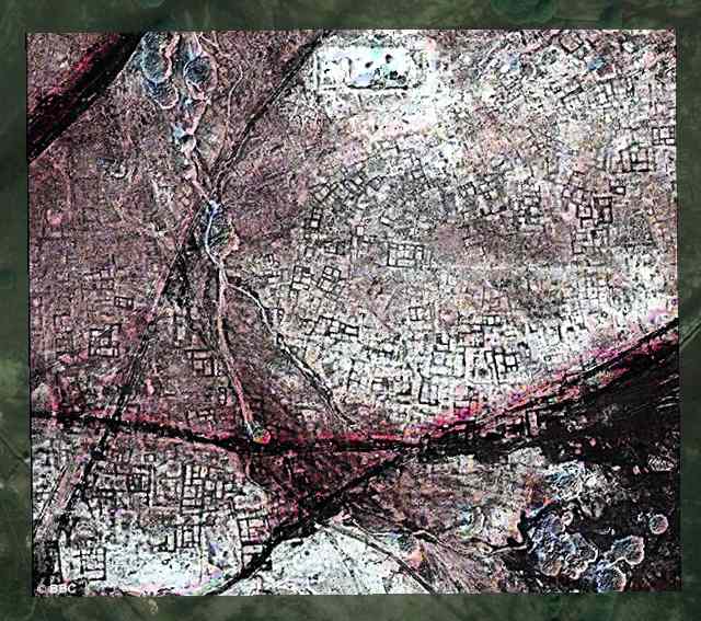
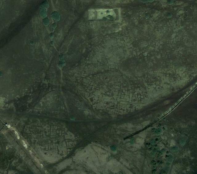
Meanwhile, a short video excerpt (viewable by all) has the presenters looking breathlessly at infrared imagery from Tanis, which appears to reveal a hitherto hidden cityscape for this ancient Egyptian city. However, the presenters oversell the case somewhat: Tanis has been extensively excavated for some time, and its foundations are documented; they are definitely visible on Google Earth’s base imagery, though we get a somewhat clearer view at infrared wavelengths. So, just to be clear, Tanis isn’t a “lost city” that has just been found, as the documentary’s title might lead you to infer. Here’s the location in Google Earth, with and without the infrared image overlaid (taken from the Daily Mail’s story):
Another BBC press handout is more promising, however. Not far south of Saqqara, near the Pyramid of Khendjer, an infrared image is marked to show the location of one of the buried pyramids. It certainly looks plausible that this feature turns out to be a newly discovered pyramid:
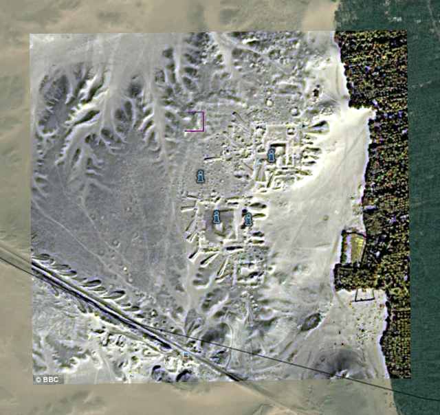
In the absence of any further information online, we’ll have to wait on the documentary to tell us whether an excavation corroborated the promise of this particular image.

I’ve overlaid both images in Google Earth so you can check them out for yourself. Download this file, and open it in Google Earth. Double-click on an overlay to zoom in. Be sure to play with the opacity slider for each overlay to see how the imagery compares with Google’s own base layer. In both locations, there are multiple versions of the base layer from multiple years, so do check to see how the site has changed over the years (by using the historical imagery slider in Google Earth).
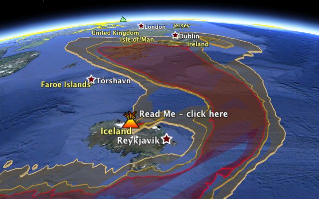
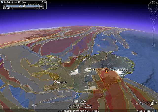
Grimsvötn’s ash cloud visualized in Google Earth

With erupting Icelandic volcanoes seemingly becoming an annual event, Adam Burt has overhauled his ash-cloud visualization tool for Google Earth, which he first made for Eyjafjallajökull’s eruption in June of 2010. Based on data gleaned every six hours from the UK Met office, the resulting network link visualizes ash density from Grimsvötn at different times and airspace heights, and can be played as an animation. Here it is — open in Google Earth.

Interesting to see how at different heights, the ash heads off in completely different directions.

Phylogenetic trees in Google Earth, redux

Starting in 2006, several people were experimenting with phylogenetic tree structures visualized in Google Earth, and these experiments were blogged here, here, here and here. Unfortunately, most of these experiments are no longer online, so those articles are now linking to nonexistent pages.

But that doesn’t mean that these kinds of visualizations have stopped filling a need. Most recently, Christian Anderson went looking for a script to build phylogenetic trees in Google Earth, couldn’t find the ones linked to here in Ogle Earth, and so decided to build his own.

He sent over the result, and it is worth posting here for the sake of future web searches. This is a zip file containing the a script written in the R language, as well as a sample KML file. He’s looking for feedback.

GeoEye publishes post-raid satellite image of Bin Laden compound

Via the Map Room, news of a brand new satellite image taken today, after the raid on Osama Bin Laden’s compound.

It’s by GeoEye, and the caption reads thus:

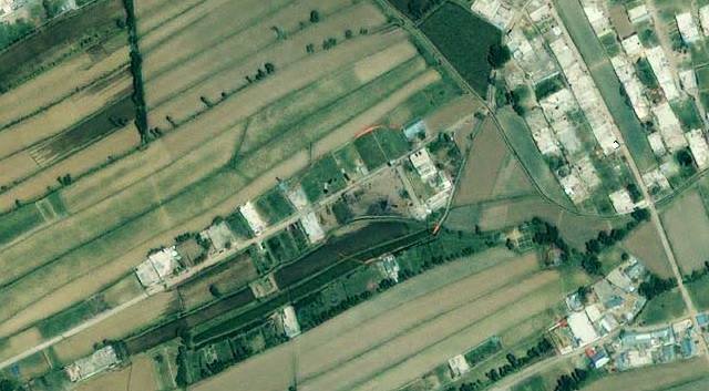
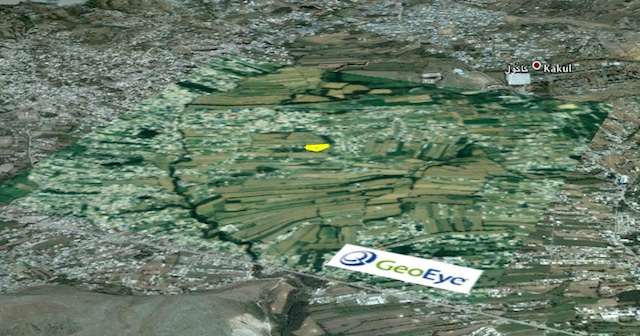
This one-meter resolution image shows a walled compound in Abbottabad, Pakistan. According to news reports Abbottabad is the town where Osama bin Laden was killed by U.S. forces. The image was collected by the IKONOS satellite on May 2, 2011 at 10:51 a.m. local time while flying 423 miles above the Earth at an average speed of 17,000 mph, or four miles per second.

That would place the timing of the image at just under 10 hours after the attack.

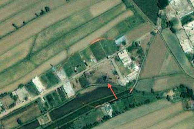
What it lags in resolution vs the DigitalGlobe image from January 2011 (blogged previously) it makes up for in terms of timeliness and color. In fact, the crash site of the problem-helicopter seems plainly visibly (to my eyes) as a blackened helicopter-shaped mass. While there are photographs around of helicopter chunks eventually being hauled away, this satellite image seems to have been taken before then:

As with the DigitalGlobe image, it looks great when overlaid on Google Earth, so here is the KMZ file (2MB). As usual, play with the opacity slider to compare vs the older imagery from 2005 below it, and remove the outline of the compound to get a better look.

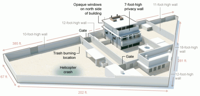
UPDATE May 3: A graphic made by the New York Times places the helicopter crash at the same location as indicated in the image above:

[Update May 3: Google today updated its base image layer to include imagery from Abbottabad taken on May 9, 2010 — just under a year ago. You can still see the imagery from 2005 (and 2001) by using the historical imagery time slider tool in Google Earth.]

In the Situation Room, aerial imagery of the Bin Laden compound

A closeup of that photograph making the rounds of Obama and his team following the raid on Bin Laden’s compound in the Situation Room: (Click to enlarge)

Sure enough, it is an aerial surveillance image of the compound. Also note that “a classified document seen in this photograph has been obscured,” as the caption puts it. What’s interesting is that this document too — for as far as I can tell through the pixellation — looks like a highly detailed aerial image; probably so detailed that the US military would rather us not know just how detailed it can get.

2011 DigitalGlobe imagery of Bin Laden compound, now on Google Earth

UPDATE: A new post: GeoEye publishes post-raid satellite image of Bin Laden compound

Via a comment left under the previous post here on Ogle Earth, a pointer to just-released high-resolution satellite imagery of Osama Bin Laden’s compound, published by DigitalGlobe to their Flickr account. Dated January 15, 2011, and showing a scene with denuded trees, the black-and-white image clocks in at 5368 × 5719 pixels, making it an ideal image to place as an image overlay into Google Earth.

So without further ado, here it is as a KMZ file to be opened in Google Earth. It’s 6MB, so give it some time to open. As usual, play with the opacity slider on the left-hand side to compare the base imagery (from June 15, 2005) with the updated B&W imagery from 2011. I’ve also added an outline of the compound; feel free to turn that off to get a better look.

As you may know, there is also a layer in Google Earth that outlines the locations of DigitalGlobe satellite images taken over the years (under “More”). I actually went looking there today to see if there had been any recent activity over Abbottabad, because in past cases (such as when Israel destroyed a nuclear reactor in Syria in 2007), an area of close interest to a DigitalGlobe customer would later show itself to be the location of a military strike. The most recent date shown for a DigitalGlobe image of Abbottabad is 2006… followed of course by the current image from January 2011. So could we have known (with hindsight) that something was up in Abbottabad? No, because Google Earth does not yet show where DigitalGlobe imagery for 2011 has been taken. The above image is too recent!

(For older coverage of the Osama Bin Laden compound’s location, check out my previous post.)

[Update May 3: Google today updated its base image layer to include imagery from Abbottabad taken on May 9, 2010 — just under a year ago.]