Roderic Page at Iphylo points to Bill Piel’s Experimental Google Earth Phylogenetic Tree Server, which lets scientists upload georeferenced phylogenetic trees as textfiles and then visualize them in Google Earth. (Definition of Phylogeny, tree map).
Here is a sample (ZIP). It shows views like this:
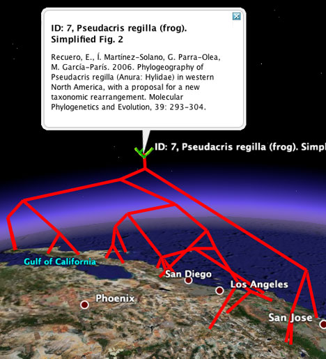
That’s an awesome bit of automated visualization.
You may remember Guiology‘s work on tree maps using Google Earth, posted a few weeks ago, using the phylogeny of the H5N1 avian flu strain. Bill Piel’s work lets anybody visualize this kind of hierarchical data.
Iphylo’s Roderic has some very interesting ideas about what these geospatial tree maps can tell us, and it’s well worth reading. (His suggestion of using node height as a indicator of age was even anticipated by Andrew @ Guiology.) Roderic also suggests that panbiogeographers (definition) take to using Google Earth as a visualization tool.
Bill Piel asks that only taxonomic phylogenetic trees be uploaded to the server, presumably because the network link will show them. But his work could easily be adapted to visualize non-scientific tree maps that have a geospatial component — for example, distribution channels for businesses, or the diffusion of technological and cultural ideas.
Dear,
I’m working on an alphabet based upon forms I spot in buildings on the Google earth. Working on it at the very moment…
Fly away and see my adds :: TO MY PORTFOLIO
Kind regards
Hi Grapplica, I blogged you 10 days ago:-)
“The latest post, regarding Google Earth and data visualization, has been temporarily removed. It has been decided that it is in the better interest of our scientific pursuits that the post be taken down until certain work is submitted for publication. Then, when a full interpretation of the visualizations is possible, I will re-release images and release some of the KMLs also. Thank you for your interest. Sorry for the teaser.”
sorry, forgot the source url:
http://guiology.blogspot.com/2006/05/independant-study-wrap-up.html“>http://guiology.blogspot.com/2006/05/independant-study-wrap-up.html”>http://guiology.blogspot.com/2006/05/independant-study-wrap-up.html