You’ve seen tree maps used before: They’re a visualization technique for showing hierarchical data inside a fixed space, like so.
Datasets about influenza virus mutations are hierarchical — there are ancestor- and offspring strains — so these naturally lend themselves to a tree map visualization technique. But such data can also have a geographic component, related to where the strains are reported — and this is what led Andrew at Guiology to perform a remarkable experiment: Using Google Earth as a geospatial alternative to tree maps for visualizing such data.
The results are very pretty indeed:
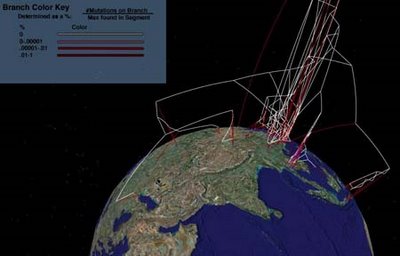
Andrew has a thorough write-up, with much more eye candy. [Update: Andrew will post again when the research is complete. In the meantime, consider the image above to be a teaser.]
Imagine what this could look like when Google Earth gets a timeline. (I’m trying to get my hands on an actual KML file of this unexpected, highly creative use of Google Earth.)
Tremendous stuff.
3-D data visualization (something very different than static 3-D models) is the most unheralded, under-utilized capability of the GE interface. The ability to render complicated datasets in a visually coherent 3-dimensional context that the user can easily manipulate and interrogate is a significant leap forward in a world that is too often hampered by the limitations of the spreadsheet.
With these powerful capabilities also come the necessity for a younger generation of Tuftes, Clevelands, and Wainers to help the rest of us combine aesthetic design with clarity and intellectual responsibility…
Brian
That might be the case Brian, and I don’t necessarily disagree that 3D data visualization might prove to be an interesting leap in this young and promising discipline, however most of the projects that tried using 3D environments for data display in the past have been quite unsuccessful. A great exception to this is Geotime (http://tinyurl.com/d8l9u) which is quite an interesting and smart approach to the problem, in particular for the type of interaction used.
Best,
Manuel