Category Archives: Uncategorized

Short news: Miniature China redux; America’s gerrymanderiest districts

Two quick ones that caught my fancy:

Google Earth imagery: Northern exposure, southern exposure

High resolution imagery of remote places can be mesmerising. Take, for example the southermost high resolution imagery currently available in Google Earth (as far as I can tell), of Candlemas and Vindication islands, part of the South Sandwich Islands, at 57 degrees south. The satellite image is just crawling with icebergs, and the quality is stunning:

ssi.jpg

Here is a direct KML link, from the Global Volcanism Program, a great site that is thoroughly georeferenced with KML files. (And here is the Tagzania link.)

Furthest north, I found two high resolution areas at 77 degrees north: In Russia, the northernmost bit of Novaya Zemlya, and in Canada, Intrepid Inlet in Prince Patrick Island.

Finally does anyone know what this high resolution area in Norway is good for? I suspect it is a shooting range, but there aren’t any Google Earth Community postings about it (which is rare, these days:-).

For the Mac: Export from iPhoto to KML

iPhotoToGoogleEarthIcon.jpgWhat’s the state of photo georeferencing like on the Mac ? Well, it’s been lagging compared to what’s on offer for PCs, especially if you look at the latest version of Picasa, but now there’s a catch-up effort under way. Craig Stanton has been working on iPhotoToGoogleEarth, a plugin that exports iPhoto photos with EXIF coordinate metadata to KML. It’s still in beta, and doesn’t yet work on Intel Macs, but do give this free software a try and help with feedback.

How do you attach EXIF coordinate metadata to photos using the Mac in the first place? Craig recommends GPS Photo Linker, another free application which takes time-coded GPX data and marries it with your photos’ time-coded EXIF data.

For getting GPX data off GPS devices, try LoadMyTracks, a wonderfully simple yet effective free application for importing GPX tracks onto your Mac. (It imports tracks as KML as well.)

If you need more advanced support for specific GPS devices, MacGPS Pro 6 does that, and a lot more besides ($50).

Short news: GeoServer; Sweden; Alaska wave; directional icons…

A collection of short news items that is rather longer than I expected:

  • GeoServer is up to version 1.3.3. The latest release has “some enhancements and fixes to the KML output format so it will work with the newer versions of Google Earth.” Download here.
  • Sweden is relatively underrepresented when it comes to Google Earth’s base data (What, no Göteborg?). Now someone has figured out a way to superimpose high resolution tiles of Swedish web mapping service Eniro, via a network link.

    eniro.jpg

    Very slick — just make sure you’re not looking at areas that are already in high resolution in Google Earth, or where Eniro’s data has been tampered with by the Swedish government for “security” purposes. Actually, come to think of it, this should make it even easier to find those spots that do have something to hide. (A nice find by Le Blogue du LFG – Guadalajara.) Anybody working on getting Géoportail’s tiles into Google Earth?:-)

  • I had never heard of the 500-meter high wave that swept through Lituya Bay, Alaska, after an earthquake in 1958. I do now, thanks to aerial imagery and a map that somebody has turned into a KML file. A lovely piece of geographic exposition.

    alatsunami.jpg

  • The variety of GIS, AEC and BIM 3D applications out there never ceases to amaze me. Version 5.1 of Navisworks Jetstream, which seems to be used for visualizing complex pipe assemblies, will now export to KML. (Mmm, it also has stereo viewing built in.) (Via JTBWorld)
  • Following this Ogle Earth article on directional icons for weather symbols, Japan’s Bugs Bunny blog comes up with directional icons for photos, which depict the direction in which a photo was taken. I think that’s a wonderful idea. Here is Bugs Bunny’s example.
  • One of the illustrations in this Cadalyst magazine article on how SketchUp is being used by new users and by schools shows a chess piece being made with SketchUp. Now that Battleships exists in Google Earth, this got me thinking… How about a chess game in Google Earth? Of course, it’d be a game where you move the chess piece not so much when it’s your turn but whenever you manage to travel to it. You’d then have to “carry” it to the correct square to drop it. Variations of the game could involve allowing you to “carry” up to two pieces at a time, say:-)

    (Tron would also be a wonderful candidate for a real-life game, but it turns out it’s so wonderful that it’s already been done, as reported by we-make-money-not-art back in january 2005.)

  • The US NOAA has a new website where many of its RIDGE radar images can be uploaded as KML. They’re asking for feedback, so: Except for the dataset with warning polygons, only static downloads available. Is this for bandwidth reasons? Wouldn’t network links refreshing every 30 minutes or so make more sense for visual weather data?
  • Geosoft’s Dapple is a specialized application (Windows XP only) derived from NASA World Wind that focuses just on just the tools useful for the Earth sciences. Interestingly, the open source status of Dapple means that World Wind developers will be able to incorporate Dapple’s innovations in future versions of World Wind.
  • 3D city updates: London’s Canary Wharf is also now available in Google’s 3D Warehouse, notes Digitally Distributed Environments. Vancouver has 3D buildings ready for your perusal, notes Google Earth Blog. (Note: Google Earth Mac beta has issues with Vancouver.) [Update 2006-07-23: La Défense in Paris is also available in the 3D Warehouse.]
  • Speaking of Vancouver, GeoWeb 2006 is taking place there next week, July 24-28, and Google Earth CTO Michael Jones will be a keynote speaker.

Bright covers Google Earth

For the Dutch speakers among you — Bright, a very hip paper magazine and website that perhaps best corresponds to a Dutch version of Wired, has a long feature article by David Lemereis on “The revolution of Google Earth”. There is also an additional how-to blog post with precise instructions and copious links.

bright-google.jpg

This is easily the best big-picture article I’ve read to date about why Google Earth constitutes a sea change in how we can navigate information. And I don’t just think this because David interviewed me for the article :-) (in beleaguered Dutch — my tech vocab is resolutely in English). David “gets it”, but he also articulates why.

Short news: EarthBooker; miniature China

  • EarthBooker launches a service whereby you yourself can automatically add your hotel to their database and position it using Google Earth. It leads you through the whole process, including setting up an account, and then at the very last moment, after you’ve done all the work, it informs you that you’ll have to pay them if you want your hotel to be visible with their service: $5 for a week, $15 for a month, etc… The press release doesn’t mention that it costs to be listed, nor does the website. In fact, consumers using the service have no idea that they are only seeing hotels that have paid to be there. They may assume, as I initially did, that the list is comprehensive. There’s no way to avoid concluding that this constitutes two counts of misleading advertising. (Mac users are spared the bother, as it doesn’t work with the Mac version of Google Earth.)
  • Le Monde comes with its own multimedia Google Earth sightseeing guide, featuring some of the more stunning aerial views. You’d think the editors would add a link to the actual image in Google Earth, but no… It’s the equivalent of listing the titles of your favorite sites, but then not showing their URLs.
  • This post of Google Earth Community pointing to a spot in a remote part of China where there is a giant miniature landscape of another spot on the disputed Chinese-Indian border (if that makes sense) has received plenty of web attention today. Even The Age picked up on it. It’s certainly one of the weirder views available in Google Earth.

Israel-Lebanon conflict, now in KML

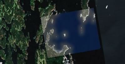
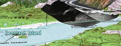
Following up from last night’s post, where I lamented the lack of geospatial documentation of the Israel-Lebanon conflict — I’m glad I didn’t start on a KML file because this morning’s trawl through the newsfeeds brought up an exhaustive and wholly impressive KMZ file documenting with pinpoint accuracy (where possible) the events of the past week on both sides of the border. For example:

bridgeleb.jpg

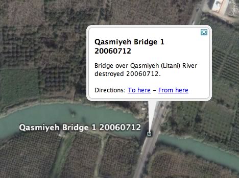
Here is the file’s launch page. Leave it to the locals to come up with the most immersive way into this war.

How would I improve it? I’d turn it into a network link, so that it gets updated automatically as content is added; I’d put individual day’s events in folders, so that a timeline can be simulated; and I’d use different icons for different kinds of events — different colors for different actors, and different symbols for rocket attacks, plane attacks, incursions, abductions, etc… But all that takes time, of course, and preferably a spot outside of a warzone.

(Finally, a KML feature request: It would be nice to be able to categorize KML objects, so that you could filter for, say, just Hezbollah rocket attacks, or just Israeli bombardments on July 18.)

(Via NL-Outsidethebox)