- Google Earth CTO Michael Jones is manning a reconstruction of Starship Enterprise’s bridge as part of a drive by Google to recruit engineers from among the ranks of Star Trek fans at a convention in Las Vegas, reports AFP. What’s on the Enterprise’s screens? Fittingly, it’s Google Earth.
- Sneaky: Google calls for feedback from Bahraini users, reports Gulf Daily News. Says a Google spokesman, while trying to stifle a grin at the good fortune of this PR coup:
We have heard conflicting reports about Google Earth access problems for our users in Bahrain and we are looking into these reports to determine the cause and welcome any input from our users there.
It’s safe to assume that by now pretty much everyone in Bahrain wants to try this Google Earth thing, whatever it is, to see what the fuss is about.
- Another virtual globe hits my radar screen: Eingana. Not sure about its chances, as it costs £10 and yet doesn’t have Google Earth’s specs. Short review.
Category Archives: Uncategorized
Missed Connexion
Connexion, Boeing’s in-flight broadband internet service, is being shuttered, reports the Wall Street Journal, citing insufficient users willing to pay. That’s a real setback for what I assumed was the unassailable march forward of ubiquitous wifi everywhere, including on planes. I used Connexion on several SAS flights between Stockholm and New York last year and I was immediately smitten — in fact, it was indispensable on one occasion.
It’s also a tragedy for my Google Earth experimentation ambitions. I just recently bought a GPS device with the full intention of making my own DIY live flight tracker using Google Earth, a window seat and an in-flight wifi connection.
How are we going to have Google Earth be the next-generation flight tracker on planes if there is no internet access to feed it? With Google getting into the free wifi business, perhaps buying Connexion on the cheap would be a logical fit: It would give Google-branded free wifi to a grateful yet captive audience of flyers (they’d all need to register with a gmail account, of course) while other passengers would get to stare at Google Earth for hours on end, with nearby plane data provided by FBO, as well as airport approach routes and weather overlays. That’s a lot of free advertising for Google.
(PS: FBOWeb’s flight offerings for Google Earth have expanded greatly since last I checked. This page now contains links to flight plans of planes involved in recent incidents, an hourly snapshot of all US flights in the air, and, in the aftermath of the latest terrorism scare, flight traffic in and out of London airports.)
Short news: KML for the tricorder; 3D camera
- Ah, I get it. Google announces the ability to add KML data to your
tricorderflip-top cell phone at a Star Trek convention. Google Maps Mania has the details. - Digital Urban Environments has yet another clever idea, well implemented. Take a paper cutout model of a skyscraper, scan it, import it into SketchUp, and fold it virtually until you get an actual SketchUp model, textures and all.
- I missed seeing a demo of the 3D LIDAR camera at Science Foo (so much to choose from, so little time). Apparently, they cost $100,000 a piece at the moment, but that price would plummet if there were mass orders. People who did see the demo came away very impressed, so much so that some felt it was an obvious mass technology of the future.
- The free and open-source GeoServer v1.4 is out.
- No SketchUp 3D Base Camp this year for SketchUp users, reports AECnews.com. Only a year ago, this was the do that first started the rumors about a Google-SketchUp hookup.
- GeoRSS Blog addresses the problem of multiple variants of GeoRSS. The upshot: Choose ‘Simple’ or ‘GML’ and stick to it.
From SketchUp to SimCity 4
Another milestone on the way to mirror world – virtual world convergence: On the SketchUp Pro user forum, “starrdarcy” shows us how to turn SketchUp models into SimCity 4 models. The only hiccup: You need to first export your SketchUp model as a 3DS file, and that’s not something the free version of SketchUp does. (Are there free/cheap third-party converters out there?) Also, there is still some tweaking to do to get from before to after — it’s not push-button yet. But the resulting eye candy is glorious:

3D geobrowsers: Yahoo!’s options
Via The Map Room, news that Yahoo! Maps has added high resolution imagery of some 30 non-US cities. A cursory look seems to put the resolution there on par with that of Google Maps.
An intriguing question: Could it really be that Yahoo! is the only one of the top three search engine companies not working on a 3D geobrowser? Unlike Microsoft, they don’t have a flight simulator game to repurpose. There are only three options, then: Either Yahoo! thinks 3D mirror worlds are a fad (something which Microsoft clearly does not, qv. PhotoSynth and the purchase of Vexcel) or else Yahoo! is going to have to get itself the technology somehow.
Barring an in-house effort, I think they would have to license something from Skyline‘s SkylineGlobe, just like France’s GéoPortail is doing for their upcoming 3D content. It wouldn’t even have to be a stand-alone application, as in-browser 3D technology is now “good enough” to portray 3D virtual globes (with a much greater installed base, and no need for downloads). Or maybe Yahoo! would want to own the technology outright… Or might they just go the radical route and build something with NASA’s open-source World Wind?
In other words, it’s quiet over at Yahoo!, and I don’t want to assume it’s because they’re dropping the ball on 3D virtual globes.
Short news: EditGrid redux; Google saves redux
- Valery Hronusov is making good use of EditGrid to calculate great circle distances.
- Google Saves, continued: WorldChanging has anecdotal evidence of Google Earth helping locals identify air-drop sites in Surat, India after the flooding there last week. (Thanks, Jonathan)
- Richard Treves — he of the KoKae tutorial screencasts for Google Earth — has built a template for the education-oriented Moodle content management system that produces KML for databases that contain latitude and longitude data types. If you use Moodle, here is the thread you need.
- Interesting item in the comments, worth singling out: “Are there any guide/climber/back country adventure types out there who are increasingly using google earth to scout trails? I need your stories and comments for an article in a national magazine. Please contact Jon kovash.
Visualize Colorado public school test scores
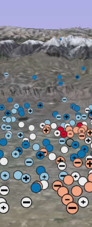 Brian Timoney and Ubiquity Design come out with CSAPscores.org, yet another visually striking geospatial data visualization — of Colorado public school test scores, by district and by subject. The main site is Google Maps-based, but there is also a Google Earth launch page where the data is presented as KML files. I find it easy and intuitive to use, and it should be a real boon to parents. With any luck, these kinds of visualizations will soon be the norm for this kind of data. Or, as Brian puts it:
From where I sit, the twin obsessions of the American middle class family are real estate and education. Zillow seems to have the former covered. But with all of the controversy about failing public schools in the US and the federal No Child Left Behind Act, shouldn’t accessible map-based interfaces be a required part of the conversation?