[Update April 5: New post: Google adds satellite imagery to Google Earth; Black box heard?]
[UPDATE March 22: I have updated the KMZ file for Google Earth to show the latest imagery released by China, pinpointing another possible peace of debris from MH370. I’ve now also added the imagery itself to the placemark’s info box.]
[UPDATE March 20: Here is the KMZ file for Google Earth showing the exact location of those two artifacts (BBC News) noticed on satellite imagery taken by DigitalGlobe on March 16. (On casual inspection, they look to me to be sun reflections off slightly bigger-than-average waves.) If this is indeed the missing MH370, they are further south than the final ping arc and estimated range circle — and that would be because MH370 could have kept on flying for up to another hour after the final ping, because of the currents, as these images were taken 8 days after when MH370 would have crashed, and perhaps because the fuel reserves lasted longer than thought.]
[UPDATE March 17: New post: MH370 – Airports in flight range on Google Earth with over 3500 Asian and australian airports]
[March 17, 17:45 UTC: Updated at end of this post with added context re the reason for the two arcs.]
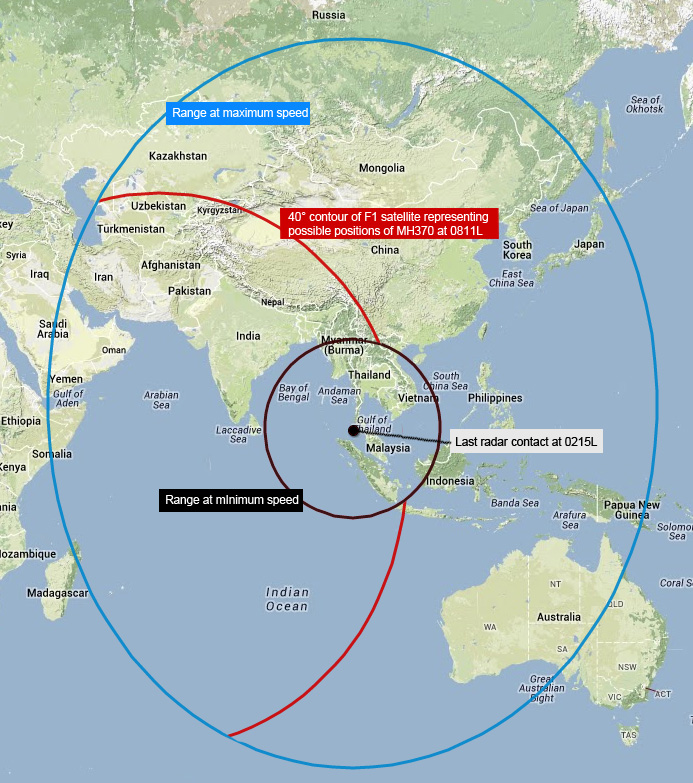
The disappearance of Malaysian Airlines flight MH370 has had me glued to the Internet. Now over a week into the mystery, more specific data has begun to emerge regarding MH370’s apparent flight path and possible last locations, from two distinct sources. I felt I could contribute by adding these as accurately as possible to Google Earth, for others to use. Here’s the resulting KMZ file for Google Earth. Read on for the context.
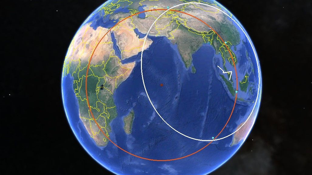
The most recent source of data was released on March 15, from an Inmarsat satellite in geostationary orbit above the Indian Ocean, which tracked a final ping from MH370 to an arc of possible locations on Earth. The information, released by the Malaysian government, did the rounds of Twitter (and the NYT) in this form:
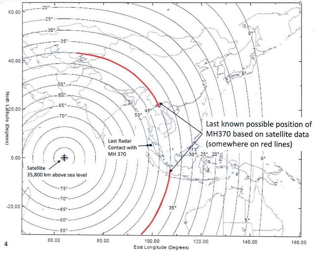
(According to the experts on the Professional Pilots’ Rumour Network, the degree lines shown in the diagram depict how high above the horizon the satellite is when viewed from that location. That’s why right below the satellite the angle is 90°.)
Looking up possible Inmarsat satellites on Wikipedia led to one exact match: Inmarsat-3 F1, which sits 35,700km above the equator at E64.5°. This is the exact view that satellite has of Earth:
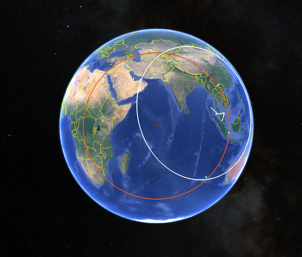
Using this KML circle generator, I then recreated the circle from the diagram (in orange in Google Earth), which turns out to have a radius of 4,750km. I also added the points demarcating the start and end of the two arc lengths, as depicted on the diagram.
On March 14, sources described to Reuters the details of Malaysian military radar data, which saw MH370 follow specific waypoints as it veered across the Malaysian peninsula and then set course for the Andaman and Nicobar Islands, before going out of radar range.
The coordinates for these waypoints (and some amazing maps to go with them) can be found on SkyVector:
IGARI: N6°56.20′ E103°35.10′
VAMPI: N6°10.92′ E97°35.14′
GIVAL: N6°59.99′ E97°59.99′
IGREX: N9°43.47′ E94°24.99′
I then converted these to decimal degrees before adding them to Google Earth.
To these coordinates, we can of course add the coordinates of KUL, Kuala Lumpur International Airport (N2.73° E101.71°) and also the last recorded position of MH370 on Flight Aware, a public flight tracking service, which placed the plane almost exactly half-way between KUL and IGARI. These six points together allow us to reconstruct the flight path for the first two hours or so, depicted as a path in Google Earth.
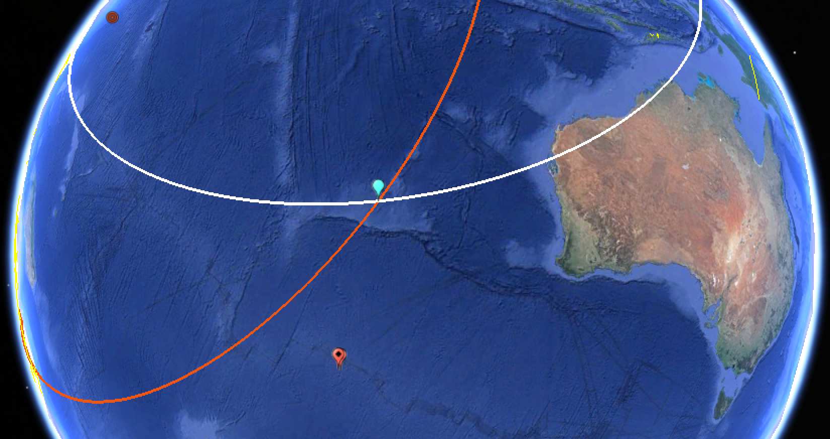
Finally, I’ve added a second circle (in white on Google Earth): This circle has the IGREX waypoint as its center, and it bisect the two furthest points on the two Inmarsat arcs depicted in the diagram. That circle’s radius turns out to be 4,400km. Given the cruising speed of a Boeing 777-200 at 905km/h, that circle depicts the distance MH370 would have flown in just under 5 hours from there (assuming a straight line).
As new information becomes available, I will try to update this post as well as the KML file.
UPDATE March 17, 17:45 UTC: As per this blog post on TMF associates, the interruption in the arc near the Gulf of Thailand is due to the Malaysian government’s own calculations that MH370 flying at its slowest possible speed in a straight line would not be in this region. This, however, assumes that MH370 would henceforth fly in a straight line, which it obviously had not been doing. So in practice, the entire orange ping arc inside the white range circle is a valid search location.
(It had previously been mooted that the interruption in the arcs was because another Inmarsat satellite would have picked up MH370’s ping had the plane been that far east. But in fact the interruption is not centered on the equator, as it would have had to be had it been due to a bisection from another geostationary satellite).
This is brilliant. Thanks!
Excellent work on setting the constraints in such a clean fashion. Mahalo!
Well done, and the first step in a proper crowdsourcing effort. Bravo!
I count 8 airports with runways capable of handling a 777 landing. These are on the red northbound the loop starting in Jakarta Indonesia and ending in Kazakstan. The details are posted on my Facebook page (username Van Warren). I will append these airports to the kml file.
I have modified the kml file with the 8 annotations including ping error and runway length, sent to your gmail account.
From fuel considerations the aircraft was either on the ground, or near to landing when the ping that caused the red arcs via Immarsat occurred. This, plus runway length reduce the 3500 possible landing sites to 8. They are:
Hit #1: Soekarno-Hatta, Jakarta 11 mile ping error 11 kft runway
Hit #2: Tan Son Nhat, Vietnam 42 mile ping error 10 kft runway
Hit #3: Ubon Ratchathani Thailand 1 mile ping error 10 kft runway
Hit #4: Khok Samran Thailand 3 mile ping error, 5 kft runway
Hit #5: Sakon Nakhon Thailand 3 mile ping error, 9 kft runway
Hit #6: Xieng Khouang Laos 6 mile ping error, 9 kft runway
Hit #7: Putao, Burma 61 mile ping error 7 kft runway
Hit #8: Shymkent, Kazakhstan 5 mile ping error 10 kft runway
These are marked in finer detail in the kmz file transmitted last night.
Hi Van,
Your KMZ file is a local copy only — only you see the changes.
Bear in mind too that the ping arc is just an approximation – likely with a margin of error of several hundred kilometers.
Finally, the ping arc is only the last know location. MH370 may have continued flying for up to an hour or longer, or even turned back from there…
Some reports say it could land on a 3000 ft runway . full reverse thrust is uncomfortable !! http://www.boeing.com/assets/pdf/commercial/airports/acaps/7772sec3.pdf
4000′ dry to 6000′ wet runway. see landing chart for 777.
Shymkent has military aircraft parked on the ramp so it must have a military presence on the field which is harder to bribe not to see things.
Try going about 65 nm farther south to Tashkent. Runway length 11,500 ft, handles large airliners regularily, NO military so bribery would be more effective, has several all weather hangers capable of having a 777 taxi in and close the doors.
excellent effort you guys…
i tried to recreate but i was stuck at the gap between north arc and south arc.
i just figured out the what’s with the gap in the arc was all about.
Great point Stefan. Do we have a reliable figure for the margin of error?
Well, If the ping arc is drawn along the nearest 5-degree line, then we’re talking an error margin of around 250km in either direction of that arc. (The distance between the 45-degree line and the 40-degree line is around 500km.)
Stefan,
Per your 17 Mar 2014 comment, the true geodetic (ellipsoidal) distance between 40S and 45S latitude on the same meridian (I used 100E longitude) is 555,415.3476 m or about 555.4 Km. Add a flying height of 10,000 m, the air distance becomes: 556,111.5133 m or about 556.1 Km.
ref: http://www.ngs.noaa.gov/cgi-bin/Inv_Fwd/invers3d.prl
The rule of thumb for geodesists at mid-latitudes is 111.1 Km per degree of latitude at sea level. It varies slightly depending on the latitude from about 110.6 Km at the equator to 111.7 Km at the poles. When you account for a flying height of 10 Km, that adds about 0.1 Km.
Presumably today’s modern air mileage calculators use a WGS84 (or later) ellipsoid as a reference surface and not the old fashion classical earth sphere with a constant radius.
Bruce H
Let’s try this. If we draw an inner and outer ping border in red using your estimates we can convert the line to a bounded band. If we draw an inner and outer fuel border in white we can convert the expected range to a bounded band. This would improve the first order approximation significantly. After working with that, we could draw bands of probability and search the high probability bands first. Whoever orchestrated this is counting on us to lose interest and we shouldn’t let them until the A/C, passengers and crew are found. I can unzip the kmz file and starting working on this, but if you have the generating geometry it might be easier for you.
Best Timeline as of 4:45 PM March 17, 2014 via Suzanne Malveaux CNN
Sat Mar 8 Boeing 777-200 with 227 passenger and 12 crew = 239 souls on board
12:41 AM Flight MH370 departs Kuala Lumpur Elevation 69 feet with 13000 foot runways
01:07 AM Last ACARS Transmission Sent Via Satellite
01:19 AM Copilot provides last verbal communication with controllers, “All right, Good night”
01:21 AM Transponder Goes Off at same time VietNam ATC check-in is supposed to occur.
01:30 AM All civilian radars lose track of aircraft all together
Erratic altitude changes with maximum of 45,000 feet 2000 feet above service ceiling
01:37 AM Scheduled ACARS Transmission Never Sent
02:15 AM Malasian Military Radar Detects Plane of Malay West Coast, Off course
06:30 AM Flight MH370 due in Beijing 5 hours and 49 minutes after takeoff
08:11 AM Immarsat handshake received 7 hours and 30 minutes after takeoff
Shouldn’t there have been hourly handshakes occurring during the 7.5 hour flight? What do those pings tell us? I’d like to see those breadcrumbs.
is there a plot of arcs for all of the hourly MH370 Inmarsat pings, and not only the final one?
While this will not provide a final exact position, any east-west displacement constrains total north-south distance traveled.
http://theaviationist.com/wp-content/uploads/2014/03/Search-MH370-WaPo.jpg
I don’t know if these are just estimations or not…
How many hourly handshake pings did the Immarsat satellite receive? Why is only the last ping mapped?
I agree with everyone asking where the other pings are that this would be useful information. However, that info has not (yet?) been released.
http://theaviationist.com/wp-content/uploads/2014/03/Search-MH370-WaPo.jpg
I’ve now found a good explanation for why there may only be one ping arc from Inmarsat:
http://www.pprune.org/rumours-news/535538-malaysian-airlines-mh370-contact-lost-263.html#post8383477
Basically, it’s because the satellite would only have kept the most recanted updated ping. The pinging was never meant to plot a route.
The final ping was at 00:19 UTC, initiated by the aircraft not the regular half hourly one at 00:11 UTC and this is suggestive of an engine surging before fuel cut out and the generator coming back online briefly Thus the real contact arc for the search area should be the arc for the 00:19 UTC ping, not the 00:11 UTC ping.
Do these calculations presuppose that the plane is flying at altitude? If so, where would the arc fall if the plane was presumed to be on the ground?
Or slowly (or otherwise) sinking under x feet of water?
Can you provide circle graphics of the various ‘pings’?
Each ‘ping’ should provide a different circle.
Great graphics. Can you provide permission to include them in wikipedia? They seem to have a copyright problem.
http://en.wikipedia.org/wiki/File:MH370_last_ping_corridors.jpg
see from
http://en.wikipedia.org/wiki/Malaysia_Airlines_Flight_370#Estimated_route
Sure, feel free to use them.
Has anyone seen data on the other pings? I have not.
Yes, I posted a link up above. Great job with the circles.
Also updating here:
I’ve now found a good explanation for why there may only be one ping arc from Inmarsat:
http://www.pprune.org/rumours-news/535538-malaysian-airlines-mh370-contact-lost-263.html#post8383477
Basically, it’s because the satellite would only have kept the most recanted updated ping. The pinging was never meant to plot a route.
So the other previous pings were NOT forwarded to Rolls Royce HQ and NOT stored in some data center for future engine health history information/quality assurance purposes? (raises eyebrow) If they were stored somewhere at Rolls Royce HQ, I would expect them to be accurately date and time stamped, so as to
later put together a timeline of how the engine performed or in some cases was over stressed, either by pilot error or whatever external environmental conditions.
No, not forwarded. And with a convincing reason why not (as per the article linked to above.)
Is the radius of the “arc of possible locations” calculated using the “round-trip time for radio waves to that client”? (TDMA details as from Stefan Geen’s Link) If so, what flying altitude is considered?
Couldn’t the radius be (much) shorter than that? E.g. almost right below the satellite?
Maldive people observed a low flying aircraft crossing the Maldive Island “Kudahuvadhoo” in south-easterly direction at 6:15 AM LT – that is 8:15 Malaysian time – that is 4 Minutes after the last ping!
If that observation is valid and it was MH370, considering the total flying radius and possible remaining fuel, I would assume a search radius of approx. 1000 km south-east of Kudahuvadhoo. Diego Garcia is little further away than 1000km strictly south of Kudahuvadhoo – but it was stated somewhere that the Maldives are not in search region!
Instead of searching an area of the size of Australia I would first check the Maldive / British Indian Ocean Territory area… Or is that Top-Secret due to the US military base?
No, either the Maldives story is true or the Ingmarsat pings are accurate. Not both. With the satellite 40° above the horizon for the plane, a 10km height difference would only result in a 12km error (10/tan(40)). Near where the satellite is at the zenith, yes, there a 10km height difference would make a bigger difference, a horizontal difference of up to 800km (back of the envelope: sqrt((35710^2)-(35700^2)). But Inmarsat has told us that was not the case.
Are these Inmarsat details public? I haven’t been able to find other than journalist talk…
That image was released by the Malaysian authorities. That’s it, as far as I know.
The southern intersection of the red and white circles is very close to the Diamantina Trench, the deepest point in the Indian Ocean. I wonder if that was the target.
http://en.wikipedia.org/wiki/Diamantina_Trench
I suspect it is an elaborate pilot suicide/mass murder, with the pilot not wanting this fact to be discovered for insurance or family honour reasons. The pilot/copilot somehow disabled his copilot/pilot, then turned off the transponder and ACARS, He then altered course, and depressurised the cabin – I’m curious how this is possible – flying to 45,000 feet to make sure none of the passengers/crew survived. When over the Diamantina Trench at fuel exhaustion or close to it, he ditched at close to stall speed to minimise surface debris. The aircraft may now be in 7000-8000 metres of water.
We may never find the aircraft or determine the reason for the loss, or even determine which pilot “did it”.
Bruce I would not place any credibility on Malaysian radar claims. Firstly the aircraft took off at 266,000kg with 31,000US Gallons of fuel inclusive. Climb would consume 6-8,000kg and at that weight it could not have reached 45,000ft. At such altitude it would take 20 minutes to get from 43,000ft to 45,000ft even in an aircraft light enough.
Millitary radar uses two close coupled radars one in Azimuth and another vertically inclined in Zenith, cross comparing with trigonometric calculations to estimate altitudes. At long range from Butterworth it is doubtful;the radar even saw MH370, but also at long ranges this type of missile targeting radar can make errors in altitude of up to 15,000ft.
Furthermore upon evaluating the Burst Offset Frequency Chart I notice that the period from 17:07 UTC until 17:35 UTC showed an increase in Doppler frequency whilst MH370 was under direct radar observation and giving transponder returns flying east. This frequency trend continued until a reversal at 18:25 UTC.
This infers that either the data was inverted by signal processing or data was manipulated to falsely infer a flight west. Frequency should have decreased flying away from the satellite. The Burst Offset Frequency does not support MH370 flying though the Straits of Malacca.
Sy,
re: “At long range from Butterworth it is doubtful;the radar even saw MH370, but also at long ranges this type of missile targeting radar can make errors in altitude of up to 15,000ft.”
Unless you know something I don’t the LRR at RMAF Butterworth was not missile targeting radar as you state but air defense surveillance or so-called “early warning”. That is not to say that there isn’t missile radars located there, but they do have air surveillance radars at RMAF Butterworth.
I would direct you to the Malaysian AIP Enroute section 1.6 at http://aip.dca.gov.my/aip%20pdf/ENR/ENR%201/ENR%201.6/Enr1_6.pdf
Paragraph 1.1.4 In the Kuala Lumpur and Kota Kinabalu FIRs, radar services are provided using the following civil/military ATC
Radars:
a) A 200 NM long range en-route SSR located at Bt. Chin Chin, Genting Highlands, 23 NM east of Subang –
Sultan Abdul Aziz Shah Airport;
b) A 60 NM Terminal Primary Approach Radar co-mounted with a 200 NM monopulse SSR located to the
west of Johor Bahru-Sultan Ismail Airport runway,
c) A 60 NM Primary Surveillance Radar (PSR) co-mounted with 200 NM monopulse SSR located on Bt.
Subang, 1 NM west of Subang-Sultan Abdul Aziz Shah Airport;
d) A Transportable Radar, 60 NM Primary Surveillance Radar (PSR) co-mounted with 200 NM monopulse
SSR located at KL International Airport;
e) KL International Airport Terminal Approach Radar – A 60 NM Primary Surveillance Radar (PSR) comounted
with 200 NM monopulse SSR located at KL International Airport,
f) A 60 NM Primary Surveillance Radar (PSR) co-mounted with 200 NM monopulse SSR located on Hill
Chengkuang 1.5 NM NE of Langkawi International Airport,
g) A 60 NM Terminal Primary Approach Radar co-mounted with a 200 NM monopulse SSR located to the
south of Kota Bharu-Sultan Ismail Petra Airport runway.
h) A 60 NM Primary Surveillance Radar (PSR) co-mounted with 200 NM monopulse SSR located on Bukit
Kepayang, 1 NM NE of Kota Kinabalu International Airport;
i) A 60 NM Primary Surveillance Radar (PSR) co-mounted with 200 NM monopulse SSR located in Kuching
International Airport;
j) A 60 NM Terminal Primary Approach Radar co-mounted with a 200 NM monopulse SSR located at Miri
Airport.
k) A 50 NM Terminal Approach Radar with co-mounted 250 NM conventional SSR located one each at
Butterworth, Labuan and Kuantan Air Forces Bases;
One more important set of values: The time point data @ IGARi, VAMPI, GIVAL and IGREX?
Are they available anywhere?
How would we assume that IGAR TO VAMPI was a straight line course?
There were reports of villagers and fishermen sighting low-flying object along the Bachok etc.
http://www.ibtimes.co.uk/missing-malaysian-airlines-flight-mh370-two-men-claim-have-seen-plane-plunging-into-sea-1439730
If the flight took a non-linear path along these points, we will have to further fine tune some important distances, times and extreme points.
I don’t think we know the actual path the plane took between those waypoints, We just have sources who told Reuters that these waypoints were the ones MH370 was programmed to fly to.
Apparently, there is only point data for the last waypoint: 2:15.
Re that article, I find the headline misleading. Neither man saw an airplane plunging into the sea.
How many (remote?) airports in the Maldives are good enough to land a 777? Seems like the perfect remote spot for landing a plane! Torsten
It is conceivable when MH370 went to 43K ft it rendered everyone permanently comatose, eventually including the pilot. Deliberately.
A programmed autopilot then brought MH370 down to 23K ft and flew level until it ran out of fuel.
This potentially narrows the search area.
It would be appreciated if you could provide ‘end of flight’ map detail under this scenario.
That’s what the white circle is.
While 43,000 feet is the advertised “service ceiling” of the Boeing 777, reaching that altitude would not render flight crew or passengers comatose or devoid of oxygen. Service ceiling is based upon aircraft weight, wing configuration and true airspeed. This why on long transcontinental flights the initial flight segments are often lower, then as the flight progresses, fuel is burned off reducing weight, allowing for higher cruising altitude.
Bill, I would like to discuss your statement regarding the effects of decreased osygen as you climb to high altitudes. One of my duties as a USAF Pilot was the recertification of aircraft for flight after extensive maintenance. This requires the completion of a complex flight profile which exercises EVERY system on the aircraft at the edges of their operating limits. One of the systems we checked was the oxygen system for the pilot. We would check the system at 15,000 ft before we began the upper altitude work. We checked ti again at 40,000 ft and then zoom climbed to 50,000 ft and checked tt one last time. We were trained and evaluated in altitude chambers to be very aware of the onset of hypoxia so we would not lose the aircraft if the oxygen system did not perform.
The 777 has a passenger supplemental oxygen system which can provide a small amount of oxygen to supplement the passengers needs as the aircraft decends from altitude to 10,000 ft in case of an aircraft depressurization. This is supplemental oxygen ONLY. At 40,000 ft we had to have 100% oxygen to survive.
The time of usefull consciousness (TUC) at 35,000 ft is between 30 and 60 seconds without supplemental oxygen. The TUC at 45,000 ft (after the supplemental oxygen generators were consumed is only 9 – 12 seconds.
I believe the pilot took the aircraft to “cook” their brains and render them immobile, strapped in their seats for the rest of the flight. I was like hauling sand after that. No CG changes with milling passengers, no attempts to get into the cockpit – they were dead. Just my thoughts based on my experience.
The ACARS ping circle cannot be a true circle!!
The distance is only valid if the ping was received from a transmitter located right ON the equator.
If the transmitter moves north or south from the equator, the distance will become longer because the earth is not flat :)
This means the resulting “ping circle” is not a circle but an oval. No clue how to put this in a google earth KMZ file though :)
It’s a circle. Inmarsat’s satellite sits right above the equator. It has to be — it’s a geostationary satellite. the 40-degree line of sight extends out from the satellite as a cone that intersects with Earth. That intersection is the orange circle.
INMARSAT is geosynchronous not geostationary, there is a difference and INMARSAT does wobble above and below the equator.
INMARSAT is both a geosynchronous AND geostationary satellite system. It is geosysnchronous because it has an orbital period exactly equal to one sidereal day, which the amount of time the earth takes to complete a 360 degree rotation (3 min and 56 secs shy of 24 hours which is called a tropical day, the time between two consecutive transits of the sun across a local meridian). A special case of the geosysnchronous orbit is the geostationary orbit, which requires the satellite to orbit over the equator, thus keeping it over the same point on the earth’s equator all the time.
From U.S. 7th Fleet Public Affairs
YOKOSUKA, Japan (NNS) — The U.S. Navy team operating the towed pinger locator (TPL) onboard Australian defense vessel Ocean Shield detected pinging signals, April 6.
The detected signals are consistent with sounds that would come from a black box.
The TPL heard consecutive pings at one second intervals. At the time of detection the TPL was at a depth of 300 meters, which is well above the optimal search depth where a black box would typically be detected.
Upon detection, the Ocean Shield crew turned off as much noise-producing equipment as possible to reduce the chance of false alarms, and the signal was again held for over two hours at a TPL depth of 1,400 meters. The signal stregnth increased and then faded, as would be expected with the ship moving toward then away from the signal.
http://www.navy.mil/submit/display.asp?story_id=80169#.U0M14P_vP28.facebook
Bill, I’m not sure what your response (a news blog from the U.S. Navy 7th Fleet about the Navy TPL) has to do with my explanation about the difference between geosysnchronous and geostationary satellite orbits.
Sorry that’s just where it happened to fall … :(
Are the 40° relying on a plane flying straight (meaning both wings have same distance to the ground)? What if right at the time the ping was received, the plane flew a strong turn, where plane may dip 45° to one side.
So maybe both the Maldives story and the Ingmarsat pings are accurate, but ping angle was misinterpreted. Imagine, plane came from east and turned south right before the island and by coincidence this was the time the ping was sent.
No, the 40-degree line is calculated from the distance of the ping. Read the article referenced above.
This is great to have this data in Google Earth, thank you!
Looking at the path from IGARI to IGREX as you have traced it, I’m pretty sure the aircraft could not have hit the VAMPI and GIVAL waypoints. The path length is about 790 miles, and the time from IGARI to IGREX is only 54 minutes. That’s a flight speed of around 877mph (1.2 mach)! Even reversing the order of VAMPI and GIVAL gives a path length of 770 miles, resulting in an average velocity of 855 mph. This assumes instantaneous turns, which is not quite correct, but would mean an even faster speed while flying straight and level.
The Boeing 777 cruising speed is about 639 mph (.84 mach) per Boeing’s website (http://www.boeing.com/boeing/commercial/777family/pf/pf_200product.page?)
So, even if MH370 followed this path, at some point they would have had to go supersonic, which would have generated a sonic boom, and presumably would have been heard for 10’s of miles. Also, these aircraft are not built for supersonic flight, so I doubt it is capable.
Incidentally, the straight-line path from IGARI to IGREX is 650 miles, so if the plan flew directly from IGARI to IGREX, the average velocity would be 722 mph (.94 mach). This is still stretching the capabilities of the aircraft, but is a more reasonable speed than the path from IGARI to IGREX through VAMPI and GIVAL.
Doing these average velocity calculations makes me doubt the veracity of all the way points that have been reported, even IGREX.
Mach airspeed is not constant. Mach airspeed includes adjustments based upon outside air temperature for adjustment to speed of sound. One article I read indicates that at minus 50 degrees Celciuss Mach 0.84 equates to 447knots.
With regard to the flight paths, the route between VAMPI and GIVAL would have been a blended curve. These would have been fly-by waypoints instead of fly-over waypoints. For example, the USAF when computing waypoints for low-level training flights for the B-1B uses a 7.5 nautical turn radius for computing fly-by waypoints.
Have you seen the info here: http://theaviationist.com/2014/03/20/mh370-total-recap/ It’s interesting because they show the “missing” ping data which if correct would show the linear progression to the south. It would be interesting to see the Australian government’s posted search areas on Google Earth also…
The graphic used by the Aviationist without attribution is a section from this graphic by the Washington Post, the version from March 20.
That graphic took the last known ping arc as well as the two suggested flight paths provided by the NTSB, and then extrapolated/reverse-engineered/inferred where those previous ping arcs would have been. So those old ping arcs are not based on any new, officially released data.
Perhaps the WaPo graphic was inspired by this Reuters graphic:
Scott Henderson, the designer, is explicit in this Tweet that the older ping arcs are reverse engineered:
https://twitter.com/_AntiAlias_/status/446499793313857538
In sum: It is perhaps possible (but unlikely – read this) that the NTSB has access to the old ping arcs, and then was able to use these to plot likely routes based on aircraft speed. But these older ping arcs, if they exist, have not been made public. It would be new information if they were released and that would be news. In any case, two different estimates for range based on two assumed cruising speeds combined with the last ping arc would be sufficient to create the two routes provided by the NTSB, if we assume the airline flew in a straight line for most of its missing trajectory.
Howcome everybody assumes the flight ever made it to waypoint IGREX and the time was 2:15AM?
Quoting Reuter’s article http://uk.reuters.com/article/2014/03/14/uk-malaysia-airlines-radar-exclusive-idUKBREA2D0DJ20140314
“In a far more detailed description of the military radar plotting than has been publicly revealed, the first two sources said the last confirmed position of MH370 was at 35,000 feet about 90 miles (144 km) off the east coast of Malaysia, heading towards Vietnam, near a navigational waypoint called “Igari”. The time was 1:21 a.m.
The military track suggests it then turned sharply westwards, heading towards a waypoint called “Vampi”, northeast of Indonesia’s Aceh province and a navigational point used for planes following route N571 to the Middle East.
From there, the plot indicates the plane flew towards a waypoint called “Gival”, south of the Thai island of Phuket, and was last plotted heading northwest towards another waypoint called “Igrex”, on route P628 that would take it over the Andaman Islands and which carriers use to fly towards Europe.
The time was then 2:15 a.m. That’s the same time given by the air force chief on Wednesday, who gave no information on that plane’s possible direction.”
Notice how they explecitly state “heading northwest” not “reaching” IGREX.
I believe the KMZ should pin WAMPI as the last known location and draw the white circle according to this center.
Agreed, that is an assumption, not a known fact, that MH370 made it to IGREX, simply that it was headed that way. The distance between VAMPI and IGREX is almost 500km, so that introduces an additional (smaller) margin of error as to where the ping arc meets the estimated flight range circle. But I think it is an assumption worth making in this case; MH370 had flown past all the previous waypoints. We definitely don’t know what other waypoints it flew to after IGREX, but IGREX is the last known place it was headed to, and from what we can tell MH370’s route was being flown via programmed waypoints rather than by hand.
Sounds reasonable. However, the 2:15AM timestamp must still be close to VAMPI or the speed exceeds the airplane specs.
Agreed. But in any case, the range circle is already an approximation, given that we don’t know flight speed, height and fuel reserves.
Stefan, I believe that you are misinterpreting what Bjarni is saying.
At 2:15, the place was 200 miles NW of Penang. That would be the position of GIVAL, not IGREX. For the plane to be at IGREX at 2:15, it would have have to be traveling at over 800 MPH.
I had to plot this on a spreadsheet to verify that your timestamp on IGREX is incorrect.
http://en.wikipedia.org/wiki/Malaysia_Airlines_Flight_370
Malaysian Radar at Langkawi International Airport ( 6°21’15.61″N 99°44’41.35″E) A 60 NM Primary Surveillance Radar (PSR) co-mounted with 200 NM monopulse SSR located on Hill Chengkuang 1.5 NM NE of Langkawi International Airport.
Thai Military/Civil Long Range Radar, south of Phuket International at 7°52’51.41″N 98°19’0.09″E.
Indonesian Long Range Radar west of Subang at 5°53’14.67″N 95°13’44.08″E
Indian Air Force P-12/18 Long Range Radar at Port Blair, Smith Island at 11°37’30.70″N 92°42’49.50″E.
The last radar site at Port Blair is only 155 nautical miles by GE measurement from the last observed Thai Military radar site.
If you want to see all the speculation on where MH370 could have gone, combine Stefen’s KML file with the KML file of MyReadingMapped’s Commercial Aviation Crash Sites 2011-2020.
Google Map:
http://myreadingmapped.blogspot.com/2013/01/commercial-aviation-crashes-2011-2020.html
Google Earth KML file of the above Google Map:
https://docs.google.com/file/d/0B52hHMRyBvEsbVdnUWNXX0QyYWc/edit
great work on compiling all this information , im slowly working through this blog. I work at ESRI UK and i have access to to lot of ESRI technolgy is you need any help processing some GIS data just holla at me
Is the orange ‘black-box’ accessible from the cabin?
If so, I don’t think any ping or data will exist.
Also, I understand the voice recorder is on a 2 hr loop.
Nothing there either.
This is really interesting what you have done here. I’ve been playing with your flight path kml file and have extended it a bit. It makes the assumption that the pilot continued on his NW course for no more than 500 km and that he had a specific destination in mind.
http://www.wiseoldcat.com/sites/default/files/mh370-mod.kmz
I didn’t change the arcs for the ping data. I’m assuming that those estimates are better than any I could make. A pretty good explanation of what that data is all about can be found here. http://www.themalaysianinsider.com/sideviews/article/understanding-satellite-pings-tim-farrar
And I am only speculating on the target destination. That perhaps is beyond the spirit of this page. But if it was the intent of someone piloting that plane to make it disappear forever then that target would fit within the parameters of the data that Stefan has put together. And it would have a good possibility of never being found.
Alan, check out this page and examine the chart. Let me know if you would like to discuss it further.
http://www.maritime-executive.com/article/Inmarsat-Helps-in-MH370-Tragedy-2014-03-25/
That is interesting. I can be contacted via email at “maildrop” @ the domain name in my link to the kml file above.
Hi Jafo, I put the data in a spreadsheet and managed to make a graph that looks very much like the one in that page. I then correlated that back to the original flight plan. Had the craft followed it’s proper course then the abrupt change between moving away from the satellite to moving towards it at about 18:30 UTC would have happened about 800km past IGARI or on the Cambodian Laos border. If it followed the course that the military radar (and the news) says it did then that abrupt vector change happened at about the GIVAL waypoint. That makes sense. What it does imply is that by 19:40 it was already on its southerly course towards Australia. So it’s a fair assumption that the turn would have been made at or after IGREX, possibly at the Andaman Islands. I wonder what other waypoints are within 300 km of IGREX in a NW to SW arc? I’m working on the assumption that someone is following IFR rules and trying to avoid getting too close to land (which a direct southerly route from IGREX would do).
Also a consideration is that the burst frequency offset would also be a function of climb and descent rates. How much I don’t know. And I really don’t know what the absolute values represent. Note that the first value of about 85 is at 16:30 UTC. That’s before the plane took off.
Alan, Look back at the ping chart and see where the predicted Northern route and predicted Southern divert. Check the time on X axis. According to radar, where was the plane at 2:15 MYT (18:15 UTC)?
http://en.wikipedia.org/wiki/Malaysia_Airlines_Flight_370
Alan,
See the graphic on this page labeled “Possible flight trajectories based on Doppler Effect Assessment (Graphics: MMOT):”
Do you see any problem with this?
http://avherald.com/h?article=4710c69b
The Wikipedia page states “Last primary radar contact by Malaysian military, 200 miles (320 km) NW of Penang” which puts it at or a little past waypoint GIVAL. The BFO data shows a change in direction at that time. (Towards the satellite if I’m interpreting that correctly.)
As for the possible flight trajectories on the avherald site the slower speed one (400 knts track) puts it pretty much on course with a destination of the Diamantina Trench area. It also shows an additional course change from IGREX to the SWW, possibly to waypoint LAGOG at 8°35’38.00″N 91°59’50.00″E.
The only thing that doesn’t fit is Stefan’s timestamp on IGREX of 2:15 AM.
I like a good mystery and I enjoy playing around with KML files so I may put one together of the possible flight path with altitudes etc.
There are a couple interesting things to note so far. The plane location at 2:15 (MYT) was published in the media as being associated with waypoint IGREX. This is not just a problem with this kmz, it was a very common mistake. Here is an example:
http://static.techspot.com/images2/news/bigimage/2014-03-16-image-2.jpg
As you can see by running the calculations, this is an impossibility. In order for the plane to be at IGREX at 2:15 (MYT) the plane would have had to be traveling at 800 MPH.
The problem was not a misstatement from the Malaysians, it was a misinterpretation by everyone else. That stated that they lost contact with it some 15 minutes later (after waypoint GIVAL) as it was headed toward IGREX, not at IGREX.
So now let’s go back to the ping data, do you think that the ping information indicates that the plane did turn North or South at 2:30 MYT as indicated by the Inmarsat chart? If so, where is the evidence? In my opinion there was no evidence that supports creating a North-South predicted route as shown on the chart.
Keep in mind that Inmarsat had already delivered their analysis to the Malaysian authorities who in turn declared the plane lost in the Southern Indian ocean and all lives lost. We the public did not get access to the ping data until the Chinese demanded the data sometime last week.
If we look at the Google Earth screen capture on the page that I sent you yesterday, you can see that the Inmarsat analysis has changed completely. You can see that they now show that the plane made it to IGREX before turning South. This is in complete contradiction to their ping analysis chart. If you recall, the search area was only moved on Thursday (Friday morning for us in the U.S.). I have several screen captures that demonstrate that Inmarsat and Boeing have completely changed the proposed Southern route because they realized the fundamental mistake in their timing. Even more shocking to me is that even with their “correction” it does not match their actual ping data.
The media was spoon fed the story that the plane had been traveling faster “early on”. Once you examine the actual known locations and times you realize that this statement is not true. In fact, the evidence suggests that the plane would have had to travel much faster for the later half of the proposed Southern route (assuming it were true) in order to reach the new search area that is located some 700 miles North of the old search area. Before reaching IGREX it was traveling around 532 MPH.
So what was the basic flaw then? The basic flaw is that Inmarsat used the 2:15 MYT time stamp (18:15 UTC) for waypoint IGREX just like everyone in the media did. That is why they created a predicted Northern route and Southern route in their chart at 18:30 UTC after they thought the plane reached IGREX. There is no other plausible explanation for the divergence of the predicted Northern and Southern routes as there is nothing in the ping data to suggest that a turn was initiated “200 miles North of Penang island”. Furthermore this would have had the plane flying over the Malaysian mainland again and the plane turned North. A Southerly route at the point would have had it flying directly over civilian airspace and radar.
Keep in mind that this ping analysis was the entire basis for ruling out the Northern route and telling the families that their loved ones perished in the sea. Another interesting point is that if you take their latest projected route to the Southern sea as illustrated by the Malaysian authorities that clearly includes the Doppler analysis, and you mirror image this to the North, this would have had the plane flying over Bangladesh, a known weak point in this entire radar coverage debate that supposedly ruled out a Northern route.
So my opinion is, and it is only an opinion, is that the original Inmarsat analysis is absolutely incorrect and it was just to justify the searches to the South. They worked with Boeing and others that found the glaring error and now the entire predicted flight paths and search areas have changed based on that realization. Furthermore the Inmarsat analysis that created a “predicted” Northern route is now completely bogus.
Further analysis of the real data would suggest that not only is the Northern route a possibility it may turn out that the Southern route can be excluded if the plane continued flying NW beyond IGREX for a period of time which would be a reasonable assumption. In reality, the have no confirmed information about the plane’s location as it departed GIVAL and headed toward IGREX just as the Malaysians had stated.
Update: “Before the new search area was identified, Inmarsat had “no Malaysian radar data showing [Flight 370 was] faster” than 450 knots, according to one person briefed on the issue.”
Poor Coordination Led to Flawed Search for Missing Malaysia Airlines Flight 370
http://online.wsj.com/news/articles/SB10001424052702304886904579471272412709930?mod=WSJ_hp_RightTopStories&mg=reno64-wsj&url=http%3A%2F%2Fonline.wsj.com%2Farticle%2FSB10001424052702304886904579471272412709930.html%3Fmod%3DWSJ_hp_RightTopStories
The transponder return from MH370 itself last showed the aircraft flying at 471 KIAS just after IGARI when the aircraft flew past the radar horizon from Kuala Lumpur.
Just another quick comment ………. make sure that when you are using “miles” the actual distance you are using is “Nautical Miles” not “Statute Miles”. In aviation we use “nautical miles” as the standard unless otherwise specifically stated. A nautical mile is 6,096.6 feet compared to the 5280 feet of a statute mile, or roughly 1.15 statute mile per nautical mile. For example 200 nautical miles is roughly equivalent to 230 statute miles. This is especially important when considering radar coverage of normal ground based civil or military radars.
Excellent point. I’ve noticed various media sources throwing around the term “miles” as if there was only one type used. Yes, pilots and sailors normally, if not always, use nautical miles. I assumed from the get go that whenever I heard “mile” mentioned that it was nautical miles. But as I dug deeper into some stories, especially those from CNN and Fox, I found out they meant standard or legal land mile (“statute mile” in the USA.). I discovered this when I compared the metric distances (Km) given along with the miles. Also aren’t ocean depths, when given in either feet or miles, usually the 5280 feet (statute) mile value and not the nautical mile? I discovered this again when I compared the precise metric distances given along with the miles given. It can be very confusing to say the least!
Jafo,
I created at flight that goes north to the intersection of the last ping to the Inmarsat ring at…
http://www.wiseoldcat.com/sites/default/files/FlightTrackNorth.kmz
Notice that it pretty much goes in a straight line past IGRIX and on into Uzbekistan to the north. Now look at the burst frequency offset data for the projected northerly course and see how it goes on in a straight line from 18:00 UTC right on to 20:30 and then flattens out and continues to the end. It’s smooth and linear, the same as the northerly course.
This is the difference between a flight that starts out in the northern hemisphere and stays there, and one that starts in the northern hemisphere, crosses the equator, and continues on into the southern hemisphere. Note that the southern course crosses the equator at about 20:15. That is when the BFO chart starts to show that the value hits it’s low point of 110 and then starts to increase to it’s end value of 250.
It is really interesting how they have been able to piece this together from literally scraps of data.
Alan I only see one thing potentially in error with your plot. No aircraft made by man today will execute the turns at VAMPI or GIVAL as depicted. They will be a blended curve or more accurately as a fly-by waypoint compared to a fly-over waypoint. This is based upon my background as a pilot and air traffic controller. As I mentioned to someone else’s post, the USAF’s B-1B on the low level military training routes, use a 7.5 nautical mile centerline-turn radius for plot purposes to evaluate obstructions within the route corridor as well as flight management system data.
In trying to tie in the southern arc, the burst frequency analysis, and the radar data, I’ve come up with a scenario that explains all three. First, one has to believe that MH370 is a crippled, ghost plane by the time it reaches the Malacca Strait. Over the Strait, MH370 begins a tight left-hand turn. The turn radius increases throughout the turn such that it hits the airway intersections to the north and northwest. Eventually, the turn radius grows very large with MH370 heading southeast towards Australia. MH370 runs out of fuel in the vicinity of the current search area or even further north on the southern arc.
It’s a broken plane with on-board fire and, perhaps, a damaged left engine. No one’s flying it and the altitude varies according to air conditions and fuel load.
What the burst frequency offset data shows is a straight line from about 19:40 UTC to 00:10 UTC indicating that the doppler shift is increasing in a linear fashion as the aircraft goes around the globe diagonally away from the satellite. This would indicate a constant heading. The only thing I don’t get in the chart that has been published are the timestamps on BFO data. I thought the engines where checking in at 11 minutes after the hour, not at 41 minutes after. I also don’t know where the three data points at about 18:27 UTC (labeled “Possible Turn”) came from. see https://www.metabunk.org/threads/mh370-how-the-aaib-and-inmarsat-determined-the-southern-trajectory.3348/
Does this system report in when there is an engine anomaly? That is the explanation I’ve seen of the last partial ping at 00:19 UTC.
Someone, even if it is the autopilot, is still flying it on a true and constant course.
Alan, Your note “course change from IGREX to the SWW” squares nicely with my post earlier today. The question is, what happened next? And how does the plane get to the last-ping arc (orange circle)? I strongly believe the plane continues its slight left turn, eventually heading SE towards Australia.
What do you think about a possible Northern Route?
Why the hell would anyone steal a plane and go south?
http://www.depthcharged.us/?p=213
I’ve have believed this to be since the beginning. Going south, once you pass over or abeam the Cocos Island in the Kettering Island group, there is no landing area within fuel consumption range. If you look at the Myanmar Air Force/Military Air Base at Shante 20°56’41.88″N 95°54’54.44″E, you have an 8,500 foot long runway. But more importantly there are four large hangars more than capable of hiding a triple-7 from Satellite view on the west side of the airfield.
Here’s the ICAO airways and limits of radar coverage graphic.
If it doesn’t appear, here’s the address on my Facebook page ….. https://scontent-a-dfw.xx.fbcdn.net/hphotos-prn1/t1.0-9/p417x417/1979657_756682324342143_1412146181_n.jpg
What it doesn’t show is the Indian Air Force Radar Station at Port Blair on Smith Island.
Whilst your graphics are excellent you start from a wrong assumption about the last point of contact. The last point of contact with MH370 was not IGREX flying west from the Straits of Malacca. It was IGARI where the final transponder return indicated a change of heading from 025 to 040 towards BIBAN and an aircraft was spotted on fire in the area of BIBAN by an oil rig worker who said the fire went out after 10 to 15 seconds. This search has been misdirected to false conclusion and false locations by people who cling to linking MH370 with unidentified radar returns over the Straits of Malacca… How about sticking to the facts?
I’ve built a spreadsheet that you can use to create your own kml files with your own route data. Here is a sample that builds on Stefan’s work with a couple of possible routes.
http://www.wiseoldcat.com/sites/default/files/mh370-FlightTrack.kmz
Use the Excel spreadsheet to put in your own waypoints, bearings etc and then generate a file by saving the FlightTrackLog page as a csv file. Here is the spreadsheet.
http://www.wiseoldcat.com/sites/default/files/FlightTrackLogV2B.xlsx
Then upload to http://www.earthpoint.us/exceltokml.aspx and get a kml file back. You will have to open an account in order to use the site. Please direct any questions on the use of the sheet via the email address in kmz file above. Have fun.
BTW, I’m convinced now that they are looking in the right spot.
Alan, I looked over your proposed flight path. I believe that you need to revisit the ping data chart again and look at the timing compared to your proposed LAGOG waypoint. The last known waypoint with a time available was at GIVAL at 2:15 MYT (18:15 UTC). In order to figure out what time they might have arrived at IGREX, you have to make an estimate as this information is not publicly known at this time. To estimate the speed as it departed GIVAL, a good place to start would be to get some estimate as to what speed they would have had to travel from IGARI to GIVAL. My estimate was around 532 MPH. Again, we do not have the real flight path but we have to assume that they somewhat followed the corridors as is being stated by the Malaysians. After you do come up with an time estimate for arriving at IGREX, you then have to further project out what time the turn was made to the South at around 19:40 UTC as shown in the chart. Give it a go.
After you re-run your numbers, see how it compares to Inmarsat and Boeing by looking the the Google Earth screen capture labeled “Possible flight trajectories based on Doppler Effect Assessment (Graphics: MMOT):”. This is the official projected path.
http://avherald.com/h?article=4710c69b
Jafo,
Good points. See FlightTrackLogV4.kmz and FlightTrackLogV4.xlsx at http://www.wiseoldcat.com/sites/default/files/ . In this one I actually slowed the plane down so it arrives at VAMPI at 18:15 UTC and GIVAL 18:25 UTC. This puts those wild BFO datapoints labeled “Possible Turn” at GIVAL.
After that I increased speed to 900 km/hr for the rest of the flight and made it to the middle of the search area. It also puts the next BFO point after the turn south. There are reports that it was flying lower and slower as it crossed the Malaysian peninsula. To blend in with other traffic? Who knows. Anyway, the tools are there to build your own model. I’d be interested in seeing what other people can come up with.
Bill,
The model is based on a 1 minute interval and makes no attempt to make the turns smooth. I’m only trying to model headings, altitudes, and speeds. See 2012-07-25b-206.kml and 2012-07-25b-flight.kml at the above location for a set of real flight data.
Just a quick check of your LAGOG waypoint uses your proposed speed of 900KPH from GIVAL to LAGOG.
Departing GIVAL to IGREX, distance 306 miles. Speed, 900 KPH (559 MPH). Time, 33 minutes.
I used the time of 18:15 for GIVAL as reported by Malaysia.
Time at IGREX, 18:15 + 00:33 = 18:48.
Departing IGREX to LAGOG, distance, 188 miles, Speed, 900 KPH (559 MPH), Time, 20 minutes.
Time at LAGOG, 18:48 + 00:20 = 19:08.
Time on ping chart for most Westerly position, 19:40.
So you have about 00:33 minutes of time left to continue to travel in a Westerly direction.
Jafo. The BFO data is the Doppler shift of the pings. If the aircraft is approaching the satellite the values are lower. A craft in the northern hemisphere on a southerly course will be getting closer to the satellite until it reaches the equator and then it will be receding towards the horizon. The point that you refer to at 19:40 would be around the time that the craft crosses the equator.
What I didn’t understand was why there were three pings in a row in a 4 to 6 minute period at around 18:27 UTC. That, and there was one “partial” ping at 00:19 UTC. The last I have seen explained as engine cutoff when the craft ran out of fuel. Does the system check in when there is a fault?
Those three pings in a row are marked “Possible Turn” in the graphs at https://www.metabunk.org/threads/mh370-how-the-aaib-and-inmarsat-determined-the-southern-trajectory.3348/ and others. But the value of the first ping indicates that the craft was going away from the satellite. That would indicate a turn to an easterly bearing. It doesn’t make sense at that location. That’s just after last contact from the military radar on its NW route towards IGREX.
From the perspective of the satellite 37500 km above the earth (try unclamping the Inmarsat icon from absolute and view the world from it’s location) motion up and down would also create a Doppler shift. Just after takeoff the vertical component of the climb was 50+ km/hr.
Here’s an alternative explanation. The pilot put the nose down, cut the engines back to zero, and dove from his operating altitude right down to the deck. You can speculate why. Once down there he throttled back up, changed course, skirted the northern end of the mainland, and set his course south and climbed back up to his operating altitude. This would create the Doppler shifts and possibly the ping events.
Stephan, would you please draw a 3000 Km radius arc centered on Laverton, WA, Australia? That town is the approximate location of the RAAF’s relatively new JORN Over-the-Horizon Backscatter radar system. In their public pdf file they claim an operational range of 3000 Km. It is rather strange that their operators did not see MH-370 flying south through the outer portion of the westernmost coverage zone.
Use the tool mentioned in the article. It’s pretty easy to do.
Stephen ….. the transmit site is located at 28°18’39.41″S 122°51’0.45″E
and the receive site is located at 28°20’21.26″S 122° 0’13.31″E roughly separated by 44 nautical miles. There also an OTH-B just north of Alice Springs, transmitter at 22°57’50.08″S 134°27’12.81″E, and receiver at 23°31’11.04″S 133°41’31.41″E. A third site is southwest of Longreach, transmitter at 23°39’40.95″S 144° 8’46.00″E, and receiver at 24°17’54.46″S 143°12’6.39″E.
If I recall correctly when the USAF developed the East and West coast systems each linear antenna segment provided 60-degrees of azimuth coverage, which is why both US sites (now in mothball status) had three elements per transmitter and receiver sites. The Aussie system in most cases only have two antenna segments.
Stephan and Bill, here’s the pdf file address for the recent RAAF JORN OTHB system brochure designed for public consumption. In it they specify a 1000-3000 Km range. However I went to another site (forgot where) and it confirmed that the system range operating out of the Laverton area towards the NW is definitely 3000Km, possible more depending on ionospheric conditions. Despite the previously acknowedged Inmarsat derived flight path E-W error of 161 Km, that still would have put the MH370 southerly flight path well within JORN’s range. As for some USAF system being in mothballs, I believe it’s one that NASA was using for awhile wasn’t it?
I’m not aware of any use by NASA but the wikipedia article indicates that the Royal Australian Air Force did work with the USAF in its development.. http://en.wikipedia.org/wiki/Jindalee_Operational_Radar_Network
please go to
http://www.science.gov/topicpages/o/over-the-horizon+backscatter+radar.html
check out item #5
Stephan….further quick review the Laverton site is 120 degree and Alice Springs is only a single element thus 60 degree
For Stephen …. below is the graphic I just created based upon the Australian OTHB site near Laverton
here’s the link if my html doesn’t work
http://1.bp.blogspot.com/-nFFPdOO5n0s/Uzyfz50yd4I/AAAAAAAAA08/rrjgG1iK4wQ/s1600/lavenderothb.jpg
The most common, and likely wrong, assumption being made throughout the MH370 analysis is that 1) the plane is flying from waypoint to waypoint, and 2) the plane is flying straight lines between waypoints and making crisp turns at the waypoints. I fear there are too many armchair air traffic controllers on the interwebs. The Malacca Strait is so full of waypoints that it’s hard to miss hitting a few (give or take a few miles).
When I take a look at the computer depiction of where I flew in my Beech Bonanza, there’s only a vague similarity as to where and how I actually flew.
You are so right, Bruce. Doing a Google image search on MH370+flightpath is saddening… On the bright side, Wikipedia has (once again) managed to pick the best peaces of information from chaos.
Bruce, that is really the crux of the argument as to whether mechanical error can be ruled out. While we do not know if the below is true, this would suggest that this was indeed the case. While it does not state how closely they followed the waypoints it would seem logical that if true they were attempting to not draw attention to themselves by sticking to the corridors.
—
Analysis of the Malaysia data suggests the plane, with 239 people on board, diverted from its intended northeast route from Kuala Lumpur to Beijing and flew west instead, using airline flight corridors normally employed for routes to the Middle East and Europe, said sources familiar with investigations into the Boeing 777’s disappearance.
Two sources said an unidentified aircraft that investigators believe was Flight MH370 was following a route between navigational waypoints when it was last plotted on military radar off the country’s northwest coast.
This indicates that it was either being flown by the pilots or someone with knowledge of those waypoints, the sources said.
The last plot on the military radar’s tracking suggested the plane was flying toward India’s Andaman Islands, a chain of isles between the Andaman Sea and the Bay of Bengal, they said.
Waypoints are geographic locations, worked out by calculating longitude and latitude, that help pilots navigate along established air corridors.
A third source familiar with the investigation said inquiries were focusing increasingly on the theory that someone who knew how to fly a plane deliberately diverted the flight.
http://www.reuters.com/article/2014/03/14/us-malaysia-airlines-radar-exclusive-idUSBREA2D0DG20140314
RE: “The most common, and likely wrong, assumption being made throughout the MH370 analysis is that 1) the plane is flying from waypoint to waypoint, and 2) the plane is flying straight lines between waypoints and making crisp turns at the waypoints. I fear there are too many armchair air traffic controllers on the interwebs. The Malacca Strait is so full of waypoints that it’s hard to miss hitting a few (give or take a few miles).”
Bruce … I sure hope your comments aren’t directed at me personally, in that I served as an air traffic controller in the real world for more than 20 years, and held a private pilots license for the same amount of time before walking away from it in 2002.
Hi Bill, Your input is appreciated. I have some questions about the performance characteristics of a modern jetliner, fuel consumption and so forth that you might be able to help me with. Please send me an email at maildrop at the domain name in my links to the spreadsheets and kmz above. Thanks, Alan
No to but in on your request for fuel information but here is what I have.
“The Boeing 777-200 plane operated by Malaysian Airline System Bhd. was carrying 49.1 metric tonnes of fuel when it took off, giving a total take-off weight of 223.5 tonnes, according to the Subang Jaya-based company.”
777 fuel charts:
http://www.boeing.com/assets/pdf/commercial/airports/acaps/7772sec3.pdf
777 main page:
http://www.boeing.com/boeing/commercial/airports/777.page
Alan, I’m curious where you got your information for the radar site in the folder “radar” …. there is no radar site there at 5.259906°N 100.484975°E. The nearest radar site to that location would be the Butterworth LRR A 50 NM Terminal Approach Radar with co-mounted 250 NM conventional SSR, next closest would be the Langkawi LRR,
A 60 NM Primary Surveillance Radar (PSR) co-mounted with 200 NM monopulse SSR located on Hill Chengkuang 1.5 NM NE of Langkawi International Airport. Second, I don’t follow your use of a 300km range circle, which equates to either approximately 184 statute miles or almost 162 nautical miles.
Because it is just plain wrong. The news reports say about 200 miles or 320 km NW of Penang ISLAND, Not where Google Earth puts a marker when you search for Penang. :-( I’ve corrected that and put a range ring with a 320 km radius centered on the Island. I wasn’t sure whether there is a radar site there or not. There is an airport and a lighthouse but I just used the middle of the island. That range ring intercepts the GIVAL to IGREX leg 15 to 20 km NW of GIVAL. And your point about nautical miles vs land miles is a good one. It may not be 320 km.
If you believe the Malaysian’s new data from March 21st, you can forget about waypoints GIVAL and IGREX as initially fed to Reuters. It appears that the story has completely changed. According to the new release of the Malaysian military radar, the plane flew over Penang.
See radar and translation:
http://translate.google.com/translate?sl=auto&tl=en&js=n&prev=_t&hl=en&ie=UTF-8&u=http%3A%2F%2Fphoto.china.com.cn%2Fnews%2F2014-03%2F21%2Fcontent_31863360.htm&act=url
See also this: https://ogleearth.com/2014/03/mh370-updated-route-final-radar-plot/
Yes, I have also read over Keith Ledgerwood’s statements that this new radar data is not correct. His animations show UAE343 on that flight path that the Malaysians claim is flight 370. What is interesting is that the Malaysian’s new flight path does match up with the reports from the fisherman at Kota Bharu that claimed that they saw a jet coming in low and fast. Who knows what to believe at this point?
Langkawi LRR
A 60 NM Primary Surveillance Radar (PSR) co-mounted with 200 NM monopulse SSR located on Hill Chengkuang 1.5 NM NE of Langkawi International Airport.
Kota Bharu LRR
A 60 NM Terminal Primary Approach Radar co-mounted with a 200 NM monopulse SSR located to the south of Kota Bharu-Sultan Ismail Petra Airport runway.
The light blue circle is the Malay Air Force radar system.
Butterworth LRR
A 50 NM Terminal Approach Radar with co-mounted 250 NM conventional SSR
The yellow circles are the Thai Military radars at Phuket and Hat Yei. They are depicted at 250 nautical miles which is pretty typical of most military early warning/air defense radar systems.
The last three purple/pink circles represent two Indonesian radars one at Subang and one at Lhok Sukon, each depicted at 250 NM since they are military, and the Indian Air Force radar at Port Blair.
What is important to understand is that even at a 200 nautical mile range or a 250 nautical mile range, standard civilian and military long range radars are still limited to line of sight by earth’s curvature. Radar line of sight can be calculated by taking the square root of the sum of the radar antenna’s elevation and the aircraft/objects altitude above sea level, and then multiplying by 1.23. So at two hundred nautical miles the radar horizon is roughly 27,000 feet (combined altitude of object and elevation of radar antenna), and at two hundred fifty nautical miles it is just below 42,000 feet (combined altitude of object and elevation of radar antenna).
That said “if” the aircraft was at 35,000 feet the most likely furthest from a radar antenna the aircraft would have been observed is approximately 230 nautical miles or 427 kilometers.
http://2.bp.blogspot.com/-Pzu-twy7m0g/U0GoyvUJOxI/AAAAAAAAA1M/1BzWhNZHkM8/s1600/radar.jpg
SOUTH INDIAN OCEAN ….. Smoke and mirrors ……… If you were a terrorist, would you fly or direct a jet to be flown into the middle of the South Indian Ocean to crash and die in the sea without anyone knowing you did it or why you did it? …… if you were a hijacker, would you fly or direct a jet to be flown into the middle of the South Indian Ocean to crash and die in the sea with no place to land and make your demands known? …. SMOKE AND MIRRORS AND BS.
I agree Bill, BUT if you were a severely depressed pilot, whose life seemed to be deteriorating all around him, who knows? I know I know, no one has found any evidence other than his long-time political hero just got busted for sodomy the day before on the 7th of March and his wife recently filed for divorce (or was it separation?) and nothing else seems to be out of place as far as his behavior was concerned. BUT maybe just maybe he kept all this pent up rage inside himself while he was planning this devious act. There would be no better place to carefully belly-land a 777 (yeh I know – dream on!) and then have it slowly sink to the 2-3 mile depths of the South Indian Ocean.
Bruce, I have talked to several people that all come to the same conclusion, if you are going to kill 239 people, why not do something really dramatic and go after those giant twin towers in Malaysia and maximize the pain, especially if the act was political in nature? Flying off to the South Indian ocean just does not make sense. While people do snap and have mental breakdowns, it is just hard to image it. I would be more inclined to believe in a mechanical failure or terrorism than this pilot locking his copilot out of the cockpit (or worse) then killing all of these people over a failed marriage. I have also read he had a mistress, and even if true, and they both left him, big deal, he is a pilot of relative wealth in a poor country. If we believe the pingers have been found, and the act is intentional, it is hard to imagine how this happened.
Jafo, you are right. Nothing seems to make sense. I often look at the face of the pilot and I see nothing but the face of a seemingly good man.
I think we’re all in agreement none of this makes rational sense or explanation.
9/11 proved how vulnerable the air traffic system is to secondary radar and aircraft transponders (which even the GPS-assisted/aided ADS-B is dependent upon the transponder).
Lastly, while I hate conspiracy theories, who’s to say that the Inmarsat data isn’t falsified to present this “southern corridor”, lets face it we don’t have the actual Inmarsat data, just what is reported to the media or other sources. And while I discount/discredit the but-dialing from Diego Garcia reports, one of the first albeit “untrustworthy” reports that came out of Russia, said it was whisked away to Diego Garcia.
None of the alternatives presented by any source, whether Inmarsat, or governments match up with fact, just conjecture about the so-called satellite ping-handshakes. Lastly with regard to the latest “detection” of sonar sounds from what “sound like the black boxes” … a person I know from the Navy, even said, there is no flotsam …. floating debris, there would be some floating stryofoam or other foam debris …. there hasn’t been any reported.
and add the U.S. Navy and NSA/CIA located on Diego Garcia, with their ultimate state-of-art surveillance and detection systems which are pointed right at the northern Indian Ocean and beyond, to be also strangely (or maybe not so strangely) silent on what they saw that fateful morning of 8 March 2014.
Bill, I am not sure if you have already viewed these pages or not but they are worth the read through.
http://www.duncansteel.com/archives/507
http://www.duncansteel.com/archives/485
http://www.duncansteel.com/archives/397
Hi Jafo … I haven’t looked at those yet …. but here’s something that stands out at me like after you hit your thumb with a hammer when trying to nail something …….. The article which stated the Butterworth Radar lost contact with the flight at a 295 bearing from the antenna at 200 nautical miles. [RED FLAG] Note the Malaysian ATC Aeronautical Information Publication says Butterworth has a 250 nautical mile range. Therefore to loose radar contact, at 200 nautical miles the plane had to drop below the radar horizon, which for 200 nautical miles that altitude is 26439 feet. The Butterworth Radar site ground elevation is approximately 16 feet above sea level, lets just throw in 100 feet for the actual antenna elevation. The plane would have been at around 26,300 feet give or take. Radar horizon at 26,000 feet is 199.07 nautical miles at 27,000 feet is 202.84. …..
Hello,
did you recognize the fact that since they turned the search area for MH370 closer to Perth, the complete area is in the coverage of JORN.
So if they will find any evidence of MH370 over there, Australia will get much trouble to explain…
…some links
http://www.airforce.gov.au/docs/JORN_Fact_Sheet.pdf
https://s3-ap-southeast-2.amazonaws.com/asset.amsa.gov.au/MH370+Day17/Charts/2014_04_03_cumulative_search_handout.pdf
I even want to post a screenshot from my Google Earth overlays but i don’t know how to do here?!?
Best regards
Steven
Yeh how come we don’t hear see CNN or any other news services asking the Australian military bigwigs (or our so-called “experts”) about why there were no radar sightings of the MH370? Their west coast defense OTH-B (Over the Horizon Backscatter) system covers an annulus (area between two arcs) between 1000 Km to 3000 Km (possibly up to 4000 Km) in radius and sweeping an arc southwest of Perth around to northwest of their northwest coast. Two other systems cover the northern and eastern portions of their coastline.
Seriously? ? ?
Just because the information is “publically available” even if the questions were asked or even answered, there is a thing called OPSEC and INFOSEC … Operations Security and Information Security ….. just because it exists doesn’t mean they have to comment on it.
After all ……. how long did it take the US federal government to acknowlege that Groom Lake even existed?
I agree that if the Australia Defense Force felt any serious discussion about their “new” radar system was tantamount to giving way “secrets” then they would naturally clam up. But many civilians around there in Perth know about the system and what its minimal capabilities are. Besides I think that any discussion between news correspondents and invited experts about this radar system would generate more interest and perhaps put some pressure on the ADF to come clean. Strangely all seem to ignore or maybe are totally unaware of this radar system. Yet they go on for days about other countries’ coastal radar capabilities and limits. Maybe ADF has told them hands off that subject?
I’m still trying to make sense of the Burst Frequency Offset charts. I added a couple of columns in my spreadsheet that calculate the distance from Inmarsat3 to the aircraft at each interval. From that you can then calculate the relative motion towards or away from the satellite. This is the result for a couple of the northerly or southerly courses. I’ll see if I can embed the image in the comment, otherwise it can be seen at http://www.wiseoldcat.com/sites/default/files/RelativeMotion.jpg
[img src=”http://www.wiseoldcat.com/sites/default/files/RelativeMotion.jpg”]
re my previous post about putting the plane in a steep dive and cutting back the throttle while on the NW track from GIVAL to IGRIX it only decreases the relative motion by about a 125 km/hr, from 350 to 225. That’s descending 7 km in 5 minutes or over 65 km horizontal distance.
I see now the Indian Ocean search area has been moved north to just off the NW corner of Australia. I have high hopes for the searchers finding debris, and the wreckage, in this area.
Sorry if the last post did not complete…
I have occasionally commented on Duncan Steel’s posts, but his ignoring of the needed track towards the satellite makes the aircraft route quite ambiguous.
Putting in the Doppler showing movement towards the satellite as you have done makes sense as it is needed in any explanation.
However, the Doppler spike (and the two points after it) may have an alternative explanation. I read somewhere that the pilot tone transmission of the ping is measured for offset. The purpose is to determine if the aircraft frequency is within specifications (quality assurance). Since the specs are plus/minus, it just might be possible that only the absolute value of the measured Doppler shift was recorded. By flipping the sign of the deduced speeds on your graph for the “possible turn”, a much smoother transition from towards-to-away is obtained. Since there is no reason to presume that a turn was made at the exact time of the pings (although what provoked the pings continues to be a mystery known only to the “authorities”), assuming a simple flight path would be more plausible.
Your graphs also are somewhat ambiguous with respect to the velocities plotted. The underlying analytic computation (after correcting for the satellite to ground link terminal Doppler) would result in the rate of change of range between the satellite and the aircraft. This LOS is inclined to the horizontal plane by the elevation angle of the satellite as seen by the aircraft. So, the LOS speed is less than the horizontal speed along the ground. (about 1/cos 40 to 50 degrees). Is this correction made and what angle (or range of angles did you use?)
I offer one additional comment/suggestion.
When the aircraft speed in the horizontal plane is used (I know I have ignored winds aloft), the component of the speed in the (radial) direction of the sub satellite point determines the change in radial spacing of the “rings”. It does not matter that the aircraft also has a component of motion along the rings. That ultimately depends on the actual total speed and the angle wrt the radial at the time of measurement.
When I computed this change of range using the Doppler data presented on Duncan Steel’s site (attributed to M. Exner), it did not correlate well with the distance between the rings for the last 5 pings. It was considerably short, even taking into account the use of 40 degrees for the satellite-to-radial-ground-speed correction. (Since actual ping data has not been released, the ring data must have been derived from something and it would need to be consistent with the Doppler data).
I have never before participated in a “crowd-sourced” effort, so please forgive any breaches of protocol. I have spent some time on this (primarily looking for consistency) and appreciate all of the detailed work that you have done.
Best regards,
Sid
Hello all,
I may have made an error in converting LOS to horizontal velocity, so please ignore my earlier comments in that regard.
But…
The tracks that are being used near the last known position of the aircraft (near VAMPI) seem to me to be a bit contrived. The 90 degree turn in the southern track and the short hop from VAMPI to GIVAL are unsupported by the data.
The radar track (if believed at all) goes towards NLAM and a sharp turn at VAMPI to get to GIVAL would clearly show in the radar data.
Both the North and the South could continue to NLAM, which would take it out of the primary radar range (and this would be known to the pilot). The North track could then continue to IGREX and the South track could continue to BIDAX.
This may only be a minor refinement in a proposed trajectory, but as it seems that you are close to a solution, this is the time to clean up or try slightly different assumptions.
(Can someone explain the implications of the purple line that extends a short distance from the A/C and seems to change length and direction. Is it winds aloft?)
As a Doppler person, I urge you to consider that the one or more of the 3 Dopplers in the cluster near 18:29 could easily be of the opposite sign (I have given plausible reasons before, and can repeat them if asked), and this would be consistent with with a velocity towards the satellite, which is agreed to be generally true at that time. (see also the suggestion below)
Another test that ought to be applied is that the Doppler would go through zero at the point of closes approach to the sub satellite point. The zero Doppler point then becomes the point of closest approach to the satellite.
For the North path, the point of closest approach occurs in the middle of the Bay of Bengal at about a radius of 1755nmi, but there is no corresponding point on the South flight path after the sharp turn south at the point marked South. (I used your interactive visualization and drew a radius from the Inmarsat location to points along the paths.)
I realize that the Doppler times are subject to some confusion from the early days and I cannot suggest which times are more likely to be true.
But, your proposed flight paths give the LOS velocity that you have used in your Doppler plots, and the *magnitude* of the LOS velocity and the *magnitude* of the Doppler velocity (converted to the same units) should match for a valid path.
Sorry to be more of a suggester than a doer, but I do not have experience with the tools and while I may fool around on the weekend, it goes slow.
Best regards,
Sid
Speaking of Inmarsat satellites, which one was used for the hourly “pings” to determine the so-called “circle of flight” for MH370. Was it the older version 3 one (18 years old) or the brand new version 5 one launched last December? They are neghbors apart by only a couple of degrees in longitude. AND how about the version 4 satellite located over to the east a little bit north of borneo? It appears that that satellite was actually closer to the alledged flight path of MH370!
I’ve posted a new KMZ file at http://www.wiseoldcat.com/sites/default/files/MH370_FlightTrack_V7.kmz
In it I have two flight tracks, north and south. I have added the data for Inmarsat F3-1 and it’s track and generated some graphs that show the relative motion between the satellite and the aircraft on those two different tracks. The motion is measured in km/hr and there is a link to the burst frequency offset data as published on the Internet. It’s interesting trying to reconcile the two.
It’s also interesting that the location of the April 6 ping detection is right on the edge of the 4750 km range ring, the Brouwer Trough (5-6 km deep), and well within the range of the aircraft. My original flight corridor was an attempt to reach the Diamantina Trench. It would have been at or beyond the range of the aircraft. I still firmly believe that the person in control of the airplane was making an attempt to make it disappear forever.
Aren’t we relying a lot on Inmarsat reports and newly tested and theoretical math to find a speck of sand in the beach, proverbially speaking.
This Inmarsat techie stuff is just too convenient and after the fact.
Where are the negative reports that Indian Air Traffic Control never spoke with the aircraft or had radar contact?
Where are the negative reports that Thai Air Traffic Control never spoke with the aircraft or had radar contact?
Where are the negative reports that Myanmar Air Traffic Control never spoke with the aircraft or had radar contact?
From my experience with the FAA and USAF as a controller, when an aircraft is overdue, a message is sent to all adjacent ATC facilities, it’s call an ALNOT (Alert Notice) and is followed up by a INFOREQ (Information Request) which at least here in the US even if your ATC facility didn’t handle the aircraft in question, you still are required to reply with No Services Provided.
Hi Bill,
When does an aircraft become overdue? When it fails to check in with the next ATC site or when it fails to show up? I do recall reading that there was an attempt at contact with a possible muffled reply. I’ve done so much reading that I’m having trouble keeping it all straight.
The relative motion graphs that I did are the absolute differences between the location of Inmarsat F3 and the aircraft as a vector in km/hr between the two. They show a difference between the possible northerly and southerly tracks. They also show the effects of direction, speed, and rate of climb. The math is real. I don’t know what units the published information is in but there are similarities between the appearance of the graphs.
As for the motives and who was flying the craft or why it all happened, that might be off topic for this site.
To quote Sherlock Holmes.
“How often have I said to you that when you have eliminated the impossible, whatever remains, however improbable, must be the truth? “
Alan, as a former USAF pilot, I can tell you with certainty that an aircraft is “NOT OVERDUE” until it does not make it’s landing destination. In case of radio failure, before you take off, you are cleared to your destination airport via flight planned route or modified as deemed necessary. You read back that clearance prior to taking off. Now, if you lose your radios or do not check in, Air traffic Control EXPECTS you to fly via your flight planned route. When you approact your EAC (Expected Approach Clearance) time, you squawk IDENT and fly the previously approved approach pattern. Those are the IFR rules of flight. The aircraft receives a higher attention if it does not check in between ATC zones however, however the rules state that even with no contact, you are expected to fly the approved flight planned route and they clear traffic at the destination just as if you had a radio so you can land.
Good Morning Art, from a flight deck/crew perspective what you state is 100% correct, however from an ATC standpoint, at least in terms of the US/FAA standards (which are potentially different from ICAO standard) the “overdue” status of the flight should have been initiated when when it did not check in with the Ho Chi Minh FIR controller for at least 30 minutes after its estimate.
Earlier I posted a comment about the regional ICAO standards for the flight crew when “Lost Comm” procedures are initiated besides what you identified, the flight crew is expected to offset its course ten nautical miles to the right of its flight planned route centerline, so that radar controllers will recognize the off-route traffic.
One of my additional duties while I was in the US Air Force was to teach refresher courses in flight instruments and navigation techniques. I do not ever remember teaching that a radio-out aircraft would fly 10 miles from the center of an airway. As I learned it, you were expected to execute the radio-out mission as flight planned and reported to ATC unless flight safety precluded it.
It may be something new.
It’s a “Regional ICAO” thing in that part of the world from the ICAO docs I downloaded when it first went missing.
I only flew VFR with radar flight following as long as they could track me when I was in that area so was never exposed to the IFR rule changes.
Hi Alan …..by FAA Standards its …… 10-3-1. OVERDUE AIRCRAFT
a. Consider an aircraft to be overdue, initiate the procedures stated in this section and issue an ALNOT when neither communications nor radar contact can be established and 30 minutes have passed since:
NOTE-
The procedures in this section also apply to an aircraft referred to as “missing” or “unreported.”
1. Its ETA over a specified or compulsory reporting point or at a clearance limit in your area.
2. Its clearance void time.
b. If you have reason to believe that an aircraft is overdue prior to 30 minutes, take the appropriate action immediately.
c. The center in whose area the aircraft is first unreported or overdue will make these determinations and takes any subsequent action required.
http://www.faa.gov/air_traffic/publications/atpubs/atc/atc1003.html
As an old US Air Force Reconnaissance PIlot who flew thousands of hours in jet aircraft and planned many missions to minimize radar detection, I would like to include my thoughts.
Using only two bits of data in this morass of information – (1) the last people to have seen MH370 were the Thai radar sites and they said the aircraft was headed NW toward the Andaman Islands and the Bay of Bengal
(2) the general ring data from INMARSAT.
Aircraft proceed across the ground at their groundspeed, so, using an internet flight following program, I looked at the groundspeeds of similar aircraft flying NW the ICAO flight path across Northern India. Their ground speed was about 440-450 nautical miles per hour.
INMARSAT was selective in providing ping circle data and so I had to dead reckon the flight for two hours to the NW from it’s last reported location along the ICAO flight line.
So I took my navigation compass and drew a circle around the last known location (2:15) and looked to the NW. Then at the NW outer perimeter line of that circle, I drew another 440 mile ring.
Well, lo and behold, the track fell right on the heavily trafficed ICaO flight route between Europe and Bankok, Sinapore, etc. What better place could you find to hide than fly without a transponder amid transponder responding aircraft? I did it lots of times.
So my next 440 mile ring intercepted the 5:11 ping line without crossing into Himalaya or China (just continuing to head NW).
One of the best ways to fly a long distance in a jet aircraft is to fly in a straight line.
So, remaining clear of national boundries, I drew another 440 nm line and intercepted the ping line at 6:11
Then using that point, I drew another 440 nm circle and intercepted the 7:11 INMARSAT ping ring.
The last ping at 8:11 was reported to be an incomplete handshake exchange of data so I surmised that the aircraft might be in the landing phase of flight and shortened the 440 nm ring a bit because landing speeds are lower than cruise speeds. I then drew a circle which intersected the 8;11 at two location and said there was a high probablility that the aircraft was located between those two locations. I have a map of this flightplan plot but do not know how to attach it to this email.
Then, using GOOGLE EARTH, I looked at over 100 airports between those locations and located two which might be possible candidates. Both have recently added weatherproof hangers capable of having a 777 just drive right in and close the doors. I discounted the one because of the presence of American troops in the general area. The other one is big enough that 777 style aircraft lcould easily land there, it is in a land which morals are easily corrupted by money and is in the center of an Islamic stronghold.
Let me know how I might include my maps.
Thank you.
Upload them to Dropbox, Google Drive or Microsoft OneDrive and then share the URL here. They all have free plans.
Good Morning Phoenix …..
I came up with a similar conclusion. One of the first airports I considered was the Shante Airbase (Myanmar AF) at 20°56’41.88″N 95°54’36.53″E which has four hangars that appear suitable to taxi in/out a triple-7. The second airport, excluding airports in Afghanistan is Tashkent Vostochny (TAS) 41°15’28.00″N 69°16’52.00″E which also appears to have a large highbay type hangar north of the runway complex.
Bill, I appreciate your input. If you check the most recent satellite images of Tashkent Airport you will see at least two new all weather hangers just to the east of the large (200 ft X 800 ft) hanger. These are unusual for a couple of reasons. Most airports in the area do not have hangers at all, these hangers have weatherproof doors and they were sized to handle 787’s. The 787 is about 7 ft narrower and somewhat shorter than the 777. The new hangers measure about 260 ft deep and 285 ft wide. More than sufficient to park a 777 inside and close the doors.
Bill, I looked at Shante Airbase and it does not seem to have the haners necessary to hide a 777. The biggest one I see measures about 150ft X 165ft. A 777-200-Er measures about 242ft long by 199ft wide. It would look like a sunshade with wings and tail sticking out.
The imagery I used was 4/16/2013
Although it has some attractive features, it cannot hide the aircraft from satellite scrutiny which I feel is most important..
re: Shante Airbase, Myanmar …. according to my measurements using the GE measuring tool, the two southern hangars west of the southend of the runway measure roughly 215 x 298. The two hangars west of midfield measure about 260 x 410 in the imagery dated 1/28/2014
Regarding Navoi International Airport, Uzbekistan, it has potential as well. I disregarded it because it does not have heavy traffic in very large aircraft. This would mean landing a 777 there would stand out to the locals. If they flew alot of 777 class aircraft out of there 24 hours per day another big jet landing at night would sort of be a “ho-hum” event.
I do not want you to think that I have all the answers but I put filters on my selections of suitable airfields and other airfields may prove as suitable. Here are some of them.
Using the 8;11 ping ring as a guide for the near end of the flight
Handles alot of large airliners 24 hours per day so an aircraft landing early in the morning is a “non-event” to the local people.
Located in a highly Islamic community which operates heavily by bribery and threats to keep things silent. That there be little or no US presence in the area.
Has large hangers with doors which close to prevent the aircraft from being seen on satellite photos.
Have about 7000 ft or more all weather runway A landing aircraft is usually lighter than an aircraft taking off so success in stopping on a short strip will not guarantee being able to take off again. It would be a loss of an asset needed for the next step in this hijacking.
Have suitable all weather nav aides at the field because once MH370 began it’s diversion it had to have a runway to land on despite the weather…
Just my thoughts.
Thanks!
For the record, Uzbekistan is not a failed state and its population is not generally considered susceptible to radicalization. The place has a 99% literacy rate, a 250km/h high speed rail network, and an authoritarian secular centralized government that likes to know what is going on in its territory. In other words, it’s a lot like China there.
Bill, Although the airfield may be a candidate runway for MH370 to land, Myanmar ,as a country, does not match the ping rings using the typical groundspeed of a 777. Myanmar does not offer the remote refuge that the Xstan repubics do and you can launch out of there again without being noticed.
re: “Myanmar ,as a country, does not match the ping rings ” …. I don’t put a whole lot of “faith” in the so-called ping analysis scenario. This “new technological” theory leaves a great deal subject to interpretation. Maybe I’m an old-fashioned guy who’d prefer dealing with analysis of what ever radar is available, as well as the tuck-it in tight below another bird to mask radar detection, primary or secondary.
It may just be me, but I know of a lot of other Air Force vets who believe the aircraft did not turn south, but continued northwest, and believe that the Inamarsat data supplied was manufactured.
Further if the US was as concerned as they (government) purport to be about the search, why wouldn’t you deploy the USS Bon Homme Richard and what ever LHD/LHA is in the Arabian Sea to the area with its ASW helos to assist in the search? Or more destroyers or frigates besides the USS Kidd? Note it was less than 24 hours of the Kidd reaching the Straits of Malacca before it was redeployed south to search the elusive southern corridor. While I know searching for the pings isn’t an exact science, Some of the reported locations are hundreds of miles apart. IT ALL DON’T ADD UP.
Bill, if the plan was JUST to steal an airliner and hide it, Myanmar could be one of the many candidate landing spots. However if you begin to look at the second flight of the airliner, you would need to fight all the ATC issues again to fly it virtually anywhere from that location. This compares to flying it far away from civilization (Xstans) and storing it for awhile before relaunching it again. Flying the aircraft beyond the nominal search areas is the easiest way to hide it from discovery in my estimation. I think the INMARSAT ping data is real however I do not know how accurate it is either. But I also think that, since there is nothing else, the ping rings are a good place to begin..
Another potential airport Navoi International Airport, Uzbekistan, has a large highbay hangar, though because of the view it’s not possible to tell if it is a single highbay or double, but it measures 387 x 442. At 40.122861°N 65.166900°E.
Phoenix – If you downloaded the kmz file you will see a link to the spreadsheet that I used to generate it when you click on MH370_FlightTrackV7. You will need at least Excel 2007 though it might work in 2003. Go to the Waypoints1 page and put in the lats and lons of your waypoints. In the CalcBrng column you will see the that calculated bearing between the two points. Change the Course values to match (or put in your own). The same with the Distance column. It uses it to decide when to change course. The last 5 entries in the Course column are an example of how to deal with a long leg of a great circle route – ie your end bearing is not the same as your starting bearing. All you need are the Latitude, Longitude, Distance, and Course columns. The Direction column will show up in the final product so you might want to dress them up.
On the Flight1 page override the Groundspeed km/hr values to suit and you can do the same with the Climb km/hr column. I’ve highlighted the areas that I did in yellow. Just be sure to copy, not move values or it will mess up the sheet. The normal value in those cells is just a reference to the cell above so that any change propagates down the column. The Location/Type column is a manual entry as well and shows up as a description of the placemarks. Note that everything on that page before 17:02 is actual values from FlightAware.
The FlightTrackLog1 page now has the data that you can upload to https://www.earthpoint.us/ExcelToKml.aspx . You need an account there to use the site. If you upload the entire sheet it will cost about 5 cents and generate both tracklogs and waypoints for both flights. If you are on the FlightTrackLog1 page and you save it as a .csv file it will create a file that just has the data for that sheet. Less than 200 lines you can do for free. Open the result in Google Earth. Expect to repeat the process until you get the exact result that you want.
You could also post the waypoint lats, lons, bearings, and distances or email them to me. Address is in the kmz
Alan, I think you have done a brilliant piece of work using tools that are familiar to you and more complicated than I am used to in my work. I reverted to what I knew I could use – my old flight planning tools (compass, ground speed calculator and a position plotter).
I think your system might refine the flight path somewhat but I do not want to get lost in all the calculation fluff and miss the fact that we have an airplane in the Uzbekistan, Kyrgyzstan area which is ticking like a time bomb. Aircraft hydraulics need to be cycled occasionally to keep the seals lubricated. We found that the aircraft which flew the most often had the least problems with hydraulics. The “hanger queen” aircraft suffered a much higher rate of hydraulic failure than aircraft flown daily.
So it is my theory that this aircraft needs to fly in the next 30 days or so or it increases it’s potential for a hydraulic failure and the potential loss of the aircraft. Now after going through the most brilliant aircraft hijacking ever, they might lose their prize to a hydraulic leak if the wait too long. Even with multiple redundant systems, all are subject to this mode of failure.
I think we will see this aircraft again on or about May 2 (the anniversary of the assasination of Osama bin Laden. Perfect timing.
Thank you for the latest plot.
You may wish to consider another aspect of the data at about18:29. The BFO data may not store the sign of the offset. If you had used a negative value of the speed at that point, the speed data would fit in well with the North track. (All of the closely spaced ping points may be negative )
Sid
Sid
It appears that they have recalculated the InmarSat3 handshake signal radius by about a 100 km. That and the location of the ping detections as an overlay at http://www.wiseoldcat.com/sites/default/files/April6thSearchArea.kmz
I keep looking for the simplest path that can explain the Doppler and the primary radar.
Try GUNIP to IGREX and continuing on the path shown on the globe.
The only unanswered question is why there were the 3 pings in short succession. The Doppler is changing rapidly there due to the change in aspect angle of the aircraft with respect to the satellite, but the pilot does not that.
Sid, if by three pings in short succession you mean the Inmarsat ones, weren’t they all (8?) spaced exactly one hour apart except for the last half-handshake one?
Hi Bruce,
No they are not. There are three closely spaced data points at about 18:30, which are probably of opposite sign to the remainder of the data (the next one may also be of opposite sign but a detailed simulation is needed).
The rapidly changing Doppler is suggestive of a “sharp” turn at that point, but that is not the only explanation. The reason for this is that a reasonable north flight path at that time is starting to approach being perpendicular to the radial vector from the sub satellite point and the Doppler is making a transition in sign. A relatively small change in heading at that time (perhaps 20 degrees) may be consistent with the data. It could be when the A/C intercepted the intended onward flight path. I think you could consider the primary radar track as being at about 310, and the long term track is about 326.
326 goes into India and over the Andaman Is. It is a very heavilly traveled route to Europe.
Sid
Just wondering: for those you still actively pursuing a northern route for MH370, how do you explain the more and more conclusive evidence that there is an active black box at the bottom of the South Indian Ocean? Surely Occam’s razor requires that you accept the inevitable conclusion that this is where the plane is? Otherwise you need to posit quite a spectacular conspiracy theory.
No. They searched for afloat wreckage in a number of spots and found nothing.
The acoustic pings may be indicative of the location of the black boxes, but the search area has change so much in the past few weeks that it would be prudent to still think of alternatives.
Unless the authorities (whomever they are) have additional information regarding the Inmarsat data, it is clear from a number of analyses that one cannot conclusively determine which of the two alternatives is most probable.
Even Duncan Steel who has been a staunch advocate of the southern route has now “flipped.” I believe that he is working through the data in a methodical way and many people with expertise in aircraft operations are providing insights.
I try to stick to my own expertise, rusty as it may be.
Sid
I would like to share my reasons for being concerned that MH370 took the northern route. Let me begin by saying I hope that it did take the southern route. However I will not believe that anyone would steal such an asset, kill everyone on board and slink off to crash in a remote area with no recognition for the act.
I am watching the northern route because this particular aircraft (777-200-ER) can represent a serious threat to various targets in the Middle East, Europe and the US. To me, if there is only a 1% chance this aircraft can be used against targets in these areas, the damage can be so great that I am obligated to follow this lead as potentially valid. Using simple techniques I practiced daily in my USAF flying, I can justify each maneuver performed by the aircraft until it was last seen on radar heading toward the Bay of Bengal. I also know that to go the longest distance from any point in jet aircraft is to go in a straight line. There is a safe haven for such an aircraft at the end of the projected flight path which is different than flying to an unambiguous crash site in a remote area of the S Indian Ocean. Suicide does not make sense in this case. There are many more spectacular opportunities to commit suicide than running out of fuel over a trackless ocean.
I think the pings we are hearing might be from submarines slithering around the S Indian Ocean. One of the things we did prior to entering a radar threat area was to test our radar detection gear. PRESS TO TEST. It is conceivable to me that these pings could come from submarines calibrating their “ping detectors” by sending out pings. Since the pings were detected in an area not in the general search area delinated by the INMARSAT data, I thing a sub commander test fired off some pings to verify the operation of his detectors. He knows there are ships overhead however does not know that they had their ping detectors operating in that area. Now that the pings were detected, do you think he is going to surface and say, “Hey, wait, it was me?” Not too likely. At least I don’t think I would. How about you? Do you think your Naval Career could survive a hit like that?
So in conclusion, I am forced to consider the northern route in a practical defensive manner but hope they find the wreckage in the S Indian Ocean.
Good Morning Stefan …… re: “Surely Occam’s razor requires that you accept the inevitable conclusion that this is where the plane is? Otherwise you need to posit quite a spectacular conspiracy theory.”
a. Since we don’t have any behavioral assessment on either the flight crew or passengers that is concrete, excluding the allegattion that the reversal of the judgement about sodomy charges and divorce …. what would be the end game of going south, but to die in the South Indian Ocean?
b. No documentation or proof has been provided that this was a suicide attempt by one or both members of the flight crew. So where was the south corridor’s point of intended landing? Cocos Island (CCK)? (According to one of Alan’s plots, at 3/7/2014 21:45 the flight was approaching a point abeam Cocos Island, and by 21:50 it had passed the Island.) Someplace in Australia?
c. In almost every historical record of a hijacking, demands were made within relatively short time after the aircraft was commandered. Similarly, in almost every historical record of a terrorist event, an organization has taken or claimed responsibility. To my knowledge neither of these have occurred.
d. The Malaysian Butterworth Long Range Radar has a range of 250 nautical miles according to Malaysian Aeronautical Information Publication data, yet this radar is reported to have lost primary radar coverage/observation at 200 nautical miles, which simple earth curvature and radar horizon calculations would indicate the aircraft at this point was below 27,000 feet in altitude.
e. “If” a country’s intelligence services are capable of data mining public web sites, turning on webcams without the computer owner’s knowledge, etc., surely they are capable of introducing false data into the Inmarsat data base.
f. The last observed primary radar target 295 degrees at 200 nautical miels from Butterworth LRR would place the aircraft about 210 nautical miles from the Indian Air Force Radar Station at Port Blair, Smith Island. At 210 nautical miles the radar line-of-sight horizon is just below 29,000 feet. Absent from all publically released information, is that the Indian Air Force Radar observed the aircraft which would support that it was below the radar horizon.
g. Again using Alan’s plot at 2:15am the “pings” indicate a position in the vicinity of IGREX Waypoint, which is 154 nautical miles from Port Blair Air Force Station Radar. At 154 nautical miles the radar horizon is 15,500 feet. So in a distance of about 60 nautical miles from the last position fix by Butterworth LRR to IGREX the aircraft would have descended from 27,000 feet to below 15,500 feet, almost 12,000 feet or 200 feet per nautical mile. At an outside air temperature of minus 50, the Best Econ Cruise of Mach 0.84 equates to 447 knots. If we are to assume the times are correct, 18:41z last radar target and 18:48z near IGREX we have 7 minutes or a descent of 1700 feet per minute.
h. The Thai Military Radar at Phuket to IGREX is approximately 200 nautical miles as well.
i. The alleged west bound turn near IGREX to the southbound turn near LAGOG are all within 200 nautical miles of the Indonesian Radar at Subang. From 17:54Z to 19:50Z using Alan’s southern route, the aircraft would have been within range of the Subang Radar site ( 5.887409°N 95.228912°E) with the flights closest proximtity near VAMPI waypoint (142 NM). But Indonesian Radar didn’t observe the aircraft, at least there are no reports that it did, nor the Indonesian Radar at Lhok Sukon.
http://2.bp.blogspot.com/-Pzu-twy7m0g/U0GoyvUJOxI/AAAAAAAAA1M/1BzWhNZHkM8/s1600/radar.jpg
I’m more inclined to believe the aircraft did as some surmise tuck-it-in-tight with as the retired general surmized under another aircraft and then follow it northwest.
Sid, your info is interesting. You seem to have access to data and analytical tools that I don’t have. Obviously I was going by what I and millions of others in the world have been spoon fed by various news media especially CNN. I distinctly remember CNN saying that a series of seven one-hour spaced pings were received and sent onto the Inmarsat ops center between 2:11am local (Kuala Lumpur and Perth) time (1811 UTC) and 8:11am (0011 UTC) plus the partial one at 8:19am (0019 UTC).
Now is that all BS or are you talking about other earlier pings received during the first hour of flight? You mentioned a time of 18:30 presumably UTC time. MH370 departed at 1641 UTC. so you’re talking about pings received by Inmarsat at 1 hr 49 min into the flight. OK now it makes sense. I now see my confusion. Thanks.
Bruce H
Bruce,
The analytical tool that I have been using is my brain and a piece of paper (and occasionally a calculator). Let me explain.
The Doppler shift along the line of sight (looking at the satellite above the horizon) is the rate of change of path length to the satellite (including the corrections for satellite motion that others have discussed). The Doppler phenomenon is best visualized by recalling that the train whistle frequency is increased when the train is coming towards you and decreased when it going away. So it is also at radio frequencies.
Everyone agrees that the initial flight path (and the much later flight path) was away from the satellite. But the Inmarsat data is presented as a positive BFO at all times (implying that the path was away from the satellite).
It is also generally believed that the aircraft made a turn at IGARI and went back across Malaysia (that would be toward the satellite.) The BFO (Doppler) must have a different sign at that point even if, for example, we had not received it. What are those three BFO measurements at about 1:45 into the flight???? It is plausible to believe that they are going in the opposite direction to the other data points (opposite sign). The subsequent BFO measurement (only the next one) may also be of the same sign as the 3 pings.
Now, why did Inmarsat make the mistake? It i reasonable to believe that the engineers presented with the data were not intimately familiar with Doppler data per se, but they did know that the BFO data measured a frequency offset of a pilot tone transmitted by the aircraft. Now I do not know much about the particular communication system involved, but guess that the BFO was measured so as to check the frequency offset of the transmission as a quality assurance measurement, and the design of the system may only have cared about the magnitude (disregarding the sign) of the offset (others have similarly speculated).
Some of the analyses have determined that the frequency offset is of the order of Hz. I believe the channel specification is plus/minus 300Hz. Can an oscillator be that accurate at 1.6GHz. By chance, yes, but it may be (can anyone comment) that the frequencies in the comms are locked to GPS, in which case this accuracy is easy to achieve.
I have not yet seriously watched any of the news feeds. I have depended on reading internet posts that have tried to stick to the available data and to test hypotheses against the best known data.
I do not “know” whether the aircraft went North or South. But, the purported North route that was initially dismissed has never been published so I cannot test it.
Best regards,
Sid