UPDATE March 22: Keith Ledgerwood, who devised the theory that MH370 may have shadowed another plane, argues (convincingly) that the track shown to the media and families in the photo below is not of MH370 but of either UAE343 or SIA68, both of which were in the area at the time. If this is true (which it appears to be), then it is an astonishing piece of misdirection by the Malaysian military representative to the families of the victims and the press. The following post now needs to be treated as possibly based on misinformation, alas.
UPDATE March 23: The New York Times, however, still treats the plot in the image below as coming from MH370. So at the very least, there are two conflicting official accounts of the path MH370 took.
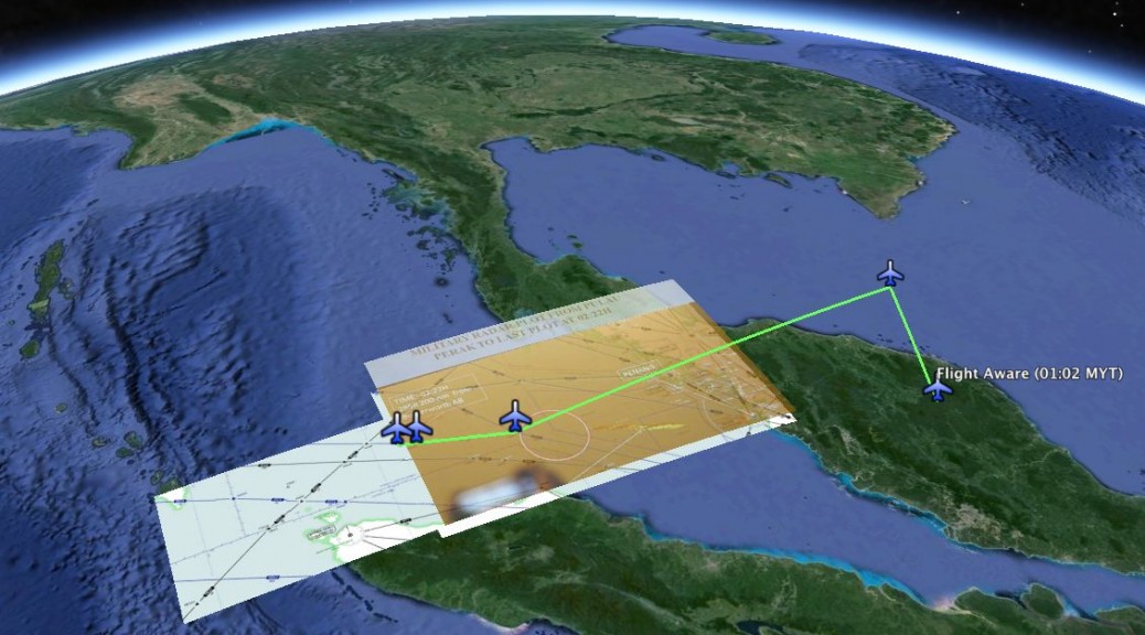
ORIGINAL POST: We now have one more official source of information to go on: Via Twitter, a photo, shown to Chinese media in Beijing on March 21, of a Malaysian military radar image showing MH370, pinpointing its last plot at 02:22 MYT (UTC+8):
To analyse the image properly, I took a screenshot of the same area from SkyVector‘s amazing aeronautical charts, overlaid and aligned that SkyVector screenshot onto Google Earth, then overlaid and aligned the photo of the radar image onto the SkyVector screenshot, then annotated the SkyVector screenshot as precisely as possible, in order to position the last known plot accurately in Google Earth.
Here is the resulting KMZ file for you to use. (Open it in Google Earth, then select individual elements and play with the opacity slider in the sidebar to compare alignments.)
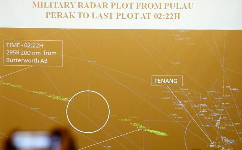
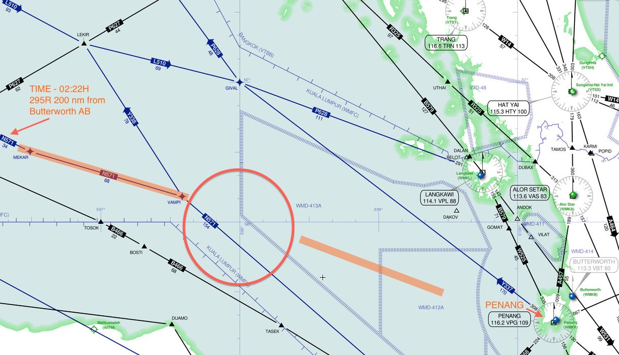
This allows us to draw some interesting inferences. But first, the data: Here is the SkyVector screenshot of the same area (annotated by me, click to enlarge):
Some analysis:
The radar image is not unambiguous, at least not without additional official context. But it does label a specific place at a specific time: MH370, at 02:22 MYT, at or even beyond the MEKAR waypoint. The green trace “line” to the left of the annotated circle connects the VAMPI waypoint (previously named as a waypoint for MH370) to MEKAR. A route from IGARI on the other side of the Malaysian peninsula to VAMPI and then on to MEKAR would be a straighter route than the previously mooted one, which had MH370 turn a sharp right at VAMPI to GIVAL — a turn of more than 90 degrees — which always looked somewhat odd. (If these waypoints sound confusing to you, do read this post for context.)
One thing that aligning the photo with the SkyVector screenshot lets us do is notice that the green “line” and the annotation arrow extends slightly beyond MEKAR. If so, MH370 was on its way to NILAM — where its path would have crossed route P627, which skirts past the northern edge of Sumatra and into the Indian Ocean in a WSW direction. The last known bearing of MH370 is thus far less suggestive of a northerly route.
If we now connect the dots, from the position at 01:02 MYT as plotted by FlightAware, to IGARI, to VAMPI and then on to just past MEKAR at 02:22 MYT, we get a distance of roughly 1090km (see the KMZ file to check), flown in 80 minutes. That’s a speed of 820km/h, approximately, which is feasible.
What about that circle annotation in the photograph and the green “line” to the right? Absent an official account from the press conference, here’s my take: The circle is meant to highlight empty space, and thus show that the two green lines are two separate tracks from 2 separate planes. That would also explain the second arrow annotation on the right, which presumably leads to a label for another plane. Note too that these two green “lines” have slightly different bearings. But if anyone has an official clarification, I would love to hear it.
UPDATE: Keith Ledgerwood was able to convince me, with images not in the public domain, that the second arrow notation referred to the same track. So there are no two planes.
UPDATE March 22 22:37 UTC: I’ve found the original image on a Chinese media website. I’ve edited the post above to reflect this. Unfortunately, the caption doesn’t provide much in additional context. Here it is via Google Translate.
As it seems, both the traces are for the same aircraft. (Please note the title, “Plot *from* Pulau Perak to”). The color of the plot (green) may indicate a ‘friendly exit’ as described in the Chinese note.
The circle may just indicate a RADAR blind spot?
Yes, that is also possible.
There is indeed a radar blind spot from Butterworth caused by high mountains in the north of Penang Island. I checked the radar tracks of aircraft from 17:22 to 17:40 UTC and only MH30 flew west via VAMPI but much later than 17:40 UTC. Cargo plane DHL779 flew from Penang to GIVAL in the right time frame.
For MH370 to fly from IGARI to west of Penang in 7 minutes required a flight at Mach 3, faster than Concorde. Yeah sure…
Who can we contact at GOOGLE EARTH that is responsible for getting current satellite photos of the South Indan Ocean to get some current photos of the airports in the Xstans?
My proposition:
https://imageshack.com/i/0kj06zj
https://imageshack.com/i/nr5w1kj
well, ok, but why make complex maneuvers avoiding radar systems to head later to nowhere?
Looks like you were right, Amizaur.
Transponder codes can and are changed in flight. It could have been changed to a 7500, 7600, or 7700 code. The code could have been changed to a value misunderstood from Vietnamese air traffic control.
http://en.wikipedia.org/wiki/Transponder_(aviation)
http://www.nst.com.my/nation/general/font-color-red-missing-mh370-font-pilot-i-established-contact-with-plane-1.503464
Stefan,
I am curious to know what your opinion is regarding the radar data shown to the families that Keith Ledgerwood claims was showing flights other than flight 370.
Where do you stand now?
Thank you.
Anyone have a clear idea on altitude changes? Would love to know at what points in the course the plane went to extreme altitudes (high/low)
My two cents, the goal was Perth via the Cocos but realistically never had a chance.
The image shown to relatives at the Lido Hotel is a hoax. Malaysia claims this was from the screen of a Thales Raytheon GM400, however the display of a GM400 has a black background not orange and looks nothing like the official image:
http://i257.photobucket.com/albums/hh212/727Kiwi/ThalesGM400radarscreen_zps0d84b907.jpg
The background in the Malaysian image has all the details from an airways chart such as waypoints, tracks & TMAs. This means it is taken from the screen of an SSR radar and the phosphor trail if real has to be from an aircraft with its transponder switched on. We know MH370 did not have its transponder switched on, therefore the image is a hoax.
Another point is were that aircraft track created by MH370, then the tracks of UAE343 and SIA68 are entirely missing.
http://i257.photobucket.com/albums/hh212/727Kiwi/MH370/UAE343Overlay_zps49d145d2.jpg
Finally Malaysia claims MH370 was also seen by Thai radar at Surat Thani, however that is also a hoax.
http://i257.photobucket.com/albums/hh212/727Kiwi/MH370/SuratThaniradar133nmradius_zps8078ddac.jpg
Surat Thani with an elevation of 20 feet has a maximum range of 200nm. Kota Bharu is 240nm away. More importantly if the radar was powerful enough to see that far MH370 would have to be flying at 37,000ft, or higher.
Malaysia claims MH370 was seen on radar diving west from IGARI and also claims it was flown like fighter plane at 5,000ft.
The radar horizon from Surat Thani for an aircraft at 5,000ft is 92nm
Neither Butterworth nor Thai radar saw MH370 and all the evidence supporting this is untruthful.