Is Google showing India’s Assam state as part of China? (No.)

The border between China and India is contested in many places, and is a matter of prickly national pride for both countries — the month-long Sino-Indian War in 1962 was triggered by an escalation of a border skirmish on the northern edge of the present-day Indian state of Arunachal Pradesh, a large part of which China insists belongs to Tibet. In that war, China quickly advanced to its claim line on the southern edge of Himalayan foothills, where the line skirts the Brahmaputra river plain. Having met little resistance from the Indian army, China then unilaterally retreated to the pre-war line of control, approximately the McMahon Line, possibly because winter was looming. China’s claim remains, however — and the border has since been the topic of much fraught bilateral negotiation.

Not surprisingly, mapping the China-India border has proven something of a thankless task for Google. Both China and India prohibit the publication of maps that do not draw their respective official claim lines as the ground truth, so Google has created three distinct Google Maps datasets — one for the Chinese market at ditu.google.cn that shows the area north of the claim line as unambiguously Chinese, one for Indian users at google.co.in/maps that shows the border along the McMahon Line, and one reference set for the rest of the world at maps.google.com which shows the area as disputed; this is also the dataset used in Google Earth.

Google has on two occasions (in 2007 and in 2009) messed up its depiction of the area around Arunachal Pradesh, and each time India’s media was outraged at Google’s perceived nefarious conspiracy to undermine Indian sovereignty, when in fact the error was an honest mistake that Google quickly rectified. Still, India’s media now keeps an eagle eye on Google’s depiction of its border.

That eye once again saw cause for complaint when the the northeastern Indian local paper Seven Sisters Post this Monday ran the story — on its front page, above the fold — that Google Earth is now showing parts of the neighboring Indian state of Assam as being claimed by China:
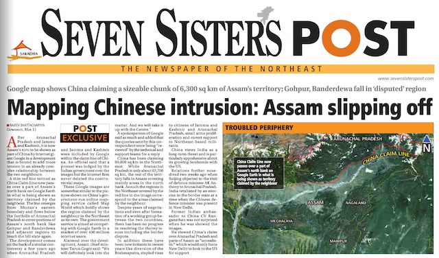
This story was subsequently taken up by other Indian media outlets, where the headline soon read: “Google shows Assam as part of China”.

What happened? If the papers had kept to watching Google’s India-facing map dataset, they’d have nothing to complain about — it still shows India’s borders in conformity with Indian law. But Seven Sisters Post went looking on Google Earth, which shows both the Chinese and Indian claim lines for that section of the border.

That Chinese claim line is not, in fact, identical to the internal border between Arunachal Pradesh and its neighbor, Assam. In the region close to Bhutan, China has since before the 1962 war claimed an area beyond Arunachal Pradesh in Assam. Close to Burma, there is a large part of Arunachal Pradesh that China does not claim. The divergence is visible on this map:
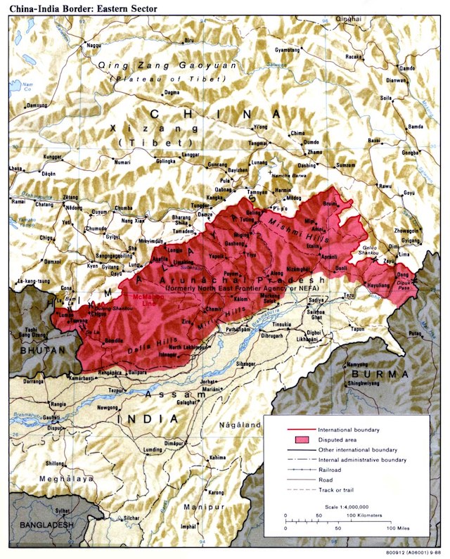
As recently as 2009, Google Earth still showed the Chinese claim line near Bhutan as equivalent to the internal border between Arunachal Pradesh and Assam. (Note the jagged indentations of that borderline.)

apge2009.jpg

That depiction was not, in fact, correct. At some point since then, possibly quite recently, a more accurate representation of the claim line was added, though at a far coarser resolution than the internal state borders or the McMahon Line that depicts India’s claim.

On the international version of Google Maps, both the internal border and the Chinese claim line are visible. Here is the map near Bhutan, with the short dotted lines depicting the Chinese claim line and the longer dotted lines the internal border between Assam and Arunachal Pradesh; the solid line is the border with Bhutan:


View Larger Map

On Google Earth, however, something is gone from the dataset: The internal border between Assam and Arunachal Pradesh is missing when it runs to the north of China’s claim line:
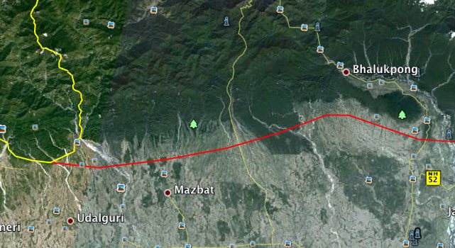

Screenshot from Google Earth on 13 March 2012

Why is it missing, and since when? I don’t know, but I assume the representation on Google Earth is a mistake that will soon be rectified, because Google has long argued that more — and more accurate — information in the pursuit of context is always better. Here is the relevant policy statement from December 2009:

We work to provide as much discoverable information as possible so that users can make their own judgments about geopolitical disputes. That can mean providing multiple claim lines (e.g. the Syrian and Israeli lines in the Golan Heights), multiple names (e.g. two names separated by a slash: “Londonderry / Derry”), or clickable political annotations with short descriptions of the issues (e.g. the annotation for “Arunachal Pradesh,” currently in Google Earth only […])

This annotation makes clear that Arunachal Pradesh is wholly administered by India. I’m adding it here for the sake of completeness:

Arunachal Pradesh (Hindi: अरुणाचल प्रदेश Aruṇācal Pradeś) is administered by the Indian government as the easternmost state on India’s northeast frontier; Itanagar is the capital of the state. Meanwhile, it is also claimed by the People’s Republic of China as an integral part of its territory, as a part of South Tibet (Zangnan 藏南) and integral with the Chinese prefectures of Ngari, Shannan and Nyingchi. The dispute originates with the 1913 establishment of the McMahon Line which divided British-controlled India from Tibet; however China did not recognise the line’s authority. After India became independent in 1947 and the PRC was established with full control over Tibet, India asserted the McMahon Line as the India-China boundary in 1951 and forced Tibetan authorities to withdraw from the area. During the Sino-Indian war of 1962, China recaptured most of Arunachal Pradesh (then called the North East Frontier Agency or NEFA) but voluntarily withdrew back to the Line of Actual Control (LAC) in 1963 which approximates the McMahon Line’s location. Indian and Chinese forces clashed in the region in 1986-87, but the countries signed agreements in 1993 and 1996 to respect the LAC. Despite several attempts to reconcile, including discussions as recent as January 2008, India and China remain in dispute over this territory.

How do other online maps fare? OpenStreetMap draws the International border as India would have it, with no sign of China’s claim line. Microsoft’s Bing Maps, on the other hand, has China claiming a much larger area than on Google Maps, with the claim line even crossing the Brahmaputra river at one point:
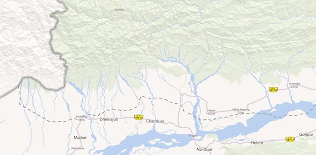

(Note, you need to zoom in to see this border. if you zoom out, the map reverts to a more vague border that approximates the internal border between Assam and Arunachal Pradesh.)

In addition to showing the border between Assam and Arunachal Pradesh, could Google Earth be even more complete in its depiction of the region? Yes, by drawing an orange Line of Control between China and India along the McMahon Line, just as it does for the de facto border between India and Pakistan in Kashmir. This would make it clearer that the region is administered by India, which matters, as possession is a great advantage in territorial disputes.
The last days of old Kashgar — an update

In August 2010, I visited Kashgar, a city in China’s remote far west that for over a millenium helped drive the Silk Route economy, inheriting an old town with distinctive Islamic architecture. My visit was compelled by the news that this old town was in the process of being dismantled by authorities, so I wanted to see it before it was gone. I ended up spending a week documenting and mapping the process, publishing the results in a Google Earth file.

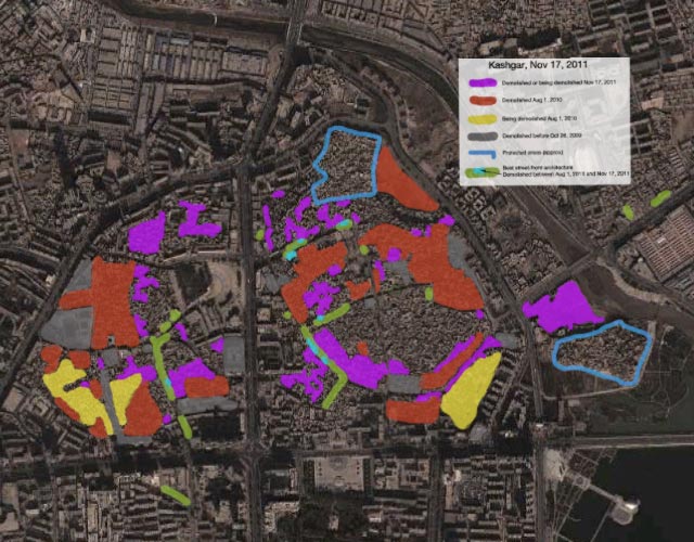
On February 17, 2012, new imagery of Kashgar appeared in Google Earth, taken just three months ago, on Nov 17, 2011. By comparing this new imagery to the older imagery and my notes, I’ve been able to update the map to chart the progress of the old town’s transformation in the 15 months between my visit and the latest imagery. Here it is as a Google Earth file:

Some observations from studying this new imagery:

  • Around two thirds of the old city has now been demolished, up from almost half 18 months ago. The goal still appears to be to demolish 85% — there are two designated protected areas that are slated to remain untouched.
  • The new satellite imagery does not show wide open spaces where demolished houses once stood. That is because the building of new structures starts almost immediately as old houses are demolished. The best way to look for rebuilt areas is to compare before-and-after structures, which often include construction that does not yet have a roof.
  • Some good news: The rebuilt structures by and large appear to be of the same scope and size as the ones they are replacing — there are no further encroachments of large modern tower blocks on the old city core (so far). It also looks like no new larger roads are intersecting the rebuilt areas, though it does seem from Google Earth that new alleys are not being redrawn along old routes (but it is hard to tell).
  • Some bad news: Some of the street-facing architecture that I marked on the map as being distinctive when I visited — for the verandas or traditional workshop fronts — appears to have been demolished. I’ve marked these areas in light blue on the map. I was hoping these parts of town would be left alone, or restored, rather than demolished, as they were especially worth saving.
  • In demolished areas, some isolated original structures are allowed to remain, and new construction is built around them. This points to some flexibility on the part of authorities. Perhaps some instances of authentic courtyard houses will manage to survive intact, even in the areas slated for demolition.

Google conspiring for regime change in Syria through maps? Hardly.

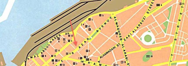
For autocratic regimes, naming landmarks is both a perk and a tool — a cheap stab at immortality and a means to cement authority: In Syria, examples abound: The main highway through Damascus is named after the late despot Hafez al-Assad, father to the current one. In the coastal town of Latakia, a main street is called 8 Azar Avenue, named after the March 8, 1963 coup d’état that brought the Ba’ath Party to power, soon headed by the al-Assad clan. (March = Azar = آذار)

Should the al-Assad dynasty fall in Syria, these names will certainly change. In the meantime, how do reference maps depict such landmarks? Taking Latakia as an example, here’s a conventional, static tourist map found online:

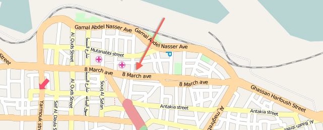
Here’s the crowd-sourced OpenStreetMap:

(Neither Bing nor Yahoo Maps has street-level data. MapQuest uses OpenStreetMap’s.)

How about Google Maps and Earth?

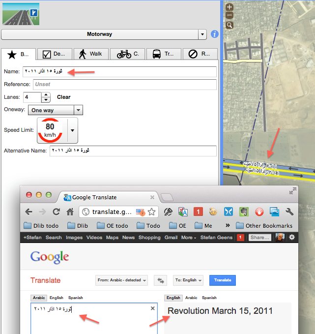
What’s going on here? Israeli news site Arutz Sheva flags an article in Syria’s Damas Post (translation), dated Friday, January 6, 2012, which first noticed that a new name “15 Azar” had been added to Google’s maps. The reference is to March 15, 2011, when mass protests erupted in Daraa, launching the present uprising in Syria.
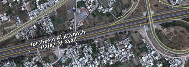
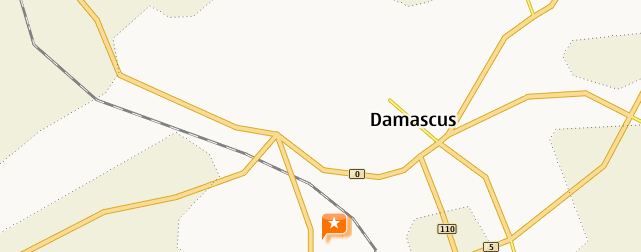
In Damascus, the Hafez al-Assad highway shows up in Google Earth with two names:

Who is Ibrahim al-Kashosh? At the start of the uprising, he penned popular songs mocking Bashar al-Assad, admonishing him to leave power. He was later found dead in a river with his vocal cords ripped out.

What’s unusual in these two examples is that the names exist as part of Google’s official place name dataset — in previous cases, such apparently rogue names had been attributed to contributions in third-party content layers. The Damas Post uses this observation to construct an elaborate conspiracy theory involving the Egyptian Google employee and activist Wael Ghonim, whom it accuses of promoting a pro-western agenda in collusion with the US through “the implementation of the theory of creative chaos”. The surreptitious renaming of streets is meant to be an example of such “creative chaos”.

That is of course not what happened, through the truth also carries interesting implications. For a few years now, Google’s been crowd-sourcing map making in those regions for which no good online reference datasets exist, in competition with OpenStreetMap. Google’s tool, Map maker, lets any user add or edit streets, placemarks, and names, with a review system in place to catch errors:

The first time a Map Maker user makes edits to a map, the edits may require review and approval before the edits will be published. Once a Map Maker user has made a few approved edits, most of the subsequent edits will go live automatically. However, some types of edits or edits in specific regions will always require review, regardless of how experienced the mapper is. In addition, some edits may require multiple reviews before the edits appear on Google Maps.

There is no need for Google or the US to engage in creative chaos: It would be enough for some enterprising opponents of the al-Assad regime to get some of their edits past unwitting reviewers for these name changes to make it onto Google Maps and Earth.

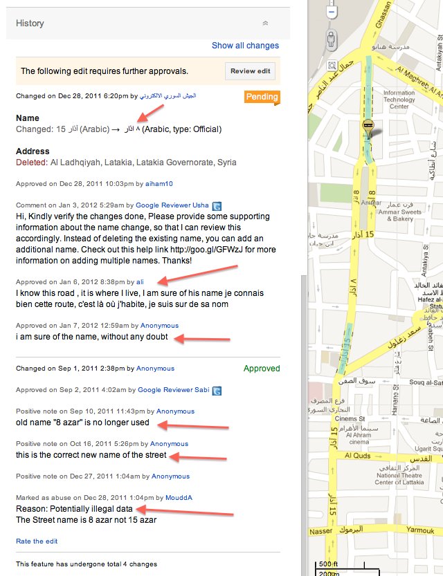
And that is exactly what seems to have happened: Currently pending edits in Latakia and Damascus betray the tail end of an edit-war that seems to have been playing itself out. Here’s the situation in Latakia today:

What we’re seeing is a request to have the street name changed back to March 8. Below it is the edit history, which shows that the name change to March 15 was promoted by several anonymous users in the past few months.

In Damascus, the current name for the disputed highway on Map Maker and on Google Maps is not the same as what you see on Google Earth. Both “Hafez Al Asad” and “Ibraheem Al Kashosh” have been replaced by the more neutral-sounding “Southern Bypass” / “Mothalik Aljanobi” / “المتحلق الجنوبي”:

But if you begin searching for Ibrahim’s name in Map Maker, his name is autosuggested, though without returning a result — indicating that the name did exist on the map, but not any longer:

The edit history also shows that Hafez al Assad’s name on the highway was replaced by the existing “Southern bypass” by a moderator on December 14, 2011. (Click on the history tab on the bottom of the linked page above to see for yourself.)

Since Google Earth’s dataset of place names is updated less frequently that Google Maps, what we’re likely seeing in Google Earth is an earlier snapshot of an edit war that was eventually resolved in a truce: Neither the name preferred by the regime nor the one by its opponents stayed; instead a neutral descriptive name was chosen. Unless Google intervenes in this case, expect Google Earth to have the highway labelled as “Southern Bypass” / “Mothalik al-Janobi” / “المتحلق الجنوبي” soon enough.

So is Google the only mapping provider susceptible to this latest innovation in guerrilla mapmaking? No. In fact, OpenStreetMap has been hacked in exactly the same way, and on the very same highway:

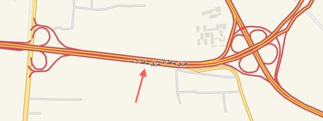
In OpenStreetMap, the highway is currently named after March 15, 2011, the same revolutionary date we saw in Latakia. MapQuest, which periodically imports OpenStreetMap data for its map of Syria, still names the highway after Hafez al-Assad (on a barely legible map):

Unless OpenStreetMap does any further edits to this item in its dataset, MapQuest too will soon have a renamed highway on its map.

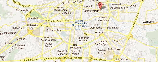
Are there any far-reaching implications to the fact that OpenStreetMap and Google Map Maker are susceptible to political hacks? I don’t thinks so; it’s a challenge that Wikipedia has long dealt with, and the problem can be minimized, if not completely eradicated, by alert moderation. And if the alternative to crowd-sourced maps of places like Syria is no online maps at all, then the overall advantages far outweigh the occasional blip. This is the Yahoo Map for Damascus today:

Which, when you compare it to a crowd-sourced map at the same scale, manages to be both devoid of information and fictitious:

I’ll take Google Maps or OpenStreetMap any day, the occasional hiccup notwithstanding. (That said, I would not stake my life on Wikipedia, Google Maps or OpenStreetMap, not without first crosschecking sources.)

Iran missile base post-explosion imagery, now hi-res in Google Earth

On November 12, a powerful explosion ripped through an Iranian missile base on the outskirts of the town of Bīdgeneh, 40 km west of Tehran. As the Guardian reported soon after, among the dead at the base was the architect of Iran’s missile program, Major General Hassan Moghaddam. There has been heavy media speculation the explosion might have been the result of a covert operation by Israel’s Mossad.

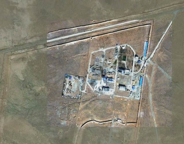
Post-explosion satellite imagery has now become available that shows the extent of the destruction. Commissioned by the Institute for Science and International Security (ISIS), the imagery was taken on November 22, 2011. ISIS Senior Research Analyst Paul Brannan has published the annotated image along with the most recent available imagery from before the explosion, taken September 9, 2011. He adds:

ISIS learned that the blast occurred as Iran had achieved a major milestone in the development of a new missile. Iran was apparently performing a volatile procedure involving a missile engine at the site when the blast occurred.

You can’t tell from the imagery if sabotage caused the explosion, but you can tell the damage was extensive, wiping out most structures at the base. The NYT elicits more commentary from Paul Brannan in an interview.

Because ISIS’s web post and accompanying PDF used lower-resolution versions of the Nov 22 image, I asked ISIS for the original high-resolution image, to overlay on Google Earth. The September 9 imagery is already in Google Earth’s base layer, so it was just a matter of overlaying the one new image. Here is the resulting KMZ file, containing the high-resolution original, ready to open in Google Earth.

In Google Earth 6 and above, remember to click on the opacity button in the sidebar and then play with the opacity slider to switch between the before- and after- imagery. For reference, the sports court at the base is 30×15 meters, about the size of a basketball court.

P.S. On November 28, an new explosion ripped through what appears to be a uranium conversion plant near Isfahan, rattling windows in the city. Speculation is mounting (some based on intelligence sources) that Iran’s nuclear and missile programs are being systematically sabotaged or attacked. In 2010, the Stuxnet worm caused heavy damage to the uranium enrichment facility at Natanz.

In Slovenia, photography gets regulatory scrutiny

Over at Dliberation, I’ve reported on a story with a geolocation twist likely of interest to Ogle Earth readers:

In an unfortunate bout of regulatory innovation in Slovenia, the information commissioner there has decided that panoramic photography benefits from less legal protection than conventional photography because she reckons panoramas make it is easy to tell where the photograph was taken, and when, thus compromising the data rights of the people in the shot. She argues this, apparently unaware that all modern digital photography comes with EXIF time stamps which sites such as Flickr will automatically share, while many smart phone camera apps will attach their location to photos published to Twitter or Facebook. Photographs of landmarks also situate individuals at a certain place at a certain time. The commissioner may have unwittingly condemned all such photography to Street-Viewesque blurring requirements — at least if she is consistent in her logic.

I “blame” Google for this:

[This is] a case study of how Google, by voluntarily implementing facial blurring in its relatively new but hugely popular Street View automated 360-degree panoramas, created norms in the minds of regulators that they are now eager to set in stone legally.

Because Street View is so popular, it is quite possibly the only kind of immersive panorama that most people have seen. I believe this has altered popular expectations regarding the blurring of individual faces, which led to the commissioner decreeing that all panoramas not depicting a news-worthy event need to be blurred. Ironically, Google Street View isn’t even available in Slovenia:

That’s because Slovenia said it would require Google to keep the raw Street View images in Slovenia until they were blurred — no unblurred images were allowed to leave the country. Because the blurring makes use of Google’s servers, none of which are in Slovenia, Google respectfully declined to add Slovenia to its Street View program.

Read the whole article over at Dliberation.org.

Announcing Dliberation.org

In case you wonder what else I get up to, in terms of my interests: I’ve started Dliberation.org, a blog about the global social and political impact of digital networks. What Ogle Earth is to digital atlases, Dliberation is to digital networks — so yes, it is a lot less niched, but in line with how my interests have developed these past few years. Ogle Earth continues to be the place where I report on how Google Earth affects science and society; for a broader look at Internet regulation, censorship, surveillance, activism and cybercrime, visit Dliberation.org. Here’s the inaugural post, about a new research center for the Internet and Society, situated in Berlin and funded by Google. I hope you enjoy reading it as much as I will enjoy writing it.

Hunting illegal mining in Goa

There is a juicy scandal unfolding in India’s smallest and richest state, Goa, where the State Assembly’s Public Accounts Committee (PAC) has prepared a report indicting ruling Congress Party politicians for benefiting from illegal mining in the state. Illegal mining is estimated (by the Hindustan Times) to have cost Goa over USD 600 million over the past five years in lost tax revenues, turning this into a whopper of a story.

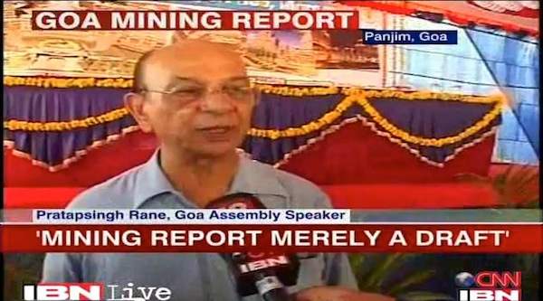
Reporters are having a field day with the clumsy ways in which local Congress Party bigwigs have maneuvered to derail the report. Congress Party members on the PAC committee refused to sign the report, but that didn’t deter the chairman of the committee, Manohar Parrikar, from submitting the report to the State Assembly. The (Congress-affiliated) speaker of the Assembly, Pratapsingh Rane, then refused to table the report, on account that it is “merely a draft”:

On October 8 Rane sacked Parrikar, who also happens to be the leader of the opposition, from his role as chairman of the PAC committee. Parrikar then vowed to release the findings to the public, “using government documents and records that are in the public domain,” reports the Hindustan Times.

Part of those public domain records are from Google Earth, The Economic Times reports:

According to highly placed sources, the PAC has based its findings against [Congress Party leader Dinar] Tarcar on the satellite images procured by the Google [Earth] tool.

The mine operated by Tarcar through Power of Attorney at Temebocheo Dongor in rural Goa (survey number 59/51) has been found to have extracted several million tons of ore. […]

“The Google pictures of 2003 clearly show that the area was a virgin land and it is not possible to agree with any fallacious contention that several million tons of ore dump accumulated has been done on account of earlier dumps accumulation,” the report mentioned.

India’s national Directorate of Mines and Geology has now also taken an interest in the mine, ordering it to immediately cease production until it is investigated. An article by Goa’s Herald spells it out for us:

Tarcar has cheated the government by avoiding huge amounts of export duty by under-invoicing of his exports.

When presented with evidence of massive ore dumps that could not have been produced within quota, his mining company contended that these were from earlier activities. Google Earth’s imagery from 2003 effectively catches the company in a lie.

So: Where is Temebocheo Dongor in Goa, and is there an mine there that didn’t exist in 2003?

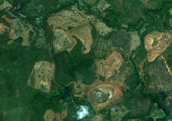
Browsing Goa’s hinterland with Google Earth, you’ll find it riddled with open-pit mines — mining is the second largest industry in Goa, after tourism.

Two pieces of information allow us to pinpoint a strong candidate for the mine in question. The first is that we know there has to be imagery of the mine from 2003 in Google Earth. About two thirds of Goa satisfies that criteria.

The second piece of information comes from the Herald article, which points out that the mine is “at Caurem and Maina.”

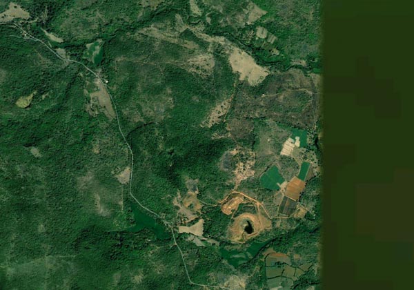
Those places are easily found in Google Earth via search. Once there, turn on historical imagery, and voilà, here is the closest high-resolution imagery available from 2003, taken on Feb 10 of that year, showing virgin lands and an embryo of a mine:

Versus the current view, from March 27, 2011:

If you want to see the historical imagery yourself, here is the KML pointer to it in Google Earth. Or have a look for yourself in Google Maps:


View Larger Map

Absent verification on the ground, we can’t be 100% certain that this is the Temebocheo Dongor mine, but it sure looks to be a strong candidate.

Notes on the political, social and scientific impact of networked digital maps and geospatial imagery, with a special focus on Google Earth.