[Update 2009-09-10: Aruchanal Pradesh’s placenames are now back to normal in Google Maps.]
China and India are two of the globe’s most touchy countries when it comes to how their borders are depicted on unofficial maps — in fact, in both countries it is illegal to publish maps where the borders deviate from official “guidance”. This makes the border between India and China quite interesting, especially as large chunks of it are disputed.
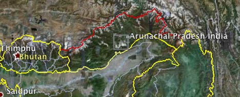
There is a pleasing symmetry to these disputes: In the west, Aksai Chin is claimed by India but administered by China. To the east, most of Arunachal Pradesh is claimed by China but administered by India. These are huge territories, so you might think there is plenty of room for a negotiated compromise — and you’d be right; just this Friday China and India sat down for yet another round of talks — their thirteenth, in fact. Differences are “narrowing”, according to Reuters.
In the past few days, Ogle Earth began receiving a surge of Google Search-referred visits from Indian IP addresses to older posts about Arunachal Pradesh, mostly on variations of searches for “Arunachal Pradesh Google”. Google had previously made an error regarding that region’s disputed border in Google Earth, but had fixed it quickly. Has Google now messed up again, at a particularly sensitive moment in time?
In a word, Yes. Indian bloggers and media this past Thursday noticed that many place names in Arunachal Pradesh had turned Chinese in Google Maps, depicted both in Chinese characters and their Anglicized equivalent. For example: Around Tawang, home to the famous Buddhist monastery near the Bhutanese border, place names are now written like this:
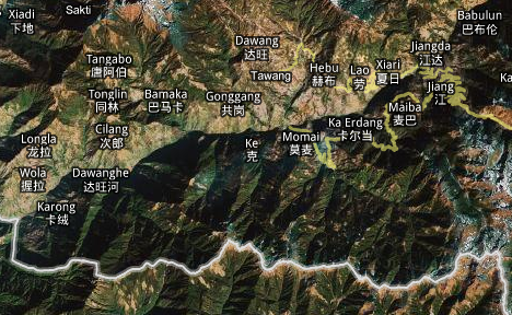
All place names north of China’s claim line are depicted thus. Place names to the South are mostly in Hindi, with an Anglicized equivalent:
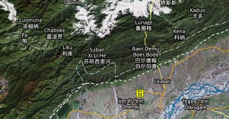
Those are indeed aberrant depictions of place names, if Google intends to be neutral about a region administered by India but claimed by China. (Place names in Aksai Chin are in Chinese, for example.) And sure enough, Indian bloggers, reporters and even politicians were not particularly inclined to give Google the benefit of the doubt, not 24 hours before the start of those “high-stakes” border talks. Times of India quotes one MP:
”This is shocking. How could Google change the names of places of a sovereign country without the country’s knowledge?” fumed Congress’s West Arunachal MP Takam Sanjoy.
Etc.
But then Google reacted. To their credit, they quickly admitted to a mistake in a statement released to the media and republished by many Indian media sites on Saturday:
Earlier this week, as part of a routine update to Google Earth, we published new data for the Arunachal Pradesh region that changed the depiction of certain place names in the product. The change was a result of a mistake in our processing of new map data. We are in the process of reverting the data to its previous state, and expect the change to be visible in the product shortly. We would like to clarify that this issue did not impact our depiction of international borders.
(A quick fact check: It wasn’t place names in Google Earth that were affected — they still depict only Anglicized versions of Hindi names. It’s in Google Maps that the error occurred. Google Earth does show some user-generated Panoramio photo icon labels in Chinese in Arunachal Pradesh, but there is nothing wrong with Panoramio users writing in their own language.)
Someone identifying themselves as an employee of Perfect Relations, India’s self-described largest PR firm, even posted the above statement “on behalf” of Google in the comments section of one of the Ogle Earth posts currently receiving all that Google Search traffic. This seems to be a new strategy, aimed at quickly quenching any budding outrage in the (Indian) blogosphere, by taking the conversation to the blogs themselves.
Now it is just a matter of waiting until the names are corrected. But will that end the outrage? The problem is that when those Indian bloggers and journalists went looking on Google Maps, they also noticed that both the Indian and Chinese claim lines for Arunachal Pradesh are drawn in dotted lines. Neither is given the prominence of a national border, and Google does not play favorites, just as it doesn’t with Aksai Chin, where borders are also drawn in dotted lines.
In Google Earth, disputed national boundaries are perhaps even more clearly demarcated, as a red line instead of a yellow line, and annotated as well:
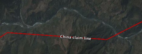
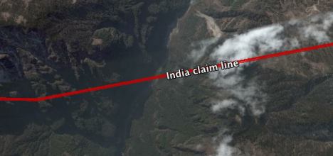
This is, of course, as it should be. National borders in Google Earth that are not bilaterally agreed to are in red, no matter how tenuous the claim. Good luck telling that to the rabid fringe among India’s bloggers though — and I’m pretty sure that is why Google’s statement contains the preëmptively plaintive line, “We would like to clarify that this issue did not impact our depiction of international borders.”
Google’s policy regarding disputed borders has, however, progressed since late 2007, when it last made a cartographical error in the region. Here is how Arunachal Pradesh’s border looked when Google made that mistake in early November 2007:
And here it is after it was corrected, in November 2007:
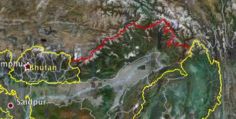
For at least the last few months, however, Google has been showing both claim lines:

Additionally, “lines of control”, such as the one between India and Pakistan in Kashmir, are in orange. I approve, because I am for more information, not less. Even if you don’t agree with the validity of a certain claim line or de facto control line, you should at least want to know where that line is. Maps that don’t depict such information for political reasons do their users a great disservice.
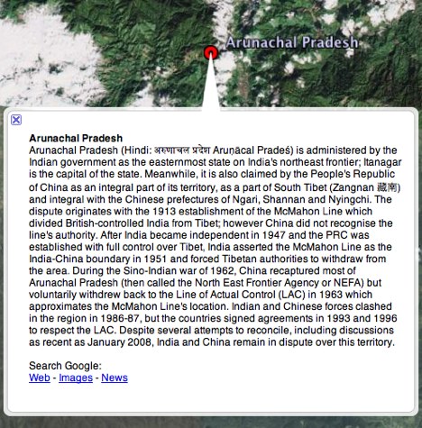
And Google can’t be faulted for not trying to bring as much nuance and context as possible to its maps. Here is the popup box for the main place name of Arunachal Pradesh in Google Earth:
One final question: How might an error like this have happened? Google in fact maintains two sets of Google Maps databases: One for the proper internet, and one for users in China. This latter map does depict Arunachal Pradesh as being integral to China, and with identical Chinese names as the one that accidentally populated the global Google Maps. (For example, Tawang on ditu.google.cn vs Tawang on maps.google.com).
The reason for the Chinese Google Maps is simple — Google serves them from Chinese servers, which are subject to Chinese law, and it would be illegal for Google’s Chinese business unit to depict Arunachal Pradesh in any other way. And somehow, data intended for the China map must have ended up in the global map. (It would be interesting to know how:-)
Could India demand a Google Maps for Indian users that depicts the world’s borders as India’s government decrees them? Google Maps isn’t served from inside India, because India doesn’t indulge in anything as offensive as censorious China’s great firewall, so the short answer is No, unless India’s politicians were to change the law and start making life difficult for Google’s Indian business units. [Update 14:47 UTC: Scrap that. maps.google.co.in shows both Aksai Chin and Arunachal Pradesh as being integral to India. I guess that map is served from inside India and/or Indian politicians have already gotten their way. But on the Indian Google Map, too, placenames are Chinese both in Arunachal Pradesh and Aksai Chin.]
(Just to be clear: You can currently access maps.google.com and Google Earth from China, but only at the pleasure of China’s censors, and with a performance hit due to the great bottleneck that is the great firewall.)
I always wondered what those red lines were .. Thank you for that complete answer !
china is bullying corporates to modify India map.poor India is targetted by the cancerous countries neighbouring it except nepal and bhutan.Bharat Mata Ki Jai!
Thank you for the info. I appreciate the load of information posted here. I love Google, it’s just simply good. – Thanks !
Indian Bloggers should take this matter seriously and urge Govt of India to react in a proper way otherwise use media’s help in giving a hard whip to politicians in power and do something for good.Every Indian who loves this country should feel enraged and react and put an end to this drama played by politicians since independence. Be hard on them and teach them a lesson.
It is socking and very disturbing for Indians as china is claiming our whole state and our government have also start giving some reaction till date.
This is good at Google have admitted the mistakes and i am sure the map will be edited by Google map team within near future.
The body of water south of Tallahassee, Florida is the Gulf of Mexico not the Atlantic Ocean
Ok, this may come a little bit late, but the Gulf of Mexico? Part of the Atlantic Ocean. A gulf it’s not a body of water, but a indentation of sea water on land. It denotates shape, just as a cape is the inverse. So, the name Atlantic Ocean is correctly used.
India has border disputes with most of its neighbors, such as Pakistan and Nepal. Just because the British drew border-lines for India without consent from bordering countries and India signs it does not mean it is fact. Perhaps at that time the British wanted to exploit further or felt sorry for being masters of Indians.
How much land does china want?Seriously,if chinese claim based on some Chinese kingdoms ruleover a certain region means its chinese,then whole of south asia should be Indias as indian kingdoms ruled much of them for a considerableamount of time.If ur not aggressive,u will be thrown out of ur own house!Its high time Indians Be aggressive in these matters!!
What about European place names for the lands of the Indigenous Peoples?
FREE US!
FREE Canada!
FREE Australia!
FREE New Zealand!
Being a Arunachalee i felt that if suppose china own the Arunachal Pradesh by any means, the result will be same as Tibet.Chinese are not interested on us, they need only land and how can they empowered there country.They just one to show the world that they are King of Asia. But what about Indian Government, they are already expense lots of money for Development of the Arunachal Pradesh, But our Ministers instead of Patriotism, they are just full there pockets from Central,so where is the development? be frank even I don’t know where is our future,either in India being a useless MAN or in China being as a SLAVE