China’s nail houses, in geospatial context

Kashgar, 2010, by Stefan Geens

China is not the first place to see massive building projects wipe out organic urban geographies, but the scale and pace of the current transformation is unprecedented. Some recent projects have nabbed the headlines — the Olympics in Beijing, the Shanghai World Expo, the transmogrification of Kashgar — but hundreds of lesser-known cities are seeing similar levels of change.

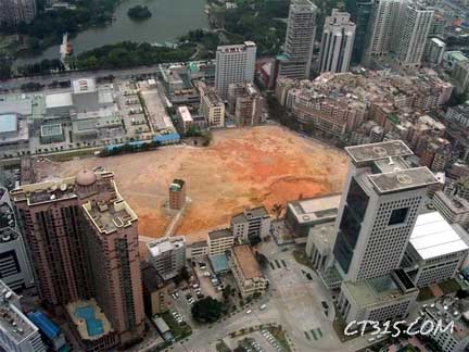
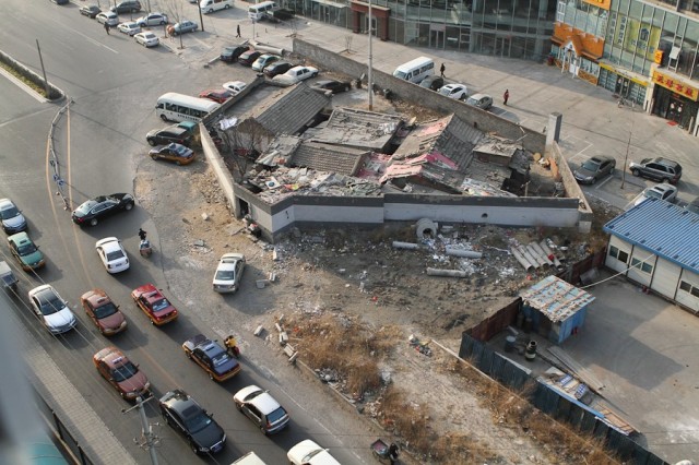
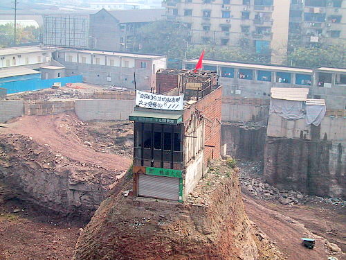
Every so often, the master plans of developers don’t align with those of an existing home owner. The negotiations, coaxing and intimidation that follow can reach absurd levels, while surrounding buildings and utilities are removed. The remaining “nail house” (钉子户, dīngzi hù) fittingly reifies the defiance of its owner, but in the end, the lone holdout almost never proves a match against the unstoppable forces of dialectical materialism.

Nail houses captivate us — and not just because of the good visuals or the underdog empathies they arouse. They are a rip in the space-time continuum to a counterfactual world, where China’s vernacular architecture is ceded a place. For as long as they hold out, nail houses are waypoints to the past, standing askance against the all-too straight lines of futurism with Chinese characteristics.

I spent some time this past weekend hunting down some of the more famous nail houses, and collecting them into a KML file for download, ready to open in Google Earth. Google Earth’s database of historical imagery provides a unique time-lapse tool for peering at China’s ongoing urban reinvention, and it’s allowed me to positively identify the locations of seven well-known nail houses, including the most recent one in Wenling. In some cases, Google Earth has historical imagery showing the nail house in situ; in other cases, you only see the before– or after view.

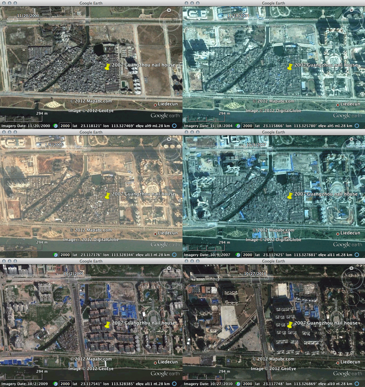
When visiting each of these nail houses in Google Earth, play with the historical imagery timeline in the top toolbar to visualize the progression of the surrounding development over the past 10 years or so. The historical imagery is not available in Google Maps or on other mapping services, so you need to use Google Earth for this.

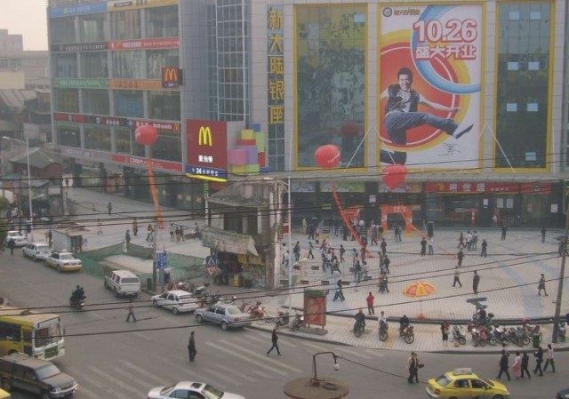
To whet your appetite, here are the nail houses in question, sometimes with associated geospatial context:

Chongqing, 2007 (population 29 million): This was the first nail house to gain international recognition. In Google Earth you can clearly see that until 2003 at least, the location was a very centrally located “snacking” street with food stalls.

Shenzhen, 2007 (population 10 million): Turn on 3D buildings to find this nail house underneath one of the world’s tallest buildings, the Kingkey 100, completed in 2011.

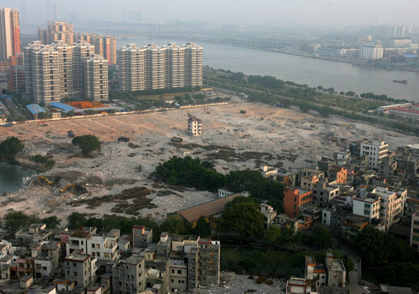
Guangzhou, 2007 (population 13 million): Guangzhou has seen some amazingly rapid development along the Pearl River this past decade:

Here’s the view in 2007:

Changsha, 2008 (population 2 million):

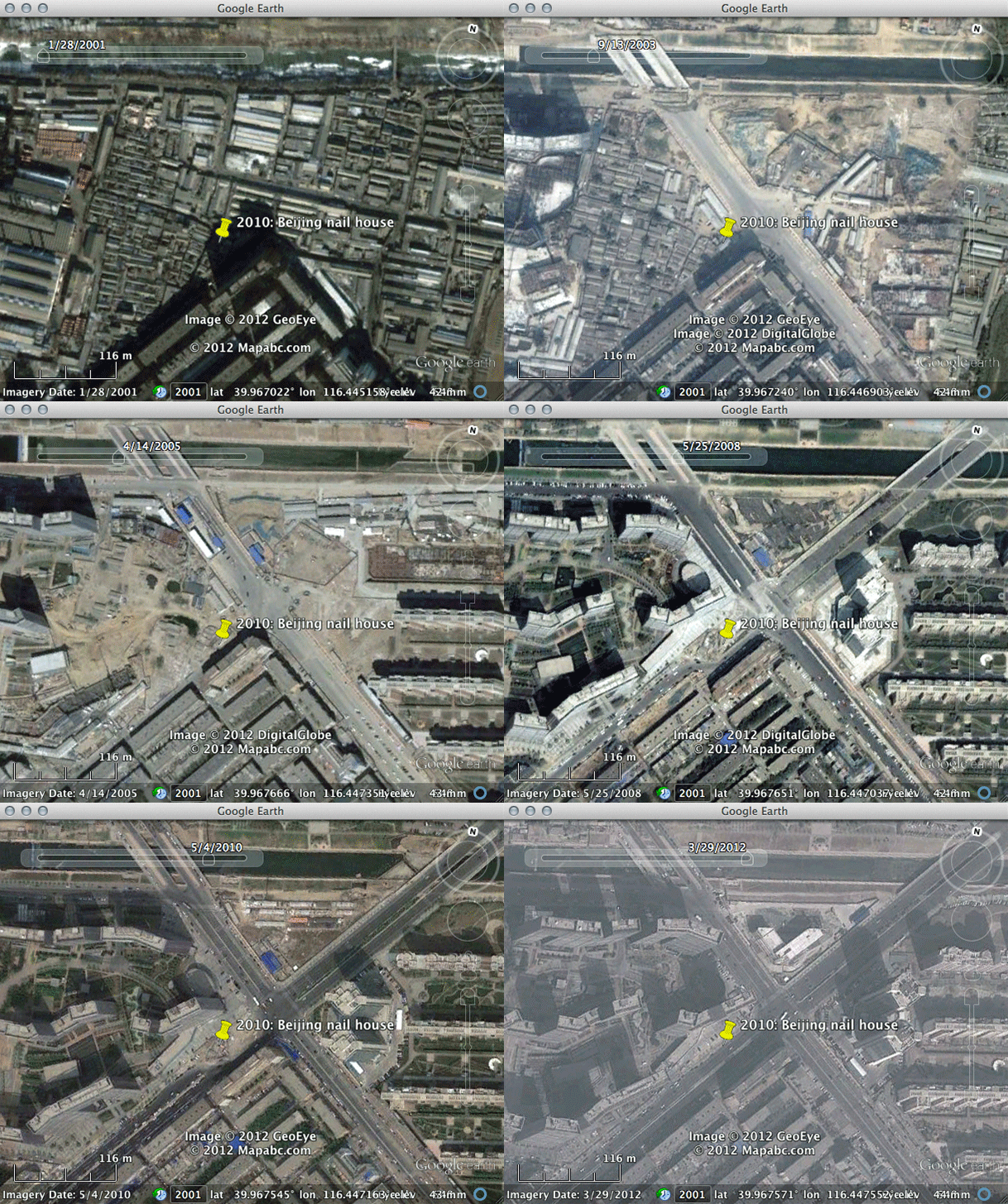
Beijing, 2010 (population 20 million):

Here’s how that particular place slowly turned into a nail house over the best part of a decade:

Kunming, 2010 (population 3 million):

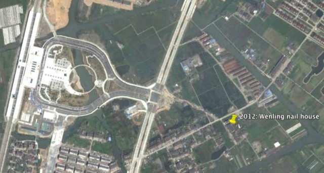
And finally, Wenling, 2012 (population 1.4 million):

In Google Earth, notice the recently built railway station to the West, but also the copious fields through which the road could conceivably have meandered. The road bisecting the nail house is not yet visible in Google Earth, as the most recent imagery there is currently from 2010.

There are other nail houses out there, but in several cases Google Earth’s imagery hasn’t yet caught up with recent news. If you find any yourself, let me know and I’ll add them to the collection.

Imagery of sectarian destruction In Burma’s Rakhine state now on Google Earth

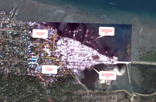
In Burma’s Rakhine state, a long-standing sectarian conflict between the Rohingya Muslim minority and the Rakhine Buddhist majority has recently escalated: In the last few days, the western coastal town of Kyauk Pyu saw an entire Rohingya neighborhood destroyed, satellite imagery acquired by Human Rights Watch shows.

HRW’s analysis of the imagery is available as a PDF, but not as an overlay onto Google Earth, so I extracted the imagery and made one myself. Here it is as a KMZ file, ready to download and open in Google Earth.

The file contains two overlays: Digital Globe imagery of the neighborhood before its destruction taken on March 9, 2012, and imagery taken just after the destruction, on the morning of October 25, 2012. According to HRW, the area was razed on October 24. The current imagery in Google Earth’s default later is from December 20, 2009.

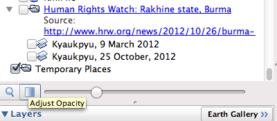
As usual, the best way to explore these overlays is to turn on one or both, and then to play with the opacity slider, so that you can quickly compare the imagery from 2009, March 2012 and from just a few days ago:

In Google Earth, the new imagery gains a lot of context — not just in terms of the size of the area that has been razed, but also by situating the imagery inside the Burmese state, whose isolation until recently still means the area is terra incognita to most. In Google Earth, meanwhile, the Panoramio layer boasts several photos from the immediate vicinity of the destruction — such as this one, by B. Bavčević:

Apple Maps and the Diaoyu/Senkaku islands

Much fun has been had at Apple’s expense this past week over the half-baked mapping product it released with iOS 6. The main benefactor has been the Google Maps team, whose painstaking work and years of experience are no longer in danger of being taken for granted. Publishing digital maps that “just work” is proving to be a lot more difficult than most realized, with The Atlantic and TechCrunch pitching in to tell that story.

As Internet serendipity dictates, the Apple Maps blowback meme soon crossed another meme — the flare-up in the ongoing territorial dispute over the Senkaku/Diaoyu islands, with China, Taiwan and Japan all claiming sovereignty. First, there was the (incorrect) rumor doing the rounds in Beijing that Apple Maps had taken sides:


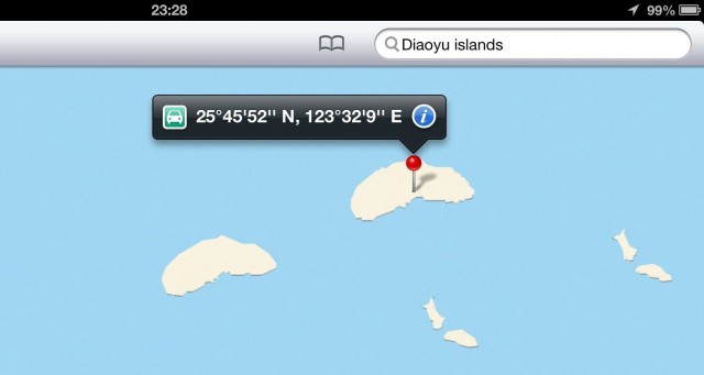
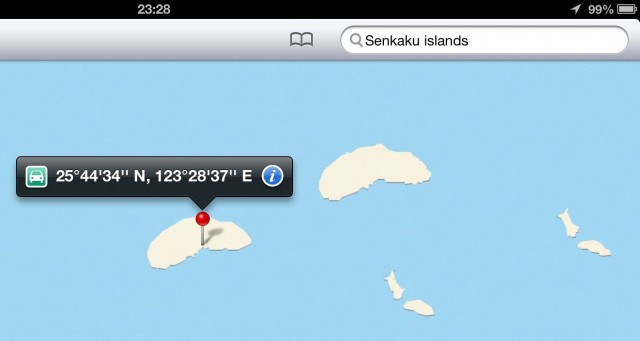
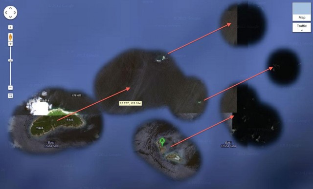
Upon closer inspection, it became apparent that while there are no labels or borders depicted near the islands, the islands themselves are rendered twice in the map view of Apple Maps — with a search for “Senkaku Islands” dropping a pin on one set of islands, and a search for “Diaoyu Islands” dropping a pin on the other:

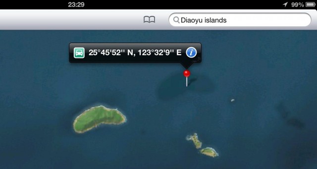
When viewed in satellite view, the island labeled by the Diaoyu search disappears:

How does Google Earth/Maps stack up against Apple’s efforts?

First, there is clear evidence that Google also grappled with raw data containing a duplicate set of islands. Zoom in close enough in the satellite view and you see that the non-satellite seafloor dataset makes room for satellite imagery in a repeated, transposed pattern along a NE/SW axis, separated by the same margin of error that separates Apple Maps’ islands:

It’s fair to conclude that Google ran the seafloor masking algorithm before any human map error correction. In this case, the result is just some extra satellite imagery of island-less — but not completely empty — ocean: Just at the edge of the mask we see what I assume is a Japanese patrol vessel plowing full-steam ahead towards the islands, in an image captured on July 30, 2009.

In Google Maps’ map view, meanwhile, there is just one set of islands represented — the southwesterly one, as this is where georeferenced satellite imagery actually places the islands. This implies that at some point, a human was involved in noticing and correcting the duplication.

In Google Earth, turning on historical imagery removes the seafloor mask, so you can see the satellite image tiles in their entirety. One nearby tile alerts us to the presence of an outlying islet some 100km east of the main group; Google’s masking algorithm doesn’t quite pick it up. It is therefore invisible in the satellite view of Google Maps, and in Apple Maps too.

How might the duplicated islands have come about? Close inspection in Apple Maps (on an iPad — Apple’s maps are mobile only) reveals that the datasets are not identical; the contours of the islands are drawn differently. They thus come from different sources. And while all mapping data sources can contain one-off errors, officially sanctioned maps of China are all offset spatially by a variable amount in a ham-fisted attempt at thwarting GPS-based georeferencing by mere civilians.

My strong suspicion, then, is that the duplicate island belongs to an intentionally inaccurate Chinese dataset. There is some irony in that.

When it comes to labels, Google approaches the dispute in a typically Googley way: In Google Maps (though not in Google Earth, curiously), we get more information, not less:

The islands are named in both Japanese and Chinese. In Japanese, the islands are labeled 尖閣諸島 (Senkaku-shotō, or “Senkaku group of islands”); in Chinese, they are called 钓鱼诸岛 (Diàoyúqúndǎo, or “Diaoyu group of islands”). Individual island names are also labeled in both languages.

This approach to disputes is similar to Google’s dual labeling of the Persian/Arabian Gulf and the East Sea/Sea of Japan, though it is a policy that is at times applied haphazardly: For a similar dispute between Korea and Japan over the Liancourt rocks, Google Maps stays mute while Google Earth gets an expository popup label. And Google doesn’t currently label the Senkaku/Diaoyu islands with a Roman alphabet, which makes it difficult for most Google Maps users to comprehend, unless they have the third-party Panoramio photo layer turned on.)

Finally, a few more observations re Apple Maps that don’t quite fit anywhere else:

  • For the user interface fanatics that Apple engineers clearly are, the two-fingered navigation of Apple Maps in 3D mode is far less intuitive that for the iPhone’s Google Earth app. The latter is far better at guessing whether I want to tilt the view, rotate or zoom.
  • When using iOS 6 within China’s great firewall, Apple Maps’ satellite view only shows imagery of China, with the rest of the world blacked out:

Image courtesy of The Next Web

I’m intrigued by the technical “solution” behind this behavior: One likelihood is that Apple’s servers check the iOS device’s geolocated IP address before deciding which imagery dataset to send it. Google, in contrast, quarantines its country-specific datasets behind separate URLs (maps.google.co.in, maps.google.kr…), leaving the choice of dataset up to consumers, with governments free to block URLs from their citizens if they dare.

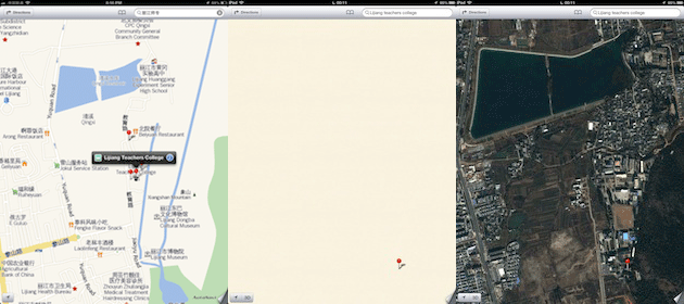
As a corollary, the Chinese Maps dataset provided to Apple by its Chinese provider is not available globally, but only to users inside China. If you repeat China resident Anthony Drendel’s search in Apple Maps for “Lijiang Teachers College” outside China, you get a different view:


From left to right: Drendel’s map view of the teachers’ college from inside China, my map view from outside China and my satellite view from outside China.

It is possible that Apple’s solution does not require a conspiratorial collaboration with the Chinese authorities. As the logo in the bottom right of Drendel’s screenshot shows, his dataset is provided by Autonavi, a company specializing in Chinese mapping data only. Maybe Apple simply hasn’t had the time or the legal license to properly mash together Autonavi’s dataset with Apple’s global dataset, including Tomtom’s. A lack of time would also explain the duplication of the Diaoyu/Senkaku islands.

[Update 2012/09/26: A post on the Wall Street Journal Digits blog today appears to confirm that a lack of time prevented the integration of the Chinese and global datasets, quoting a source:

Integrating the two would take time due to a number of complexities, which include integrating map search databases and coding, a person familiar with the matter said.]

Apple censors iPad Maps app over South Korea

While re-reading my previous post on an iPad today, I discovered some odd behavior on the iPad’s Maps app: When zooming in on satellite imagery of South Korea, the app prevents close zooms in the same manner as Google’s maps.google.co.kr, even though the app serves Google’s reference content from maps.google.com. This constraint does not exist when accessing maps.google.com via Safari for iPad, the new Chrome for iPad or Google Earth for iPad, which leads me to conclude that Apple has decided to hobble its Maps app globally when it comes to viewing satellite imagery of South Korea. I suspect this is because Apple sells iPads in South Korea with the Maps app included, turning it into a purveyor of South Korean maps, and thus responsible for compliance with the South Korean laws mentioned in the previous post.

Specifically, the area in which close zooming is prevented is a rectangular box between 125º and 130º East longitude, 34º and 38º45′ North latitude (not 39º, as that would bisect Pyongyang, which would presumably have made people wonder what’s going on.) Here it is embedded on Google Maps:


View Apple iPad Maps app zoom restriction for South Korea in a larger map

Surprisingly, this bounding box does not actually cleanly encompass South Korea. The large South Korean island of Jeju lies completely outside this perimeter, as well as some other small islands hugging South Korea’s southern coastline. (Does this mean Apple is still in technical breach of the relevant South Korean law?) Meanwhile, the large Japanese island of Tsushima lies completely inside the perimeter, and is thus censored in equal measure as the rest of South Korea. (maps.google.co.kr accurately censors Jeju but not Tsushima.)

Apple’s action contrasts with Google’s because Apple has let its compliance with a local law “bleed” into its global product — my iPad bought in Sweden. It is also in contrast to previous Apple actions, which saw it offer a special non-GPS iPhone in Egypt, a special non-wifi iPhone in China, and a special hard-wired mapping solution that only allowed maps.google.cn content to display on iPhones sold in China. Perhaps South Korea is not large enough a market to qualify for its own specially hobbled product; or perhaps Apple has changed its approach, and is now more willing to apply local censorship demands globally. It will be very interesting to track Apple’s responses to the censorship demands Google has faced down when its mapping service goes live in iOS 6.

Constraining online maps: The case of South Korea

If you are a web-based service provider and don’t have operations in a specific country, then that country’s laws cannot constrain the services you provide to users there. If Bahrain were to decide it doesn’t like Google’s maps, it could try to block the relevant URLs wholesale, but it has no legal recourse to compel Google to censor its maps. That’s because there are no Googlers, Google servers, or Google Street View cars in Bahrain.

But with Google’s global operations now having expanded to over 40 countries, far more countries are able to regulate the services Google provides locally. And when it comes to mapping and location-based services, some of them most definitely do.

Over the years, China and India have been the two main countries tracked on this blog for authoritarian tendencies when it comes to borders, names and third-party content. Because of the size of these two markets, Google has generally acquiesced to the legal restrictions governing locally published web maps, but has always made sure to contain the damage to the datasets aimed at these countries. Local users have always had recourse to the unmolested content served from outside the country — the reference content of maps.google.com and Google Earth.

Recently, it has become apparent that South Korea has also been placing constraints on what maps.google.co.kr is allowed to show. Because South Korea’s laws are easily accessible, this makes for an interesting case study in how Google tries to accommodate local laws in its local services without compromising the integrity of its global dataset.

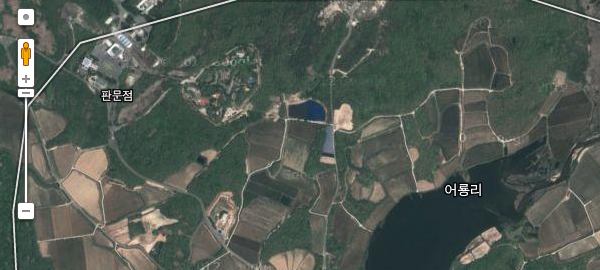
The main way in which maps.google.co.kr differs from maps.google.com is the maximum zoom level available for the satellite view of Korea, which maxes out at a far lower resolution than for the global map. On maps.google.co.kr, the furthest you can zoom into Korea is this: (Click to go to these locations on the relevant maps)

On maps.google.com, you can zoom in a further three steps.

On Google Earth, of course, you can zoom in as far as the DigitalGlobe imagery will bear.

Why is Google’s Korean map behaving this way? In short, because of Korea’s Spatial Data Industry Promotion Act from 2009, specifically Article 7, which states that:

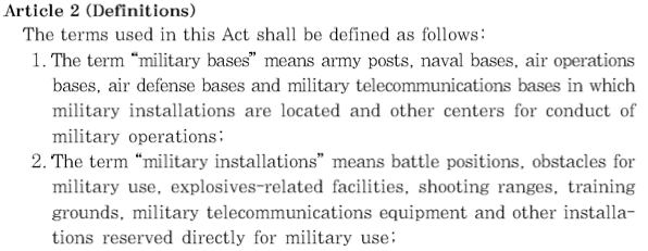
Spatial data business operators may produce and distribute any processed spatial data. In such cases, processed spatial data shall not include any spatial data on any military base provided for in subparagraph 1 of Article 2 of the Protection of Military Bases and Installations Act nor on any military installation provided for in subparagraph 2 of the said Article.

Article 2 of the Protection of Military Bases and Installations Act, in turn, explains that:

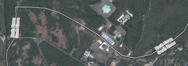
And considering the existence of the most heavily militarized border on the planet between North Korea and South Korea, this means a substantial part of South Korea is riddled with military installations.

By limiting the maximum resolution of its Korean imagery on maps.google.co.kr, Google appears to have satisfied Korean regulators that it is obeying the relevant Korean laws. Thus, Google avoids having to blur or otherwise censor the satellite imagery base layer for Korea — something which it has successfully managed to avoid in China, India and elsewhere.

When it comes to road and point-of-interest data, the datasets for maps.google.com and maps.google.co.kr appear to be identical translations, probably because the data is locally sourced. This would explain why large areas near the border remain unmapped, and military installations remain unlabeled. Many of these installations on both sides of the border are labeled in Google Earth by third-party contributors, however.

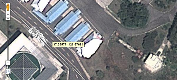
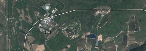
There is one final quirk to how Google delivers map information about Korea. When viewing satellite imagery in maps.google.com, you can zoom in on a highly accurate rendition of the Military Demarcation Line (MDL), which indicates exactly where the front was when the armistice agreement was signed in 1953.

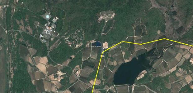
A far more vague MDL is depicted on maps.google.co.kr and in the map view of maps.google.com, which is strange, considering that we can assume the North Koreans know exactly where the line is:

Google Earth also carries the vague version of the line, but additionally displaces it by around 500-1000 meters to the east.

I’m putting this down to a glitch, however. You can always load up on Korean War maps as a KMZ file for Google Earth.

How does Google’s Korean map compare to the local competitor, local.daum.net? When zooming in on satellite imagery with Daum, at a certain point the border region becomes completely blacked out, putting Google Maps at a relative advantage there.

For satellite imagery outside of the immediate border region, however, Daum lets you zoom in far closer than on Google’s Korean map, without any further apparent limitations, though the imagery is in all likelihood censored to obfuscate military installations, something which Google has always said it is unwilling to do. Its depiction of the DML is equally vague as on maps.google.co.kr.

Daum also offers historical satellite imagery of South Korea in its web-based map — something which Google only offers in Google Earth — and even historical Street View imagery of Korea, which is something Google doesn’t offer anywhere (yet?).

The big picture
It is apparent (to this non-lawyer) that in containing online censorship to within the legal jurisdiction of the country making the demand, Google (and Twitter and Tumblr) are hoping to build a legal norm. Their solution may well satisfy the letter of the law, but it does not really satisfy the intent, because in the networked age locally censored content is always available uncensored on another domain, in this case also controlled by Google. It would be ridiculous, for example, for sensitive sites in India to be redacted if they remain readily visible on Google Maps in Pakistan. In the same way, it is pointless for a British court to enforce a super-injunction by only demanding that Twitter remove an offending Tweet from the UK version of the Twitter stream, considering how easy Twitter makes it to circumvent the block. (I approve, of course.)

The risk is always there, though, that a country might decide to innovate its legal approach so as to punish Google or Twitter locally for a refusal by global HQ to resort to censorship globally. It’s not unthinkable, as this recent report on extraterritorial jurisdiction from Harvard’s Kennedy School of Government makes clear:

While states tend not to assert criminal jurisdiction over foreign companies directly, they do make use of a range of parent-based methods of regulation (i.e. domestic measures with extraterritorial implications) under which a parent company may be held criminally responsible for contributions to the crimes of others, including the foreign conduct of foreign actors, or failures to ensure compliance by those over which it is able to exercise control. [p.142]

There are many subtle ways a state can retaliate against local operations. Just ask Google’s Chinese operations. The one big deterrent would be the promise of a robust retaliation from the US government in terms of trade policy.

Update 20120702: Also see my follow-up post on how Apple censors satellite imagery of South Korea in its iPad Maps app.

Why do Panasonic, Leica, FujiFilm, Samsung and Nikon censor their GPS cameras?

In 2008, mainstream camera manufacturers began introducing models with built-in GPS receivers, to automatically add location metadata to photographs. Since then, 10 brands have released a total of 41 distinct models of GPS-enabled cameras. You can find most of them in DPReview’s filterable database.

When the GPS-capable Panasonic Lumix TS4 launched in early 2012, GPS Tracklog’s Rich Owings noticed a strange footnote in the press release:

GPS may not work in China or in the border regions of countries neighboring China.

Rich and I pondered aloud on Twitter as to how in-camera GPS receivers could possibly break when used in China. There is nothing wrong with GPS in China, as anyone who has successfully flown there can attest. Tens of millions of Chinese-bought iPhones have access to highly accurate latitude and longitude readings via Apple’s default compass app, which uses assisted GPS. (I just had a friend in Shanghai read me her coordinates over Skype and confirmed her position in Google Earth.) So why would Panasonic choose to hobble its GPS-enabled cameras so that the location data is withheld from users whenever that location is deemed by the firmware to be in China?

One mooted reason was a Chinese law prohibiting mapmaking and surveying without a license. Foreigners logging location coordinates via GPS while travelling near sensitive sites have been detained on these grounds. In 2010, Chinese authorities cracked down on user-generated mapping, aka neogeography, citing security risks. And in a continuing sign of this trend, just last week a prominent Chinese state TV anchor used his microblog to rail against “foreign spies who find a Chinese girl to shack up with while they make a living compiling intelligence reports, posing as tourists in order to do mapping surveys and improve GPS data for Japan, South Korea, the United States and Europe.”

A tweeted response from Panasonic PR confirmed a legal motivation for the technical restriction:

Despite follow-up questions no more information was forthcoming, beyond the suggestion that we check the manual for details.

This left many questions unanswered. Why would a Japanese manufacturer selling a camera in the US and Europe be so eager to ensure that its customers obey a (dubious) Chinese law? What is a Lumix TS4 owner supposed to do if she receives permission to log GPS coordinates in China? What happens if the law changes so that permission is no longer required? How did Panasonic end up second-guessing what customers should or should not do in China?

One possibility is that Panasonic believes its customers would sue if they got arrested for inadvertently logging location data while travelling around China. But then why not allow a manual override for informed and/or authorized users?

Perhaps Panasonic fears a near-future dystopian scenario where GPS-enabled cameras are confiscated by Chinese border guards if they are at all able to log data inside China. But surely, with an average product life-cycle of one year, that’s not a big risk?

Maybe Panasonic decided it would be too expensive to release both a China-compliant model and an unmolested global model — and so decided to just release the China-compliant model globally, having taken note of the size and growth of the Chinese consumer camera market.

Or maybe the GPS chip in the camera is manufactured in China, and thus needs to meet some kind of Chinese security restriction before it gets an export license. Admittedly, my scenarios are getting somewhat farfetched.

In the absence of good answers, I let the story languish a few months, hoping to find someone in the camera or GNSS industry able to confirm both the why and the how of the Lumix TS4’s curious behavior when inside China.

Unable to get any more clarity on the matter, I recently decided to check the manuals of all 41 models across all 10 mainstream brands, to see if others besides Panasonic admit to interfering with the GPS function of their cameras for political reasons. It turns out that five of the 10 brands do.

Panasonic, Leica and FujiFilm prevent their cameras from displaying location information when in China. Nikon and Samsung appear to restrict location information in some other way. Sony, Canon, Pentax, Casio and Olympus do not interfere with the GPS function of their cameras when in China (or at the very least do not admit to it in their manuals).

Here’s the assembled evidence — relevant excerpts from all the manuals of all the GPS-enabled cameras sold since 2008. First, the culprits:

Panasonic:
Lumix DMC-ZS7 (Jan 2010)
Lumix DMC-ZS10 (Jan 2011)
Lumix DMC-TS3 (Jan 2011)
All these cameras’ manuals have an explanation like this:
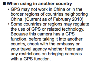
Surprise: All three of Panasonic’s GPS-capable predecessors to the Lumix TS4 cripple GPS use inside China, ever since 2010. We only noticed in 2012 because the TS4 press release mentioned it (and no, I don’t have a habit of reading manuals of cameras I don’t own:-).

In addition, all three cameras have a ready-made error message for when the camera has decided to conceal its location: “GPS FEATURE IS NOT AVAILABLE IN THIS REGION.”

Lumix DMC-TS4 (Jan 2012)
The manual for the TS4 is not yet available on the web, but the official website makes clear about what happens to these cameras when in China:

Lumix DMC-ZS20 (Jan 2012)
Same goes for this camera:

Leica:
Because Leica’s V-Lux cameras are rebranded Panasonic Lumixes, we get an opportunity to see how two different marketing departments describe the same technical limitation. Leica, it turns out, is far more articulate about how and why their cameras are crippled:

V-Lux 20 (Apr 2010) (a rebranded Lumix ZS7)

This in addition to the same error messages as on the Lumix ZS7. (So much for Panasonic trying to be coy in its manuals.)

V-Lux 30 (May 2011) (a rebranded Lumix ZS10)

V-Lux 40 (May 2012) (a rebranded Lumix ZS20)
The V-Lux 40’s manual is identical to that of the older Lumix ZS7 and ZS10 when it comes to describing GPS limitations (see above).

FujiFilm:
FinePix F550 EXR (Jan 2011)
FinePix XP30 (Jan 2011)
FinePix F600 EXR (Aug 2011)
FinePix F770 EXR (Jan 2012)
FinePix XP150 (Jan 2012)
All FinePix cameras carry this disclaimer:

Nikon:
Nikon seems schizophrenic about its approach to GPS:

Coolpix P6000 (Aug 2008)
One of the very first compacts on the market to have built-in GPS, this camera’s manual makes no mention of GPS restrictions or China. This is how it should be. Nikon’s GP-1 GPS unit for its DSLRs also makes no mention of restrictions.

Coolpix AW100 (Aug 2011)
Coolpix S9300 (Feb 2012)
Coolpix P510 (Feb 2012)
By 2011, however, Nikon’s cameras warn that “GPS may not function properly” in and around China:
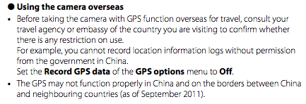
On a Nikon website, A user shares his experience using GPS with his Coolpix AW100 in China:

The GPS in my Lumix [TZ10] camera is disabled when in China. The camera gives an information message that it disables the GPS while in China. I was pleasantly surprised that Nikon [Coolpix AW100] does not disable the GPS in China but places some limitations on its use. The locations using the GPS in China seem to be off by about 500 ft to the west. In addition, the map function does not work in China and there are not location points for China in the database. I found it interesting that while I was in Southern China, several miles from Hong Kong, the camera would like the closest location point in Hong Kong (which turned out to be a KCR metro station about 10km away. I am very glad the GPS works in China even with these limitations.

Samsung:
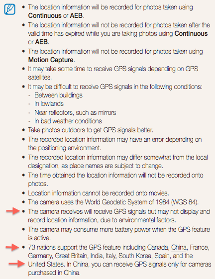
Samsung’s manuals, alas, border on the unintelligible. They are obviously transcribed from some other language:

ST1000 (Aug 2009)
HZ35W (Jan 2010)
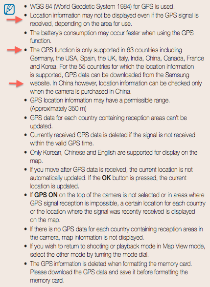
It is not clear at all where the GPS works, nor does it make any sense to only allow cameras purchased in China to receive GPS signals in China.

Discussing the GPS performance of the Samsung HZ35W may be academic, however — DPReview’s review says that the camera’s GPS function is “idiosyncratic at best, and at worst, non-functional”, with many users not being able to get it to work at all. (Maybe because it appears to work only in a minority of countries, as per the manual.) Meanwhile, Samsung has not come out with updates to its GPS cameras for over two years.

Next up, those manufacturers who do not second-guess their customers:

Sony:
Cyber-shot HX5 (Jan 2010)
SLT-A55 (Aug 2010)
Cyber-shot DSC-HX7V (Jan 2011)
Cyber-shot DSC-TX100V (Jan 2011)
Cyber-shot DSC-HX100V (Feb 2011)
Cyber-shot DSC-HX9V (Feb 2011)
SLT-A65 (Aug 2011)
SLT-A77 (Aug 2011)
Cyber-shot DSC-TX200V (Jan 2012)
Cyber-shot DSC-HX200V (Feb 2012)
Cyber-shot DSC-HX10V (Feb 2012)
Cyber-shot DSC-HX20V (Feb 2012)
Cyber-shot DSC-HX30V (Feb 2012)
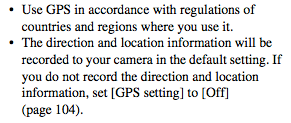
None of these camera manuals reference China in any way. All manuals carry the exact same text:
Canon:
PowerShot SX230 HS (Feb 2011)
PowerShot S100 (Sep 2011)
PowerShot SX260 HS (Feb 2012)
PowerShot D20 (Feb 2012)
None of these camera manuals reference China in any way. All manuals carry a version of this text:
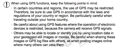
Additionally, Canon gets points for reminding users of potential privacy issues when geotagging photos.

Pentax:
Optio WG-1 GPS (Feb 2011)
Optio WG-2 GPS (Feb 2012)
The GPS utilities guide for these cameras carries an identical short reference:

Casio:
Exilim EX-H20G (Sep 2010)
The EX-H20G’s manual is perhaps the most straightforward of all:

Olympus:
Tough TG-810 (Mar 2011)

Tough TG-1 iHS (May 2012)
The manual is not up on the web yet, but the camera’s web page makes no mention of China or restrictions, and there is no reason to suspect a policy change since the TG-810.

Implications
Why does all this matter? Wherever local laws prohibit the sale or use of a personal electronics device able to perform a certain function, manufacturers have traditionally chosen not to sell the offending device in that particular jurisdiction, or — if the market is tempting enough — to sell a crippled model made especially for that jurisdiction.

For example, Nokia chose not to sell the N95 phone in Egypt when the sale of GPS-enabled devices there was illegal before 2009, whereas Apple opted to make and sell a special GPS-less iPhone 3G for that market. Early models of the Chinese iPhone 3GS lacked wifi, while the Chinese iPhone 4/4S has firmware restrictions on its Google Maps app.

The risk to consumers in freer countries is that personal electronics brands might be tempted to simplify their manufacturing processes by building just one device for the global market, catering to the lowest common denominator of freedom — especially if the more restrictive legal jurisdictions contain some of the most attractive markets, such as mainland China.

Still, in the absence of more information from Panasonic, Leica, FujiFilm, Nikon and Samsung, I can’t decisively say whether this is the business logic behind their decision to cripple the GPS in their cameras. And yet uncrippled GPS cameras from Sony and others are freely available for sale in China, for example on Taobao, China’s eBay:
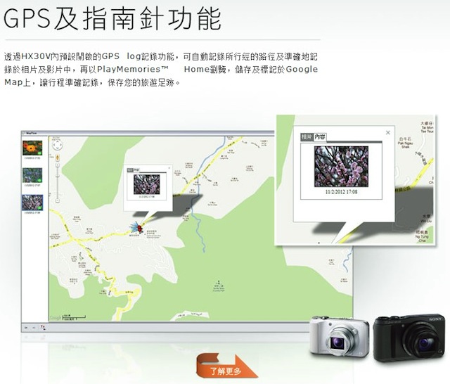
And Sony’s official mainland China site is more than happy to offer instructions in Chinese on how to use the GPS function.

Consumers in the market for a GPS-enabled camera should be informed that five of the mainstream brands engage in location-based censorship. Choose another brand, or get a dedicated handheld GPS device to sync tracklogs with your camera — I don’t suspect Garmin or Magellan will stop working in China anytime soon.

Google Earth conspiracy watch — Sri Lanka war edition

When this Oregon’s Salem News article crossed my radar screen, I felt it was a sufficiently over-the-top case of conspiracy mongering so that it did not merit a retort beyond a line of snark on Twitter.

Is Google Earth Hiding Sri Lanka’s Ghosts?

Tim King Salem-News.com

Google, are we misreading this? Haven’t Sri Lanka’s Tamils been through enough?

(SALEM) – Does Sri Lanka’s ongoing lack of transparency over its recent Genocide of Tamil people extend to Google Earth?

It’s disturbing. Google Earth appears to be be using an unusual series of photographs to comprise its image of Sri Lanka as the regime stands accused of war crimes in Geneva.

It’s a question that deserves to be asked; why is the exact area where so many were killed by government forces hard to make out, and why is that image specifically from 2005, years before the intense attacks on civilians in this area, while adjacent images are from May 2009, in the middle of the worst of the ethnic cleansing?

The number one online resource that people turn to for research should refuse censorship to any government that stands accused of grave violations of international laws regulating war, and crimes against humanity.

Etc. It goes on like that for many more paragraphs.

But then I noticed that others in my Twitter stream, people who generally know better, did not treat this story with the contempt it deserves:


So suddenly the narrative becomes: Why hasn’t Google posted satellite imagery of the endgame of the civil war in Sri Lanka on Google Earth — specifically from May 2009, when civilian refugee camps were bombarded by government troops. Is it callous negligence, or is Google somehow shielding Sri Lanka’s government from bad PR?

It shouldn’t come as a surprise that satellite imagery is available in Google Earth, and has been in one way or another since June 2009.

It was first available as a downloadable overlay within weeks of the events, created by Amnesty International and the American Association for the Advancement of Science (AAAS). (I know because I was involved in the production of one component of it — the aerial imagery popups.)

AAAS had asked the satellite imagery provider DigitalGlobe to take these images within the framework of their Scientific Responsibility, Human Rights and Law Program, which puts scientific resources to use to uncover and publicize human rights abuses, specifically through the use of satellite imagery. (The program has also highlighted abuses in Zimbabwe and Darfur.)

Then, sometime between 2009 and now, these DigitalGlobe images automatically became part of the Google Earth base layer — because Google’s contract with DigitalGlobe stipulates that all imagery take by its satellites ends up in Google Earth. (There are exceptions: Iraq and Afghanistan are not being updated due to the ongoing security situation there. Imagery of Israel and the Occupied Territories is reduced in resolution, as per US law. Overcast imagery is also rejected.)

So how does Salem News’s Tim King get to pen an article in such accusatory tones? If we rule out malicious intent, the only other explanation is ignorance of how Google Earth works, coupled to a conspiratorial mindset that prejudices Google.

The imagery that Tim King thought lacking is in fact part of the historical imagery dataset in Google Earth, and can be accessed by clicking the historical imagery button in the top button bar of the application. If he were to do this over the specific area where he complains the imagery is from 2005 (view in Google Earth here), he’d see imagery from May 27 2011, January 23, 2010, September 8 2009, and June 15, 2009, in addition to 2006 and 2005. In the areas immediately to the north, he’d find imagery from May 24, 2009.

Google doesn’t alway show the most recent imagery in the default layer; sometimes there is more recent imagery available in the historical layer. This is because the default layer is meant to be a reference layer, so older imagery that is clearer will sometimes trump more recent imagery containing clouds, long shadows or snow. The satellite- and aerial imagery used by Google Earth carries metadata such as cloud cover percentages, image resolution and acquisition date, and the resulting image mosaic uses this information to construct the “best” default snapshot of Earth.

When time-sensitive satellite imagery is taken in the immediate aftermath of humanitarian crises such as the Haiti quake or Hurricane Katrina, imagery is often cloudy, because the weather does not always cooperate and cloudy imagery is better than nothing. Google will include such imagery in its dataset, but it tends not to remain in the default view for long. In any case, the default dataset is reconstructed every time Google Earth has an imagery update — these days every two weeks or so — and newer imagery tends to crowd out older.

There is one final question to address: What if Google Earth had not had this data? Would Tim King’s complaint have been justified? Is it Google’s responsibility to commission satellite imagery itself every time it suspects some humanitarian disaster is in the offing? Google promotes the work of advocacy groups in support of human rights, as evinced by the Global Awareness layers available in the sidebar of Google Earth, and it also collaborates with DigitalGlobe and GeoEye in specific cases where getting time-sensitive satellite imagery to first responders via Google Earth will help the rescue. But Google should not be in the business of vetting every cause — that is the job at which the likes of Amnesty International and Human Rights Watch excel. Much better is for Google to focus on building an ever more accurate geospatial platform for the work of of such groups. And finally: Whenever a monitoring group commissions imagery from DigitalGlobe (such as what ISIS does when it monitors Iran’s nuclear program) that imagery ends up in Google Earth automatically, over time. Any cause can play, for a few thousand dollars.

Google Earth is a powerful transparency engine — so it is best to read the manual before penning embarrassing conspiracy theories that at best are a waste of the reader’s time, and at worst succeed in subverting initiatives that Google actually deserves praise for.

Notes on the political, social and scientific impact of networked digital maps and geospatial imagery, with a special focus on Google Earth.