Category Archives: Uncategorized

Hack alert: Terrorists don’t love Google

From a website that calls itself the Strategy Page, you’d expect an article about the security implications of Google Earth to be nuanced and knowledgeable. Instead, you get Why Terrorists Love Google, superficial drivel riddled with non-sequiturs. Some examples:

[Google] gathers together the largest collection of satellite photos ever…

Islamic terrorists are long on fanaticism, but short on practical skills.

Many countries have managed to persuade the satellite photo providers to lower the resolution of images showing sensitive areas.

This stuff is just made up, like a rookie blog post. As for the last quote, I am only aware of one country that has successfully lobbied the US to bar US companies from being the ones providing the highest-resolution commercial imagery of its territory: Israel. Does the unnamed author of the article care to name “many” more?

Nor does the article explain how time-delayed satellite images might be of use to terrorists. In fact, while we’re on the topic, here is why terrorists don’t love Google.

New satellite imagery of Iran’s nuclear sites – now on Google Earth

Via a Reuters report today, the Institute for Science and International Security (ISIS) has released new commercial imagery of Iran’s nuclear enrichment facilities taken by DigitalGlobe just a few weeks ago. The images are in a PDF report by Paul Brannan and David Albright, the latter an ex-UN arms inspector and nuclear proliferation expert. (ISIS, whose motto is “Employing science in the pursuit of international peace” has impeccable non-partisan credentials.)

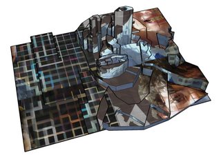
The PDF is fascinating, but the main images lack easy historical comparisons. Luckily, Google Earth already has very high resolution imagery of both the Natanz and Isfahan sites from a few years ago, also taken by DigitalGlobe. What I’ve done is repurpose the images from the PDF, which are annotated, as overlays on Google Earth, so that we can see the progress in the construction at both sites over the past few years.

Here is the KMZ file.

The best way to compare Google Earth’s base imagery with the overlays is to play with the transparency slider at the bottom of the Places panel.

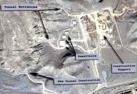
There are two sites covered. Isfahan is where uranium is first processed and where a storage facility is being built underneath a mountain. Here is what it looks like in Google Earth, from a few years ago:

isfa-goog.jpg

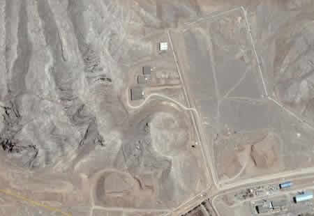
And as of March 23, 2006, courtesy of ISIS and DigitalGlobe:

isfa-isis.jpg

Once the uranium is processed into UF6, it is ready to be enriched at Natanz, 130km to the north. Here, two “cascade halls” have been progressively buried under successive layers of concrete and earth. These facilities are where the thousands of centrifuges are expected to be located that will increase the concentration of the uranium-235 isotope, which is the component needed for both nuclear energy and nuclear bombs. (A concentration of 3.5% is sufficient for nuclear energy. 80% is required for a nuclear bomb.)

Here are the facilities in Google Earth, from a few years ago:

natanz-goog.jpg

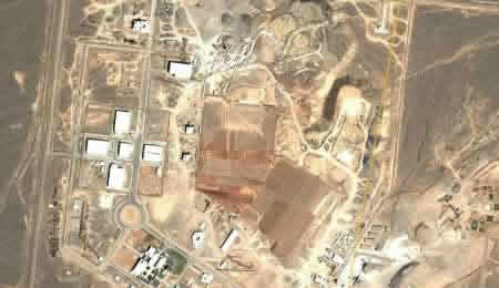
And here they are, on February 25, 2006:

natanz-isis.jpg

ISIS’s PDF report also shows smaller images of these halls being covered up progressively over the past few years.

Both these sites will be military targets if diplomacy fails to steer Iran away from its nuclear weapons program — either for US missiles or, failing that, Israeli planes. The spectre raised by the Seymour Hersh article in last week’s issue of the New Yorker is that the US may be thinking of using tactical nuclear weapons to get to the facilities.

Some honest questions, then: Couldn’t the underground facilities at Isfahan be rendered inoperable by three deftly aimed conventional missiles at each of the tunnels? So what if the stuff inside is intact, if nobody can get to it? And as for the 8 meters of rubble and concrete over the centrifuge halls in Natanz (as reported by ISIS) — it looks like conventional weapons can easily deal with that: The US military’s GBU-28 deep penetration bunker buster bomb is advertised as being able to penetrate such depths. There is therefore no need to progress to depleted uranium bombs or tactical nukes. In any case, centrifuges are very fragile; shake them up too much and you can start over.

So, thank you ISIS and Google Earth for providing the transparency that lets the public ask informed questions that governments now need to answer if they want their version of events to be credible.

[New to Ogle Earth? Here is some more recent content you might like:

What if New York had the world’s tallest building?

Sweden plays hide and seek with maps]

[Update 2006-04-21: This IHT opinion piece by Michael Levy has essentially the same analysis.]

Shorts: 3D virtual art to get recognition

  • 3D art with SketchUp. (Original picture.)

    sketchup2.jpg

  • Perhaps the previous bullet point comes just in time for Sonar, “a festival of advanced music and multimedia art” to be held in Barcelona in June. One of this year’s themes, according to We-make-money-not-art blog, is “Google Earth and Google Maps Hacks”. Some other works of art made for Google Earth blogged on Ogle Earth recently: Surreal Scania and the Angel of the North, the Cheney shooting, and my own dadaist masterpiece, A food processor threatens Boulder. (Many overlays and network links are veritable works of art too.) I expect 3D virtual art will become a new popular genre for expression, now that the means for viewing it have gone mainstream. Kudos to Sonar for seeing this so early.
  • Yet another German Google Earth site: GoogleGeoData, which comes with a German-language Google Earth news feed. Germany has really taken to geobrowsing — Germans were first out the gate back in July last year to integrate Google Earth with Wikipedia and paragliding sites.
  • Genealogy blog Students of Descent writes about work in progress on a script that will convert GEDCOM files to KML. (GEDCOM = GEnealogical Data COMmunication files, a de facto standard for tracking family lineages.)

Free Tibet campaign features Google Earth

A very well-executed web video (1:13) on Google Video (natch) excoriates Google for having Tibet labelled as a part of China in Google Earth. Two points:

metaverse.jpg

  1. Geeks will notice that this is the first instance where Google Earth actually shows up in a virtual 3D environment, and will immediately think of Neal Stephenson’s Snow Crash, where CIC Earth is in fact part of the metaverse. (Apologies to normal people.)
  2. Google isn’t being evil, at least not any more than almost all official toponymical sources, globally. But there are two things it could do to inoculate itself against this and future criticisms:
    1. Outsource responsibility for Google Earth’s naming and border layers to a trusted third party, like National Geographic.
    2. Add a base layer you can turn on that maps disputed territories, names and borders. This is the equivalent of how Wikipedia deals with controversial topics — it turns the dispute into a meta-debate on a separate page — and Google Earth should do the same, perhaps even in collaboration with Wikipedia; it’s not like there are space constraints in a digital universe, and Wikipedia already links to places and regions, so why not to borders and names too?

(Via GoogleGeoData via Google Blogoscoped)

Spring cleaning for Ogle Earth

Extra days off are a good opportunity to plow through that Ogle Earth to-do list. Here is what I have ticked off:

  • I’ve just gone through the past few months’ worth of posts and updated the the resource list in the right-hand column with the new items I blogged during that time. The list of Google Earth websites, blogs, applications and content is growing at breakneck speed. Newest additions are highlighted yellow. If you’re reading this from a feed, come in and take a look.
  • I’ve long appreciated Connotea‘s social bookmarking tool as a fount of GIS content to explore. Unlike more mainstream social bookmarking tools, the items tagged there are of a uniformly high quality, in part because they are constantly updated by people like Declan Butler and Pierre Lindenbaum, who use it as a professional research tool. Declan recently wrote about how he uses Connotea for his articles on virtual globes. Anybody can register and add links.

    I’ve now (provisionally) added the most recent Connotea bookmarks tagged with “GIS” as a feed in the right-hand column. If it doesn’t result in spam, I’ll probably keep it.

I also appreciate your feedback. Website logs tell me where visitors come from but not who they are — casual surfers, GIS pros, technology geeks, early adopters… Who are Ogle Earth’s regular readers?

And I’m wondering what kinds of articles there are too much of or too little of on Ogle Earth, whether you use the resource list in the right-hand column, what’s missing from this blog and what’s too much. Feel free to leave a comment or else email me directly.

Weekend reading

It looks like it is going to be a quiet weekend, newswise. All the more time, then, to follow these links:

  • Geoplace.com carries An Impending Massive 3-D Mashup, first of three in an article series by Fred Limp, who directs the Center for Advanced Spatial Technologies at the University of Arkansas. It’s an outlook for the 3D industry, with special focus on geospatial applications. I learned a lot.
  • Google Earth has been used to spruce up video podcasts before, but here is a new one. it would be even better if the guy could actually dance:-) (Via Digg)
  • James Fee’s Spatially Adjusted notes the updated ETA for the public beta of ESRI ArcGIS Explorer: No longer later this quarter, but “later this year.” His commenters show some apprehension.
  • I’m a sucker for KML placemark files linked to panoramic images, hence the link to a file of Wolfgang Stich’s photographs from central Europe.
  • ZNO blog produces some more Google eArt. This time, it’s an interpretation of Dustin Shuler’s Spindle. Kudos to ZNO for getting the colors right, mostly. And the licence plates are a nice touch:-)

    DShuler1004a.jpgznocars.jpg

  • Press release: RDV Systems Lets Autodesk Users Publish to Google Earth. A free 30-day evaluation is available, though not until and unless they get their website to work. It’s usually a good idea to do that before issuing a press release that links to it.
  • I don’t believe I’ve mentioned Geotags.org blog before. Nor ToBeDetermined, the blog.
  • Google Earth Blog notes that the the latest beta of the pro modeling app for Windows Rhinoceros now exports KML for Google Earth. There’s a free evaluation download. It appears that you need to own a serial number to download the beta. (Although this site is also down currently…)

Short news: Coral bleaching, grassroots Earth

  • Globezoom.info is home to a German Google Earth Community forum.
  • Coral bleaching: The National Oceanic & Atmospheric Administration’s (NOAA) Satellite and Information Service has produced some very professional network links that show, among other things, global ocean water temperatures in near-real time.The datasets help illuminate the phenomenon of coral bleaching, where corals die off due to overly high water temperatures. Divester blog has a great and knowledgable writeup, so no need to duplicate the effort here.
  • Google Earth as a grass-roots collaborative foreign policy tool? Kathryn Cramer proposes some concrete steps that could be taken amid the current talk of escalating the conflict between the US and Iran. The basic idea: Make high-resolution of Iran available to all on Google Earth, so that neither government’s claims are opaque to the scrutiny of concerned individuals. It’s an great idea — imagine if Google Earth had been available with high resolution imagery of Iraq as recently as 2002…