Category Archives: Uncategorized

Reviews you can lose: SketchUp

Mumbai Mirror reviews SketchUp, and concludes:

I quite like the software: It’s free, it’s a tiny download and you can be glorified for your designs online. But it takes time to learn and, as far as ease of use goes, it has a long way to go before catching up to competition.

Wow, the reviewer must be really proficient at AutoCAD and Microstation, then…

Short news: Geoblogger, Vlogmap, Earth Bridge, Global-i

  • Christian Spanring updates Geoblogger.eu, removing content already present in Planet Geospatial. Writes Christian, “Geoblogger.eu should now be a nice add-on to planet geospatial, for people interested in mainly non-english geoblogs.”
  • VlogMap Community notes that Vlogmap.org gets a big fat mention in Wired Magazine: “Google Earth fans have studded the big blue marble with local vlogs. The result: a one-stop global Web-vid spree.” The Vlogmap Google Earth network links show that indeed, the number of vlogs has ballooned over the past 6 months.
  • Earth Bridge is a very fancy-looking real-time GPS tracker for Google Earth.
  • Via Data Mining, Global-i Application. It’s a wireframe 3D globe inside a web browser, but comes with lots of geopolitical data (though you have to pay to get it all). I really wish those controls were available on Google Earth, or that you could construct a network link based on preferences such as these.
  • Following up on a recent post about how Google is aiming to preëmptively “semanticize” new content for the web… Google Blogoscoped points to a call for taxonomy leaders by Google for Google Base, to help set up the right data attributes for content contributed to Google Base.
  • French tech blog Innis went to virtual reality conference Laval Virtual 2006, and brought home a video of the most innovative display technologies, including some that would come in handy for navigating 3D globes. No French required to see it.

Short News: SketchUp Pro forum: Don’t mess with us!

Earth on the mobile phone

wayearth.jpg

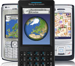
Remember the video of the 3D Google-Earth like application for Java-enabled mobile phone posted a few days ago? Swedish mobile gadget news site mobil confirms it’s of Swedish company Wayfinder‘s mobile app Wayfinder Earth, whose beta is due to be released May 2.

The news site reports that the application will allow you to type in a place name and then zoom in to it, and will also show restaurants, hotels, etc. It also says the free application is part of a strategy by Wayfinder to attract more users, who would then be enticed into buying services directly through the app.

All this puts Wayfinder into something of a competitive position with Google’s recently announced Google Maps Mobile. Google’s product is definitely 2D, as the working online demo shows. Also, it uses the same technique as with Maps, where you zoom in to predefined levels, and then scroll across different map tiles.

Wayfinder Earth is seen using a two-tiered vector-based solution: A Google Earth-like 3D interface for further out, and a 2D interface when zoomed closer in. The video shows smooth zooming at all levels, with the maps as vector data downloaded and rendered on the phone.

3D Warehouse wishing, cont.

Excellent. 3D models, such as this one of the Aqueduct of Fréjus are appearing in 3D Warehouse with links to Wikipedia, and this means that Wikipedia will soon be linking entries to objects, when relevant. A great idea.

What to do, however, when you want to comment on the object itself? For example, the above-mentioned model disappears underground when terrain is turned on, so it requires a fix. But reporting a “bad item” is a rather heavyhanded response, and it’s not easy to get in touch with the author.

3D Warehouse mini wishlist

washmon.jpg3D Warehouse seems to be down this morning (the site returns a server error, and the network link links to models that won’t download) [Update: Back up as of UTC 11:06] so while the kinks are being ironed out, here is an early wishlist for this amazing resource.

  • RSS feeds for new objects. So I can get a list of what’s new in my browser. (Perhaps even using GeoRSS encoding? This would be a perfect use for it.)
  • RSS feeds for search terms. So that I can see all the new items containing “Sweden” in the description, for example, or “library” — similar to how you can get saved searches in Google News as a feed.
  • Have a way for 3D Warehouse objects downloaded via the network link in Google Earth to override the base buildings layer. At the moment, contributed objects “compete” with the base layer, as the screenshot of the Washington Monument shows. It would be nice to have the base buildings layer act as a placeholder until something better is downloaded. This is probably quite a technical challenge, and would require version upgrade of Earth. (Possible 3D content management system for Google Earth blogged previously here: Future Earth.)

collection.jpgA nice touch in the 3D Warehouse network link: If there are too many objects close together, the feed returns an object collection, with its own icon, and it disaggregates when you zoom in.