Category Archives: Uncategorized

Advanced hurricane impact analysis, with Google Earth

preview_pathbuff.jpgBrian Timoney and his group have released another impressive demonstration of Google Earth’s usefulness as an analysis tool — Gulf Impact: The energy impact of Rita and Katrina. It lets you upload a hurricane path in the Gulf of Mexico (or use the supplied path for Katrina or Rita), specify a impact zone of arbitrary size around it, and then have the server calculate the amount of oil and gas production that such a hurricane would affect inside this zone. All this is then rendered onto Google Earth, with plenty of additional static layers for context.

Brian explains it a lot better on his site, and in any case you really need to see this in action. Coming up next: An interview with Brian Timoney.

Annotating the Metaverse Roadmap

Last weekend saw the gathering of virtual-world luminaries at the Metaverse Roadmap summit. ZDNet covers it, as does 3pointD.

Plenty to read there. I just want to highlight something 3pointD’s Mark Wallace writes, so I can riff off it:-)

[…] You might navigate a context-sensitive avatar from one world to another, bringing with you reputation data and other assets, though your virtual form and abilities would change to suit the 3D environment you were entering. And all virtual worlds would be accessed via a near-universal 3D browser (much like Web pages are today).

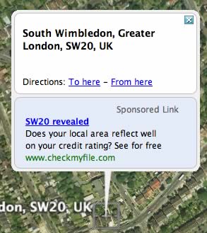
The ability to link the web to virtual worlds has been possible for a while. For example, here is a link to Google Earth for Austin Hall, Cambridge. 3pointD offers a link to Austin Hall [Second Life link] in Second Life.

On a lark, I tried linking from one virtual world to another, by creating a placemark for Austin Hall in Google Earth that links to Austin Hall in Second Life. It works! (At least on my Mac, using an external browser.)

“Linking” in web parlance becomes “teleporting” in avatar-speak, but whatever you call it, you’re mapping from one virtual world to another, binding them closer together, and that’s a good thing, metaverse-wise:-)

What about mapping every point in one world to a unique point in another world? That would make sense if the worlds describe the same place, as do Google Earth and NASA World Wind. It would make less sense, but might still be fun, if the places are different but the geometries are the same: For example, both virtual Mars and virtual Earth are described by an elliptic geometry, so their coordinates can do double duty.

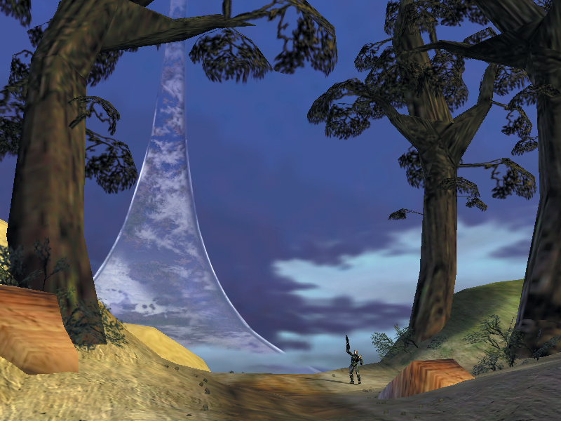
Virtual worlds that do not try to mirror the Earth or other globes do not need to adopt an elliptic geometry. Indeed, Second Life exists in Euclidian (flat) space, as does World of Warcraft. Variations on the theme exist: Arthur C. Clarke’s book Rendezvous with Rama describes a cylindrical world. Halo takes place on a ring world.

hyperbolic_paraboloid_animation.png
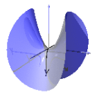
All this leaves plenty of room for metaversal innovation. Where is the virtual world described by hyperbolic geometry? kleinb.jpeg
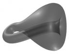
How about building a community on the surface of a Klein bottle, or a Möbius strip? I’d sign up for it, even if just to figure out what such mathematical spaces “feel” like. The future universal 3D browsers mooted by the Metaverse Roadmap would need to be able to render these other geometries, however.

I think this is going to be the main attraction of virtual worlds over the real world: They don’t demand obeisance to the laws of physics, just the laws of mathematics, and even there you can decide the ground rules. I spend most of my time in Second Life and Google Earth flying around, for example, because I can.
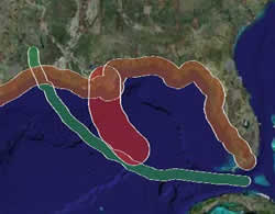
It’s a big metaverse. Somebody has to furnish it.

vilabysu.jpgAwesome. Over on Form Fonts 3D, 97 pieces of IKEA furniture ready to download, which you can then use to furnish your SketchUp dreamhouse (or student hell-hole). They’re yours to use if you pay the $11/month subscription fee.

vilabyik.jpgYou’ve probably guessed where I’m going with this: IKEA should hire these designers to make a SketchUp version of every item in its catalogue, and have it available for download, free, from its online store. That way furnishing your house doesn’t become a guessing game with measuring tape. You simply fire up the SketchUp model (which you’re prepared earlier:-) and move furniture around at will until you like how it looks/fits. Perhaps a SketchUp plugin could keep financial tabs on your IKEA habit, and offer to place the order when you’re done.

But even if you’re not in the market for furniture, and just want something to populate your architectural flights of fancy, free virtual IKEA furniture would lead to plenty of placement ads at no cost to it, and even more mindshare. No Massive required.

Google testing adwords in Earth (again)

adwordg.jpg

The Radioactive Yak has discovered adwords in Google Earth again today, when searching for Wimbledon. Google was last seen testing adwords in Google Earth in mid-January.

I too could get ads for Wimbledon, and Wimbledon South, but not for any other search term I tried in Europe. The service it links to, checkmyfile.com, is relevant in that it offers credit reports by UK post code. (Via Search Engine Journal)

Short news, Spring edition: Urban Tapestries, SketchUp does history in 3D

  • Look, another local Google Earth blog: Google Earth CoolStuF is a Dutch blog focused mainly on local dynamically updated overlays, but European and global ones sneak in there as well.
  • More collaborative geospatial authoring gets retrofitted with KML. Now it’s the turn of Urban Tapestries, a London-based “experimental software platform for knowledge mapping and sharing — public authoring.” The trial run from 2004 is now available as a KMZ file. It’s not unlike geotagged public SMS messages with personal impressions or photos. The nexr version, UT2, will include Google Earth support by default; this could turn into a popular form of microblogging.
  • Finnish Web 2.0 thinker Jyri Engeström visits Tim O’Reilly, and reports that virtual worlds are very much on O’Reilly’s radar.
  • Suddenly, not one, but two how-tos for exporting AutoDesk Civil 3D data to Google Earth.
  • The Sierra Club gets ever more proficient in using Google Earth as a way of supporting its campaigns. Here’s Vancouver under water. (Previously blogged: Sierra Club does ANWR.)
  • Excellent: Historic buildings are being recreated in SketchUp, ready for placement in Google earth. Here’s the lighthouse of Alexandria, one of the ancient wonders of the world, by Hidz. Perhaps 3D Warehouse’s metadata could already include a time attribute, in anticipation of the Google Earth timeline? (Via The Stoa Consortium)
  • Over on Google Earth Community, a great collection of network links by various authors, made available as one download. This is a great resource for developers, but also for those building content. Do try it.

Google Earth, geospatial tree map alternative

You’ve seen tree maps used before: They’re a visualization technique for showing hierarchical data inside a fixed space, like so.

Datasets about influenza virus mutations are hierarchical — there are ancestor- and offspring strains — so these naturally lend themselves to a tree map visualization technique. But such data can also have a geographic component, related to where the strains are reported — and this is what led Andrew at Guiology to perform a remarkable experiment: Using Google Earth as a geospatial alternative to tree maps for visualizing such data.

The results are very pretty indeed:

ai8.jpg

Andrew has a thorough write-up, with much more eye candy. [Update: Andrew will post again when the research is complete. In the meantime, consider the image above to be a teaser.]

Imagine what this could look like when Google Earth gets a timeline. (I’m trying to get my hands on an actual KML file of this unexpected, highly creative use of Google Earth.)

GPS Visualizer: Now for geotagged photos

What you may have known: GPS Visualizer, a Swiss army knife for getting geographic data into Google Earth and Maps, lets you upload data files to produce KML. Just add the relevant column titles to the first line of the document (i.e. “name,desc,latitude,longitude,color,URL”) and GPS VIsualizer automatically knows how to parse rest of the file to output KML (or Maps, JPEG, etc.).

News: Adam Schneider, the author, has now gone one better. Uploaded files can now contain “thumbnail” and “photo” as column headers, with the fields pointing to URLs. The result? Instant georeferenced photo collections in Google Earth, with thumbnails as icons. Click on the marker, and you see the photo in its original size.

Here is an example KMZ file made by Adam from this CSV file.

Adam says he’s working on beefing up the documentation to catch up on these undocumented features, and feedback is appreciated. In the meantime, he adds some details:

I know people are starting to geo-tag their digital photos more and more, so this could definitely be useful; the question is, how to make it easier for people? Do geotagging applications have an “export” function that could take advantage of this?

This stuff works in ordinary Google Maps as well; the thumbnails don’t initially appear on the map, but they’re in the mouseover labels, which is pretty slick.

The only thing to note is that a line can’t begin with a blank field (i.e., a comma or tab) or with a pound sign (#); that’s so that you can “comment out” some lines with “#” if you need to. So, just to be safe, it’s never a bad idea to make the first column “type” and put a “W” (for “waypoint”) on each line. (Obviously, this also comes in handy if you want to include trackpoints in the same file.)

The names don’t even have to be THAT precise. Anything starting with “lat” or “lon” will work for the coordinates; altitude just has to begin with “alt” or “elev”; speed can be “speed”, “velocity” or just “vel”; “color” can be spelled “colour”; and so on. I’ve tried to make it as clever as possible.