- Valery Hronusov is making good use of EditGrid to calculate great circle distances.
- Google Saves, continued: WorldChanging has anecdotal evidence of Google Earth helping locals identify air-drop sites in Surat, India after the flooding there last week. (Thanks, Jonathan)
- Richard Treves — he of the KoKae tutorial screencasts for Google Earth — has built a template for the education-oriented Moodle content management system that produces KML for databases that contain latitude and longitude data types. If you use Moodle, here is the thread you need.
- Interesting item in the comments, worth singling out: “Are there any guide/climber/back country adventure types out there who are increasingly using google earth to scout trails? I need your stories and comments for an article in a national magazine. Please contact Jon kovash.
All posts by Stefan Geens
Visualize Colorado public school test scores
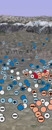 Brian Timoney and Ubiquity Design come out with CSAPscores.org, yet another visually striking geospatial data visualization — of Colorado public school test scores, by district and by subject. The main site is Google Maps-based, but there is also a Google Earth launch page where the data is presented as KML files. I find it easy and intuitive to use, and it should be a real boon to parents. With any luck, these kinds of visualizations will soon be the norm for this kind of data. Or, as Brian puts it:
From where I sit, the twin obsessions of the American middle class family are real estate and education. Zillow seems to have the former covered. But with all of the controversy about failing public schools in the US and the federal No Child Left Behind Act, shouldn’t accessible map-based interfaces be a required part of the conversation?
Short news: 3D London soon? ESRI ArcGIS Explorer soon?
- It looks like we can expect a fully 3D version of London in the coming weeks. I can’t wait.
- GoogleMapsMania points to BuddyMapping, a web app that uses Google Maps to let users build guestbooks for their sites. Comes with a KML version for viewing.
- Beginning Google Maps Applications, the blog of the book, has a nice tutortial out about how to crawl and parse XML and HTML pages to turn them into KML. (Via Google Earth Blog)
- Eagle-eyed Digital Geography spots a download button on the ESRI ArcGIS Explorer home page, and some interesting hints as to what kinds of maps will be available. Alas, no actual downloads are in sight, but surely this means it can’t be much longer to wait?
- James Fee predicts ESRI ArcGIS Explorer won’t be a “Google Earth killer” in the sense some people imagine it. I certainly don’t hope this is the sound of expectations being lowered. I want as many geobrowsers to play with as possible.
- Over on Lasting News, Laurent is all over the latest periodic outburst from an Indian official regarding the threat of Google Earth to national security, as reported by India’s Express News Service on August 12. This time, it’s Air Chief Marshal S. P. Tyagi’s turn. Laurent does all the explaining in his post as to why the claim is absurd.
- Looks like Google Earth was inaccessible again in Bahrain yesterday.
PS: I just noticed that a couple of comments were caught in an over-eager spam filter. It’s now been turned off. Apologies.
DIY in-car navigation with Google Earth
On my way back from San Francisco to London I again had plenty of time to ponder how Google Earth would do a better job at in-flight tracking than the same standard visualization we’ve been familiar with for what must be a decade now. The current stuff look seriously aged.
Another place where Google Earth is an obvious fit is for in-car navigation and tracking. Volkswagen has already shown us a compelling working prototype, but who knows when that will make it to market.
No need to wait. Over in MP3Car.com’s forums, Ryan McCormick has created a Google Earth skin for a touchscreen interface or tablet PC that lets you use Google Earth as an in-car navigator today.

The installation process doesn’t look idiot-proof (I haven’t tried it myself) and it works best with version 3 rather than with 4 beta. But for everyone who is adventurous (and has a touchscreen or tablet PC and a 3G modem and a GPS device and perhaps even a car) this looks like a hack well worth exploring.
How is it done? Ryan used AutoIt for the scripting part, his own SKINBedder for the buttons that frame Google Earth, and GooPS for the GPS tracking. There is a whole subculture for adapting PC applications for car computers — more here about that niche.
Science Foo Camp talk examples
I gave a presentation this morning at Science Foo Camp entitled “The rise of the geobrowser – cool uses in science”. A good broadbased discussion ensued, so much so that I didn’t quite make it through all the examples I intended to show off. I did promise to list them here, however, so here are some of the best examples of:
A sensor web: Atlantic buoys
A citizen scientist sensor web: Lightning maps
Science outreach: Gombe chimp blog (new functionality soon)
History of science: Shackleton’s expedition
Science news: Carteret Atoll
Geospatial wiki: Geonames
Georeferenced database: Global volcanism
Server-side analytics: Gulf Impact
Way out-there visualizations and hacks in the service of science:
Darling-Murray river stream flow data
I’ll be flying on Monday, so this blog will continue to see neglect until Tuesday…
Short news: Left Coast edition
It looked dubious at times, but I did manage to travel yesterday from London to the US (of all days!) and made it to San Francisco today, where I’ll be at the bottom of the food chain at Science Foo Camp. Some of the discussions will surely be about geospatial data visualization, and the role geobrowsers are playing in democratizing access to such data. If anything relevant to Ogle Earth’s brief happens, I’ll blog it here, of course. In the meantime:
- iPhototoGoogleEarth is up to version 0.9 — it now works with Intel Macs.
- KML Regionator “is a set of sample Python classes, algorithms and scripts that exemplify some methods for creating Region-based KML” (from the readme.) Very handy &dmash; regions are very powerful, but quite a drag to code manually (I’ve had a look). A region-based KML generator is therefore a must if you want to create something non-trivial with it.
- Make Star Trek models with SketchUp, get them displayed at a Star Trek convention. What, no prizes? Deadline is this coming Sunday. (Via Google Earth Blog)
- It seems that Google Earth is no longer blocked in Bahrain, though nobody is terrible sure about what is going on.
- Orangetea is looking for beta testers for Fly With Me, a new service they’re developing where you can lead remote users on a collective tour of Google Earth places you’ve selected.
Very short news: ASP.net & KML; travel advisory
Earthware Blog came across “issues” using ASP.net to write KML and KMZ to Internet Explorer, but they’ve solved the problems… and blog the solution.
As for me, I’ll be travelling for the next week, so this blog’s coverage is likely to be quite intermittent.