New & updated layers: Tracks4Africa, ARKive, WaterAid

It’s raining new and updated Google Earth default layers!

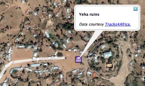
Tracks4Africa: I happen to live in Africa, so I’ve been especially grateful for the existence of the Tracks4Africa layer in Google Earth, a collaborative effort by GPS-wielding travellers to map a continent sorely in need of good maps. The Tracks4Africa layer is far more accurate than Google’s own default road layer, and also includes such essential information as petrol stations and police checkpoints (all of which has come in useful in preparing routes in both Egypt and Ethiopia).

Sometime in the last few weeks, and I suspect as recently as in the last day or so, the layer has gotten a whole lot more sophisticated: It’s turned into a folder containing categorized roads, but also further folders for hiking trails, points of interest, activity destinations and &mdash this is unexpected — “community photos”:

tracksphoto.jpg

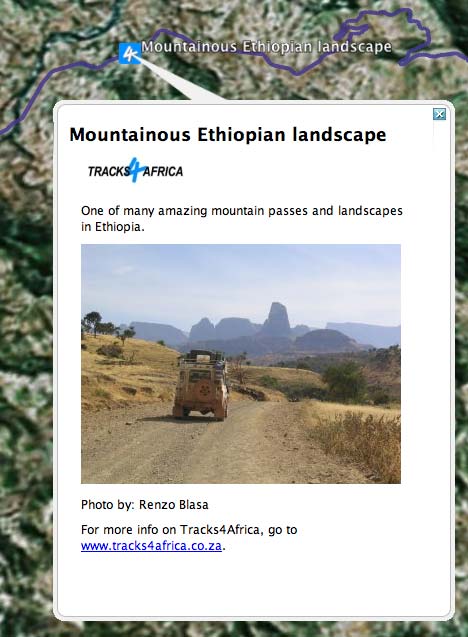
All of this means that some very out-of-the way destinations that I previously had some trouble finding myself on Google Earth are now clearly marked, as is the way there:

yeharuin.jpg

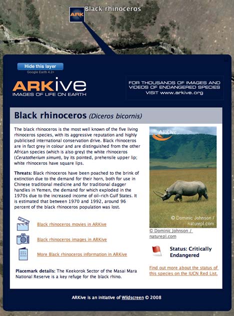
ARKive: ARKive (get it?:-) is “a unique collection of thousands of videos, images and fact-files illustrating the world’s species” that lists Sir David Attenborough as a fan. They’ve now got a layer depicting georeferenced endangered species on Google Earth, like so:

arkive.jpg

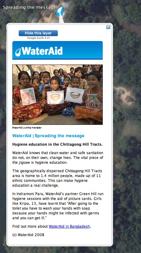
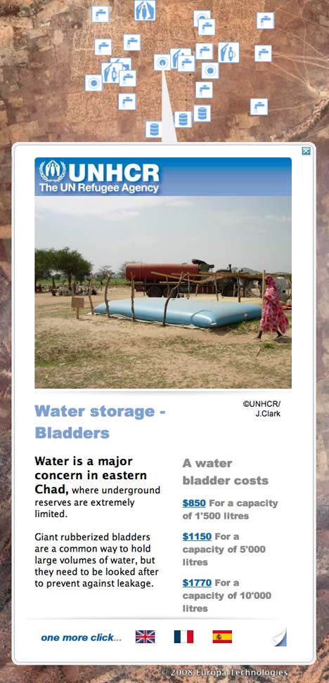
WaterAid: is a charity whose mission is to “overcome poverty by enabling the world’s poorest people to gain access to safe water, sanitation and hygiene education.” A whole bunch of placemarks in South Asia and Africa explains WaterAid’s work. For a relatively unknown charity working on one of the biggest upcoming issues in development, there is no better bang for the buck in getting your work known than getting onto Google Earth, like this:

wateraid.jpg

Links: Google’s naming doctrine, Géoportail to get API, Google Sky lawsuit update

  • Google’s “Primary, Common, Local” doctrine: Does Google’s Director of Global Public Policy Andrew McLaughlin have the best job ever? He gets to write long posts entitled How Google determines the names for bodies of water in Google Earth for their official Public Policy Blog. It’s a fascinating read.

    McLaughlin never mentions one particular body of water, lying between Iran and Saudi Arabia and which contains a lot of oil, but I can’t help thinking that his long explanation is an implicit defense of why Google Earth labels it both Persian Gulf and Arabian Gulf; this in the wake of an online petition by sympathizers of the Iranian stance that Google should remove the latter name and keep only the former. When I last visited this issue, on February 24, the campaign was shy of 13,000 signatures. Currently, it has 94,188 signatures.

  • Géoportail to get API, KML support: Renalid reports (in French) that Géoportail, the web-based 2D/3D mappping application by France’s National Geographic Institute, will get two AJAX APIs on April 21: API Web2D and API Web2D Pro. The basic one is free, the Pro one will incorporate GIS functionality, such as support for WMS. KML support is also mooted, though it is not clear if this requires the Pro API. (Please please make it accessible to the masses). A 3D API is due in the summer, writes Renalid. Here’s hoping for more generous tile quotas than the UK Ordnance Survey’s OpenSpace.
  • Google Sky lawsuit update: If you want a good example of the wasted man-hours caused by frivolous lawsuits, look no further than this page, which charts the progress of the lawsuit against Google by Jonathan Cobb for the alleged misappropriation of the Google Sky concept, an allegation already previously debunked here. The lawsuit was filed Feb 13. On March 28, Google replied, denying everything substantial.
  • Webby nominees: Georeferenced panorama photo repository 360 Cities is shortlisted for a Webby.
  • Google App Engine announced: This is big. Soon, Google will be offering to scalably host your dynamic KML network links and the apps you build to generate them. One less reason to keep your own server. Cloud, meet KML KML, Cloud.
  • Google Earth Pro does reverse geocoding: Somehow, I’ve missed this until now.
  • Google Streetview privacy lawsuit pics: The Smoking Gun has them.
  • AutoCAD 2009 to Google Earth: Updated Google Earth Extension for AutoCAD Now Available
  • KML in the North: April 23, Fairbanks, Alaska: “The Geophysical Institute and Arctic Region Supercomputing Center are hosting a one day symposium dedicated to demonstrating and teaching about the use of Keyhole Markup Language (KML) by researchers at the University of Alaska Fairbanks.” Organizer John E. Bailey adds: “Aiming to make the presentations available as YouTube vids after the event.” I strongly suspect it will be free to attend.

KML_Poster.jpg

UNCHR releases KML refugee layer

The rush of new content for Google Earth hasn’t let up yet. The United Nations refugee agency UNHCR is also releasing a new layer today in collaboration with Google Outreach.

The layer is not to be found among the default layers, but instead from a new launch page on the UNHCR’s website. Here’s the direct KML link, here’s the press release, and here’s a story about it in the UK’s Guardian.

unhcrchad.jpg

Two things in particular stand out about this layer:

First, it successfully harnesses the high resolution imagery on Google Earth to pinpoint exactly the location of specific components of a refugee camp — in the above case, a camp in Chad. (This is something that the New York Times layer misses out on, as blogged yesterday.)

Second, the popups segue from the specificity of a location into a direct appeal for aid. The idea is that if you can see a specific instance of a need on the ground, you are more likely to contribute. It will be interesting to see if that is the case.

(Just one piece of constructive criticism, however: For some other placemarks, such as those around Damascus, specific local places are pinpointed while the placemark content actually refers to locations far away (New Zealand in one case). I think it is better not to georeference information than to georeference it inaccurately, as then users start to lose confidence in the accuracy of all placemarks. I think that using placemarks as “symbolic” locations markers is a bad idea — you don’t add information, you merely create confusion between those and actual place markers. And it defeats the purpose of using a virtual globe.)

unchrnz.jpg

As the UNHCR’s KML is downloadable (rather than a default layer), you can use it with other applications that support KML. In this particular case, however, only Google Earth is likely to have the high resolution imagery of remote locations that allows this layer to come into its own.

New 3D mouse: SpaceNavigator for Notebooks

I love my 3DConnexion SpaceNavigator; so much so that I will sometimes lug this beautifully designed solid metal contraption across oceans in my carry-on luggage. Hilarity often ensues as X-ray security personnel puzzle over something that looks suspiciously like a detonator, and is built like one to boot. It’s worth the hassle. There is simply no better way to navigate Google Earth.

3DConnexion is today releasing a lighter, smaller version of the SpaceNavigator, fittingly called the SpaceNavigator for Notebooks. It’s half the weight of the original, 1cm narrower, comes with a travel case and costs USD $129 (vs $59 for a personal edition of the original.)

footprint.jpg

Wags may wonder why something half the weight costs twice as much, but I think that’s because miniaturization is not cheap, and because this device is aimed at road warriors — there is no personal edition of the SpaceNavigator for Notebooks.

I have not used a SpaceNavigator for Notebooks, so don’t know if it can replicate the solid feel and weight that makes the original such a pleasure to use. If you’ve used one, comment! (Since some will wonder, this is not a paid post, and there is no advertising relationship with 3DConnexion:-)

[Update 11:14 UTC: PCMag has a full review of the device.]

New layer: Every Human has Rights

The “Every Human Has Rights” campaign aims to raise public awareness of the Universal Declaration of Human Rights, adopted 60 years ago this year by the United Nations. Until now, just countries have been signatories. The idea is to get people to read it and sign it too, so that everyone can know their fundamental human rights.

The campaign now has a default layer up on Google Earth. At the top of each placemark you’ll find an outtake from the declaration, and what it means. Below it, bios of some of the many people who have stood up for human rights, often amid great adversity:

ehhr.jpg

Human rights are something that I feel strongly about, so I’m very happy to have been involved in the creation of this layer. (If you hate the design of the placemark popups, you can blame me:-) The layer itself was constructed using an early version of the Google Outreach Spreadsheet Mapper, with help from Google developers.

Content was collected from a range of NGOs supporting the campaign, which is being spearheaded by The Elders and by Realizing Rights.

Links: GE intelligence, traditional place names

  • Google Earth intelligence blog: Via Ed Parsons, a Google Earth blog focused on military intelligence analysis that I had, unforgivably, not been aware of previously: IMINT & Analysis. It is incredibly thorough. (My only wish — that placemarks be available as KML rather than lists of coordinates.)
  • Traditional placename labels: The Native American Coeur d’Alene tribe has been adding traditional place name labels and audio pronunciations to the map. The results are available as KML. The US Federal Geographic Data Committee is supporting the project with grants. (Via Metafilter)
  • Orphan finds home village using Google Earth: Sob-story in reverse, in the Times of India. In case you’re wondering where Kiraoli is — Geonames.org has the answer. Check out the Taj Mahal 25km to the east.
  • Neogeoweb startup roundup: JotYou — send an sms to someobody, who only receives it if they are in a certain geographic region. Sounds like great game fodder, and good for at least one plot twist in the next Jason Bourne thriller. SpotJots — blogging where location takes precedence (and which would benefit from KML output.) (Both via Renalid)

New York Times mapped: A quick look

The New York Times gets its own layer in Google Earth. The content is top-notch and updated every 15 minutes, but the georeferencing creates the same problems that other attempts have faced: Users of Google Earth are in the habit of assuming that placemarks mark the spot precisely, to the limit of the resolution — otherwise, Google Earth is overkill. Instead, NYT content is categorized by neighborhood, city, state, country or even region, and as a result you get placemarks that mark the middle of nowhere:

sudanorph.jpg

One thing that is new and clever is how the NYT has dealt with stories that belong to multiple categories:

nytcategories.jpg

Still, not until articles are location-tagged manually by the reporter using Google Earth will we get something that feels right every time. In the Sudan story above, we should be able to peer at the roof of the orphanage. In other cases, it might make sense to add migration routes, disputed borders, warzone front lines, multiple placemarks, georeferenced photos, map overlays and/or no-go zones, and have all these linked to from the artlcle — and vice versa.