Spherical displays – a reader question

A friend has been asked to make a purchasing recommendation for a large British scientific organization regarding spherical displays — spheres onto which you project video to display moving images of round bodies like Earth or Mars.

He knows of two, but was wondering if there are more on the market worth investigating.

The first is the PufferSphere by Pufferfish, a British company whose displays are also used at concerts and for art projects, but which seems to have a magical effect on children when displaying the Earth, as evinced by a video from this year’s Ocean & Earth Day at the UK National Oceanography Centre:


Pufferfish @ the National Oceanography Centre, UK. from Pufferfish on Vimeo.

Another is Global Imagination’s Magic Planet, which has a variety of sizes of globes, and can include a range of premade globe software, for example a version of NASA World Wind. It can be run from a PC. You can download a video from this page. (Not having embedded video in 2008 is a bit negligent, no?:-) And so is the 2004 copyright.)

I also found the OmniGlobe by ARC Science Simulations. It also offers a large globe, and comes with pre-installed software that facilitates the showing of planets and adding your own content. See videos of their globe here:

So the question to readers is: Are there other commercial manufacturers of such products you know of? Have you had any experiences with any of these? None of these three manufacturers are willing to quote prices for their devices up front, but my guess is that a big determinant involves the kind of content you want to display — if it needs to be custom-created, it will cost a lot more.

Links: Concharto, Bambuser gets a maps mashup, GPS iPhone?

Back in Cairo after a brief layover in Rome that was definitely Not a Roman Holiday. Here’s what I’ve been reading this past week:

    Concharto: The previously lauded Time Space Map changes its name to Concharto, and has been nominated for the 2008 Prix Ars Electronica in the digital communities category (which, er Wikipedia won in 2004:-).

  • Map tiles as a KML overlay: It’s been done before back in 2005, but for whatever reason the service never survived: Google Maps tiles as a KML network link overlay in Google Earth, courtesy of Cristian Streng over at Mobile GMaps. But this time round, not just that tile is available — pretty much any map that is served over the web via tiles is supported: content from Windows Live Maps, Yahoo Maps, Ask.com Maps and OpenStreetMap.
  • Live video maps mashup: Swedish live video startup Bambuser gets a live Google Maps mashup feature. The georeferencing is less high-tech than Seero‘s, but Bambuser has the advantage that you can send video live from your mobile phone (which Seero can’t yet, and like Qik, which however lacks the mapping feature). Just missing the KML network link now!
  • Second Life on the mobile phone: Second Life for the mobile phone is almost upon us! Vollee is the company behind that tour the force. But this also means a mobile version of Google Earth can no longer be considered a physical impossibility. Imagine adding iPhone-like touch-screen controls to that demo…
  • Cool new KML editing tip: Richard Treves shows you how to consolidate style tags in KML created by Google Earth.
  • Persian petition: Signatures for the petition Immediate and unconditional deletion of “Arabian Gulf” from Google Earth reach 598,615! Most signatories don’t seem aware that both “Arabian Gulf” and “Persian Gulf” are marked in Google Earth, with an explanatory note, but the petition text doesn’t feel the need to disabuse readers of that assumption.
  • GPS iPhone?: So the 3G iPhone may include proper GPS positioning after all. That would make it far more useful for proper mapping applications than what the current technology provides (triangulation via cell phone towers). Geotagging of photos and geotracking would all be accurate to within a few meters. (Nokia N95 update — successive firmware updates to my N95 mean that a true GPS fix is now had within seconds anywhere in Europe and Egypt that I’ve tried… with a little assistance of a Nokia server that does the labor-ntensive raw GPS signal decoding). If the iPhone gets the same level of functionality as my Nokia N95, it will run rings around the rest regarding design and build quality. My N95 may be feature laden, but the build is is feeling rickety and the GUI is slooow.
  • Google Sky horizon: a horizon for Google Sky — for any location on Earth, as a network link updated every 10 minutes.
  • Sense of place: Ed Parsons looks at the latest version of Google Earth from the perspective of how it generates a sense of place.
  • HoudahGeo updated: Mac photo georeferencing tool HoudahGeo (‚Ǩ25) is updated to 1.4.8, with “vastly improved Google Earth geocoding. Google Earth geocoding now provides readings of altitude in addition to latitude and longitude. It now also works when the Google Earth view is tilted.”
  • JetPhoto goes geosavvy: JetPhoto Studio 3 is a major new release of a photo organizing and web publishing tool for both Mac and PC. It’s an interesting hybrid — there is a free basic standalone application, but also a PHP-based server component (not free). The standalone viewer reads GPS track data and generates Google Maps and KML. Worth checking out.
  • KML for maps test: Fortius One’s blog Off the Map compares KML support by Virtual Earth and Google MyMaps. Elsewhere FortiusOne’s Sean Gorman updates us on their progress building a robust system for sharing and publishing metadata-savvy geospatial content.
  • ArcGIS Explorer swipte tool: ESRI celebrated Earth Day showing off some features that other virtual globes can’t compete with — for example the swipe tool.
  • Google Earth for Anthropology: I so hate giving money to Elsevier for scientific research that should be freely available to all, so does anyone have a backdoor link to this scientific paper: Google Earth, GIS, and the Great Divide: A new and simple method for sharing paleontological data? (Via ubikcan)
  • Shocking: NASA World Wind developers and long-time Google-Earth critics “Bull” and Chad actually kinda like Google Earth 4.3 a little — lauding those additions I was the most lukewarm about.
  • Late in reporting, but for the record: Brian Flood’s GETools is an API of sorts for Google Earth for PC. China satellite debris shown in Google Earth.

Sifting information from propaganda re North Korea, Syria

The UK Times of London has a breathless article about how North Korea is building runways under mountains, which it says was revealed by a defector, confirmed on Google Earth, and reported in the South Korean Press last week. Besides not linking to the the location in Google Maps (that’s so, like, 2004), the article has two main problems. One is that knowledge of such runways has existed since at least 2005 and was noted by Google Earth Community members then (note the date of the posting. Here it is, BTW:


View Larger Map

The other is that if you go looking for the original South Korean article, it mentions the original source of the story to be… a Voice of America report last week, while the defector in question defected in 2006. All of which brings the timing of this news item into question.

The article goes on to debate whether the release by the CIA last week of purported evidence about Syria’s nuclear ambitions (which would have used North Korean technology) is meant to harm chances of a peace deal with North Korea (ostensibly at the behest of Dick Cheney’s “people”) or else is meant to improve chances of such a deal by in effect declaring on behalf of Kim Jong Il something he could never bring himself to do, allowing him to save face. I’m not sure. The Times has a botchy record on accuracy regarding the Syria raid and surrounding stories.

And in the interests of equal time, here is an interesting post on a Middle East blog I follow, arguing that the allegations raised by the CIA presentation don’t make sense…

{Update 19:54 UTC: Here is another tunnel airport, mentioned on Google Earth Community in June 2006.]

Syria reactor: CIA makes its case

Check out the presentation the CIA released today laying out their claims that the Syrian reactor destroyed by an Israeli air strike on September 6, 2007 was in fact built with support from North Korea and was intended for the production of weapons-grade nuclear material. Below is the embedded full version of the footage, courtesy of the BBC. Note the use of a 3D display program that looks very similar to Google Earth, down to the textured 3D buildings:

Please turn on JavaScript. Media requires JavaScript to play.

The CIA certainly pulled out all the multimedia stops to convince in this presentation. It is certainly a lot more explicit than the presentation by Colin Powell to the UN before the start of the Iraq War. I’m half hoping that they’ll also release the 3D model of the reactor from the presentation as a downloadable Collada KML file — just because that would be a really cool and innovative way to press their case.

What about the credibility of this presentation? Obviously, Syria and North Korea call it a fabrication, and given the damaged credibility of the CIA from their shenanigans in the runup to the Gulf War, those denials will convince many. But the BBC’s commentators appear convinced by the evidence.

This topic was previously blogged on Ogle Earth here, here, here and here. Download a KML overlay of before-and-after imagery here. The location is now also viewable in high resolution in Google Maps/Earth, as of the last update. You still get to see the reactor before it was destroyed, from a Digital Globe image taken on August 18, 2007:


View Larger Map

Healthy Planet: Neogeo conservation charity

Mark Mulligan, Reader in Physical Geography ay King’s College London and prolific KML content creator, is at it again. On the occasion of Earth Day, King’s is launching HealthyPlanet.org, which lets “individuals and companies sponsor areas of protected parks throughout the world, choosing from more than 70,000 different parks or heritage sites in danger.”

The site won’t be fully functional until the end of week, but Earth Day won’t wait:-). By the end of the week, however, you’ll be able to use Google Earth/Maps to find and “claim” plots of protected parklands around the world by donating to Healthy Planet, a new charity set up in association with the United Nations Environment Programme World Conservation Monitoring Centre (UNEP-WCMC). Proceeds go to conservation projects.

Until then, you can read the press release; if you visit the site today you will find it in preview mode — no adopting of park lands yet.

Links (We’ll always have Paris edition): Google working on supercharged Street View for Europe

Blogging can take a long time when you’re on a Parisian terrace café distracted by the locals on a springtime weekend. As they say, Ceçi n’est pas un geoblogue:

whereyougonnabe: A review

Earlier this week, Peter Batty released whereyougonnabe (beta), a Facebook application that lets you expose your planned whereabouts to friends, and which lets you follow friends, so you’ll never have a near miss again.

In terms of functionality, it competes most closely with Dopplr, a standalone application with a Facebook module that has the same objective.

I already use Dopplr on Facebook, so it was easy to make a comparison. The upshot: Dopplr is simpler to use, while whereyougonnabe is more full-featured. Which you end up using will depend on your needs (and those of your friends).

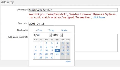
In Dopplr, it takes no time at all to add a new “trip”. Just type a city, which gets recognized on the fly, click on start- and end dates, and you’re set. It is simplicity itself.

dopplrinput.jpg

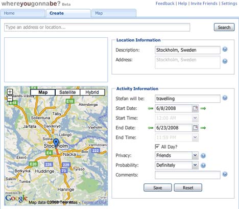
whereyougonnabe takes longer, but you have more options: Instead of just cities you can define addresses were you’ll be, instead of just dates you can define times, and you can specify the probability of the trip taking place. But you are forced to say what you will be doing there (you have no choice), so I wish it would have “travelling” as a default rather than throw a spanner in the submission process if I leave the field empty.

wygbinout.jpg

Dopplr and whereyougonnabe have different strategies when it comes to how you expose your future whereabouts. whereyougonnabe is a Facebook application, so your possible audience is your Facebook friends, all Facebook users, or just you (where you are told of serendipities but others are not). With Dopplr, you choose which other individual Dopplr users can see your trips — and if you install the Facebook module, then so can all your friends.

Where whereyougonnabe truly shines is what it does with the information. Dopplr uses the information of its users to generate a mini newsfeed of who is where — it doesn’t really leverage this information in geospatially interesting ways. whereyougonnabe, on the other hand, is literally all over the map: You can get a view on Google Maps with icons for where your friends will be, and the pièce the resistance is a timeline-enabled KML network link that draws your route and those of your friends, and keeps it updated.

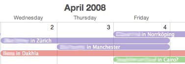
whereyougonnabe’s visual representations work really well for me. To be honest, so does Dopplr’s simple newsfeed, as I am generally able to figure out myself that if somebody is in Ottawa and I am in Paris, that we’re unlikely to meet up. Dopplr’s RSS and iCal feed output is also very handy and fits into my exisiting schemes of keeping tabs on friends (Dopplr’s feed in purple below):

dopplrical.jpg

Where I find whereyougonnabe gets a bit heavy is when it squeezes the geosocial graph for every last bit of info and for every friend: It’s too much effort to read for every user, for example, that:

[xxxxx] will be working at Health Canada, 70 Colombine Drwy, Ottawa, ON, Canada from 7:45 AM to 4:00 PM on Tue. You will be 3516 miles away, meeting at Centre Culturel SuÔøΩdois, Rue Payenne, 75003 3ÔøΩme Arrondissement, Paris, France from Sat to Wed

I’d rather be alerted by proximity alerts than by a wall of text in which the meeting possibilities are hidden. The visual representations on maps and as KML cut through the clutter, but here too it would be cool to highlight close encounters via some kind of color code. At the moment, the home screen has a lot of clutter, which works against usability — Dopplr, on the other hand, subscribes to the “less is more” philosophy, which works well for me.

homewygb.jpg

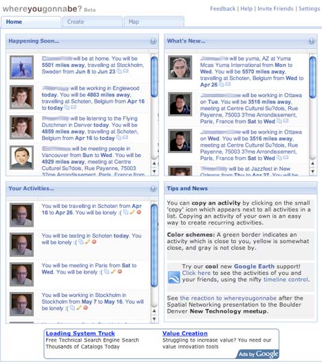
whereyougonnabe’s home page.

But Dopplr has recently also cashed in on an advertising agreement with an outfit called Mr & Mrs. Smith, and of late my every interaction with Dopplr includes some kind of exposure to luxury boutique hotels of the kind that I would never contemplate staying at at my travel destination. It’s an intrusive case of misdirected advertising, and as such comprises a sudden and rather strong pollutant of the experience. whereyougonnabe’s Google ads are far less intrusive, and very sustainable (at least to me).

Some more small stuff: I use kilometers as a measure of distance, not miles, and would like a setting to change that. In any case, precise as-the-bird-flies distances are not very meaningful, I feel. (And a beta bug report: accented characters need fixing:-)

Dopplr doesn’t lock itself into Facebook, but is independent of it, which is a good thing. I’m only using Facebook until something better comes along, and because I’ve been developing some mini apps for my employer, the Swedish Institute (Swedish Word of the Day, anyone?) to better understand the platform. Going forward, we at SI are commissioning a web application that is separate from Facebook, but which outputs via modules to all sorts of current and future formats and platforms, including Facebook, Flash widgets, RSS, email, iPhone… If a new platform reaches critical mass, we’ll have a new module built. I think this is going to be the ubiquitous development model for the next few years. Fortunately Batty knows this:

Our application currently runs on the Facebook Platform. The big advantage of this is that you don’t need to re-enter your network of friends, you can just leverage the existing social graph that you have in Facebook. In future we will support other social and business networking systems – LinkedIn is an obvious target for the business traveler, and of course OpenSocial is on our list too.

I think that in the long run it makes sense to be platform agnostic on this.

In sum, I very much like whereyougonnabe, though I suspect its biggest enemy is going to be my laziness, and that of my friends. If it can simplify the interface, shorten the input process and perhaps offer an XML output option, then the superior map visualization features will make it a winner.