Proof of concept: Microsoft’s WPF/E + Maps

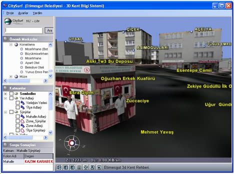
Remember WPF/E, that new Microsoft web interaction and display technology that surfaced as a preview a few days ago? It is supposed run on both Mac and Windows (XP and Vista), and in IE, Firefox and Safari — the clearest indication yet that Microsoft understands future successes on the web will require platform neutrality.

I wondered then if WFP/E might not be a useful mapping tool in combination with Virtual Earth 3D. As for the 3D part, the jury is still out (as it requires Windows-only software), but when it comes to the 2D component of Virtual Earth, Mike Taulty’s already got a proof of concept up on his blog:

What he’s done is add a new layer over the Map using WFP/E to capture mouse movements, translating these into an different navigation mode. Mike also superimposes a new graphic. The upshot: it would be very easy to make some very nifty custom user interfaces for maps using WFP/E.

To try it out yourself, go to Microsoft’s WPF/E download page and download the installer, either for PC or for Mac (it’s a “technology preview”). Run it, restart your browser, and then try out Mike’s demo, here.

I’ve found that it only really works in IE for PC at the moment, but on Safari for Mac it definitely looks like it wants to work. So it’s early days yet, but this is promising. Plus, from poking around on the WPF/E website, I see no reason why this can’t be used in conjunction with Google Maps’ Javascript controls.

Google Earth 4.0.26xx Beta out

A new version of Google Earth 4 beta is out: 4.0.2693 for PC, 4.0.2694 for Mac. Go get it.

Of note are numerous bugfixes, performance tweaks, and improved options, but the one main feature addition that will make life easier for those of us who want to use Google Earth for presentations is that tours can now be made to display balloons. (Google announcement)

Complete change log below the fold. (Thanks Frank!)

Continue reading Google Earth 4.0.26xx Beta out

SimCity, Google Earth, New York City & Elliot Hanson

The fates of Google Earth and SimCity have been intertwined before. Back in August, we had news of gamers using Google Earth as a visual reference for the accurate recreation of real cities in SimCity 4. We also heard of a method to convert SketchUp models to SimCity models.

Region Map.jpgFast forward a few months, to an interview in BitsBytesPixelsSprites with Elliot Hanson, who is recreating the entirety of New York City pixel by dimetric pixel in SimCity. The interview has some stunning images, but there’s even more on Elliot’s own blog, The New York City Journals. I especially like how some projects are seasonal or event-driven, animated by scripts built into the objects — for example, there is a Thanksgiving day parade, and a recreation of 9/11.

Macysthanks.jpg
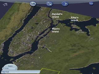
Not surprisingly, Elliot is also playing with Google Earth, collecting models from 3DWarehouse of New York Buildings. All this leads to an obvious question: Might it not be possible to export SimCity content as a SketchUp model, ready for positioning in Google Earth? Pixel art in Google Earth would be quite a trip, and a layer in Google Earth with Elliot’s work in it would definitely give it wider exposure. We know it’s possible to export 3D content from Second Life and World of WarCraft, as shown by Eyebeam’s OpenGL Extractor, so why not with SimCity?

And thinking further ahead, if/when Google Mars comes out, the opportunities for populating that planet with SketchUp models should make for some excellent collaborative creativity. Anybody up for a chalet with view overhanging the edge of Valles Marineris? It would make for an interesting mirror world/virtual world hybrid, especially as the Mars imagery won’t come with pre-existing infrastructure on it. Hmm, Martian Chronicles, the MMORPG. Isn’t it great we live at a time when such ideas aren’t outlandish?

Oops: NASA & Google launch event delayed

Spaceref.com now reports:

Editor’s update: While this [collaboration] announcement will still happen, NASA ARC PAO now says it has been delayed until a date that has been “mutually agreed upon by NASA and Google.”

As for what this announcement will be about, Romyn in the comments makes a good case for it being iEarth, as written up by New Scientist:

Called iEarth, the NASA software scours EOS databanks for information and converts it into a file that can be viewed via Google Earth. Choosing a spot on the planet’s surface will prompt iEarth to display ground-based measurements for that location, as well as data relating to the atmosphere and space above it.

It’s due in April, says NASA. Maybe Google didn’t want to pre-announce, or else iEarth is being rebranded YouEarth:-) (Via tobedetermined!)

[Update 20:56 UTC: Keith Cowing’s “Editor’s update” on NASA Watch is even better:

While this announcement will still happen, NASA ARC PAO now says it has been delayed until a date that has been “mutually agreed upon by NASA and Google.”. ARC PAO”s Laura Lewis also chided me for posting an internal memo. I guess it did not occur to her that sending an email to several thousand people about a “kick off event” is tantamount to announcing it publicly since the memos get forwarded almost instantly. Indeed, that’s the point of such widely distributed emails in the first place – messages that carry no admonition about further dissemination.

Moral of the story: Don’t ever, ever tell bloggers anything that is not for blogging without telling them it is not for blogging:-)]

What are Google and NASA up to now?

This sounds exciting: A media advisory for Friday Dec 15 has Google and NASA Ames Research Center (ARC) announcing a new kind of collaboration. SpaceRef.com has some hints as to what this entails (but doesn’t get specific):

Among other things, the collaboration will focus on an agency-wide project whereby NASA imagery and data will be translated into formats that will facilitate its wider distribution outside the agency. […] Among the details of this new cooperative project, Google will be contributing funding to support NASA employees – and not just at ARC – but at other NASA centers as well.

I have no idea what this announcement will be about, but I can make wild guesses. Do note that Google Earth is due an update — the last couple of updates have been six weeks apart, and the last one was six weeks ago. Also, NASA Ames specializes not just in aerial imagery but also in Mars and Lunar imagery. And NASA has now begun offering aerial imagery as KML. So either we get a much deeper integration of NASA images in Google Earth, or we get a virtual globe for Mars (which disappeared when Google bought Keyhole) or the moon. Or I’m just overexcited. (Via Search Engine Land)

CitySurf: 3D city viewer from Turkey

Adil Yoltay writes in about CitySurf, a free 3D viewer from Turkey:

We are 3 developers have started 2 years ago CitySurf Project and it will be finished nearly. CitySurf free OpenGL-based viewer, which connects to servers for streaming of content, elevation, imagery, road outlines, 3D buildings, points of interest, etc. (like google Earth and Microsoft Virtual Earth concepts but faster then others).

A Youtube video of the app in action is quite impressive, showing plenty of textured 3D models:

They presented at Cebit 2006 Istanbul, and made it to Turkish CNN — video snippet here.

You can download the application, and I gave it a quick run. Everything is in Turkish, but you can easily guess which buttons do what. The interface looks a lot like Google Earth or ArcGIS Explorer, with layers for points of interest located in Turkish cities. Labels and roads are vector-based (nice), navigation is snappy, and some of the 3D buildings have very high resolution textures — the highest I’ve seen in a 3D viewer. This is put to good use in a few streets to allow actual window shopping, though I’m not sure how well this would scale. Finally, CitySurf isn’t an actual virtual globe (i.e., a sphere), but a viewer for rendering a specific area of terrain.

citysurf.jpg
Click to enlarge

Short news: Mount Saint Helens pre-apocalypse, Eddy awards

  • Now you can see what Mount Saint Helens looked like before it blew its top in 1980, courtesy of Simon Seamount, a graduate student at Michigan State University. It comes with a nifty timeline — drag it past the explosion date, and you’ll see the old shape of the mountain as a translucent 3D shape draped above the current outline.
  • I don’t think I’ve mentioned this newish Google Earth blog before — Google Earth Users Guide Project, funded by the UK’s Royal Geographical Society, with the intention of helping teachers to use Google Earth in the classroom.
  • Each year, MacWorld announces the Eddy Awards, the editors’ choice awards for the best products to come out for the Mac universe during the past year. This year, Google Earth makes the list. It was released for the Mac in January this year, remember.
  • Gizmodo reports that the slick-looking Suunto GPS sports watch now also has software for uploading your tracks to Google Earth.
  • Interesting innovation from Virtual Earth, merging the desktop with the mobile phone: Send directions from your home computer to your phone. No matter how fancy your mobile phone gets, it unlikely to ever sport a biggers screen than your desktop screen. (US only)
  • The Earth is Square brings news that GeoServer 1.4.0 is out. It comes with better KML support.