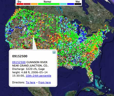
I love sensor webs, and I love the fact that the USGS is making them accessible to us. Their latest effort from March: Real-time streamgages for the US, as a network link. Each dot represents a measuring station. Click on the link in the pop-up, and get detailed granular data.
YubaNet.com has a well-written article on crater chains that follows up on the discovery of craters using Google Earth a month or two ago.
NASA World Wind is up to 1.3.5, geo extensions for SPARQL, a query language for RDF. He’s also written up an XSLT stylesheet that converts these results into KML. Leigh explains: “That allows you to ask questions such as “find points 10 kms from this location” and “test whether a point is within a bounding box”.
This would be an excellent tool for newsreaders to adapt to generating proximity alerts from GeoRSS feeds.
Kathryn Cramer writes that RISE-PAK, the rapid-response effort after the Pakistan Quake to which Global Connections contributed satellite data via Google Earth, has won the Stockholm Challenge 2006 award.
Converjednotes another entry in the race for the enhanced displays we’ll be using a few years from now: Iowa State’s C6.
If you’re registered for O’Reilly’s Where 2.0, and you’re among the first 100 to register here (quickly now), you get to go to Google HQ, socialize and see presentations by Google’s Earth and Maps team on June 12, the day before Where 2.0 starts.
Andrew Hallam at Digital Earth Weblog releases a new version of KML Adapter as open source. KML Adapter is a Java servlet that you put on a server somewhere, and which translates requests from Google Earth network links into a request for an ArcIMS server. This way, if you run an ArcIMS server, you can let Google Earth users get at the data. (Note that ArcIMS servers indexed on Mapdex are automatically made accessible to Google Earth.)
Pierre at Yakofon has already found a use for the RSS to GeoRSS converter. He notes that PubMed queries can be saved as RSS feeds, and so makes a georeferenced feed about bird flu. Of course, it works in Google Earth as well.
As noted in Ogle Earth’s comments already, place directory geonames.org now boasts an RSS to GeoRSS converter that automatically geocodes place names. Even cooler, for our sake, is the RSS to KML converter, which ouputs the geo-enhanced version directly to Google Earth. I tried it on some of my feeds, and it really works.
Juice Analytics checks under the hood of Google Earth and discovers an easy way to modify the user interface, so that you can, for example, float component windows. I’ve just tried this for the Mac version, and it works as well. For the Mac, right-click on the Google Earth application (when it is not running), select “Show package contents”, then navigate on over to:
GeoWeb 2006 takes place in Vancouver on July 24-28. The program has Google’s KML data engineer Michael Ashbridge presenting a 3-hour session on “Google Earth and KML” on July 24, while Google Earth CTO Michael Jones is keynote speaker on July 28.
GPS Watch, a Java app for mobile phones, supports KML export. Are there any GPS devices left that don’t?
The link list running down the right-hand column of this blog was getting somewhat unwieldy, so I’ve given it an own page: Introducing the Ogle Earth link list, containing all manner of resources related to Google Earth, SketchUp, and GIS more broadly.
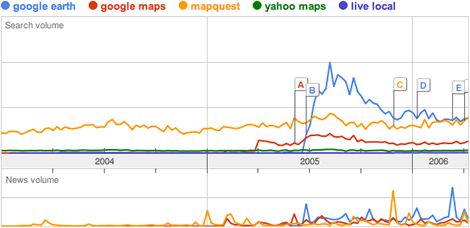
There is a limit of five search terms on a Google Trends chart. “virtual earth” would flatline on the above chart (a blip at launch excepted), as would “mappoint” and “google local”.