While playing with useamap.com for the previous post, I noticed that Sweden now has directions, not just in Google Maps but also in Google Earth. I don’t remember that being the case, and it’s undocumented. Here’s my old route to work, if I had a car. Yay. Still, Eniro.se currently has more of Sweden in high resolution, albeit censored.
Use a map (dot com)
Gorgeous new mashup alert: Use a Map.

Basically, find a spot on Google Maps, then save it as a short URL. A bit like tinyurl.com for places, you might think, except that this is just the beginning:
Give the map a user ID and password, so you can edit it. Then edit the accompanying description or map icon, add a photo gallery (!) or a link, fix the zoom level or map type, decide whether to allow comments and/or password-protect it (if you like).
We’re just getting going. Click on a button to see the view i Google Earth, embed the map on your site using the suppled HTML, email the map to friends, and — the tour de force — click anywhere else on the map to get directions to/from the placemark. Big deal? Sure, as you are just clicking on the map — the web app finds the nearest road and number, and then gets to work finding the route.
Impressive stuff — linking to Google Earth of course helps on this blog:-) (i just wish some of the services, like directions, had their own permalinked URLs, in case we want to link to those.)
Links: SpaceNavigator driver for ArcMap, PlanetOSGeo
- That was fast: Jiro Shirota has written a Space Navigator driver for ESRI ArcMap 9.2, and puts up a demo on Google Video. (Via comments — where would this blog be without comments?)
- Christopher Schmidt is fed up with all those Google Earth blogs on Planet GeoSpatial (apologies all round:-) so he’s built his own planet, Planet OSGeo, focusing on open source GIS blogs. Personally, I like planets because they give me a lightning quick overview of what GIS news has broken, without me having to fire up my news reader and its 1,000+ feeds — I wonder if that sort of informational extravagance is bad for the environment:-) Remember too that anyone can roll their own: Either by siccing this greasemonkey script on James Fee’s Planet GeoSpatial or else using the newly revamped FeedDigest.
- Just wanted to highlight an interesting observation made by GeoLibro a few days back, also noted by the NSGIC blog:
…if the U.S. government is serious about us learning and using the National Grid (USNG), they need to have Google use it for U.S. locations.
This reminded me in turn of the article written about Apple not so long ago in the Wall Street Journal, regarding its burgeoning influence in the music world:
The decisions by the small group of Silicon Valley and music-industry veterans running iTunes can help put an unknown band on the map, adding millions of dollars in sales, while relegating others to the obscurity of the site’s virtual back bins.
It’s remarkable how both Google and Apple have managed to get themselves into the role of a rainmaker in an industry where they had absolutely no presence just a few years ago.
3DConnexion announces SDK for PC, Mac
(Part 2 of the stories I missed last week)
3DConnexion has released a software development kit (SDK) for Windows and announced one for the Mac (due March 30). (A Linux version is already available). This should make it much easier to get 3DConnexion navigation devices like the Space Navigator to work with existing 3D applications — I’m hoping for an expedited plugin for Second Life, but also for Brain Explorer, Celestia and the most excellent PointCloudXplore viewer for the Berkeley Drosophila Transcription Network Project. These are all enhanced reality viewers, and they should benefit greatly from a dedicated navigation tool.
Also this week, 3DConnexion announced its devices now work with NASA World Wind (though we had been tipped off that this was coming by The Earth is Square.
GeoRSS comes to Google Maps
(Part 1 of the stories I missed last week)
The Google Maps API Blog announced support in Google Maps for the GeoRSS data format, a light and standards-based XML vocabulary for georeferencing content in RSS feeds (for example). This means that you can now simply drop a GeoRSS-enabled feed into the Google Maps search box and see the contents displayed geographically.
In the same post, Google also announced that the Google Maps API now supports the loading of KML files (in addition to GeoRSS). This means you can now show KML files on your own Google Maps on your website, as an alternative to displaying them in Google Earth.
Geobloggers’ Rev Dan Catt has a fine expository post on the news, O’Reilly Radar looks at the implications (playing with a GeoRSS-enabled Flickr feed), and Christian Spanring looks at what the next step of development might be: “Maybe GeoRSS feeds getting indexed for searches within Google Earth?”
Knowing that you could once turn a Google Maps view into KML simply by appending “&output=kml” to the permalink URL (alas the trick no longer works), I tried that hack on the permalink URL of a Google Map with a GeoRSS feed attached, hoping for a kind of pipeline to getting GeoRSS converted into KML for Google Earth. No such luck:-) Do remember however that Yahoo! Pipes is very GeoRSS-savvy, so using Google Maps in combination with Pipes should allow for some interesting results.
And finally, as Google Earth already has WMS support (albeit rudimentary), here’s hoping GeoRSS feeds will soon also be supported natively — perhaps as an admissible URL for a network link? As has been pointed out before, GeoRSS and KML do not compete — they are far apart on the ease/power axis of geospatial formats.
Links: Utah geology, Safarri.com, Voozici.com
- Not sure if this is new, but the Utah Geological Survey (UGS) has a series of articles on the state’s geological features which you can also access via a KML file. I really learned something from the well-written, highly informative content presented in nice-looking popups.
And it turns out there really is a Big Rock Candy Mountain! I thought it was just a depression era hobo song.
- Aubrey Falconer writes:
I just released a network link for my classifieds site, Safarri.com, that gathers classifieds listings from Google Base, Oodle (and soon Vast), matches them against any set of filters you specify, and then overlays them on Google Earth as you are flying around!
It is perfect for real estate, but is also fun for lots of other things like boats and cars as well. As far as I know it is the first filterable streaming classifieds overlay for Earth, and it has lots of nice features like one step setup, server side geocoding for a faster user experience, multiple ad providers, streamlined item “boxes”, etc.
- Voozici.com is a new user-generated restaurant, bar and shopping review site for France. All the places are geolocated on Google Maps, but also on a network link, which lets you browse by category (and that’s quite useful). This doesn’t work for Macs just yet, only PCs. (Via Batteries Not Included)
- Favorite quirky mapping site Strange Maps celebrates a milestone of sorts. Congrats.
For Sweden, Google Earth => Eniro.se
For some regions of Earth, there is more higher resolution imagery provided locally for free than what Google Earth can provide. Sweden is one example — here Eniro.se provides unsurpassed resolution (and gorgeous design to boot.)
That why this network link by Perifer.se‘s Anders Fajerson comes in so useful. Whenever you are looking at Sweden in Google Earth, click on the network link to see the same view on Eniro.se. For example:
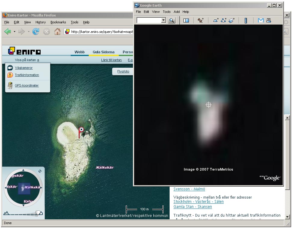
Click on the image to see a larger version. Here’s the permalink to Eniro’s view.
One caveat: The imagery Eniro uses is from a Swedish government agency, Lantmäteriverket, which is a known obfuscator of its own censorship. (At least I can vouch for the island pictured above. I kayaked to it last summer:-)
[Update 21:43 UTC: The network link works for Denmark as well.]