
Google has made available an overlay showing both before- and after satellite imagery of the town of Greensburg, Kansas, devastated by an F5 category tornado on May 4. You can find an animation of the radar imagery that night here.
Google has made available an overlay showing both before- and after satellite imagery of the town of Greensburg, Kansas, devastated by an F5 category tornado on May 4. You can find an animation of the radar imagery that night here.
At a dinner party tonight, somebody mentioned that half of all Dutch people had used Google Earth. I was incredulous. “No, it’s true, I read it on the internet” was the reply. A quick Google later, indeed here is the article in Emerce, in Dutch, dated April 17.
47% of Dutch people have used Google Earth, according to Dutch search engine specialist Checkit and researchers RM Interactive in an annual report they’ve conducted since 2002 on internet habits.
This makes Google Earth by far Google’s most popular non-search product. 90% of the Dutch say they use Google Search; both Google Earth usage and Google Mail usage (at 28%, up from 18% a year ago) are remarkably high. Other products, however, such as Google Mobile, Google Talk, Google Desktop get single digit percentage use, while Picasa manages 11%.
Still, 47%! Who’d have thought that penetration for a standalone downloadable product in a nation of 16.5 million could be that high? The Dutch do benefit from ubiquitous broadband access and a thirst for all things new, so this is a taste of things to come.
Seoul Metropolitan government used high quality 3D Geospatial database developed from a 1 meter digital terrain model , texturing 10cm aerial imagery covering 605 square kilometers(1567 square mile), about one million box-shape simple model for general buildings and 1200 accurate model by using actual picture of the major landmarks.
The accompanying eye candy looks gorgeous.
N95 Corner:
Nokia’s “Project 95” will take Peter Schindler – a seasoned traveler – on a 20,000-plus kilometer, Nokia-solely-sponsored, road-trip across China. Peter will be equipped with various Nokia Nseries devices, most notably the Nokia N95. He will keep a record of his excursions by maintaining a mobile blog that shares his thoughts and images taken through his Nokia N95…
I sure hope that the GPS feature of the N95 gets used to post georeferenced shots, and if Nokia is savvy, that this all gets published as a goodlooking network link.
an experimental twitter client application for the Nokia N95. In addition to some basic twitter functionality it can make use of the built-in GPS of the N95 to add your current position to a tweet. The position can be processed by twittervision and twittermap.
It would be cool if we could get the resulting maps as a KML network link — especially if you could subscribe to the whereabouts of individual users.
Jan Wesbuer in Zumala, Spain, has just downloaded a new build of Google Earth. It’s version 4.1 (4.1.7076.4458 on the PC) — and I while I can’t download it yet for the Mac from where I am, Jan has included some screenshots with his own commentary, below:
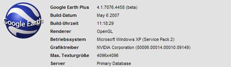
First notice: It has “Tip of the Day”

And Watch in Google Maps Button

Two more new things: GE-Plus licences can now be deactivated. Tours are now playing much smoother.
Time to obsessively start clicking that download button? I wonder if the Mac version will have 3DConnexion support…
[Update: It has 3DConnexion SpaceNavigator support! And also support for a whole slew of languages: Portuguese, Dutch, Russian, Polish, Korean, Arabic and Czech.]
Sean Gorman at FortiusOne writes they had an “overwhelming urge to launch something” in anticipation of GeoCommons and they’ve come up with pollmappr — “syndicated, geographically aware polls” where the results are displayed in Google Earth according to geographic region. It looks great, is thoroughly web-2.0-ified, and is kinda addictive:
The real challenge becomes thinking of a question where the geographic location of the voter is likely to make a real difference:
The geographic regions are US only (at the moment?) which means you need to come up with US-centric questions, and that my vote from Egypt doesn’t count. So I’m voting by proxy (literally, ha) — for the Boston Red Sox.
John Bailey at the Alaska Volcano Observatory & Arctic Region Supercomputing Center sent Frank Taylor and I an information-packed email with heaps of stuff that is bound to be relevant to Ogle Earth readers, so I’m posting it here verbatim, embellished with just a few extra links:
I’d been meaning to email you with a few things that might have flown below your radar (not that much does), and in a couple of cases people have beaten me to it:
- New Scientist: Frank heard about the New Scientist article from a reader. This was but together by Jon Blower as part of the follow-up to the NIEeS workshop he ran in Cambridge a few weeks ago. I was there, and it was an interesting experience — most notably for a chance to compare GE to World Wind to ArcGIS Explorer side-by-side (Note: the KML support in the latter is pretty bad still). Also, as a general theme of workshops to introduce/promote virtual globes to scientists this was one on the first big events, so it was good to see what worked & what didn’t. Look to see further followup appearing on NIEeS GridIndfo, their wiki.
- KML Workshop: The leasons learnt in Cambridge I was able to put into action a few weeks latter at a small hands-on workshop I gave at the GSA cordilleran section meeting. You’ll notice the general layout of the KML exercises is similar to something the Google team put togther (and one of you blogged) and used in Cambridge and other events. I’m giving some internal workshops at the University of Alaska Fairbanks this summer, so I will be improving/developing what I have and keeping it online as a resource.
- Science/Virtual Globes Events: There’s been a rash of conference/workshop events the lately but after ISDE there’s nothing new on the horizon. However, we are planning on putting on events at the AGU 2007 Fall Meeting again. I’ll send you more details when I have them. But in the meantime I update my conferences webpage at least once a month, so if you hear of anything good please let me know.
- Volcano/Virtual Globe Publications: A Geotimes article on Google Earth and Volcanoes (Smithsonian and AVO), was out in print in Feb, and is now freely available online.
- I also thought the following might be of interest as I submitted it a couple of weeks ago, just before Stefan posted his thoughts on KML3.0’s needs: It’s the full paper that accompanies the talk (Telling a story in Google Earth – the 2006 eruption of Augustine Volcano) I’ll be giving at ISDE5. Although the latter [talk] I haven’t prepared yet because who knows what Google or others might produce in the next month!
- And for amusement, if you saw the Wired News article they wrote about me in January, that got picked up in the blogs another time and slightly re-written with an amusing title: Google Fights against Volcano Eruptions (!!!)
- Other Virtual Globe Publications: Wall Street Journal article. I talked with the reporter about this, not really too sure why, I think he was initially planning to go in a different direction.
- An interesting white paper on Microsoft Virtual Earth by Danyel Fisher, who notes that the map servers retain a record of all map tile requests. He says that “Tile server logs are standard IIS logs; they store an IP address, a date and times of access and a URL”. This might not be news in the world of virtual globes, but I’m not sure its been put in a reference-able paper before.
- Random: You may or may not know that Rory Dooley contacted me about giving free SpaceNavigators to all those who presented at AGU… which he did. In return we have been providing feedback. Our friend Valery, since he had one given to him by Google when I took him to visit, gave his to David Ralliant who has been using it in ways it was not intended (as those two are apt to do).
Apparently he was planning to use it at the Virtual Globe Innovations in Paris during the French GIS show GeoEvenement he was part of and has promised to send pictures.
John also points to FeatureServer, which is a server application that lets you upload, edit and publish geospatial data using the REST “architecture”. (What is REST?). Output formats include both KML and GeoRSS, and there is a KML storage demo. Hard-core networking coders seem very excited about REST, so it will be interesting to see how geospatial implementations of it, like FeatureServer, develop.
And if you haven’t clicked on the link to the unorthodox use of the SpaceNavigator, then you’re really missing out on something:-)
Wow, that’s five whole days without posting. I could plead all kinds of extenuating circumstances, but that would take too long:-) Better to just post all the interesting new stuff from the past week anon:
What’s interesting about Twango is that you can send not just photos or videos, but also sound files (and PDFs, MS Office files, XML, Zip…) I would love for Twango to get native ShoZu support, as that would give me the ability to publish automatically georeferenced podcasts/sound recordings to the web using my phone’s built-in GPS. (A Twango API is coming.)
Belgian newspapers that sued Google to be removed from its index are now back in, having agreed to use the commonly-accepted blocking standards that they initially rejected as not being legal.
Silly Belgian papers. At least now there is a legal precedent for accepting the the existing opt-out methods and standards.
Just wondering though, will we have a metadata standard in KML for opting out of indexing or caching (as opposed to the robots.txt method)? Is it possible to publish a KML document today and request that Google not show it as a result of a search in Google Earth?
N95 corner:
Word of warning re the posting frequency here these next 4 weeks: It may get mighty sporadic due to looming project deadlines that are going to have to take precedence…