Category Archives: Uncategorized

Google Earth Enterprise: Where does it fit into the GIS landscape?

The main new feature in the latest version of Google Earth Enterprise, announced on Thursday, is that the Google Maps API engine can be run by corporations on their own servers, so that geospatial data can be served privately and securely to a web browser, without needing to use Google.com.

What I think is interesting here is that over the past two years users of the free Google Maps API have in effect been beta testers for the enterprise version. Not that there is anything wrong with that:-)

Adding the ability to publish geospatial data via one’s private Google Maps API changes the competitive landscape somewhat. I asked Brian Flood how/if this most recent announcement has repercussions for Arc2Earth, a tool for exporting ArcGIS data into KML and mapping APIs including Google’s public Maps API. After all, Google Earth Enterprise also lets you publish KML superoverlays, so nominally, there are some overlapping functions. Here’s what Brian had to say:

Arc2Earth (as it was originally intended) is more for desktop ArcGIS users, the people who do not have servers, server software or the budget to buy them. In this regard, we will continue to have customers who want nothing more than quality import/export/publish of their ArcGIS data. Amazon S3 allows them to internet-enable their data very inexpensively, so this is also a big draw.

Google (for their Enterprise offering at least), MS and ESRI seem to be concentrating on big corporate users, as they should, that’s where the money is. I’m not sure where this will leave the middle tier users in the short term although I could see both providing “mashup” tools that could catch on for small, ad-hoc projects.

So, how do I see A2E fitting in going forward?

  1. Complimentary tool – We have several A2E clients using it as part of an overall workflow. As an example, one is a premier Google Enterprise site and they ended up getting a site license for A2E so all their ArcGIS users could publish KML files to a server location. The rest of the end users then got these updates automatically in GE via Network Links. In this regard, we are just part of, not the whole of the process. A2E Enterprise has the scheduler and command line tools for exporting tiles and kml, so this is great for batch updates and would work well alongside of any other enterprise products.
  2. New features – I think we keep pushing some of the boundaries of KML and tile creation. We have several custom projects that create millions of tiles a month. Also, when V2 of A2E is released (hopefully in August) we will be offering some cool new features. Vector regions, shared KML documents on S3 and many other goodies. Here’s a quick sample that shows vector data clipped to each region (which solves the large polygon with fill issue). There are still some issue with region activation and panning but this will be resolved before V2

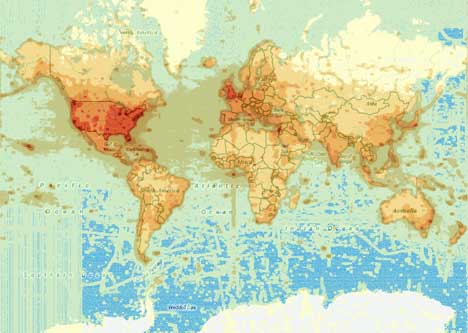
    109th US Congress – ESRI Census data, entire US

    Somerset County Parcels 500,000 parcels (zoom straight in)

    Also, our implementation of regions has always been a little different than others as well, by using a uniform grid we can update portions of the whole at any time (a big feature for many of our users with large datasets who do not want to re-export everything).

  3. ArcGIS formats – this is more in relation to Goog and MS but A2E will export anything that can be viewed in ArcGIS, my guess is this will be a lot more than their offerings, so having A2E as part of the workflow helps for the more complex data.
  4. Lastly, as always, there are many people who cannot afford servers or server software at all. They have ArcGIS and need to get their data out there, this has been and will continue to be a great arena for A2E

Coming up next: The human sensor web

Suddenly it is all so clear: The next big corporate race is going to be getting the biggest mobile crowdsourcing network.

It’s been obvious for a little while that mobile location-aware communications devices like the Nokia N95 will be ubiquitous five years from now — they’re the Star Trek Tricorder meme made real (though the UI will look more like the iPhone’s, I hope). What wasn’t so obvious (at least to me, until this week) is that these devices will make great georeferenced information collection networks, perfect for data-mining. The corporate challenge: Building, buying or otherwise gaining access to such a network.

The evidence (and a blind alley):

There have been two acquisitions that have been widely reported in the GIS-o-sphere this past week: GPS device maker TomTom’s planned acquisition of digital mapping company Tele Atlas and Google’s acquisition of aerial imagery provider ImageAmerica.

(Google’s purchase has generated a lot of press but is the least relevant to this story: The company has been renting the services of aerial digital imagery providers (in the US and also in Australia) and I suspect it is just cheaper to own the planes and cameras if you plan on updating the most viewed regions more often. It’s a logical next step in Google’s mapping mission: it increases their ability to generate new imagery quickly without having to depend on a third party to allocate resources as they see fit. (That, and Google Earth CTO Michael Jones loves gigapixel cameras:-) )

The TomTom-Tele Atlas merger presages the coming of such geospatial collection networks, and newly minted Googler Ed Parsons sees its implications right away:

Without community generated content, in a online future it will not be possible to provide the expected level of currency of data – Strong stuff but hard to argue with.

Daily Wireless excerpts a Newsweek article that struck me: Both Tele Atlas and competitor NAVTEQ already employ hundreds of “road warriors” in the field to gather data that satellites can’t catch: traffic signs, one-way streets, points of interest…

“At the end of the day, there’s no substitute for going out there and capturing the real world ourselves,” says Navteq CEO Judson Green.

How to scale that? Build a crowdsourcing network, so that others can capture the real world for you — using devices that companies like TomTom (and Garmin, and Nokia) can build.

Geospatial crowdsourcing already has a impressive working example: OpenStreetMap.org, where you can (manually) upload your own GPS tracks to create a collective world road map or edit existing data. And now it turns out that Google has been piloting something similar in India, as explained by Michael Jones last week at a conference. Dan Karran has transcribed the relevant bit of Michael Jones’s talk:

We have a pilot program running in India. We’ve done about 50 cities now, in their completeness, with driving directions and everything – completely done by having locals use some software we haven’t released publicly to draw their city on top of our photo imagery.

From static to live

So far we’ve only been looking at collecting data with a long half life, such as the locations of gas stations and roundabouts. But when there are enough human “sensors” in the network, Michael Jones explains,

[…] it has the advantage of, when the road is closed, you can click on that road and say it’s closed today. If you’re having a block party, you can say the block is closed this day. Traffic data that’s up to date every day.”

Google’s solution doesn’t (yet) involve the use of a mobile gadget to contribute live data, but such solutions already exist elsewhere. Already in 2006, new Honda Civics driving on Japan’s roads could wirelessly upload live telematics data to a central server to calculate road congestion. For a fee, you can get that information delivered to your car dashboard.

Getting location-aware mobile devices to contribute data to such networks means less work for humans, as there is no need to manually georeference the data. The easiest milestone on this road (pardon the pun) is live traffic reporting, as it doesn’t require the active participation of a human beyond driving. In the future, if TomsTom get the ability to transmit live telemetrics on busy highways via wireless data networks, you might start saving lives if a traffic accident in dense fog involving a TomTom-equipped car is reported in time to those following soon after.

Traffic monitoring may be a special case — cars are nearly always in the line of sight of GPS devices, whereas humans are more often than not inside, or in a concrete city canyon. So how to get humans to actively contribute to a georeferenced crowdsourcing network, other than by paying them, which isn’t scalable? You could appeal to their nobler selves (the open source model), you could make it fun (Google Earth Community), or you could appeal to baser motives — let the contributor get something out of it, such as access to the collective wisdom of the network (for example, to find the rooms with the best views in hotels as reported by previous visitors). But above all, it should be easy for the contributor.

This is where this week’s under-reported acquisition plays a part: Nokia bought Twango. Twango is a media sharing web application for mobile devices. Unlike its main competitor Shozu, which offers to forward your media to your web sharing app of choice (such as YouTube, Flickr and others), Twango wants you to store all your media in one place, on its servers, and share it using its URLs as a destination. With Twango soon installed by default on new Nokias mobiles, Nokia will be making a play to capture the generated media of its hundreds of millions of mobile phone users, so that network effects are its to dispense — with uploaded videos and photos providing eyeballs to advertisers.

Shozu gives users more choice when it comes to which network they want to contribute to, and I hope that this is the model that catches on, as it is in the users’ best interests to have device agnosticism when it comes to networks, and network agnosticism when it comes to devices. Meanwhile, Shozu already georeferences images for you if you have a GPS-enabled phone, though presumably Twango will soon follow — at the moment you have to tag for places manually.

So: Car navigation devices are going to communicate data in both directions, live; mobile phone manufacturers are going to load their phones with default software in a bid to capture and host the generated media; and other network web apps are going make sure they have APIs to which these devices can post, perhaps even automatically. With Nokia’s GPS phones already providing a fee-based navigation service, it’s inevitable that all these manufacturers are converging on devices with similar functionality, while the information gathered from these gadgets is going to be valuable to whoever gets access to them.

International Polar Year, now in glorious KML

This past week I’ve been putting the finishing touches on the new KML layers for the 4th International Polar Year (2007-2008), and they have now gone live over on IPY.org. Download the main layer here; it comes in two parts:

  • A tour of IPY across both polar regions, written by University of Alaska Fairbanks’ Matt Nolan, and
  • A network link to a file containing the most recent 50 or so georeferenced stories posted to IPY.org by scientists in the field. These stories are identical to the ones published to the site, and you can see exactly where they were written.

It looks like this:

ipyann2.jpg

ipyann0.jpg

This main layer is meant to be the most accessible part of IPY’s content for Google Earth, but there is a lot more available for those who are polar enthusiasts, professionally involved in IPY or who like to look at raw data:-) From the main layer, you can click through to three additional resources:

  • A tour of IPY projects: This KML file is set up as a guided tour of all 240 endorsed projects taking place during this IPY. It was created by pulling information directly out of the IPY project database. (By Matt Nolan)
  • Useful polar layers: A web page collecting links to relevant polar-themed KML files I’ve found on the web. (If you know of more, let me know and I will add them.)
  • Learn more about an IPY project: This is a KML file collecting detailed information from scientists about their individual IPY-endorsed projects, and it even includes raw data. To kick things off, Matt Nolan has created an extensive layer on the Glaciodyn glaciology project, which includes his work on Alaska’s McCall Glacier.

ipyann1.jpg

Over the past few months there has been a burgeoning interest among polar scientists in getting their IPY project published to virtual globes like Google Earth, and we’ll be adding their research results and outreach efforts to these layers as they become ready. In the meantime, there already is plenty to explore:-)

GMap-Track does KML

If you’re using GMap-Track to publish your location live to the web, here’s a quick cool hack in anticipation of the release of the API. A GMap-Track URL can return KML instead of a Google Maps-based placemark, like so:

http://www.gmap-track.com/api?v=1.00&output=kml&method=location.get.user&getuser=ogleearth

Just be sure to first wrap that inside a network link, like so. Voila, now you can find out where your friends have been recently when you log onto Google Earth. (Thanks to GMap-Track’s Cristian Streng for for the tip.)

Censorship coming to South Korean Google Maps?

South Korea’s government has long been unhappy with the transparency that Google Earth and Maps provides over South Korea (though it doesn’t mind the view of North Korea one bit). Now South Korea’s mainstream news site Chosun.com carries an article that seems to indicate things are coming to a head:

Google Korea said on Sunday that it is in talks with a government agency about security measures in regards to the exposure of national security facilities in satellite photos provided by Google Earth.

A source at Google Korea said that Google’s policy is to show original materials as they are, but, given Korea’s current situation, the satellite map provider will fully incorporate the Korean government’s demands when it starts its Korean satellite photo service in the future.

Whatever could that mean — a “special” censored version of Google Maps, not unlike the way that China’s Google Maps is “special”? Censoring South Korean imagery just for South Koreans would be a phenomenally pointless act, but if that is what keeps the government happy, that’s fine by me:-) Or is the source implying that the next generation of imagery will be censored for everyone?

Mapping the mappers: Usage stats get mapped

Dan Karran reports from the State of the Map conference held in the UK this past week, mentioning that Google’s Ed Parson’s showed off this map detailing where the most user-generated content was posted on Google’s geodatabase:

geuser.jpg

Quite by coincidence, this past week also saw Microsoft’s Danyel Fisher show off a map of something not entirely unrelated: Usage patterns for Virtual Earth, based on how often a tile is requested:

veusage.jpg

That’s an image I grabbed from Hotmap, Microsoft Research’s resource for this data that just right now appears to be down.

What can we tell from these two maps? That the UK is a popular geosurfing destination and simultaneously a major location for user-generated content, whereas India and China are woefully undermapped by users relative to the population — certainly relative to Southeast Asia — although viewing interest in those two regions appears healthy.