Category Archives: Uncategorized

SketchyPhysics

SketchyPhysics, a plugin for SketchUp (Windows only): I had no idea that adding a physics engine to SketchUp would be so easy (for us users), or produce such fun results:

That looks a lot smoother than Second Life’s basic physics engine, though perhaps not as scalable. Still, Google Earth + SketchUp + SketchyPhysics + avatars, and we’d be having heaps of metaversal fun. I don’t think it’ll happen anytime soon, but all the building blocks are getting there. (Via Think in Pictures, which has more YouTube videos to show you.)

Google to Mobile GMaps: No tiles for you

This sucks. Cristian Streng, developer of Mobile GMaps — the most feature-rich and robust mobile mapping application I know for J2ME-capable phones — has been sent a cease & desist letter from “Google Enforcement Team”. Google only lets you use mapping tiles from Google via the API. But the API is javascript-based. Mobile phones don’t do javascript. Ergo no Google Maps-based tools allowed for mobiles… unless you use Google’s own (barebones) application, of course.

Cristian has now complied with the letter of the law, if not the spirit, as he’s removed the Google Maps option from the most recent version but also made it possible for the end user to now define any base URL for a tile mapping service like Google’s. (This reminds me of online “crossword” games where you have to build your own Scrabble ™ board.) Hack the Day has the settings for getting Google Maps tiles in the new version if you are so inclined.

One highly ironic result: You can now only legally view KML files on your mobile on top of Yahoo Maps and Microsoft Live Local.

It’s Google’s tiles and they can of course set the terms however they want. But it’s undeniable we have ourselves a sub-optimal outcome here. Google should consider doing one or more of the following:

  1. Build a mobile mapping client that makes me want to switch from Mobile GMaps to Google Maps Mobile. (KML support? Live web tracking?)
  2. Hire Cristian Streng.
  3. Amend the API or their terms of use so that the mashup revolution can go mobile. Third parties need to be able to thrive on mobile platforms too.

That last point is very important. In an ideal world, people would simply start adopting more lenient mapping services for their mobile apps, and these then get the benefits of widespread adoption, but the real-world problem is that outside the US, high resolution satellite imagery by Google’s competitors is atrocious. In places like Egypt and elsewhere, Google’s imagery and maps are the only game in town.

In other Mobile GMaps news, KML output has been improved if you want to do live tracking with GMap Track. Simply point a KML network link to:

http://www.gmap-track.com/user.php?user=ogleearth&output=kml

You will get a placemark for your last location — and now also all the metadata that comes with it.

Links: MyGMMS; GE update details, real-time govt data?

Continue reading Links: MyGMMS; GE update details, real-time govt data?

France’s Géoportail does 3D if you do Windows

Last summer, amid much fanfare and little server capacity, the France’s National Geographic Institute (IGN) released Géoportail, a 2D web mapping application that was (inaccurately) self-described as France’s answer to Google Earth. A 3D version was promised for 2007. It has now arrived.

Géoportail 3D is built upon Skyline Software’s Skyline Globe web browser plugin. Here’s comes my first complaint (what did you expect?): The plugin works on Windows 2000/XP/Vista only, which once again defeats the point of using a web browser to serve the data. (At least there are more Windows options available than the BBC’s XP-only iPlayer for BBC video.) [Update: Mac and Linux will be supported in January 2008, says IGN.] Second complaint: It is slow. On the plus side, the 3D version is clearly marked Beta — which means that these complaints are provisional:-)

geo3d.jpg

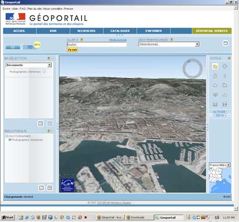
Also no sign yet of the 3D buildings with facade mapping that was demoed back in April 2006. Meanwhile, Google Earth just got new high resolution imagery this past weekend for the French Riviera, Arles, Biarritz, Strasbourg, Grenoble, Angers, Amiens, Bourges, Clermont Ferrand, and the Loire River.

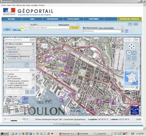
But some compliments are in order for the 2D version of Géoportail. Over the past year it has gotten some nifty features, including the ability to adjust the opacity of different mapping layers — for example having the imagery at 100% on the bottom and superimposing the map at 50% on top of it.

geo2d.jpg

Still, the interactive mapping tools that Google MyMaps has made available over the past year makes Géoportail feel so, I don’t know, 2006? What IGN should have done, and what they still could do, is to make their mapping layers available to all comers, be it Google, Microsoft or NASA World Wind, and let them deal with the cut-throat competition of building compelling consumer mapping applications. That’s a completely separate skill from collecting and prepping geospatial data, which is what IGN specializes in, and what it should continue to focus on. IGN is not the French Google, and never will be. (Via Business Garden)

Links: KML to VE? Data update for Google Earth; Bliin

  • KML coming soon to VE? Microsoft Virtual Earth will support KML by October this year, reports Geothought from the GeoWeb conference in Vancouver. As recently as ISDE5 in June, a VE developer was non-committal on the topic when asked.
  • New data for Google Earth: Google Earth’s dataset has had an update, but Google’s LatLong blog is being coy about what precisely has changed. Digital Earth Blog steps up with some updated regions. Highlight for me is the fantastic DEMs for New Zealand and high resolution imagery of Timbuktu.
  • Social positioning: Bliin (beta) is a “location-aware real-time social network”, a very slick competitor to Twango that lets you share text, photos, sound and video with your mobile gadget, as well as update your location live (with a track) — and all of it commentable, giving it a Twitter-like feel. There’s more – The mobile application has a proximity sensor for other people’s georeferenced shared media, there’s privacy settings, integration with OpenStreetMaps.org, trip recording… Don’t have a mobile? There is client for desktops as well. Downsides right now: No API to reuse the info elsewhere, and no KML output.
  • Graphic Converter 6 for Mac ships. What It comes with the ability to set the EXIF coordinate metadata from the current view in Google Earth.
  • En Español: Google Earth Blog now comes in a Spanish version. Yo la tengo, as they say in Belgium:-)
  • Not free, no good: I have no idea why anyone would pay $15 for Phone2Gearth (for Symbian S60) when Nokia’s Sports Tracker does the same stuff for free.
  • HoudaGeo reverse geocodes: Photo geotagger HoudahGeo for Mac is up to version 1.2, adding among other things the ability to reverse geocode from coordinates to placenames, which is great for adding better metadata, faster.
  • Video + GPS: Cool demo of Microsoft’s Silverlight web app-building technology incorporating a GPS track, video and Virtual Earth.
  • Google SketchUp for Dummies is out, with its very own website full of videos that you can use even without the book.

Google Earth causes qibla quibble

Italy’s Il Corriere della Sera has an article sourcing Saudi Arabia’s al-Watan about how Google Earth has been used by researchers to check up on the orientation of Saudi’s main mosques, only to find that some are not facing in the direction of the qibla, i.e. Mecca.

There is no compulsion for mosques to face qibla, but many newly-built ones do so anyway in order to serve as an aide in prayer. (You need to face Mecca when praying.) My Arabic is not nearly good enough to find the original article, let alone translate it, so here’s the gist from the Italian version:

The culprits are the architects, apparently, who were too lax in their calculations. Saudi researcher Abelaziz al-Ghamidi tells al-Watan that in al-Bahah province alone, 15 mosques were constructed in the wrong direction, among them the central mosque of al-Bahah City. Al-Ghamidi has been using Google Earth for two years now, checking on each and every mosque in Saudi Arabia.

Upon al-Ghamidi’s discovery, the Saudi ministry of Islamic affairs got involved, and it determined that the errors were limited in scope, and thus would not have impacted the validity of the prayers.

I went looking for some mosques in al-Bahah City, and checked up on the two largest I could find:

mosque1.jpg

mosque2.jpg

My conclusion? I think al-Ghamidi has far to much time on his hands.

(Want to find out what direction qibla is where you live? Google Maps-based Qibla Locator to the rescue! Now if only somebody would make me a map that shows the direction of Darwin’s grave.)

Cheney: The censorship that isn’t

I’m in London. I meet a friend for lunch and am told, conspiratorially, that Dick Cheney is actually running the US government because while you can see the White House in detail in Google Earth, The Naval Observatory where Cheney lives is pixelated. Who says, and what’s one got to do with the other, I ask? “The Guardian wrote that in an article,” I am told. Sure enough, here it is in a piece from last Monday, which begins:

Is this the real president of the United States?

He rarely speaks in public and closely guards his privacy. But there’s a growing consensus in America that it’s Dick Cheney who calls the shots at the White House, on everything from the war in Iraq to climate change policy. Ed Pilkington reports

Monday July 23, 2007
The Guardian

It is a party trick well known to curious teenagers across America. Zoom down on Washington via Google Earth and you get an extraordinary eagle-eyed view of the world’s greatest powerhouse. There’s the White House and its West Wing. There’s the spot where they put the national Christmas tree festooned with lights. Sweeping south-east across the Potomac you soar above the pentagon of the Pentagon; then back up a bit north and you can sit for hours counting the tiles on the roof of the Lincoln memorial. But there is one thing you can’t do. If you scroll over the site of the vice-president’s official residence, all you will see, mysteriously, is a blurry fuzz.

The 46th vice-president of the US, Dick Cheney, has a fondness for remaining invisible. It doesn’t matter whether it’s Google Earth or a bank of television cameras, he won’t play ball. He rarely presents himself to the media, and when he does so he likes to keep it in the family.

I think we can safely conclude that it is now received wisdom that Dick Cheney has had that imagery censored. After all, not only have Maureen Dowd and Jon Stewart said as much, we now have reputable British newspapers stating this as a fact. Never mind, of course, that you can buy uncensored versions of the imagery for $35 online, or for $0 if you are willing to live with “preview” watermarks. Google is just using an outdated dataset, is all.

It’s sort of depressing to watch a lack of understanding about how such imagery is captured, processed and published turn into an baseless urban legend, mostly among those who at the same time accuse the Bush administration of having rushed to judgment on Iraq without first considering the evidence.