Category Archives: Uncategorized

Georeferenced airport YouTube vids, now in KML 2.2

It’s a little hectic here but that shouldn’t keep me from forwarding great new examples of KML 2.2 in action. Writes EarthNC‘s Virgil Zetterlind:

I’ve published a sort of fun YouTube Airport Videos KML here. It uses the embedded video support of v4.2 in windows, but also provides the video links for Linux/Mac users. Besides the video support, I’m using the new KML 2.2 KML linking options to support navigation between videos of the same airport without ‘spamming’ placemark icons.

The file was created by running a ICAO airport identifier search against the YouTube API. As such, it’s subject to errors and it misses a large number of videos due to poor tagging. Here’s hoping that over time more people will use the geotagging options on upload and that Google will better expose geotagged results via the YouTube API.

PhotoOverlays for everyone, using built-in controls

Valery Hronusov has been playing with Google Earth 4.2 beta’s implementation of KML 2.2, and has come up with a couple of things worth sharing:

Flash: On Windows machines (but not Mac and Linux), you can embed a whole Flash applet in a placemark popup balloon (not just YouTube videos), and it will work just as if it were in a browser.

Webcams: This works on Mac, PC and Linux versions of 4.2, so it is immediately useful: Have a <PhotoOverlay> point to an image generated by a webcam, and set the <refreshInterval> tag to the same interval as the webcam’s interval. Voila, a webcam image that is perfectly positioned:

webcam.gif

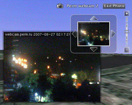
(Notice how the small thumbnail image refreshes as well.) Here’s the specific snippet of code that Valery used to get a one-second interval refresh rate:

<Icon>

     <href>http://www.url.to.image.jpg</href>

     <refreshMode>onInterval</refreshMode>

     <refreshInterval>1</refreshInterval>

</Icon>

This is definitely the way forward for georeferenced webcam images. (Remember that if you want to check out the KML code for yourself, just select a placemark, choose the Copy menu item and then Paste into a text editor. You’ll get the KML code.)

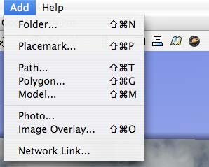
While playing with Valery’s placemark I found something this blog has overlooked until now:

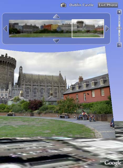
Built-in PhotoOverlay controls! It turns out that rolling your own PhotoOverlay is not nearly as difficult as I had assumed. There is no need for a highly sophisticated robotic camera positioning system to record the heading, tilt and roll of a shot (though I still want the future camera that will record such data automatically as EXIF:-) — instead, just use the new Add > Photo menu item:

menuphoto.jpg

You then get a wonderful control panel for editing every conceivable parameter of the photo you want position:

pogui.jpg

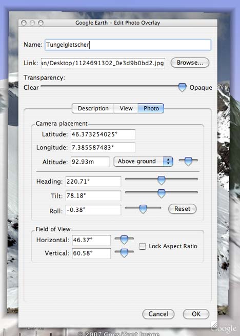
I used the normal camera controls to get into a rough position, and then used the fine-tuning controls on the panel, which are very sensitive indeed. Especially nice is the ability to unlock the aspect ratio for the field of view. In my case, the end result proved quite respectable, for a quick effort:

finalpo.jpg

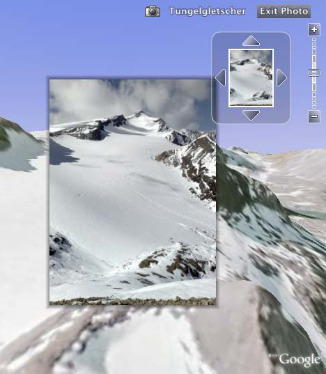
While I am sure you are by now completely sick of my Alpine trek pictures, such landscape photos are practically crying out for the PhotoOverlay treatment. Luckily, I am going to be very busy this coming week so I doubt I’ll be able to subject you to any more PhotoOverlay-enhanced holiday snaps for the foreseeable future:-)

All this does imply the question: Might there not be a way to go and update Panoramio photos with an enhanced PhotoOverlaid version soon? If everyone takes responsibility for their own shots then we’ll be done in no time:-)

Finally! Show Flickr sets as KML, on Google Maps

This made my day. Adam Franco writes:

Reading your post recapping your usage of Flickr photos in Google Earth/Maps reminded me of a small bit of code I had written a rough version of last year, but had never gotten around to cleaning up: a Flickr API script that converts all of the geotagged photos in a Flickr photo set into a KML file with a few options.

I’ve posted more details about the script on my blog and thought that you (and your readers) might be interested.

This is exactly what I’ve been wishing for, and it works wonderfully. You can choose the size of the photos in the popups, and you can even draw a path between the photo locations, based on the date taken, date uploaded or the order of the set. Using my set of georeferenced pics from the Alps, then:


View Larger Map (or get KML)

Adam’s PHP script lets you download the KML file directly or else open it in a Google Map. I did the latter, and then embedded the map to get the above result. On the larger map there is always a link to the KML file.

Adam has made the PHP script available under GNU General Public License (GPL), so you can download it here and run it off your own server if you want.

Links: Flash in GE Windows only for now; Metropix; Morocco censorship

  • No embedded video for Mac, Linux for now: The KML 2.2 reference documentation notes that “In Google Earth 4.2, video is supported” and goes on to show sample code for embedding YouTube video in a placemark. Unfortunately, word from informed people is that only the Windows version of Google Earth comes with the requisite embedded Flash player. “Mac & Linux do not have this, and won’t for some time.” This definitely dampens the incentive to go make KML with video content in it, as it would break the cross-platform compatibility that Google Earth 4.1 enjoyed with KML 2.1.
  • 2D floorplans to 3D KML: Metropix has a novel idea that I would never have thought of. Writes Metropix’s Max Christian:

    GE has been used for real estate since back in 2005 of course, but the new aspect is that we have developed technology to generate furnished 3D models in GE automatically from 2D floor plans. We produce thousands of floor plans per day for real estate agents, so this will lead to quite a lot of 3D models quite quickly! There’s more information here.

    Amazon Web Services Blog also writes them up today as another fine use of their S3 scalable server service. The result is impressively detailed KML (though I can’t vouch for its accuracy) :
    pixome.jpg

  • Spreading risk spatially: Allianz Global Corporate & Specialty Insurance of Munich makes sure to spread the risk. Literally. Using Google Earth. Here’s how they do it. (Via Econdev20.com)
  • Morocco’s censorship of Google Earth continues: More than a year later, Google Earth is still censored in Morocco. Francophone Motic blog has an in-depth round-up of local reactions, but concludes, depressingly, that “The censorship of Google Earth in Morocco has lasted for over a year because the majority have chosen to accept it rather than to denounce it.”

    Given that the Google Maps API provides the same data (albeit in 2D) and given that any URL can now embed a Google Map, surely somebody can point out to the Moroccan government that they’d need to close down the internet if the intent is to prevent this imagery from ever being seen by Moroccan residents.

  • Multitouch demo: More Jeff Han multitouch display pr0n, on YouTube, featuring some good geospatial candy. (Thanks giasen!)

Putting Google Sky to work: Real-time astronomy via KML network links

Here’s why Google Sky is going to change astronomy as we know it: Because an astronomer like Alasdair Allan can spend an afternoon converting an astronomical events feed into KML, and suddenly millions of Google Earth clients can spatially visualize these.

His events feed project, VOEvent, has its home page here, whence you can now get a live KML network link for Google Sky.

Alasdair, writing on his blog The Daily Ack, also points us in the direction of Caltech’s VOEventNet project page which collects real-time feeds of astronomical events (such as his own) of gravitational microlensing, gamma-ray bursts and x-ray bursts — as of today, all these events are also available as KML network links. For example:

ogleevent.jpg

Suddenly, the sky has turned into a huge canvas, ready to be updated in real time via KML.

(Alasdair has more insights in this comment to the previous post on Ogle Earth.)

Links: Bad Sky? KML for Sky reference, Embedded Google Maps for WordPress

News specifically about Google Earth version 4.2:

  • Bad Sky? Bad Astronomy, the alpha male of astronomy blogs, gives the Sky functionality in Google Earth a mediocre review. That’s because there are several other sky viewing applications out there today that do a better job than Google Earth currently in rendering the sky (check out Stellarium, the web-based sky-map.org and the fly-through Celestia.)

    Where Google Earth/Sky shines, on the other hand, is in the annotatability of the presented data, and in the ability to let you overlay your own data via KML. Back in the early days of Google Earth, the GIS-industrial complex took a long time to understand that Google Earth prioritizes easy content creation and sharing, and that this is its main attraction. (I see that Davep’s Astronomy blog makes the same point, and additionally provides some concrete examples of how astronomers can share observation logs.)

    We’ll have to do a proper comparison of all these apps in the near future, and see where the relative strengths and weaknesses are. Luckily, my first love was (and remains) astronomy, so you’re in good hands right here on Ogle Earth:-)

  • Web-based Sky? Talking of sky-map.org: Google Earth is to Google Maps like Google Sky is to … ? I’ve been checking during the day whether there might not show up a web-based equivalent of Google Sky at sky.google.com, but no luck…
  • Google Sky content contributors: Who were Google’s content partners in bringing the Sky to Google Earth? Google lists them here. It’s a long list with links onwards.
  • Google Sky reference links: A resource page by Google about the Sky feature points to a new Google Earth Community forum about Sky. On it you get some interesting bug reports: Here Saturn occults Mercury! (Quite a feat:-) The resource page also sports a YouTube intro to Google Sky. Finally, here is the simple user’s guide for using Sky while here is the advanced KML reference for those who want to put sky data into KML (must-read).
  • PhotoOverlay reference links: There’s also an advanced KML guide for using the <PhotoOverlay> tag and one for setting camera angles.

News not specifically about Google Earth version 4.2:

  • Embed Google Maps via WordPress: Daniel Denk of Remote Sensing Tools has created a Google Maps plug-in for WordPress that lets you quickly build a map and grab the embedding code while blogging:

    While editing your post, you can quickly pop-open Google Maps from the editor and generate your map through the Maps interface, or quickly grab the link to a map you’ve already prepared in My Maps. Then, you can copy the code given for embedding and paste it directly into your editor.

    Fantastic. The YouTubing of Google Maps continues apace:-)

  • Google job: Google is looking for a technical writer in London. “Have you downloaded Google products and services such as Google Earth just to play around with them? If so, send us your resume!” I wonder if they would let me work out of Cairo:-)
  • Unype + Facebook Unype, which previously let you turn Google Earth into a multi-user environment via Skype (for Windows), now lets you share the space with fellow Facebookers, via an app using the Facebook API.
  • Cartoweb KML plugin: exportGge: “A KML export plugin released under GPL license for Cartoweb, an open source web mapping solution working on top of UMN MapServer and written in php5.”
  • ArcGIS Explorer goes underground: Re ESRI ArcGIS Explorer’s latest build: It does subsurface navigation, reports Location Based Soup. (Via James Fee Blog). I wonder who’ll be first to do 3D rendering of bathymetry data…
  • Geo uses for Amazon S3: Amazon Web Services Blog has an interesting post about all the webistes that are using Amazon’s scalable S3 server to serve map tiles and KML files. It mentions WeoGeo (beta), a site that I had not previously come across which calls itself “a one-stop marketplace for mapping. It supplies surveyors, engineers, cartographers, and scientists with the ability to conveniently store, search, and exchange high-resolution CAD and GIS mapping products. Mappers easily list their data for sale. Researchers quickly find the data they need.” It’s all KML savvy.
  • Leica + Microsoft: Leica TITAN, a GIS filesharing and messenger service that lets you share GIS data on a virtual globe, announces that data can now be shared on Microsoft Virtual Earth 2D and 3D. Find out more here.
  • Grauniad sics OS: Missed this before: The Guardian covers the story of the UK Ordnance Survey nixing the licensing of data that would have made a 3D model of London in Google Earth possible.

Gigapan.org puts KML 2.2’s <PhotoOverlay> tag to work

The Gigapxl Project that is part of the newly updated default layer for Google 4.2 beta isn’t the only content out there that is taking advantage of the new KML 2.2 tags, specifically the <PhotoOverlay> tag, which lets you accurately position high resolution photograps and the viewer’s perspective so that the image fits in with the surrounding lanscape.

Gigapan.org, another gigapixel sharing project, has also georeferenced their photos and is now providing the KML network link for download.

dublinc.jpg

Gigapan.org is the photo sharing site of the Global Connection Project at Carnegie Mellon University/NASA Ames Research Center, and Randy Sargent — who is a project scientist there — writes:

Anyone can upload a large panoramic image (50 megapixels minimum), click on “Place in Google Earth”, and you can adjust the panorama’s orientation and field of view until it’s correctly placed. gigapan.org does all the work to convert to something that’s viewable in Google Earth :-)

It looks like all this will soon be automated, at least for the dedicated amateur professional: there is a whole page dedicated to a soon-to-be released robotic mount for digital cameras that records the orientation and angle of the camera when a photo is taken. It looks suspiciously like the mount of my Celestron telescope:-) but that would certainly provide what’s needed to record the requisite data to feed a <PhotoOverlay> tag.

Some further panorama-themed notes:

  1. The image zoom and movement controls are accessible to all content within <PhotoOverlay> tags; it is something everyone can use via KML, and not a Google-specific tool (as I had guessed this morning).
  2. <PhotoOverlay> tags can deal with flat 2D images, partial or full cylinders, and also spheres.
  3. The functionality is still buggy for me, running 4.2 beta on a Mac. Sometimes the larger image is upside down, sometimes it disappears, and quite often it doesn’t resolve when zooming in. I’m not sure if this is because of load on the servers, or if it will require an update. Is it working well for PCs? I should boot into Windows sometime… but life is so short!
  4. Remember the much-promoted news from December 2006 where Pennsylvania announced it would use gigapan technology to make panoramas of US Civil War views? Well, now the technology is in place, so we can start expecting something to happen on that front…
  5. So is gigapan.org like panoramio on steroids?:-)