- International Polar Year news: It’s Ice Sheet Day today! Over on IPY.org, see participants in schools and at scientific institutions put a pin on a Google map to mark their participation. Meanwhile, news today that the Western Antarctic Ice Sheet is about to turn into a GPS-enabled sensor web. Greenland got sensors last summer — you can read the Greenland scientists’ blog entries on IPY.org, or you can download the IPY KML layer, zoom in on Greenland, and browse the blog geographically.
- Sky Maps coming soon: Being finalized in the Google Maps API Group: Google Sky’s data accessible via the Maps API, ready for embedding in your website.
- Murder in Melbourne: The Age writes:
Police are also hoping a Google Earth van, which has been tracking the suburb, can shed more light on the mystery.
It’s a long shot, but interesting lateral thinking. The Australian Associated Press article manages to mangle that news bit completely, though:
During forensic work at the crime scene on Wednesday, police were approached by a Google Earth operator who had been tracking the area by satellite for the past week.
Technoramuses make bad reporters these days. (Thanks, Michael)
- Earth nearly live: NASA’s OnEarth: Real-time updated global MODIS, as a KML file. “This layer is the most current, near-global image of the earth available.” (Via Mikel Maron)
- Multimap 2 MSFT: Microsoft by the UK’s Multimap for $50 mln, says the Times. Why? The Times intimates it’s a quick way for Virtual Earth to grow UK market share and get some local content.
- Flickr Places redux: Dan Catt elaborates on the thinking behind Flickr Places, and also links through to developer Kellan’s blog post.
- KnitML: Need a break from KML? Try KnitML.
Category Archives: Uncategorized
The Earth from above, and a little bit from the side
Perhaps you’ve seen them outside London’s Natural History Museum last summer, or else in a Stockholm park, or in any number of places around the world — a travelling exhibit with stunning aerial photographs by Yann Arthus Bertrand. They’ve just now also shown up in Google Earth’s Global Awareness base layer — over 400 of them. Here’s the layer’s official site, and here is the blog announcement.
These photos provide hours’ worth of ogling pleasure. Until now, my main frustration with them was wondering where they were taken. No more. My new frustration with them is that they are georeferenced but not — we need to neologize here — geopositioned, by which I mean placed as overlays in Google Earth with the tilt and roll and zoom and field of view set just so, so that we can see exactly where the shot was taken from.
To show you what I mean, I took a photo of islands in a lake in Egypt’s Siwa oasis and positioned it in Google Earth so that when you fly into the picture, it “exactly” matches the view in Google Earth. Here is the KMZ file.

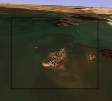
I confess it took me a long time to fidget with the controls to get that image to fit, but I was trying to make a point:-) Use the opacity slider to check the accuracy.
Geopositioning all photos is not really a scalable proposal — unless we all did one each, of course. Also, not all images lend themselves to this treatment — some are too close, others are of inconstant patterns such as drifting sandbanks.
Voila, yet another way Google Earth will quash your productivity — unless you can call it “research” for a blog post:-)
[Update 17:10 UTC: It just struck me that it would be very cool if there were to be a button in Google Earth that let you “paint” that photo from that perspective on top of the base layer, taking into account the height mesh (DEM) data and buildings, so that you could subsequently fly over it. I have no idea whether that would be a trivial feature to implement, but it is definitely where research projects are headed, and it would make for a great way to turn 2D images into 3D images. Google’s PhotoOverlay controls are obviously sufficient to accurately geoposition such a shot. Scalability remains the main problem, here, I think.]
Stone circle or just stoned? Swedish geodatabase to the rescue
Much as we’d love to find evidence of how astronomically savvy our ancestors were, sometimes a stone in the ground is just a stone in the ground. In Sweden this week, noted media hound and self-ascribed “archeoastronomer” Bob Lind announced to great media fanfare that he had found a 3,000-year old stone circle in Southern Sweden, complete with a “large phallus” pointing north.
Since a good false story reported uncritically is better than no story, much of the media went along, including the otherwise reliable The Local (tsk).
But then came the backlash of the experts. Martin Rundkvist, who writes the excellent Aardvarchaeology blog and who happens to be Swedish, led the charge. It turns out (Swedish) that the site is not new at all, but a stone-age cemetery that’s been known to archaeologists since the 1930s.
The one good thing to come out of this little media debacle is that it vindicates the pioneering work of Sweden’s Office of Antiquities when it comes to putting existing archaeological discoveries on the map. Their geographic database of historical monuments with KML output has been blogged on Ogle Earth before — for today’s story, I can use it to link to the precise location of the “find” that wasn’t: Ravlunda 169:1. From there, you can get KML, or else see it on Sweden’s two homegrown mapping sites, both of whom have the area in higher resolution than Google. (Eniro’s is the best).
Bob Lind could have checked that database to see if he wasn’t about to do something stupid, but that would have meant media obscurity. (For example, he could have looked at all the results for the local area, and then exported them to KML to see if the location of his “find” had a marker on it.)
Still, it’s good to know that the resource exists for real archaeologists.
EarthNC’s trip and route planner
I’ve just arrived in soggy Kuala Lumpur, tired and jet lagged after far too long in the purgatory that is Dubai airport. Tomorrow starts Global Knowledge Conference III, theme: Emerging People, Emerging Markets, Emerging Technologies. If I see any really cool new applications of GIS in the service of development, I will be sure to blog them. In the meantime, I am grateful to EarthNC for writing the rest of this post, so I can get some sleep:
EarthNC, Inc is pleased to announce the general availability of the EarthNC Google Earth Trip and Route Planner tool. The Trip and Route Planner provides a simple method to plan trips or routes using Google Earth and export them directly to Garmin USB GPS devices using the free Garmin Communicator plugin. For non-Garmin GPS devices, EarthNC provides a GPX file download option. With the release of the latest Garmin Communicator Plugin, the EarthNC Trip and Route Tool works on both Macintosh and Windows computers. [This is new!]
The EarthNC Trip and Route tool extends EarthNC’s novel ‘TakItWithMe’ Google Maps serviceto the 3D Google Earth platform. Trip planning and export is done with a few easy steps. To share trips, users can e-mail their trip folders to friends and family within Google Earth.
To help get users up and running quickly, EarthNC has produced a short video tutorial which demonstrates Google Earth trip and route creation, GPS export, and advanced tips:
The Trip and Route Tool is a free service of EarthNC.
(And if you’re still here, on a completely unrelated matter, also check out Google Maps API Blog’s Using the Chart API in KML for Quick Data Visualization.)
Links: Earth monitoring, neo geo who?, Flickr places explained, Syria censorship
- Earth monitoring: Nature has a special issue on Earth monitoring out. Nature reporter Declan Butler blogs it, and provides links to PDFs of some of the articles.
- How now, neo geo? In case you’ve missed it, over on All Points Blog a debate has erupted as to whether neogeography is GIS or not. One unintentionally funny comment:
This “neogeo” can provide acuraccy? [sic]
The guardians of the GIS gate are wondering whether neogeographers should be let in. The problem is that we barbarians are already inside the gate, and we’re charming the socks off the good burghers’ daughters. (Andrew Turner at High Earth Orbit has more.)
- Flickr Places: Flickr’s Dan Catt explains the rationale behind the new Flickr places pages over on Geobloggers. I hadn’t quite gotten the point of these pages before — it feels less dynamic than what went before, but Dann explains thus:
The “Places” project is one that’s been brewing for quite a while. My glib reason for having them, is actually to have a page from which we can hang location based geoRSS (and KML) feeds off. I mean we have geoRSS feeds for San Francisco and so on, but up to now no-where on the site that you can get to them from.
So expect KML (network?) links soon.
That said, I’m still wishing for something that was even more versatile — GeoRSS and KML feeds for pictures that are within a certain radius of a coordinate or within bounding boxes would be my choice. That way, you’d be able to collect images from odd places like Antarctic bases, a particular stretch of coast off Ireland, or just the three block area around where I live.
- Censored in Syria? So Facebook is blocked in Syria due to Israeli “infiltration”. Zeinobia on Arabicareport assumes the reason you can’t get Google Earth in Syria is for the same reason — Syrian government censorship — but in this particular case she’s wrong. It’s US export regulations that forbid Google from making Google Earth available in Syria (and Cuba and Sudan and no doubt North Korea, were anyone other than Dear Leader to have an internet connection).
- Nice maps: Digital Urban points to “possibly the best city map in the world”, on Edushi.com. Surely not scalable, unless you’ve got cheap labor, and lots of it. If this being the Chinese century means cuter maps, I’m all for it:-)
- Hyperwords: Also at the Berlin Online Educa, Hyperwords had a stand. They are the makers of a completely free Firefox plugin that lets you do an astonishing amount of contextual menu-based actions on the words on a web page — including mapping any location name to Google Maps.
- GPS cameras anyone? CNET on whether 2008 will be the year of GPS-enabled cameras. The reporter is skeptical — GPS units need to fix their positions more quickly before GPS can go mainstream. I’d agree. Apparently, improvements are in the works.
Photosynth competition: Microsoft’s Photosynth looks like it might be getting competition, according to Wired:
Researchers at the University of Washington have developed a piece of software that synthesizes thousands of photos, digitally edits out your kids cheesing for the camera, calculates where each photographer was standing when they took the shot. By comparing two photos taken from slightly different perspectives, the software applies principles of computer vision to figure out the distance to each point. The app then stitches the photos together to create a highly detailed 3-D model of the Statue of Liberty, the Grand Canyon, or any number of tourist destinations getting snapped by the minute.
See the comments.
- ArcGIS converter: Mapperz looks at ET Geowizards 9.7, which he calls “one of the best all-round third party extensions you can get for ArcGIS.” Lots of options for converting to and from KML.
- KML@OGC feedback wanted: You’ve got until January 3 to comment on the OGC’s draft KML 2.2 standard.
- Where 2.0: O’Reilly Radar on what to expect at next year’s Where 2.0.
- Photo map choice: Locr.com, which lets you upload and geotag photos (including from your mobile) boasts it is the only photo sharing site where you can choose your map: Microsoft’s, Yahoo’s or Google’s imagery.
Géoportail gets 3D buildings, but stays closed
![]() France’s Géoportail adds 3D buildings to its Skyline Globe-powered 3D web browsing tool, which it first introduced to Windows browsers in back July 2007 (after launching the 2D version in the summer of 2006).
France’s Géoportail adds 3D buildings to its Skyline Globe-powered 3D web browsing tool, which it first introduced to Windows browsers in back July 2007 (after launching the 2D version in the summer of 2006).
The announcement by Minister of Ecology Jean-Louis Borloo says, and I translate here,
With Géoportail, France has the first European portal for accessing geographic information in three dimensions. It shows off the unique knowledge of the [state GIS agency] IGN, which has always provided cutting edge public service.
As a result, most French blogs are reporting the news that Géoportail has just added 3D, when it has in fact had it since July. (The buildings are new — as are some new default layers, like walks and georeferenced archival news videos).
And while Géoportail is indeed the first portal made by Europeans for 3D mapping (albeit by licensing American technology), it is not the first portal to show Europe in 3D. In fact, it still doesn’t. (Google Earth, NASA World Wind and Microsoft Virtual Earth came before and do all of Europe. Géoportail shows nothing beyond France’s borders.)
Géoportail certainly is much more impressive that the UK Ordnance Survey’s “outreach” effort, but both are just as closed in a time when everything online is moving towards open, interoperable, mashable standards. KML is now an OGC standard, most recently embraced by Microsoft. Where is the support By IGN and OS? Why can’t I export anything to mash up? Where are the APIs? The USGS, on the other hand, gets it.
Time to reiterate: National GIS agencies should concentrate on getting the best GIS content, acting as a repository for it, and making it accessible to all. Competing with Google and Microsoft to provide end-user services based on this content is a waste of public resources, especially as Google and Microsoft will always do it better.
Karachi property dispute turns to Google Earth
A property development dispute in Karachi got some help from Google Earth this week. The article in Pakistan’s Daily Times is a thicket of acronyms, but if I understand right, a section of a park (one of a precious few in Karachi) is being developed by the town council for housing. The council claims such development was always intended, and that the infrastructure for it was laid in the 1990s, but petitioners have managed to show in court that the construction of sewage lines is recent (and visible in Google Earth). The judge has now adjourned the case for a few weeks so that the court can “summon residents to establish the facts.” (That’s a novel concept:-)
The Google Earth Community layer labels many of the places mentioned in the article. Here they are below. Included is an educated guess as to which construction imagery the court is talking about.