Ogling Earth, literally: There is a new thank you page (Mac, Windows) that you get to see when you download Google Earth, with new favorites. One of them links to the giant Maxim magazine cover (KML) in the desert near Nevada — a new breed of ad has well and truly arrived.
National Parks: Another link off the new download page leads to the Discovery Channel’s website, which is starting to publish layers for Google Earth that georeference its video library. Today, a video tour of US national parks. This press release promises more where that came from in the coming months, including HD video.
It’s all done very professionaly, but for a second I thought (and hoped) they were offering live video of bits of Earth, rather than georeferenced video. A live webcam of Times Square from the top of a skyscraper, or of hippos watering from an observation tower, as a live updating image overlay — now that would truly blow me away. I’m assuming that asking for the same from a geostationary satellite is still something only the CIA can afford, à la Syriana. (National Geographic was first to Earth with georeferenced video of Africa, and indeed has a default layer in Google Earth.)
Earthquakes: The USGS website on the 1906 San Francisco quake is now up. It is state of the art, and well worth the visit.
Most of the re-reporting around the web regarding Honda’s integration of its road congestion data with Google Earth assumes (Engadget certainly does) that Google Earth will find its way into the Honda Civic’s dashboard. That’s not actually what the original report states, based on this Japanese press release, translated into English. Just the facts, then:
Honda Civics in Japan can wirelessly upload telematics data to a central location as part of something called the InterNavi Floating Car System. This aggregated data is then used to determine road congestion in near real time, which is made available to the dashboards of drivers who are members of the “InterNavi Premium Club“, to help them choose the best route. The press release says this data is now also available (to members only) as a Google Earth network link from the Internavi Premium website.
That is certainly innovative in that it constitutes a whole new take on collaborative content for Google Earth, but it is empatically not about putting Google Earth into Civics. It’s about letting you play with the data in Google Earth. (You could of course run this network link off your laptop with Google Earth in your car if you have a 3G modem.)
In other words, Volkswagen has nothing to be worried about. (I wonder if the Volkswagen Google Earth dashboard will be able to load user-submitted network links and overlays. If so, it could theoretically upload Honda’s congestion data:-)
The USGS will later today release a virtual tour of the 1906 San Francisco earthquake that plays itself out on Google Earth. That’s not surprising, considering the media attention their Google Earth-based virtual helicopter ride over the Hayward Fault got last month. (Via Gary Price’s ResourceShelf)
Rev Dan Catt leaves some tantalising clues as to what he is working on at Yahoo! on this Flickr message board. It appears to be an API for points of interest and other georeferenced content, and it could be used by enterprising hackers to build a “geoblogger killer”, according to Dan. But read the clues in his own words. (Thanks Adam for the heads up).
Geography 2.0notes that there is now a plugin for NASA World Wind 1.3.4 that maps Microsoft Virtual Earth map tiles onto the surface of NASA’s world. (Back in September 2005, Rev. Dan Catt and Bernhard Sterzbach came out with network links that map Google Maps tiles onto Google Earth.)
TrailrunnerX, a delicious-looking Mac route planner for endurance sports, now has Google Earth support, in that it lets you export your trails as KML.
Another web design company starts marketing its Google Earth development services to mainstream companies: the UK’s Netizen, whose slogan is “Creating better travel websites,” now has a subsite dedicated to integrating travel sites with Google Earth.
Now that Macs run Windows, I can’t wait to run NASA World Wind, and ESRI ArcGIS explorer. In the not too distant future, then, expect Ogle Earth to expand its coverage to include these two geobrowsers.
Ogle Earth goes back to regularly scheduled blogging this evening.
Over on Google Earth Community, Mike points to a VBA macro application for AutoCAD Map 5 that
writes KML from AutoCAD, “with support for lines and polylines”. Examples are provided, but I can’t test this myself, obvs. If anyone tries it, feedback is welcome.
3pointD.comhas an interesting idea for mashing up Second Life with Google Earth to make the latter more collaborative when it comes to local information.
Grade school eachers, register for free to get access to TeachingHacks blog‘s Google Earth 101 online web resource. Here’s how. (Via IMYM Tutorials)
ArcDex [GIS2.0] blog posts a tutorial on how to convert ArcMap data to KML using the Export to KML ArcScript available at ESRI.com.
SKMap, a Skype-Google Maps mashup, now has more refined Google Earth support.
Now India’s ex-defence minister, George Fernandez, is being trotted out to slam Google Earth. Fernandez is a reknown nuclear hawk who presided over India’s nuclear tests while denying their existence back in 1998: About Google Earth, he says: “It is dangerous. There is a reason to worry. This will affect our national security. I will look into it and express my concerns to the government,” But what about Iran? ‘He said New Delhi need not be bothered about “what US thinks of Iran” as India was a “major political power”. “Iran has always been our friend. We should see to it that no harm comes to it,” he said.’ Riiiight. Google Earth is dangerous. Iran is not.
Google Earth patent infringement update: Skyline issues a press release noting that the trial date has been set in an expedited manner, and that this “usually a strong indication that the court views the claims of patent infringement as having real substance”.
Regardless of whether these conspiracy theorists are right or merely barking, you can’t fault their use of Google Earth to bring the downing of TWA FLight 800 in 1996 to life. Here is the KMZ file.
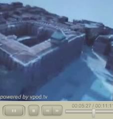
Today’s must-see destination for ardent followers of virtual globes is a blog post by a French technology consultant, Jean Michel Billaut, who has put up an 11-minute video of France’s upcoming GéoPortail in action, demonstrated to him by Patrick Leboeuf, the man behind the whole initiative at the Institut Géographique National (IGN).
Granted, the whole thing is in French, but in this case the images speak for themselves. Some highlights:
What is being shown is the 3D version, which looks like a dedicated Windows application with a similar layout to that of Google Earth. The 3D version will be out early 2007, whereas a 2D version will be out this summer.
The video shows off some impressive capabilities, albeit just for France and its territories. Resolution will be 50cm per pixel for all of France, and it works smoothly on the laptop used in the demo. Development looks to be far advanced, certainly at a Google-beta level.
The single-most impressive part is when Leboeuf shows off texture-mapping for 3D building facades, taken from real photographs (5:20). He says that they plan to have this operational for the city of Toulon, for starters.
In addition to aerial imagery, the video shows that there will also be topo maps and property maps (7:50) available, and 3D buildings (4:48), roads (4:30), all French postal addresses (7:10), and more. Some of these features will be pay services.
Leboeuf says that while IGN, being a French government agency, owns the data that GéoPortail renders, it is not the exclusive provider of these data (10:40) — Google Earth is free to purchase them, he says.
Overall, this demo of GéoPortail gives us a glimpse of some amazing new features that are just around the corner for geobrowsers, made all the more remarkable by the fact that it is the product of a government push to democratize access to the geospatial data that it possesses. (Via Innis)
Modulo Security, a “risk assessment, compliance and knowledge management company,” has introduced a “geo-referenced risk view” that uses Google Earth to map risk areas:
Created to allow control of risk in different business units, “Geo-referenced Risk View” produces a detailed map of the analysis area and defines the risk level for that area. Using Google Earth, users define the business unit to be analyzed and Check-up Tool maps all the assets and their corresponding risk levels, in full color and detail. This makes it possible to identify and classify risk levels in each unit, providing an overview of the risks involved with each asset. The map uses colors to identify the existing risks in each area.
Blogs have been slow to integrate with Google Earth, in part because creating a KML link is still more laborious than creating an HTML link. And yet there are certain classes of blogs that are just crying out for integration in Google Earth — for example, sailboat blogs, where the content of posts tends to be very location-dependent.
SailBlogs provides an ingenious solution to this technical challenge: It’s a blog hosting tool that automatically links such blogs to the sailboat’s current location via a Google Earth network link. With the link, you can see the positions of all participating sailboats; click on one to go to its blog.
This is what we need more of: Blog hosting tools where the integration with Google Earth is taken care of seamlessly. I wonder if future plans for Blogger include Google Earth integration — it’s an obvious synergy for two of Google’s acquisitions that is still waiting to be exploited. (Via Tim in Ogle Earth’s comments)
Notes on the political, social and scientific impact of networked digital maps and geospatial imagery, with a special focus on Google Earth.

 The single-most impressive part is when Leboeuf shows off texture-mapping for 3D building facades, taken from real photographs (5:20). He says that they plan to have this operational for the city of Toulon, for starters.