Category Archives: Uncategorized

Belgian military sees no danger from Google’s imagery

Belgeoblog has news (in Dutch) of the Belgian military’s stance on Google’s high resolution imagery. The verdict? Unlike the Dutch, the Belgians are “not afraid” that Google’s imagery might be useful to terrorists, according to the Belga press agency, citing military sources.

Transcribing more fully, then, from the original article posted on Belgeoblog:

The Belgian Ministry of Defence is not planning on censoring Google’s imagery, as the Dutch have done (blogged here and here), a spokesman has told Belga. The spokesman points out that in any case, such imagery has been available for years from commercial providers.

According to the article, Belgium’s defence experts further maintain that mere access to high-resolution images is not sufficient to glean anything useful from them. Image analysis is a specialty that takes advanced training, and requires combining information from images with other intelligence sources, they say.

Glad to hear it. Proud to be Belgian:-). Perhaps Google could reward such a positive attitude by giving Belgium some high-resolution love, say, around Antwerp?

Pin in the map

pitm.pngIn the mapping simplicity stakes, there is a new player: Pin in the map, a Google Maps API-based web app announced with a press release by UK developers Eden Development.

Pin in the map is nothing less (or more) than one-click placemarking, to which you can add text, a picture, an optional password for later editing, and then email the resulting unique URL to friends (example). I’m reviewing it on Ogle Earth because every URL, if appended by “/earth”, will also open in Google Earth.

The business plan: “Premium pins”, minus the Google ads and plus your business name in the URL.

How does it compare to contenders? Tagzania is far more powerful, offering tags and feeds, different map options and javascript to put readymade maps onto your own site, but you also need to set up an account first, and that may just be overkill if all you want to do is send somebody a link quickly. And Tagzania doesn’t let you make private placemarks, whereas Pin in the map does.

The latest iteration of Microsoft’s Virtual Earth offers something nearly as simple to use as Pin in the map, and its enhanced “collections” feature lets you group placemarks, which I can see even casual users wanting (Pub crawls, photo collections, house hunting candidates…). These collections can be private or public, too. As with Tagzania, however, you first need to log in before you can use Virtual Earth’s placemarking features. And there are no links to Google Earth in Virtual Earth, of course:-).

Pin in the map‘s unique feature, then, is that you need no account to use it, and this will speed adoption by casual users. Having in the past called Tagzania a “del.icio.us for places”, there is no escaping the obvious conclusion that Pin in the map is the TinyURL of places.

DIY phylogenetic trees in Google Earth

Roderic Page at Iphylo points to Bill Piel’s Experimental Google Earth Phylogenetic Tree Server, which lets scientists upload georeferenced phylogenetic trees as textfiles and then visualize them in Google Earth. (Definition of Phylogeny, tree map).

Here is a sample (ZIP). It shows views like this:

treemapfrog.jpg

That’s an awesome bit of automated visualization.

You may remember Guiology‘s work on tree maps using Google Earth, posted a few weeks ago, using the phylogeny of the H5N1 avian flu strain. Bill Piel’s work lets anybody visualize this kind of hierarchical data.

Iphylo’s Roderic has some very interesting ideas about what these geospatial tree maps can tell us, and it’s well worth reading. (His suggestion of using node height as a indicator of age was even anticipated by Andrew @ Guiology.) Roderic also suggests that panbiogeographers (definition) take to using Google Earth as a visualization tool.

Bill Piel asks that only taxonomic phylogenetic trees be uploaded to the server, presumably because the network link will show them. But his work could easily be adapted to visualize non-scientific tree maps that have a geospatial component — for example, distribution channels for businesses, or the diffusion of technological and cultural ideas.

Win a free pass to Where 2.0 with Ogle Earth

Where 2.0 is almost there, coming to San José, California, on June 13-14. It’s not too late to register, at $1,495 a pop, or you can try your luck with Ogle Earth: Where 2.0 Program Chair Nathan Torkington has kindly offered three free registrations to give away to Ogle Earth readers.

After thinking about it for a little while, I’ve decided that since this blog has a global readership, disbursing these three passes to the first three responses wouldn’t be fair, as at any given time fully one third of Ogle Earth readers are asleep:-)

So instead, for the next 8 hours, until 21.00 UTC May 26, 2006, please email one-off address ogle.where@gmail.com if you’re interested in a free pass and you can make it to San José in mid June. Please write a sentence telling me who you are in the body of the message. Duplicates will be disqualified. Anybody is eligible. I will then run a random number generator and choose the nth email, thrice. (I’ll be announcing the winners.)

What I really like about this competition is that it embodies everything I stand for: Leave everything until the last minute, maybe you’ll get lucky:-)

(Much as I’d love to go to Where 2.0, I can’t make it, unfortunately. I’m moving to Cambridge (UK) for the summer to work on a new web development project, and can’t really wander off to California for a week. I’ll be blogging Where 2.0 vicariously, however.)

Google/Dell deal: What about Google Earth?

Google and Dell have struck a deal to preinstall Google Desktop, Google Toolbar and a co-branded browser home page on new Dell computers aimed at personal and small busines use, as reported by the BBC and Reuters.

Quote from Google CEO Eric Schmidt, via Reuters:

“There’s probably more to come” in the Google-Dell partnership, Google chief executive Eric Schmidt told investors at a Goldman Sachs & Co. Internet conference. “This is the first” of several agreements.

Could Google Earth pre-installs be next? The entire Google Pack? Or would that be just too big of a bandwidth hit, even for Google? Or perhaps pay-per-install marketing is prohibitively expensive?

(Tangentially related: Dell’s Enterprise Command Centre in Malaysia uses Google Earth in an interesting way.)

(Pssst Google: Apple does preinstalls too. My MacBook Pro came with Comic Life and OmniOutliner, free.)

Mapping popularity contest, cont.

Last weekend, Hitwise’s global research general manager Bill Tancer hit upon the idea that search term popularity for mapping services might be a good proxy for mindshare. This follows a much remarked-on post of his on Friday where he looked at mapping site popularity from the perspective of “internet visits”, though that data was of US surfers only (something which was left unmentioned by most re-reporting — I originally assumed it was global data too, until I read Bill’s clarification in his comments). I blogged that post, and tried to leave some comments, but only the first one made it past moderation, so here goes with some more questions about the metrics:

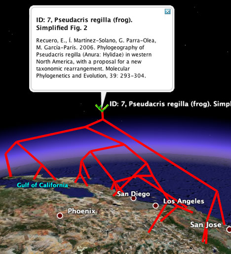
Hitwise gets its data via an ISP affiliate program, so that it has access to ISP customers’ web surfing logs. This info includes “a range of industry standard metrics relating to the viewing of websites including page requests, visits and average visit length,” according to this page about their methodology. I don’t see how such data can capture Google Earth usage, so I’m pretty sure that Google Earth’s 2% share of mapping site usage that Hitwise reports only refers to visits to the Google Earth website, where all you can do is download the application.

But this incongruity between new internet uses and old metrics also extends to AJAX-based services. Specifically, using the APIs of web services like Google Maps, Yahoo! Maps, Microsoft Live Local and MapQuest (free since March 2006) to make mashups on your own domain is not something the traditional accounting model for usage stats captures. Since Google Maps is the first and overwhelmingly popular choice for mashup makers, the Google logo has been in front of far more eyeballs than Hitwise’s numbers suggest.

Hitwise’s mindshare chart for these mapping services is interesting in another way: It allows us to compare Hitwise data to Google’s own. Notice how with Hitwise’s US data, Mapquest has a very large mind share, compared to others:
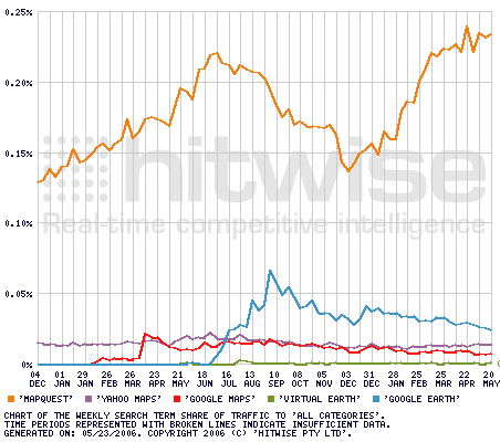
hitwise.png

(Source)

This correlates well with Google Trends’ own mindshare chart for US users:
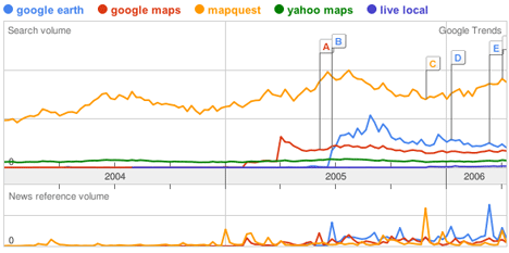
gt-us.png
Link

More relevant, however, is Google Trends’ global mindshare chart for maps, which I made a few weeks ago when Google Trends first came out. it shows Mapquest running neck-and-neck with Google Earth:
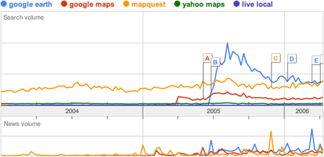
gtrendsm.gif
Link

What does this tell us? That MapQuest’s brand awareness is largely a US phenomenon — probably because MapQuest has traditionally been weak in non-US maps.

In addition, now that we know that Hitwise’s dataset is US-only, I suspect Google’s position in search vs. Yahoo! and MSN is even stronger globally, because Google’s localization efforts are far more advanced than the competition’s. Still, I think the overall global market share for the big three search engines is lower than Hitwise’s US numbers, simply because of the existence of local services, like China’s Baidu.