- MSNBC has a story about how one of the many proposals for
securing the Mexican borderhunting down illegal immigrants would involve Google Earth:
For Lockheed Martin Corp., blimps are a big part of the solution. And for Raytheon Co., the key is letting agents watch incidents unfold on Google Earth.
I for one hope Google doesn’t license its software for this purpose. Borders are arbitrary; people’s aspirations are not. If terror abatement is the goal, then a far better use of the money would be to secure US ports. Feel free to use Google Earth for that. Sorry about the rant.
- Forbes writes up “the mashup economy”, and of course Google Maps and Earth both feature. Unfortunately, they feature like this:
In a little over a year, more than 30,000 people have downloaded the code to invent software using Google’s maps. There is no saying how many have built big mashups from the downloads, leveraging the 100 million people that have used Google Earth, the map service from Google itself.
I really don’t mean to be nitpicky, but if you’re going to put in the details, then the details have to be right: The Google Maps API is not used to write KML for Google Earth. No, Google Earth is not Google Maps. One is round, the other is flat.
Category Archives: Uncategorized
Avian flu layers get time data
Declan Butler updates his avian flu layers to take advantage of the time browser. Here is his post, and here is the network link.
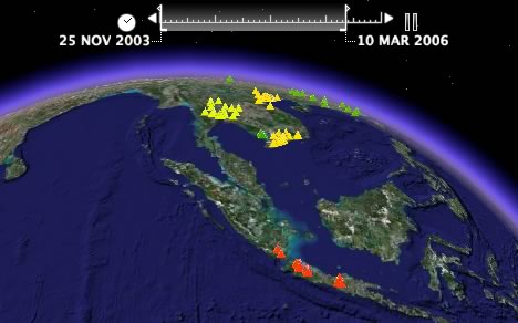
It’s immediately clear that this kind of data comes into its own when displayed along a timeline. The progress of the virus from Southeast Asia to Europe via Russia just jumps right out.
Short news: Time again, WMS bug reports, Picasa 2.5 out
- Because time in Google Earth is still new: Watch the rise of the Costco store across the US. (Via this LiveJournal post) The possibilities are mind-boggling:-)
- How to turn monthly Earth Observatory images available on the web into a time-enabled network link, by Valery Hronusov: 1) Using the EditGrid web-based spreadsheet, collect the URLs of the images in individual cells, one row for each year, one column for each month. 2) Build an XSL transformation that turns the XML version of the spreadsheet into KML. 3) When time arrives to Google Earth, just use the column and row values of the spreadsheet with XSL to create time tags in the KML. Voila, a network link that returns a playable time-lapse version of aerosol densities, snow cover, chlorophyll readings, what-have-you. Here’s Valery’s post to the Google Earth Community.
- Some of those who regularly play with WMS for their work are finding Google Earth’s WMS support a bit rudimentary. Chris’s Tweedle posts a list of possible improvements, and commenters add some more. Adam Schneider adds a bug report here. In my own short experience, I find it can be hard to tame the image a WMS server returns to match the topography on Google Earth below it.
- If you were wondering why Google Earth Plus and Pro’s KML output when importing GPS tracklogs looks identical to GPSBabel’s, that’s because Google Earth uses GPSBabel’s open-source code. (Thanks to Robert Lipe for the reminder.) This of course also means that you do not need to buy Google Earth Plus if all you want to do is use its GPS importing functionality — download and run GPSBabel instead. Both the Mac and PC version come with a GUI, or you can even use it as a web app, courtesy of GPSVisualizer.
- Given the previous bullet point, why not just make GPS importing available in the free version of Google Earth?
- Picasa 2.5, Google’s photo editing application for Windows that lets you georeference photos with Google Earth, is now available as a download (executable) for everyone, rather than just the beta group. (Via Documenting Picasa, which lists all the new features.)
- University of Arkansas students push SketchUp to the limit and get their own press release.
- France’s Le Monde runs a scathing article about recent French public sector attempts to launch web-based projects intended to compete with private companies such as Google. Exhibit A: Géoportail vs. Google Earth. The nut graf (translated):
The failures of Géoportail caused more scorn than previous attempts. The reason is simple: the inevitable comparison with Google Earth is cruel. Launched one year before, without an ounce of publicity, Moutain View’s software has not experienced the smallest failure. After Katrina, Google even continuously updated imagery of the affected zone while millions of visitors came to consult the data several times per day. Google then apologized for an access delay to the images of… two seconds.
The last bit about the two-second delay sounds apocryphal — I’ve certainly never heard of it. Google Earth has been down once or twice in Europe for a few hours, and that’s nothing to be ashamed of, but why let facts get in the way of a good argument?
- Over at InfoWorld, Jon Udell fantasizes about a Google Earth-like HUD for airline travellers. As he suspects, something like that is possible now: Get Google Earth, a flight that features Connexion in-flight wifi (while it lasts), a GPS unit, a window seat, a live tracker like gps2geX for the Mac or Getrax for PC, and finally lots of semantically rich KML content like Wikipedia, nearby Flickr photos, FBOweb’s nearby flights. Plug it all in, and presto.
Time machine roundup: GPSVisualizer, GPSBabel, KMLer, Arc2Earth
Within days of Google adding a timeline to its Earth, four of the most impressive KML creation tools all have time tag support:
- GPSVisualizer, Adam Schneider’s free but crazily feature-rich web-based converter of GPS data to KML (and much more besides), has added the option to “Add time stamps, if possible” to the upload form.
- GPSBabel 1.3.1, an open source application for PC, Mac and Linux that takes GPS data and converts it to KML (and many other formats), “should build these tags for you automatically on download”, according to project lead Robert Lipe.
- KMLer 1.4, Valery Hronusov’s ArcGIS 9 extension that gives you all kinds of options for exporting to KML (and importing from KML), can now also create <TimeSpan>,<TimeStamp> and <When> tags from ArcGIS layer attributes. Cost: $20-$50, depending on the version. There’s a free 7-day trial.
- Arc2Earth, Brian Flood and his team’s ArcGIS 9 extension for exporting to (and importing from) KML, now has a comprehensive new time data tab that lets you fine-tune your time-enabled KML. Brian has posted a walkthrough of the functionality, including some examples, such as US states, time-stamped by date of accession. Cost: $100-$300, depending on the version. There’s a free 30-day trial.
Have I missed any? (It goes without saying that Google Earth Plus and Pro’s GPS importer also produce time stamps.)
Quick bugfix: Google Earth 4.0.209x beta now available
Those early bug reports about external controllers in the PC version and the broken time functionality in the Mac version? Fixed! You can now download version 4.0.2091 beta for PC and version 4.0.2093 beta for the Mac. (Sorry, can’t verify Linux.) Here’s the delta report:
- External controller now has a disable and is off by default
- Problem with Mac time animation fixed
- A few Mac Japanese translations restored
- Linux version now updated
- Faster network performance for non-US users
So, at your leisure, go get an updated copy.
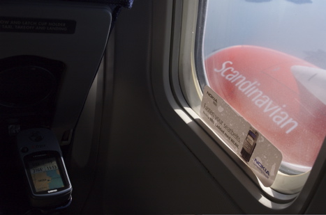
Tracklog to timeline with KML’s <TimeStamp>
I wanted to try the new timeline functionality in Google Earth, so fortunately I had a tracklog lying around of a SAS flight I took between Brussels and Stockholm recently:
I massaged the data into KML (using grep in BBEdit), borrowing graphics from the whale shark example, to produce this KMZ file [Update: Fixed!]:
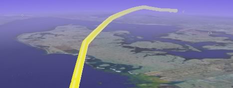
It’s a rudimentary first step, but it does work, as long as you’re not using the Mac version of the beta:-) (where a bug prevents time-tagged placemarks from showing up as intended.)
Short news: KMLer does time; FOSS4G2006 will do time
- That was fast: Valery Hronusov’s KMLer, an ArcGIS extension for converting to and from KML, adds support for KML’s time tags in the latest version, 1.4. It also covers other KML 2.1 innovations.
- For those of you who want a blow-by-blow account of Michael Jones’s keynote at eMerce eDay in Amsterdam two days ago, coolz0r is happy to oblige.
- Mikel Maron is back from the DR, just in time for a talk on time in GIS at FOSS4G2006 — and he’ll now have a client to do demos with: Google Earth. In fact, he already has a sample file up, posted to his blog.
- All Points Blog notes GeoRSS hits the 1.0 milestone. Happy Birthday.