- What a great resource: A KML choropleth map (I can pretend I knew what that is, but in fact I had to look it up) of Flickr photos as a network link. Click on a square and it takes you straight to the relevant Flickr map. Now you can have your Flickr photos and Google Earth too. How did this manage to live in the wilderness without bloglove for over two whole weeks? (Via The Map Room)
- It’s good to have validation of Google Earth’s Greenland imagery every so often. (Via The Other Here)
- Geocoding database Geonames gets a JAVA API. It’s open source, and on SourceForge. (Via Geospatial Semantic Weblog)
- TYRE Lets you copy waypoints from Google Earth to your TomTom.
- EPoint2GE converts coordinate data in Excel into KML using VBA. (For PC)
- Ashley Joyce’s Google Earth animator promises to “dynamically update a 3D model loaded inside Google Earth by using Google Earth Network Link capabilities.” This tool looks like it will be very useful for positioning 3D content just the way you want it. Check out the screenshots in anticipation of the beta.
- Now you can play Doctor No on the cheap. According to this press release:
Guardian Solutions today announced and demonstrated the first totally geo-spatial video surveillance system called GView(TM). It incorporates patent-pending technology that upgrades a facility’s digital video recording (DVR) surveillance system to a 3D situation awareness system for rapid threat detection and understanding. As the DVR records video events, GView(TM) isolates and tracks threats (individual, vehicle, vessel …) and displays, through Google Earth(TM), all movements on a 3D site model for a bird’s eye view of all “at risk” assets and video and non-video sensors.
Category Archives: Uncategorized
Google Earth for Mac + AppleScript = Geotagger! (and more!)
Mac users suddenly have plenty to rejoice about. What happened?
 Craig Stanton — he of iPhotoToGoogleEarth fame — just discovered that Google Earth 4 has a basic AppleScript library!
This opens up all sorts of possibilities. For Craig, it allowed him to build what is perhaps the simplest, most intuitive georeferencing application on any platform: Geotagger.
How does it work?
- Position Google Earth over the spot where you took a photo. (Need some crosshairs?)
- In your finder, drag the photo to the Geotagger droplet.
Done. Geotagger uses AppleScript to read the position of the center of the screen in Google Earth, and adds this to the EXIF metadata of the photo(s) you dropped on it. You can now import these photos into Flickr or Panoramio, where they will be automatically geotagged. If you import these photos into iPhoto, you can use Craig’s iPhotoToGoogleEarth plugin to export them as KML. Only caveat: The photos need to be JPEGs.
Being able to commandeer Google Earth via AppleScript really opens up a Pandora’s box for Mac users. Check out the commands:
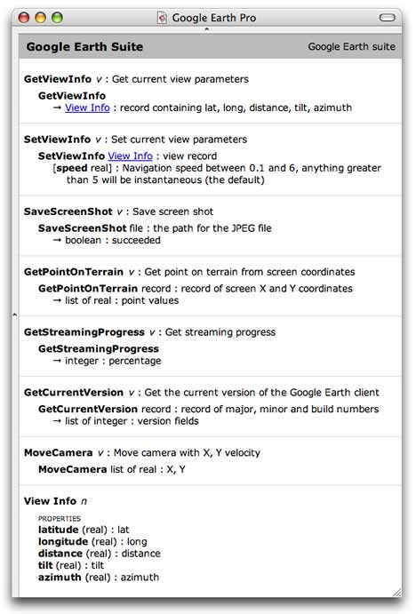
I had hopes for AppleScript support when GE3 came out for the Mac because I really wanted to build a remote control for Google Earth using my Bluetooth enabled mobile phone and fellow Stockholmer Jonas Salling’s Salling Clicker. Now that’s possible. Here’s the proof, taken outside on Stockholm’s Odenplan last night:
(Geeknotes: The mobile phone in the video is acting as the Mac’s 3G modem via Bluetooth while also simultaneously relaying commands via Bluetooth using Salling Clicker. No, that’s not why it crashed — the current Google Earth 4 Mac beta is a tad unstable if you as much as breathe on the preferences file.)
If you have Salling Clicker, you can download the file containing my (very simple) AppleScript commands for Google Earth. Treat it as a proof of concept; you’ll have to attach the scripts to phone keys yourself. I’m sure AppleScript gurus have ways of turning this into a more polished product.
I can’t wait for increased AppleScript support by Google Earth in the future. Imagine geocoding placenames via AppleScript, or taking screenshots of your house as wallpaper for your mobile phone, or letting GPS devices and location-aware mobile phones show you where you are in Google Earth. In fact, some of these things should even be possible with the current AppleScript library. Apple users, your Google Earth API has arrived.
Jelbert GeoTagger records camera heading data
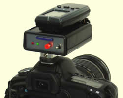 The Jelbert GeoTagger connects to a Garmin Geko 301 GPS device and fits into a DSLR’s flash shoe. Every time you take a photo the camera triggers the geotagger, which records the precise position and heading of a camera using the GPS device. Later you will add the Geotagger’s stored GPS data to the photo’s EXIF data via an application like RoboGeo (PC) or GPSPhotoLinker (Mac). (The Jelbert Geotagger is £149, the Geko 301 is $246.)
It’s a step forward for georeferencing photos vs. the traditional method of a calculating time-weighted averages of the nearest tracklog points. The holy grail, however, is recording a photo’s position data as EXIF the moment it is taken. Nikon has a cable that lets you do this for the D2X and D200 — the MC-35 ($99), which connects to your GPS device. Or make your own for the D200.
It doesn’t appear like the Nikon-specific solutions can transfer compass data, though, even if you were to use a Geko 301, which has an electronic compass built in. To do that, you still need the Jelbert Geotagger. Here is their demo of how the direction data plays in Google Earth. Good to see directional icons in use!
What else is left to innovate? Vertical tilt. My Nikon can already sense whether the camera is taking a portrait or a panorama shot, so this feature can’t be too far off. When all that is in place, there is no reason why the KML can’t be made to construct <LookAt> tags mimicking the view of the camera, as Alan Glennon mooted back in January.
(Via Hack a day, Slashdot)
Time-enabled Norwegian weather forecasts
What a difference high production values can make to a weather map in Google Earth. Trond Michelsen of the Norwegian Meteorogical Institute has turned NMI’s forecasts into a remarkable network link. It comes with cute-as-a-button icons, color-coded temperatures (which I really like — check northern Norway) and — the pièce de resistance — it’s all time-enabled. Icons change from suns during the day to moons at night, you can click them for more local info, and if you turn on the preciptiation overlays, you’ll see that cloud layers there match the icons. It just looks so professional. Almost makes one want to live in Norway:-)
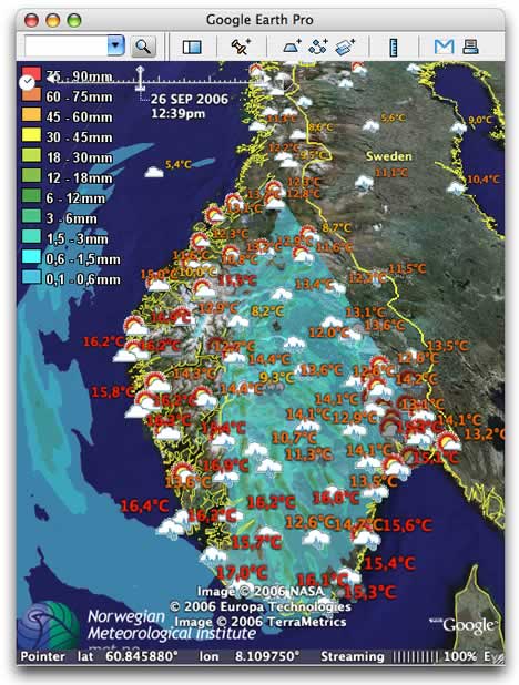
Trond wrote in with some of the technical details, below the fold.
Google Earth features in Saturn video ads
As suspected, Google Earth merely features as video footage inside the new Google Video ads for the Saturn car make, but it’s actually cleverly done. Google Earth in effect becomes a cheap special effects machine for the video ads, making it easy to churn out 22 different ads featuring different Saturn dealers, and then showing the one for the dealer nearest to the user, as determined by the IP address. That’s definitely something new.
Hashem Bajwa of Goodby, Silverstein & Partners, the ad agency that created the ads, wrote in with more info, below the fold.
Short news: Drupal, Blojsom, Katrina + time
- Hot on the heels of a KML module for the Drupal content management system, Dan Karran has now released a GeoRSS module. End result: You can suck in GeoRSS feeds into Drupal and show them as KML. (Via GeoRSS blog)
- Now that time is supported in Google Earth, Adam Burt has added time stamp data to the Blojsom CMS template he uses to output his blog as KML. Here’s a screencast of how it works. (Via Bedeviled Mojo Slop)
- Brian Flood demonstrates how the timeline works with overlays of Hurricane Katrina, and promises much tighter integration with ArcGIS coming up. Gorgeous.
- Valery Hronusov updates his existing bird migration data to take advantage of the timeline, putting the whole thing into EditGrid in the process.
- Digitally Distributed Environments is exploring ways to use SketchUp to rapidly apply photographic textures to sides of buildings.
- Google is helping Saturn to advertise their cars via the web in several US test markets, and apparently it involves Google Earth, reports the New York Times. It’s not clear how, but to me it sounds like they’re merely showing Google Earth footage inside a Flash banner ad. And that’s not anything to get excited about. (
DIY high-altitude ballooning
 Genius! Not a mile from where I worked this summer, Cambridge University students earlier this month launched Nova 1, a meteorogical balloon juryrigged with a digital camera, GPS, mobile phone and radio transmitter. The thing went 32 km straight up and took 857 photos at 15-second intervals, some of which show some clear curves. it returned to Earth via parachute, landing 45 km due East a little under three hours later.
They’ve turned the positioning data into KML, though their link is a bit iffy. Here is a proper network link for it. The result looks like this:
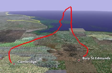
What I’d really love to see is a time-enabled path with screen overlays for all 857 photos. It’d be trivial to do. I can’t wait for Nova 2.