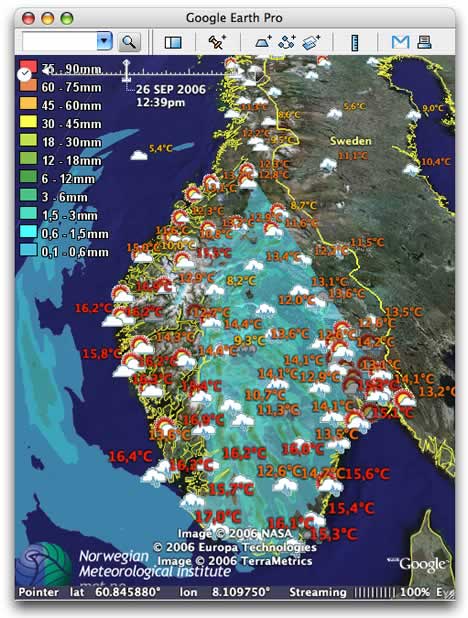
What a difference high production values can make to a weather map in Google Earth. Trond Michelsen of the Norwegian Meteorogical Institute has turned NMI’s forecasts into a remarkable network link. It comes with cute-as-a-button icons, color-coded temperatures (which I really like — check northern Norway) and — the pièce de resistance — it’s all time-enabled. Icons change from suns during the day to moons at night, you can click them for more local info, and if you turn on the preciptiation overlays, you’ll see that cloud layers there match the icons. It just looks so professional. Almost makes one want to live in Norway:-)
Trond wrote in with some of the technical details, below the fold.
[Trond writes:]
These are forecasts from the Norwegian Meteorological Institute, and they make use of GEs new time functionality. As you’ve noticed, GEs time support still leaves a lot to be desired, but I think it works fairly well in this example. I had to cheat a bit though, and say that the forecast for 6AM UTC is valid from 6AM to 12PM, and that the 12PM forecast is valid to 6PM, and so forth. It’s not accurate, but it “works”.
The kml-file is here:
It’s in Norwegian, though, so I’ve made a quick translation here:
Anyway – there are layers for weather symbols, precipitation measurements and four different weather models (temperature, precipitation, mean sea level pressure and wind).
For the weather symbols, I’ve used different colors for the label, depending on the temperature. On precipitation measurements, I’ve done the same, but here I’m also changing the scale of the label depending on the amount of precipitation. If it’s 0.0mm, the label is removed.
This is only a test for now, but if people like it (and I can’t really imagine why they wouldn’t :) we’ll probably make more weather models available in Google Earth.