John E. Bailey has just posted the schedule for the sessions on Virtual Globes at the 2006 Fall Meeting of the American Geophysical Union in San Francisco on 11-15 December, 2006.
[Hint: Click on the title or image of each session component to get a more detailed abstract.]
Lots of good stuff is listed, including a number of fascinating-sounding projects that have yet to be released publicly — they certainly haven’t been blogged here. Google Earth dominates the category, NASA World Wind has a good showing, and EarthSLOT makes an appearance. Conspicuous by its absence are demos of ESRI ArcGIS Explorer. Is it not a virtual globe? Shouldn’t it be ready by December?
If you’re making a presentation and have slides, links, KML or a website you’d like to show off beforehand or to the people who can’t make it (sigh) do send it along to stefan.geens@gmail.com, and I’ll gladly write it up on Ogle Earth.
Geonames.org gets some feedback on its adherence to semantic web standards, and in the process is noticed (and lauded) by some big names — as in Tim Berners-Lee big!
You may already have seen or used the mouseover effect for icons at points in KML. Now Jason Birch writes a how-to for extending that effect to an entire region, using the MultiGeometry tag.
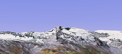
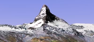
The Google Earth 4 Matterhorn demo also shows off the ability to convert terrain into 3D geometry for display. Here, a small patch of 30m DEM data is inserted into the Google Earth environment to demonstrate the lack of detail in the base terrain model. The draped imagery is 30m Landsat, natural-color processed with AlphaPixel’s PixelSense. Since no higher-resolution imagery was available the permitted free redistribution, VNS’s Snow, texturing and fractal subdivision features were used to improve the look of the relatively-coarse imagery and introduce more apparent detail and variation. This project was done in response to Ogle Earth demonstrating the poor resolution of GE’s basic terrain.
Chris got the Matterhorn’s detailed elevation data from Jonathan de Ferranti’s page containing tons of freely downloadable data for many mountain ranges — a real treasure trove. Jonathan even voices an appeal I can only second:
If these files were imported into Google Earth or NASA World Wind, there would be a spectacular improvement in results. If anyone finds some way of doing this, or better still, persuading Google, NASA, Terraserver or ESRI to do this themselves, then please tell me!
As Boing Boingreported yesterday, and the Guardianconfirms today, the Iranian government has instructed ISPs to limit the bandwidth of internet accounts to 128kbps. The aim: To curb a western “cultural invasion”. Yesterday’s decree follows a crackdown on satellite antennas over the past month.
You have to give those hardliners points for trying. Anything that is bandwidth intensive will now be spectacularly frustrating to do — including using Google Earth.
But if the conservatives’ intention is that Iranians will now merely stop downloading music, movies or imagery, then they’ve got something else coming. Throttling access to the internet by decree is, well, cultural waterboarding. It makes its victims very very angry. And as the Guardian reports, all the signs are that this latest decree is incredibly unpopular.
This post is a no-brainer. John J. Gardiner, a technical writer at Google and the author of the Google Earth user guide, has just launched a new blog (as one does): Using Google Earth. John writes:
The idea is to describe features of Google Earth that might otherwise be unknown to many users. Initially, I will focus on serving less experienced users, but I will discuss more advanced topics soon. I will also post some original KML content for folks to explore. Let me know if there are topics you would like to see addressed on this new blog. Thanks!
Which reminds me: I really need to update my link list.
Navideo is software for GPS enabled PocketPC that claims to perform some nifty tricks. You can track other Navideo users in real time, be tracked in turn, or send your position to others via sms/email. Navideo Controller for PC can keep track of multiple clients (using Google Earth), and send them new destinations. I’m sure it’s intended for car fleets, but just think of the real-life games you could build on top of this system…:-) (Via coolsmartphone)
Simplified Building Concepts is starting up a free SketchUp Library specializing in components and objects to place inside larger projects. You can also upload your own content. It’s in beta, but it looks good.
Valery Hronusov takes Geology professor Ron Blakey’s renditions of global plate tectonics stretching back 600 million years and wraps them around Google Earth, adding time stamps. His task is made much easier by using EditGrid thus. If you’re wondering whether Google Earth’s timeline supports events 600 million years ago, the answer is No. Valery had to cheat:-).
But one serious question: Is it really at all possible to know where mountain ranges were on these continents half a billion years ago, or are those drawn with a huge dollop of paleopoetic license?
After reading about the Italian man’s good luck, Madry got out his laptop, fired up Google Earth and looked over lands in Burgundy near his research area. Google Earth displays that area in particularly good resolution. Immediately he spotted features that, to his trained eye, resembled outlines of Iron Age, Bronze Age, ancient Roman and medieval residences, forts, roads and monuments.
“I’ve spent 25 years in this region of France,” Madry said. “In the whole time, I’ve found a handful of archaeological sites. I found more in the first five, six, seven hours than I’ve found in years of traditional field surveys and aerial archaeology.”
One quarter of them proved to be new finds. But the best news is here:
When [Madry] reported preliminary findings at the international Computer Applications and Quantitative Methods in Archaeology conference this spring, other researchers took notice. Those who work in countries where aerial photographs are forbidden or restricted for security reasons are particularly curious. Madry was encouraged to teach the technique at next spring’s gathering.
(With profound apologies for the title of this post.)
Notes on the political, social and scientific impact of networked digital maps and geospatial imagery, with a special focus on Google Earth.