Category Archives: Content

Starbucks’ global center of gravity

Jim Cser from Portland writes:

To follow up on your earlier Starbucks post, I got inspired and created a KML file of (almost) all the Starbucks in the world, based on data from their website. It only has the ones they map, which excludes most of Asia, but it’s still around 9,000.

He’s posted the KML file online. I obviously had to complete the circle and run Jim’s file through the center of gravity calculator. Without further ado, here is the world’s “densest” spot for Starbucks shops:

SBCoG.jpg

Perhaps unexpectedly, it’s on farmland in Northern Nebraska, 40km South of the nearest Starbucks in Yankton, South Dakota.

Given the “weight” of the 9,000 Starbucks that are mapped, the true center of gravity is unlikely to wander far from this spot if a couple of Asian stores were to be added. The precise spot is here in Tagzania.

Google Earth roundup for Wednesday

> Following London’s lead, it seems Paris might be getting its own Google Earth master builder: On Google Earth Hacks, an anonymous upload of a meticulouly styled Parisian apartment building, annotated with the vaguely mysterious “We are breaking new ground with GE, data rendering not seen before. Developed own technology and programming.” [Update 2006-02-13: The company behind this is a french outfit, Trimensions.]

last-tango.jpg

> Microstation, Bentley’s rather posh-looking CAD system for infrastructure design, is getting ready to come out with converters to KML. They’ve posted some examples, (the 3D Sydney Opera House (KMZ) is impressive) and are looking for beta testers. Details here.

sydney_op.jpg

> Google Earth wins the 2005 Engadget readers’ choice award for Best GPS device or Application. And made it look easy.

Press roundup

> The rooftop ad meme percolates over to Wired, whose Joanna Glasner writes up Roofshout.com and gets this awesome quote out of it:

“I’m currently launching RoofShout.com with no money, no real experience running a business on the internet, and no real solid business plan,” Fitz-Gerald said. “But I figure there’s a lot of blank roofs and a lot of advertising that could go on the roofs.”

The article also mentions RoofAds, which has been around for a while selling ads for aerial viewing around airports, but which has of late become aware of its expanding horizons. So to speak:-). (Via BNET)

> Forbes is down on Google, but gives Google’s mapping efforts a B+, the best score after search. (Points lost for slow monetization.) Via Inside Google, which has the Cliff’s Notes version of the article.

> Over on GISCafĂ©, Susan Smith reviews all the alternatives to Google Earth, incuding some I’d never heard of before. ViewTec‘s “Terrain View-Globe”? Leica’s “Virtual Explorer“? (Via the Institute for Analytic Journalism)

Monday morning shorts

Volkswagen’s Electronics Research Lab has released some visualizations to go with last week’s press release, as grabbed from Autoblog:

Figure-11_lr.jpg

There’s more where that came from. Jos at Jos’Blog looks at these and wonders what’s taking airlines so long to revamp their inflight entertainment system.

GoogleEarthing has started a mammoth new contest. If you have way too much time on your hands, you won’t want to miss this.

James Fee points the way to a short PDF that illustrates the ease with which ArcGIS Server 9.2 will be able to serve KML network links. Just as with WMS, you tick a checkbox, and voila.

Apparently, boaters tend to use the Nobeltec Visual Navigation Suite for electronic navigation, which lets you track your routes. Roly_in_Victoria_BC writes on Google Earth Community that he’s created a VB6 script that translates those to KML. If anyone is interested, he’ll release it, he writes.

Short takes for the weekend

Cnet’s Google Blog links to a British DJ’s music video that’s 95% Google Earth. It’s… watchable, actually.

brunei.jpg

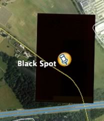
Google Blogspot gets mail that alleges Google Earth censored the Sultan of Brunei’s walled London mansion, and wonders how much he paid. I found the story unlikely, so went looking, only to find… A giant black slab partially obscuring his property on Windmill Lane. That is rather a lucky coincidence, don’t you think? Google Maps is no help. If the Sultan paid for his privacy, though, he will have paid The GeoInformation Group, which licensed the images to Google. Geo-Web talks about the upcoming GeoRSS open standard, which aims to let you use open format Geography Markup Language (GML) in a news feed, for example to describe a sailing race in real time. Mikel Maron at Brain off does his bit, writing an extension that parses GeoRSS in Google Maps called MGeoRSS. He hopes the big players get on board. (You can convert GML to KML, sort of.) Gizmos Grabowski has an interesting post about why the 49th Parallel does not line up with Google Earth’s US/Canadian border. (No, it’s not Google’s fault.) Pigeons will soon “blog” air pollution in San Jose, California. Who will build the tracker for Google Earth? (Via Smartmobs) James Fee of Spatially Adjusted writes a FAQ of sorts about ESRI’s ArcGIS Explorer closed beta. Among other things, he writes:

5. What kind of imagery will be provided by default?

This is a harder question to answer. Every demo that ESRI has shown to the public has only had 15m resolution. I don’t know if they have any plans to increase this, but since ESRI isn’t a data provider I suspect not. You can of course use any WMS service such as the Terraserver to fill in gaps, but I don’t think there will ever be as much or as high quality imagery as Google Earth has.

Finally somebody makes a 3D movie from Google Earth. Google Earth Blog highlights one made by Swede Jan Melin. Jan has also made a “time-lapse” movie where he alters the elevation multiple of mountains over time, here.

A major phonetapping scandal is roiling Greece. One blogger does some conspiracy theorizing using Google Earth.

NASA’s EAARL post-Katrina images in Google Earth

norleans.jpg
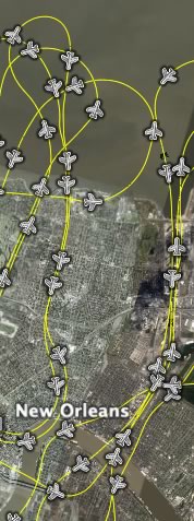
NASA writes up an impressive set of post-Katrina and Rita imagery that it published to Google Earth and which is completely new to me. There is a NASA news Story out today, as well as a feature story, detailed PDF instruction slides (and they’re intricate) and finally, the website of EAARL (Experimental Advanced Airborne Research LiDAR) where the new data sets are collected. (Direct link to download page)

What I find innovative about these sets of data is the manner in which they are made available to the user. The network link you download shows an actual flight path, along which little plane icons represent a minute of flight each. Click on an icon, and you get links to high resolution overlays showing how the coast changed as a result of the hurricanes. You can even drill down to a specific second of flight and overlay the image it took then. That way, you get access to vast amounts of data but only download what you need.

(These overlays seem to have had a soft launch on Google Earth Community back in December, but nobody noticed?)

An Earth for Google Talk

If you use Google Talk (or Jabber) and are social by nature, Talk Maps lets you advertise your status and location on Google Maps. it’s based on a clever hack: You add a bot to your friends list, so that it knows when you are available, and you also enter your coordinates on a special form once. Bingo, yet another way to meet new people from all over the world.

The reason it’s mentioned here, of course, is that Talk Maps now also boasts Google Earth integration. It’s a smart use of technology, but my inner misantrope wishes this could be restricted to just my friends. Perhaps have Google Earth fly to wherever a friend comes online, for example, if it’s not busy. Such integration between Google Talk and Earth is definitely one way in which Google Pack could be made to look more like a pack and less like a collection.