 NASA writes up an impressive set of post-Katrina and Rita imagery that it published to Google Earth and which is completely new to me. There is a NASA news Story out today, as well as a feature story, detailed PDF instruction slides (and they’re intricate) and finally, the website of EAARL (Experimental Advanced Airborne Research LiDAR) where the new data sets are collected. (Direct link to download page)
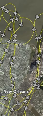
What I find innovative about these sets of data is the manner in which they are made available to the user. The network link you download shows an actual flight path, along which little plane icons represent a minute of flight each. Click on an icon, and you get links to high resolution overlays showing how the coast changed as a result of the hurricanes. You can even drill down to a specific second of flight and overlay the image it took then. That way, you get access to vast amounts of data but only download what you need.
(These overlays seem to have had a soft launch on Google Earth Community back in December, but nobody noticed?)