All posts by Stefan Geens

Finding Osama Bin Laden’s Abbottabad mansion with Google Earth

UPDATE: Scroll to the end of the article to see the final confirmed location of the compound.

UPDATE 2: A new post: 2011 DigitalGlobe imagery of Bin Laden compound, now on Google Earth

UPDATE 3: More posts: GeoEye publishes post-raid satellite image of Bin Laden compound, In the Situation Room, aerial imagery of the Bin Laden compound.

Osama Bin Laden’s death first manifested itself as short news items on Pakistani news sites: “Copter crashes on Kakul road – Monitoring Desk“, and indeed, later we would hear that one of the helicopters used in the raid on Bin Laden’s compound was damaged and destroyed.

The repercussions of Bin Laden’s death are still uncertain, but this post will just concern itself with the location of this compound. Where exactly was it? Can we find it on Google Earth?

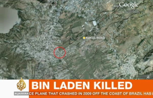
Al Jazeera English mentions “a mansion” surrounded by high walls, comprised of “boxes” with no windows. On a map of Abbottabad shown on their screen, Al Jazeera shows Kakul Road, and marks a specific location on that road, at the edge of some fields.

In a news story sourced to CBS/Associated Press, we get an eyewitness to tell us the following:

“I heard a thundering sound, followed by heavy firing. Then firing suddenly stopped. Then more thundering, then a big blast,” he said. “In the morning when we went out to see what happened, some helicopter wreckage was lying in an open field.”

He said the house was 100 yards away from the gate of the academy.

The New York Times reports that the mansion was “on the outskirts of the town’s center, set on an imposing hilltop and ringed by 12-foot-high concrete walls topped with barbed wire.” It goes on:

The property was valued at $1 million, but it had neither a telephone nor an Internet connection. Its residents were so concerned about security that they burned their trash rather putting it on the street for collection like their neighbors.

American officials believed that the compound, built in 2005, was designed for the specific purpose of hiding Bin Laden.

Is it possible to correlate these disparate clues? Not really. The NYT is most likely to be wrong as to the location — Al Jazeera footage shows a backdrop of flat fields near the compound, not a hilltop. Also, from the position marked by Al Jazeera on the map, the front gate of the military academy is around 2km away along the straight Kakul road, rather than the “100 meters” mentioned by the AP eyewitness.

I am inclined to give Al Jazeera the benefit of the doubt on this. They are the most likely to have people on the ground with the correct information, they are specific in their pinpointing of the location and their video footage supports their map.

But there is one further clue we can use. Google Earth’s high-resolution map of the area has imagery from June 15, 2005 — almost 6 years old. One set of older imagery is available — from March 23, 2001. If the NYT sources are correct on Bin Laden’s mansion being under construction in 2005 (and on this they are likely to be correct, as it sounds like a piece of information from an intelligence source) then we should be able to compare the 2001 imagery with the 2005 imagery, and look for any mansion-sized construction going on in 2005.

[Update May 3: Google today updated its base image layer to include imagery from Abbottabad taken on May 9, 2010 — just under a year ago. You can still see the imagery from 2005 (and 2001) by using the historical imagery time slider tool in Google Earth.]

And Indeed, in the specific region marked by Al Jazeera, there is construction underway in 2005. Below is the imagery in 2005, then in 2001, then in 2005 again with the construction marked.
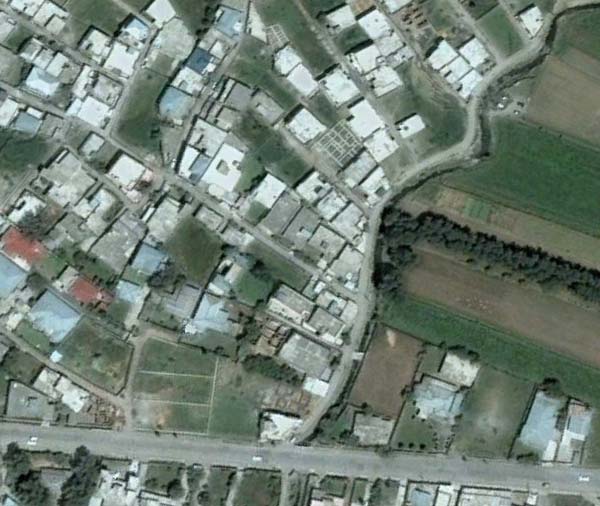

Imagery taken on June 15, 2005
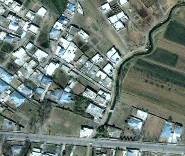

Imagery taken on March 23, 2001
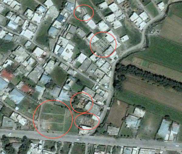

Construction ongoing on June 15, 2005

Of course, it is possible that construction on the mansion began after June 15, 2005.

Finally, here is a Google Map I’ve made of the locations mentioned in this article:


View Osama Bin Laden’s mansion location.kmz in a larger map

And here it is as a downloadable KML file for Google Earth.

It’s possible that these locations are wrong. The easiest way to find the precise place would be to walk on over there and take a look, but failing that, I will keep this article updated with more accurate information as it becomes available.

UPDATE 9:53 UTC: Pakistan-based journalist Omar Waraich tweets that the location of the mansion, and where he is headed to, is Bilal colony/town in Abbottabad. On Google Maps there is a marker tagged “Bilal Mosque” which corresponds perfectly with the screenshots of Google Earth above. In other words, there is reason to be more confident that the above locations are correct.

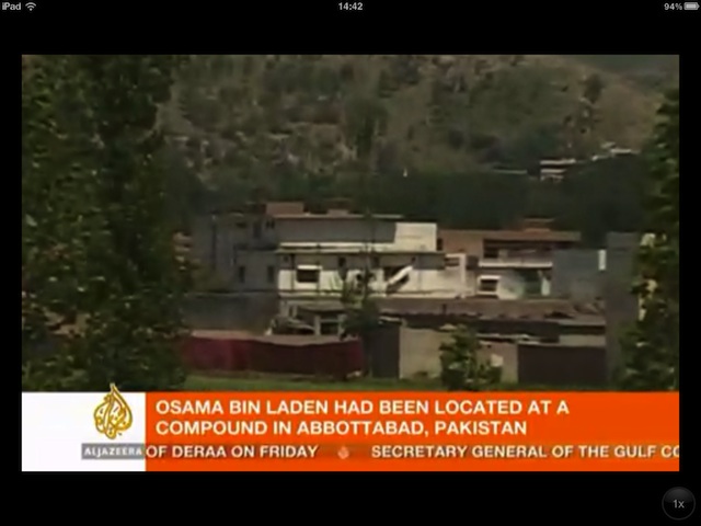
UPDATE 13:29 UTC: Here are screen grabs from Al Jazeera of the compound:
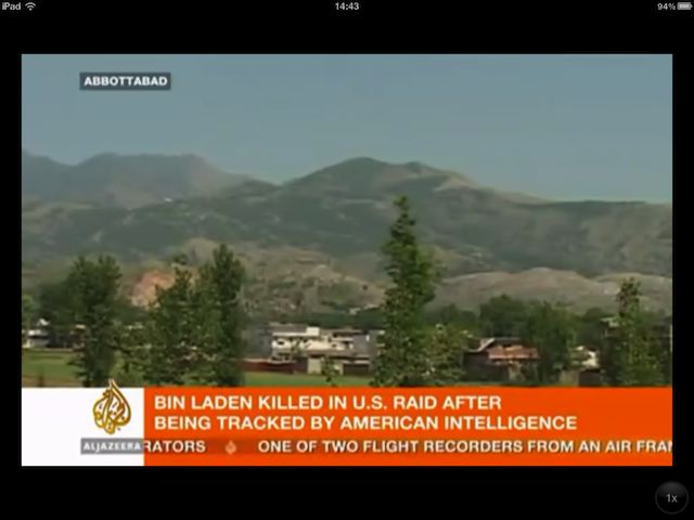
As you can see from the wide shot, the compound (not so much a “mansion” in terms of opulence”) faces the edge of an area with fields. Zooming in, we can see a section of red tarpaulin erected to hide ongoing investigatory activity. The mountainscape behind the compound can be reconstructed in Google Earth from the Bilal Town location pinpointed above. In other words, this is more evidence that Bin Laden’s compound is in the above location, most likely on the dirt road that runs along the creek visible in the Google Earth screenshots.

UPDATE 13:51 UTC: Here’s a screengrab of Al Jazeera’s map referred to above (via):
UPDATE 14:52 UTC: After a comment left by Dave (below), I took another look further to the west east of Bilal Mosque to see if there was any prominent construction there in 2005, in an area that is less built up than in Bilal Town proper. And indeed, there is one conspicuous compound that sticks out, and which closely matches the video imagery above. Here is the view in Google Earth in 2001:
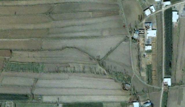
And here it is in 2005:
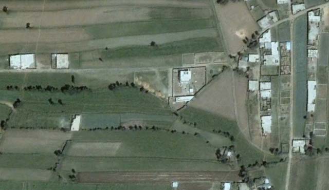
I think we have a very likely candidate here. (I’ve updated the map and added the location to the Google Earth KML file.)

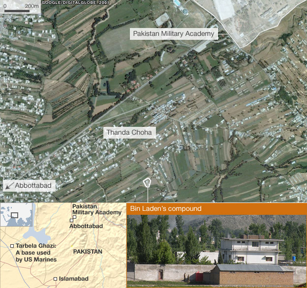
UPDATE 15:13 UTC: Published a few minutes ago, this new story by the BBC all but confirms that this compound is indeed the correct location, with a highly detailed map:


(Via maptd)

Thank you for playing everyone. We have a winner:


View Osama Bin Laden’s mansion location.kmz in a larger map

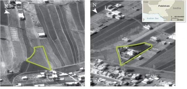
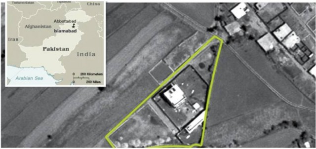
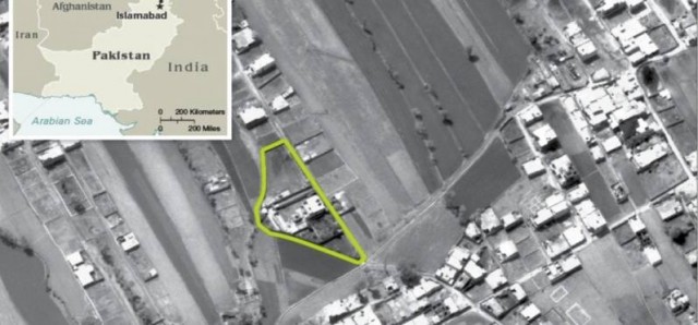
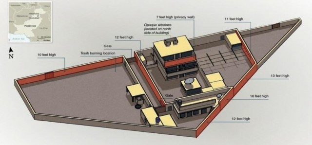
UPDATE 16:22 UTC: The CIA Pentagon releases aerial imagery confirming that this is indeed the location, as reported by the National Journal: (Click to enlarge. PDF of originals)
links for 2011-04-26

Google Earth Builder: A potential solution to the map censorship conundrum in China, India

Google Earth Builder, announced and previewed at this year’s Where 2.0, will — among other things — let government agencies publish their own maps and satellite imagery to the public, scalably, using the same cloud-y infrastructure that underpins Google Earth and Maps. That’s different from the existing Google Earth Enterprise product, where Google provides the software but not the servers.

What interests me most about Google Earth Builder is that it has the potential to release Google from a conundrum it currently faces when delivering maps internationally: Some of the world’s more overbearing governments impose onerous constraints on locally served maps — such as in China and India, both of which demand the drawing of incompatible borders and the removal of sensitive sites from maps. (This is why Google maintains separate sets of data for these locally-served maps.) China also insists that Google take responsibility for censoring any user-generated content it might want to publish. (As a result, Google’s local Chinese maps don’t publish user-generated content.)

With Google Earth Builder, Google can now play host to virtual globes without also being the publisher, thus relinquishing responsibility for the content. This allows for some interesting new arrangements.

While some governments have been happy to give Google their mapping and imagery data for use in Google Maps and Earth, viewing it as a free distribution model for a public good, other governments have chosen to view Google’s free maps as a threat: perhaps they balk at the free, advertising-driven nature of Google Maps, or the fact that Google’s maps are a for-profit pursuit by a private corporation. A more creative argument put forward in 2006 by France’s then-president Jacques Chirac states that the ability to serve online maps is a strategic technology for a state to have:

[…] Chirac stressed the need for France to have such a site […] saying the state had to be at the cutting edge of modern technology.

And indeed, France was the first of several countries to build a “Google Earth killer”. Géoportail, released in 2006, was followed in 2008 by India’s Bhuvan and in 2010 by China’s TianDitu. TianDitu’s virtual globe is homegrown, but with satellite imagery purchased from Digital Globe. Géoportail and Bhuvan, however, are both implementations of a mapping platform produced by Skyline, an American company. (So much for French strategic thinking.)

What all three geoportals have in common is that they are hardly best of breed, and certainly no “killers” of anything: Their 3D visualizations require Windows-only browser plugins, navigation is often unwieldy, and as launch difficulties betrayed for all these sites, scaling up is a big problem.

Google Earth Builder solves all these problems. Now a government can publish their own branded geoportal via Google’s infrastructure, using as much (or as little) of Google’s content it approves of and adding the rest. Google makes its money as a contracted service provider instead of through advertising, while the end user of the resulting product gets free maps that are inoffensive to the country footing the bill. (It’s not clear to me whether Google’s terms would allow somebody to sell their own ads against the maps to defray costs, or whether competitors like China’s Baidu could use Google Earth Builder.)

Once Google Earth Builder is available, Google has a new chip to bring to the bargaining table when dealing with regulatory issues surrounding maps in India and China (and potentially elsewhere). One thing that the chapter on China in Steven Levy’s recent book In the Plex confirms is the extent to which Google’s entry into and subsequent exit from the Chinese search market was fraught with a moral ambivalence that eventually outargued any profit motive. This ambivalence has not yet been resolved in Google’s China-facing mapping product, ditu.google.cn, which continues to toe the (border)line as China sees it. An ethical solution to the Google Maps conundrum in China, then, might involve shutting down ditu.google.com, but inviting the government or any number of private Chinese internet startups to adopt Google Earth Builder as their mapping platform, letting them instead engage in the arduous vetting process that precedes the granting of a web mapping license in China (which, by the way, Google is still without (via). It’s not even clear that Google has applied, which could mean that this scenario is very much in the process of unfolding.) Surely, some Chinese ex-Googlers will be interested in providing a technically superior albeit politically censored mapping service to the Chinese intranet…

The upshot: Google finds a way to get paid in an enormous and growing market, and at the same time is making sure that censorship invokes a cost. There’s a certain genius in that arrangement.

(A technical note: Google Earth Builder only seems to work with the Google Earth standalone client when accounts are used to regulate access (hence it would need Google Earth Pro or Enterprise). It therefore seems likely that any public-facing 3D maps made with Google Earth Builder will be a delivered via the browser and the Google Earth plugin.)

Short news: Afghanistan, barrier islands, Thai-Cambodian border dispute

  • Afghanistan I: The Wall Street Journal reports on how US forces in Afghanistan are ramping up the use of airdrops to provision troops in the field, so as to minimize the use of IED-infested roads:

    The air crews prepare for each mission by studying a three-dimensional Google Earth image of the line of approach, giving them a moving, cockpit-window view of the ridges, rivers and villages they’ll see as they near the drop zone.

    I wonder if the US military uses Google’s publicly available imagery dataset, or if they use Google Earth Enterprise and roll their own — because the publicly available imagery is at least 7 years old, and Afghanistan is conspicuously absent from the now semi-monthly updates.

  • Barrier islands: Researchers studying barrier islands have found that Google Earth’s imagery, especially if only a few months or years old, is much more accurate than the official maps and databases that are meant to keep track of them. They’ve now taken to scouring Google Earth’s publicly available dataset to “discover” over 600 such islands:

    “Basically nothing beats Google Earth for getting the whole story. Google Earth has opened up a whole new world for those who study physiography of the globe,” Pilkey said.

    Just as with people looking for archaeological discoveries or meteorite craters, the economics of free is compelling. It costs nothing to check unlikely places, which would never have been accessible when satellite imagery cost thousands of dollars to commission. As a result, the researchers discovered the world’s longest chain of barrier islands, off Brazil’s northeast coast, where they thought the tidal differences prevented such islands from forming.

  • Afghanistan II: This week, photojournalist and filmmaker Tim Hetherington was killed in Misrata will covering the conflict there. A few months ago I saw his much-acclaimed war documentary RESTREPO, about US troops setting up a remote forward base on a valley spur in Nuristan, surrounded by insurgents. Hetherington and fellow filmmaker Sebastian Junger embedded themselves with the soldiers over the course of a year in 2007. It’s a strong, compelling film.

    The documentary often refers to local place names and shows the maps used by soldiers, while the panoramic shots are distinctive enough that I thought it might be possible to identify exactly where the base was in Google Earth. Others on Google Earth Community had already beaten me to it. The precise location of Korengal Outpost (the main camp) is here, while OP Restrepo, the forward base, is here. Google Earth’s imagery is from 2004 and not of the highest resolution, but the digital elevation model is quite detailed, and provides very useful context when watching the film — which I highly recommend. (It’s available on Netflix)

  • Thailand-Cambodia border conflict: As you may have read, yet another temple on the Thai-Cambodian border is cause for a deadly military escalation. Called “Prasat Ta Khwai” or “Ta Krabey”, the temple straddles the spur that defines much of border between these two countries, and lies about 140 kilometers to the west of the much better-known Preah Vihear temple, which is the disputed site most often in the headlines these past few years. This temple is almost completely obscured by jungle coverage, but the link above and Geonames both triangulate to the correct place:
    View Larger Map

Freya Stark’s excursion in Afghanistan circa 1968 — mapped

At the very top of my to-do list for travel destinations lies Afghanistan, but over 30 years of war there have made it hard to justify visiting in the pursuit of pleasure. So I get my fix vicariously — most recently in London, where the British Museum is hosting a traveling exhibition with treasure from the National Museum of Afghanistan in Kabul. (It previously traveled around the US.) The curators have focused on material from four different archeological sites, each with a distinct cultural identity — Tepe Fullol’s gold bowls from the third millenium BCE show Mesopotamian influence; Aï Khanum was a Greek city; Begram‘s hoard shows strong links with Ancient Rome and India; and Tillya Tepe‘s burial treasures from the 1st century CE show a strong nomadic culture. The result is a remarkable survey of Afghanistan’s pre-Islamic heritage.

But it was in the gift shop that I made a serendipitous discovery — a travel diary by Freya Stark recounting her 1968 excursion by Land Rover straight through the mountainous heart of Afghanistan, from Kabul to Herat. “The Minaret of Djam — An Excursion in Afghanistan” had long been out of print, but was republished just a few months ago. I bought the book for two reasons: Because it is by Freya Stark, whose travel exploits are legendary; and because her destination is the Minaret of Jam (she spells it Djam) [Wikipedia], probably the most remote UNESCO World Heritage site and a long-time object of fascination for me.

The Minaret of Jam was built in steep, mountainous terrain in the late 12th century, at a brief and desolate opening of the gorges on the banks of the Hari Rud river. At 65 meters, it is still today the world’s second-tallest brick minaret, behind the 73-meter tall Qutb Minar in New Delhi, which is believed to have been inspired by the one in Jam and built specifically to surpass it. Both minarets were built by the Ghurid empire, and historians now suspect the Minaret of Jam is the only structure left standing at the location of Firuzkuh, or Turquoise Mountain, the fabled Ghurid summer capital destroyed by the Mongols in 1222 and lost to us ever since.

In an authoritative report on recent excavations at the Minaret of Jam in search of evidence tying it to Firuzkuh, David Thomas recounts how the wider world rediscovered this architectural gem:

In 1886, [Colonel Sir Thomas Holdich, the Superintendent of Frontier Surveys in British India,] published reports of a tall tower in central Afghanistan but it was not until 1943 that the minaret of Jam was ‘discovered’ by S. Abdullah Malikyar, the Governor of Herat, and A. Ali Kohzad published a report on it in Dari. A report in English followed in 1952 but the magnificent tower only received world attention in 1959, when Maricq announced the discovery in The Illustrated London News and suggested that its location was ancient Firuzkuh.

Nine years later, at the age of 75, Freya Stark set out westward from Kabul to see this minaret for herself. She and a few other seasoned travelers managed to drive their Land Rover Series IIA straight through this central massif, negotiating mountain passes, fjords and barely-there tracks to reach the minaret, and thereafter Herat.

Although there was very little road infrastructure then, the 1960s and 70s provided a rare window of opportunity for unfettered travel in Afghanistan — Herat and Kabul were major destinations along the Hippie trail. Stark’s encounters with Afghans on her excursion are wholly positive, with easy hospitality provided throughout. (It perhaps helps that she spoke Farsi, of which Afghans speak the Dari dialect). There is no inkling of the coming Soviet invasion in 1979, of the insurgencies of the Mujahideen and the Taliban, Al Qaeda’s presence, and finally, the NATO invasion in 2001.

As a counterpoint to Stark, it is worth reading Rory Stewart’s modern classic, “The Places in Between“. Stewart speaks Dari and is an Afghanistan expert, and yet his quest — to walk from Herat to Kabul via Jam in January 2002, through Taliban-controlled territory a few months after the NATO invasion — is brave bordering on the foolhardy. The landscapes he travels through are those which Stark visited 33 years earlier, but his descriptions above all convey desolation, desperation and a turning inward. Remarkably, he is often received hospitably on his trek.

Stark is generous with the minutiae of her trip. She records dates, places and distances, and offers up detailed descriptions of the landscape. For example:

A higher downland spread just above. A man who came to squat beside us while we ate, with a three-cornered Mongolian face and eyes as light as the mountain sky, told us that their center there is called Bâd-Asya, or Windmill; when we climbed to it we found three shops for a bazaar and a solidly built granary like those that Hadrian left along the Turkish coast for his armies, with the same government look about it though in a smaller way. A shambling lorry trundled off down an unlikely track, and half a dozen people sitting at leisure to watch it gave a city touch, since agricultural leisure never begins in the morning. The country to the south descended in slopes of light or shadow towards clefts that led to Ghazni or the Kabul valley far away. […]

We drove on, over a wide and lovely movement of heights, from one corn basin to another, jade-green and translucent in their own depth of shadow, and slung as if suspended between fox-coloured slopes. The dust-road rounded them with edges vague as smoke, transitory and perpetual as the centuries of forgotten hooves that had sodden and bruised it into the background of its hills; and suddenly, without any preparation, we found ourselves on the brow of a precipice that looked down on Helmand [river] escaping from its gorges. The river and a tributary met there, spitting white water and twisting like snakes surprised, and continued along an easier but still narrow valley journey, where a bridge at the bottom and the opposite zig-zags showed our way. [p.49]

Reading such passages, I began to suspect there might be sufficient information here to reconstruct her trip cartographically, using tools that the inhabitants of 1968 could not even imagine: Google Earth and geonames.org. It proved possible, but not easy. There were two main challenges:

First, in many places, the roads visible in Google Earth today had clearly not yet been built in 1968, so on several occasions we find Stark’s route veering away from the road which seems obvious to follow today. In the passage above, for example, they are on a track in the southern higher reaches of the Helmand river basin, because in 1968 there is no passable road directly beside the river. Today, there is.

Second, there is no common toponomy — Stark transliterates the names she hears in Dari from locals in one way, her maps transliterate them in another, and geonames.org does so in several more ways. (Google Earth’s own gazetteer is not usable in this particular region, with the few locations mentioned often off by many kilometers.) Fortunately, geonames.org has two very powerful tools: It has a KML network link for Google Earth that shows you its entries for your current view; and its website has a very robust fuzzy search function, with alternate names that more often than not nail what you’re looking for.

In the passage above, Stark hears the name “Bâd-Asya”, and writes it down according to her own rules for transliteration. geonames.org, however, lists “Sar-e Badah Siah”, where “Sar-e” denotes some kind of populated place. Sometimes, then, finding a location mentioned in the book took some creative reading of the candidates offered up by the network link as I roamed around the general area Stark would have traveled through.

Other techniques came in handy as well. Google Earth’s 3D perspective is especially useful in hilly landscapes like these, because it becomes s much easier to get a feel of the land, finding watersheds and mountain passes and seeing which valleys are flat enough for passage.

User-generated content was another useful tool for triangulating a location name. For example, on the first night, they camp at the edge of the Helmand river:

A hamlet of four houses was the centre of this small world, tucked at the foot of a promontory of rock and shale: Dané-Ausela they called it, but the map suggests Kizil-Bashi (Red-head) and the traveller can choose — as indeed he can with most of the smaller eastern names: the seldom agree with the maps, which never agree with each other.

Geonames was coming up empty, but then the Google Earth default photo layer provided the crucial hint, with a couple of rare Panoramio photos labeled “Dane-Awdela”. This in turn brought attention to a nearby Geonames place name: “Dahan-e ‘Abdullah“, a corroboration which in my mind confirms this as the place. There is no other name nearby remotely like it.

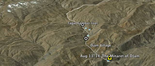
With techniques like this, I was able to map out the daily route of Stark’s expedition, from her departure in Kabul on August 8, 1968 to her arrival 8 days later in Herat. It’s available for download as a KMZ file, to be opened in Google Earth. The best way to use this tool is to buy the book and keep Google Earth alongside you as you read it. Doing so adds a whole new dimension to her travelogue.

I’m very confident about the accuracy of most of the map. In some parts, there is ambivalence about which specific route she took across a region, so I draw alternate paths. The route I am least sure about is the one she took on August 14. It begins and ends in the right places, but the path in between that fits with most of the evidence does not pass a certain nearby village she says they drove by. However, Stark refers to the village noncommittally as “a place which seems to be called Margha on the map”, so it’s possible that in this instance, she read the map wrong. In any case, the KMZ file comes with the Geonames network link included, so you can easily build your own theories. Any corrections or suggestions are welcome.

The above KMZ file contains some further “bonus” content. At the start of her book, Stark describes a visit to he Buddhas of Bamian, and I’ve marked up the relevant place names there. (Stark calls them “the huge, and lets face it, ugly Buddhas”, but is spared any regret she might have felt at her choice of words when the Taliban demolish the Buddhas in 2001 — She died in 1993, a centenarian.) She also mentions the northern cities of Balkh, Tashkurgan and Kunduz, and a series of passes. I’ve marked those up as well.

Finally, I have also added the locations of the sites whose treasures are in the Afghanistan exhibition currently on show in London. Tepe Fullol in particular is an obscure, out-of-the-way site.

I will admit that I have on occasion lurked on Lonely Planet’s Thorn Tree travel forum, looking for safety information on the Kabul-Jam-Herat trip. The advice varies by year. In 2007, it was deemed safe to travel from Herat to Jam. In 2010, not so much. Places like Panjau also seem to have changed in character. When Stark passed by it was “a miniature village-town with some signs of coquetry about it”. By 2010, one seasoned traveler described it as “a s**t-hole filled with yucking yokels, only worth getting out of.”

Let’s hope Afghanistan will be over its troubles by 2018, the 50th anniversary of Freya Stark’s excursion. Perhaps then would be an opportune time to retrace her trip. The research has been done. Who’s in?

Recent reads: Libya, World Heritage Network, Japan

IMINT & Analysis: Libyan NFZ: The SAM Threat
Sean O’Connor over at IMINT & Analysis has a thorough exposition of the Libyan anti-aircraft surface-to-air missile bases that the US and UK Tomahawk missiles have likely been targeting.

Separately, IMINT & Analysis also updates the available intelligence on the newest class of Chinese submarines, spotting one in the North Sea Fleet in the latest imagery available on Google Earth. The submarine in question is moored outside the “secret underground submarine base” much-blogged here on previous occasions.

Global Heritage Fund: Global Heritage Network
The Global Heritage Fund, a non-profit dedicated to preserving the world’s cultural heritage, has just launched Global Heritage Network, a very impressive browser-based augmented Google Earth application that overlays all manner of geospatial information over threatened world cultural sites. Included in the entry for Kashgar are some of the photos I took in August 2010 (blogged here). I found this web app to be surprisingly usable and useful — often, these kinds of projects don’t work beyond being a technology demonstration. (To get a URL link for a view of a specific location, perform a search for it and click on the resulting link.)

Nikon Rumors: Satellite images of Nikon Sendai plant before and after earthquake
Goole Earth and Maps has been used in many ways to document the the earthquakes and the tsunami’s devastating effects in Japan this past week (See Google Lat Long Blog, Japan Quake Map). One more unusual use of the post-tsunami satellite imagery was by Nikon Rumors, which was able to confirm a lack of damage to one of the main Nikon factories, located in Sendai. No doubt equity analysts the world over are doing the same so as to adjust their portfolios. One thing to remember when looking at the before and after imagery: It can only show damage to physical capital, not human capital — it won’t tell if or how many Nikon plant workers, living nearby, perished.