All posts by Stefan Geens

Lebanon update in Google Earth soon?

Live from GeoWeb 2006, a contributor writes:

[Google Earth CTO] Michael Jones said he’d been up all night writing position papers because Google will be posting all of Lebanon later today.

They are expecting that there might be a reaction to the seemingly one-sided information.

If that’s confirmed (nothing yet, as of this writing around 60% of Lebanon is in high resolution, and none of it from 2006) that would be an impressive and quick response to current events. Applications like Google Earth become especially valuable if they are able to rapidly reproduce new “facts on the ground” in cases of natural disasters or wars.

That said, I can imagine Michael Jones must be apprehensive about wading into this conflict in an region where nuance or neutral information is always construed by both sides as abetting the enemy. Still, we’ve already seen the perspective from the ground on TV. Let’s see the perspective from the air. The more information the better.

Short news: Popularity contest; GeoWeb 2006; Panoramio

I’m on the road — Paris tomorrow for the Google Earth usability test (as long as nobody tries to attach electrodes to my head they’ll be fine) then off to Belgium for a family visit. But first, some news:

  • Over at the Earth is Square, a commenter points out that NASA World Wind is just short of its ten millionth all-time download. With Google Earth having been downloaded 100 million times just recently, does this mean that Google Earth enjoys 91% market share vs. NWW’s 9%, roughly speaking? Or would it depend rather more on who comes out with the most versions over time, which would require more repeat downloads?
  • I had this ready but Andrew Turner was too quick for me and has already left a link in my comments: High Earth Orbit‘s authoritative list of Mac GPS software.
  • Stefan Lorimer writes up GeoWeb 2006.
  • Panoramio‘s KML feed is new and improved. Writes Eduardo Manchon:

    Now it’s more responsive (it downloads all previews on one shot), prettier (frame around thumbails, bigger images, panoramio’s logo) and more informative (titles on mouse over, name of the location, …). Hope you like it.

And now for something completely different: Press releases.

  • Geometric Software’s eDrawings:

    eDrawings for Google SketchUp provides an innovative way to share your designs. You can publish your SketchUp models to eDrawings files that can be packed into a self-executable (.exe). The self-executable file contains the viewer as well as the design data. [Windows only, obvs.]

  • CarbonTools Pro for .NET (third generation):

    .NET developers can now use the location content they want, wherever (or whoever) it comes from – Google Earth KML, OSGeo MapGuide, Yahoo Maps, […]

  • “Eloquent Systems Improves Global Access to Systems for Museums, Archives and Heritage Societies”:

    The VisualSearch interface is a mash-up that combines geospatial tools such as Google Maps and Google Earth with the rich information described in collections hosted by Eloquent’s clients.

  • RealViz comes to Google Earth (MacWorld, Mac New Network):

    The move means that [Mac] users can display images within Google Earth — including panormas, 3D models, virtual tours and other material created with Stitcher, ImageModeller and VTour.

    The only problem is that neither article, nor the RealViz website, explains how exactly this is meant to happen. How do we add the metadata? Do we get a KML file as a result? Do we get to share it with others? It’s a mystery.

Haret Hreik – before and after

Via FrenkelX – Israeli headlines Xplained, I came across this DigitalGlobe photo (1.9MB) of Beirut’s Haret Hreik quarter — Hezbollah’s stronghold — taken after the Israeli bombardments of the past forthnight.

Since Google Earth has a similar resolution base image taken on February 15, 2005, I placed this new imagery as an overlay in Google Earth. Here is the KMZ file. The images are taken at different angles and times of day, but the before/after comparison deftly portrays the effect of the bombardment there.

Bear in mind that this is the kind of visual intelligence that all the actors there are privy to: Israel, the US, Iran, Syria, but also the UN and humanitarian agencies, and thus also displaced residents looking to see whether their homes are still standing.

Short news: Lebanon KML redux; Bay Area usability study

  • If you haven’t done so recently, take another look at the KMZ file of the current Israel-Lebanon war (originally posted on here). It’s kept up with events on both sides of the border, and now comes with folders for individual days. There are also very recent overlays of Getty Images showing Beirut airport and Jiyeh after the air attacks.
  • If you’re a regular Google Earth user and will be in the Bay Area (California) between 1-8 August, take part in a usability study and you’ll be $100 richer for your troubles. Apply here. (I’ll be doing mine in Paris this Friday. Should be fun:-)

New satellite imagery of nuclear plant in Kushab, Pakistan

All Points Blog pointed me to an article in the Belfast Telegraph which noted that the Institute for Science and International Security (ISIS) has published a report that contains recent satellite imagery of a new, much larger nuclear reactor being built in Kushab, Pakistan — one which would be capable of producing enough plutonium for 40-50 nuclear weapons per year in a region that came close to waging nuclear war as recently as 2002.

I took the images in this report and overlaid them onto Google Earth. ISIS says work started on the reactor sometime after March 2000. Google Earth’s base layer, which is in high resolution, was taken on January 15, 2004 (link). The images made available by ISIS were taken on June 20, 2005 and April 2, 2006.

2004image.jpg

2004 (image Credit: Digital Globe)

2006image.jpg

2006 (image Credit: Digital Globe)

Here is the KMZ file. By default, the 2005 image is turned on and the 2006 image is turned off. You can also play with them using the opacity slider.

The original report is well worth reading. It points out the dangers of a regional nuclear arms race between India and Pakistan, and the risk that China might also feel obliged to join.

And let’s not forget that the current US adminstration’s policy of providing an exception to India regarding the Nuclear Non-Proliferation Treaty means that other countries pursuing nuclear weapons can rightly accuse the US of hypocrisy. For more, I found this opinion piece in the San Francisco Chronicle today by House International Relations Committee member Barbara Lee to be particularly timely. This leader in this week’s The Economist is just as unequivocal.

RouteBuddy for Mac revealed

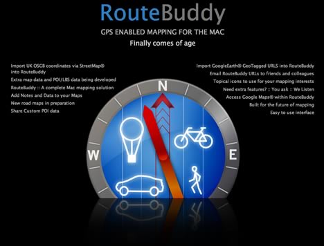
OK, now I understand what it is: RouteBuddy is software to turn your Mac and connected GPS device into a car navigation system. The website even explicitly suggests turning your Mac mini into an on-board computer. This also explains why you’d want to buy road maps — they’re for going places where you have no internet access.

But at $100 for RouteBuddy + $600 for a Mac mini + $100 for a USB GPS device + $200 for a flat screen + $50 for a map + installation, you’re not going to be cheaper than a Tom Tom or Garmin Nuvi, unless you already have a Mac you can repurpose.

The main problem, however, is that RouteBuddy can’t give you directions, which TomToms and Nuvis can. So is RouteBuddy then more of an editor and repository for your GPS waymarks and routes? Yes, except that you can’t export your content as KML or GPX or anything other than a proprietary RouteBuddy file, which is really just another kind of XML file, and which others can only use if they also purchase RouteBuddy (and the relevant maps). If they do, then they can indeed upload your waymarks and routes to their GPS device. But why go through all that hassle? And why, as you’re not in a car when you’re doing all this, pay for maps that you can get for free on the internet, such as Google Maps, Yahoo Maps and Google Earth? All of these can also give you satellite imagery, which RouteBuddy does not.

As for integration with Google Maps and Earth: You can indeed open a Google Maps or Yahoo Maps permalink in RouteBuddy, and you can also turn your current RouteBuddy view into the same view in Google Maps or Google Earth.

The verdict: Until RouteBuddy can give directions, and until RouteBuddy can export to industry standard file formats, this 1.0 application is not as useful to me as some fine free Mac software I recently reviewed. But the FAQ does promise “that there will be a free Routing and Intel upgrade as soon as they are available.” Perhaps I’ll take another look then. But check it out for yourself; there is a free demo available, with map data for Santa Fe.

Routebuddy: GPS mapping for Macs (later today?)

Well, the teaser site sure looks ultra slick. Routebuddy — “GPS enabled mapping for the Mac finally comes of age”:

routebuddy.jpg

MacWorld is reporting that this Mac only application will be launched later today. Very little further information is available at this point:

Additional confirmed features include: support for adding notes and data to maps, the capacity to import Google Earth URLs into the application, direct support for emailing maps and directions.

Application prices and shipping schedules haven’t yet been announced.

The teaser site itself says “Import GoogleEarth GeoTagged URLS into RouteBuddy.” Not sure what those are. Perhaps they are referring to KML files? I do hope Routebuddy will also let you export to KML.

And MacWorld says “Routebuddy users can extend the solution by purchasing new maps from the company.” Considering what I can get for free these days, those better be good maps.