All posts by Stefan Geens

Canary islands in a coalmine?

We’ve already heard the news that a recent dataset update for Google Earth replaced images of the Canary Islands by DigitalGlobe from 2005 with images from 2002 (or thereabouts) by Grafcan, a publicly owned local company, after an agreement between Grafcan and Google.

Though several people tipped me off about this story, I wasn’t sure how newsy it was — after all, it’s a big world, and this kind of local hiccup in the data is bound to happen sometimes. I thought the most remarkable thing about this item was that the locals seemed to be quite adamant that Google Earth should have recent imagery — an implicit tribute to the authority Google Earth has gained as geographic refence material.

I also assumed that the Canary Island’s local authorities were keen on having accurate imagery so as to attract tourists. This assumption is questioned by the local greens, however. A new article reports that the green party is accusing the authorities of trying to obfuscate the extent of recent development on the Canary Islands by feeding Google Earth old data via Grafcan. A local local green’s blog post repeats the accusations.

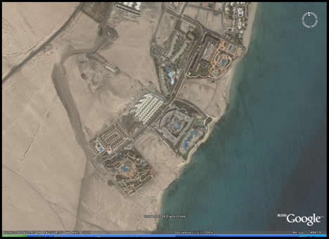
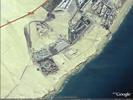
For the record, here are some screenshots sent in:

Before the dataset update:

before.jpg

After the dataset update:

after.jpg

I’m not taking sides:-)

Geonames.org gets a network link

I often use Geonames.org to find the precise location of obscure places in Google Earth, doing a search and then linking back from the results to Google Earth or Tagzania. If you know the approximate location, however, you can now do much better: A recently introduced Geonames network link will show you everything in its database for your particular view. It’s the perfect triangulation/confirmation tool for the information available in Google Earth’s Google Earth Community layers.

In other words, this network link is a keeper, especially if you need to find that out-of-the-way wadi or minor mountain peak.

Short news: Wikimapia; Geoweb 2006 writeup

  • NetNewsAsia reckons Wikimapia is being used as a “global toilet wall and killer’s confessional.” How does Google Earth Community avoid such a fate? By having user accounts, for one. Meanwhile, Wikipedia makes sure every addition or alteration is peer-reviewed soon after it is made. In Wikimapia, each item has a link for reporting it as inappropriate. Will that be enough? What if the morbidly tagged locations were in fact accurate?
  • Stefan Lorimer at Graphics, Culture, and Bad Grammar posts his notes on Google Earth CTO Michael Jones’s talk at GeoWeb 2006.

Deep network linking: Good, bad or ugly?

Get Amazon A9’s street-side photos via a network link. That’s a pretty amazing demonstration of how one service’s content can be repurposed onto another’s platform. Simply zoom in over an area that has coverage (try the East Village, NYC) and wait for the network link to return a placemark with a link to the appropriate photo. (Via Le Blogue du LFG – Guadalajara, Mexique)

stmarksa9.jpg

The “brain” of this network link is an ASP script on www.thechajoneri.se. This is not the first instance of such a mashing up of services: An early network link let you put Google Maps tiles on Google Earth, and a more recent one (also by www.thechajoneri.se) puts tiles by Swedish mapping service Eniro onto Google Earth. When somebody wrote an add-on for World Wind that puts Google Maps tiles onto that globe, it was removed at the request of Google. You can, however, get Microsoft Virtual Earth tiles superimposed on World Wind, because this add-on is sanctioned by Microsoft.

What’s the legality of (unsanctioned) scripts powering network links? They are definitely parasitic — the result is that the bandwidth and efforts of the host company are used without the host company being able to generate revenues from this. But all that the scripts actually do is generate URLs for deep links into a publicly available image database, and that deep link is just the same as any other deep link on the web. As far as I know, if it’s publicly available and you can link to it, there are no legal recourses for the linkee. In fact, “linking policies” that try to regulate how you may link to a website regularly get ridiculed on Boing Boing.

One thing that should not distract from the legal question is the type of browser used to display the content of deep links: Whether a Google Maps tile is displayed “naked” in a web browser, via a network link in Google Earth, via a network link in ArcGIS Explorer or via a World Wind add-on is not relevant — these are all unintended uses. A network link is a snippet of KML, and thus can/will be used by any number of geobrowsers, not just Google Earth.

SketchUp: A question of support

Google SketchUp has revamped its help center, wrote Google employee Bil Eberle a few days ago to the SketchUp Pro forum. As a result, the direct email support link for pro users has been moved to the end of each help center article, to encourage users to first look for solutions to their problems there.

This generates a minor tempest in a teacup in the ensuing thread, because several customers simply cannot find the link for email support, probably because they actually haven’t tried to solve an actual problem by drilling down to an actual help article, as suggested by Bil. But I suspect that the real reason for the snippiness of the pro users is still down to the fact that most of a product they paid for is now free for personal use (minus email support.)

In any case, the direct link to email support is here. You can also use it for feedback, to report a problem, and for “Other”.

Bonus SketchUp resource: SuWiki, a wiki about SketchUp. It’s still being filled in, but the section on Tools is already very useful for those just starting out.

Weekend project: Atlas Gloves for Google Earth

Finally! After a few months of tweaking, Dan Phiffer and Mushon Zer-Aviv are ready to go public with the code for Atlas Gloves, their DIY hand gesture interface for Google Earth that let’s you pretend you’re fighting precrime in Minority Report. Get a webcam, make some ping pong ball lightbulbs, download the free Java application for Windows, Mac or Linux, and try it out. (Here is a short video demo if you need an introduction.)

atlasgloves_diy181.jpg

I haven’t have a chance to try it yet (I’m on the road) but I didn’t want to keep this all to myself in the meantime. If you try it, do let me know how it goes. Source code is also available.

Short news: Download numbers game: Canary Islands

  • Popularity contest redux. I have it on good authority that the 100 million figure cited for Google Earth downloads in June 2006 was in fact “for unique user activations (not downloads).”

    Meanwhile, equal time for The Earth is Square.

  • Middlesex University’s Steve Chilton writes:

    It might interest your blog-readers to know of a workshop on Google Earth that is being held as part of the Society of Cartographers Summer School this September. The course is at Keele University (UK) from 4-7 Sept, with the workshops on Wed 6 Sept. The Google Earth workshop is being run by Richard Treves. Richard is a tutor on an MSc at Southampton University. (Web course.) Full details of the summer school, which looks at the wider world of cartography, are here. Programme summary here.

  • Interesting article in a local newspaper of the Canary Islands (in Spanish). Apparently, local imaging firm Grafcan made a deal with Google to supply the high resolution imagery for the Canary Islands — except that it dates from 2002, and now the locals are clamoring for imagery from 2006, which has been promised soon. (This is the kind of problem you want to have, really). For the record, zoom in on the Canary Islands and Grafcan is indeed credited for the imagery.
  • Hmm. For Forbes, Rich Kargaard writes in his Digital Rules column (registration required):

    Recently I got a peek at a future version of Google Earth, which will showcase a much-improved 3-D depiction of terrain and buildings. This cool software could make tons of money–from ads.

    Imagine using Google (nasdaq: GOOG – news – people ) Earth to zoom low on a city street. Gone is the old pancake-flat look of buildings. They will be depicted in stark relief. And here’s the moneymaker: Addresses that have bought ads, such as restaurants, shops or commercial buildings for lease, will stand out as a cut above the rest–in perfect, rich detail and color. Click on one of these buildings and you’ll be whisked away to the establishment’s Web site.

    Not sure how much of that is meant to be new or speculative. He goes on to review Zillow.com and writes about how both Google and Zillow are about to “scarf up real estate ad revenue” that would otherwise go to newspapers.

  • TJMartin is also blogging GeoWeb 2006, and he seems to have a confirmation from Microsoft Virtual Earth’s Steven Lawler that their upcoming 3D building content won’t be user created (unlike what Google’s tactic seems to be for Google Earth, with SketchUp). That’s not a surprise, of course, especially after their purchase of Vexcel and GeoTango, photogrammetry experts both, but it’s a good thing to know.