- Cool science use: UNAVCO “supports and promotes Earth science by advancing high-precision techniques for the measurement and understanding of deformation”. Now they’ve published links to all their measurement data geospatially, as KML.
- Where are the antipodes of Mecca? Curious minds want to know.
- Frank Speirs’ FlickrExport for Aperture 1.0b2 adds Google Earth support. Frank also reports a significant EXIF bug in Aperture 1.5. (Aperture is Apple’s pro photo tool.)
- Uberpretty virtual planetarium Stellarium is up to version 0.8.2 for PC, Mac and Linux. Best part: The Mac version is now a universal binary. (Via Le Blogue du LFG)
- Somebody give that man an impossible task. Valery Hronusov comes out with a demo of 3D isosurfaces. Good for measuring blast radii of North Korean nukes, I presume. (Comes with a pretty picture.)
- BTW, if Valery gets his visa (who knows these days, right?), you’ll catch him at the AGU in San Francisco December 11-15, participating in ED21: The Use of Internet-Based Virtual Globes in the Earth Sciences.
All posts by Stefan Geens
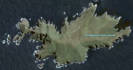
“New” Sub-Antarctic Islands get high resolution treatment
Some people have a predilection for hunting down planes or flying cars in Google Earth. My weakness is for sub-Antarctic islands. The dataset update from October 3 was particularly rewarding in that regard. High resolution imagery is now available for Heard Island, Possession Island (the French one), a sliver of Marion Island, Gough Island, and my favorite, Disappointment Island, site of a great shipwreck story. I’ve collected them all in a handy KMZ file so you can take a tour at your convenience. Here is a teaser:
Google eArt II
Little did I know that when I titled my last post about the intersection of art and virtual reality “Google eArt”, I’d get every misspelled google search end up on this blog. So here goes another installment:
The electromagnetic field of a Florida substation was turned into an installation piece made to scale by Locust Projects Nicolas Lobo at the Locust Projects art space:

Of course, the project wouldn’t be complete without its virtual complement in Google Earth:
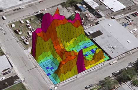
Here is the KMZ file. Geospatial context as art. Love it.
And then there were nine — Netherlands gets address search
Webmapper reports that maps.google.nl is now live. A quick check reveals that Google Earth now also does directions between specific addresses in the Netherlands:
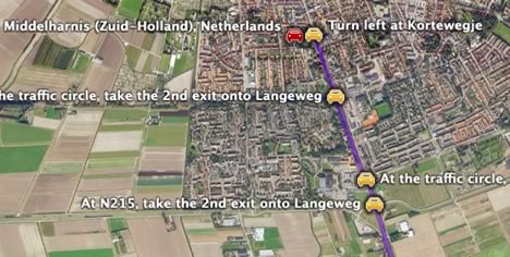
Webmapper goes on to list content partners for restaurant reviews in Google Maps — these haven’t made it to Google Earth yet. In case were keeping tabs, it’s now the UK, France, Germany, Italy, Spain and the Netherlands that get “full-service” coverage in Europe, in addition to Japan, Canada and the US. (Semi-interestingly, the UK, Canada and the Netherlands only get directions at the moment in Google Earth — no yellow-pages type content.)
Short news: Hidden Google Maps support in iPhoto?
- Interesting: Craig Stanton pointed me in the direction of this find: a post on a MactelChat bulletin board, “iPhoto 6.0.5 shows evidence of Google collaboration“. It could be an unauthorized easter egg, but there appears to be a hidden button that links EXIF in iPhoto to a view in Google Maps.
- Bizarro reporting by Turkish news source Zaman:
While a middle-aged man was sunbathing on his balcony, he was caught by one of the Google Earth users. A photograph taken by the user was published on the Internet. After a while, photos of women that were taken secretly were published on the Google Earth Forum. A Dutch woman was sunbathing on the roof of her house in the Hague. Photos of many people, taken secretly, began to be published on the Internet.
Yep, that’s definitely how Google Earth works — when we fly around the globe at home, an actual satellite obeys our every whim, live.
- A web-based resource for geoscience visualizations by the Science Education Resource Center at Minnesota’s Carleton College gives a good overview of Google Earth and its many uses in geoscience for visualizing data.
- Rich Gibson, co-author of Mapping Hacks (published by O’Reilly) is not happy about having gotten a “take-down letter” from Google regarding some code available online that he wrote that let you download Google Maps tiles.
Have I got a CAGE for you!
What has the Indian government been up to regarding Google Earth since the last time we checked? The Hindustan Times provides an update. On October 2, it reported:
Sources said that at a high-level meeting convened by Cabinet Secretary BK Chaturvedi in September, it was proposed that the Ministry of External Affairs (MEA) should raise the [Google Earth] issue with the US at a bilateral level. […] New Delhi believes that there should be an international agreement that before satellite pictures are taken over a particular country, the permission of that country has to be taken.
That’s a brilliant idea. How might that work in practice? Let’s explore with this one-act play:
LOCATION: GOOGLEPLEX, MOUNTAIN VIEW, CA
TIME: SOMETIME IN THE NEAR FUTURE
ENTER STAGE LEFT — GOOGLE EARTH CTO MICHAEL JONES, WITH MOBILE PHONE
JONES IS ON HOLD, HUMMING ALONG TO A MILITARY MARCH. THEN A MUFFLED VOICE IS HEARD.
JONES: Oh, Hello Mr. Kim Jong Il, thank you for taking my call. It’s just a courtesy call, really. I was just wondering if it would be allright to add some new satellite imagery of your country’s lovely natural resources to our virtual globe, Google Earth. I’m guessing it would do wonders for your touri… No? But… [CLICK HEARD] Bastard hung up on me. Okay, who’s next? [HITS THE NEXT SPEED DIAL NUMBER. AFTER A WHILE, IT RINGS, AND SOMEBODY PICKS UP.] Good afternoon, President Bashir. How is Sudan looking today? Look, have I got a proposal for you… [CURTAIN]
Please note that the Hindustan Times article is entitled “Coalition against Google Earth”. That is truly inspired copywriting, and I hope the acronym sticks — after all, who wouldn’t want to join a CAGE?
PS: Google’s PR response team obviously picked up on that article, because the very next day, the same paper carries every argument you can reasonably make as to why public access to satellite imagery is a net public good.
Darfur
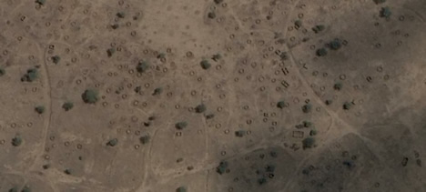
Those circles aren’t animal pens. They’re burned-down gottias, circular mud huts that had straw roofs, and they’re what’s left of Dalia, a village in Sudan’s Darfur region, one of hundreds of villages that have been destroyed by the Janjaweed in a program of depopulation that has killed perhaps 400,000 civilians since 2003.
Today, Google added recent high resolution imagery of Darfur to Google Earth, taken by DigitalGlobe in January-March 2006. It serves as an unequivocal indictment of the Janjaweed, and of the Sudanese government whose implicit support it has enjoyed, because in these new images each and every burned-out gottia is visible. This is the kind of evidence that puts paid to the claims still coming out of Khartoum that the ethnic cleansing is not widespead, and that accusations of genocide are a mere pretext to wrest sovereignty away from Sudan with the deployment of UN peacekeepers.
But this evidence also makes it harder for us remain complacent. We can no longer pretend we didn’t know. A number of humanitarian agencies have been documenting the tragedy of Darfur, mapping burned out villages and recording oral histories in the refugee camps. Some of these data will soon be published as KML — I used pointers from one draft version to highlight 15 of the destroyed villages visible in the imagery released today. Here it is. Zoom in close. This is just a minuscule subset of the devastation in Darfur.