-
Does China have a new internet maps regulator?
-
Google updates its maps for Abbottabad with satellite imagery taken on May 9, 2010, and says it will soon also incorporate the post-raid imagery taken by GeoEye on May 2, 2011.
Yearly Archives: 2011
GeoEye publishes post-raid satellite image of Bin Laden compound
Via the Map Room, news of a brand new satellite image taken today, after the raid on Osama Bin Laden’s compound.
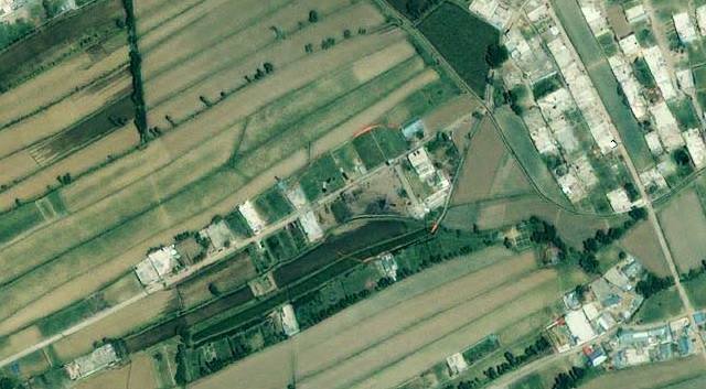
It’s by GeoEye, and the caption reads thus:
This one-meter resolution image shows a walled compound in Abbottabad, Pakistan. According to news reports Abbottabad is the town where Osama bin Laden was killed by U.S. forces. The image was collected by the IKONOS satellite on May 2, 2011 at 10:51 a.m. local time while flying 423 miles above the Earth at an average speed of 17,000 mph, or four miles per second.
That would place the timing of the image at just under 10 hours after the attack.
What it lags in resolution vs the DigitalGlobe image from January 2011 (blogged previously) it makes up for in terms of timeliness and color. In fact, the crash site of the problem-helicopter seems plainly visibly (to my eyes) as a blackened helicopter-shaped mass. While there are photographs around of helicopter chunks eventually being hauled away, this satellite image seems to have been taken before then:
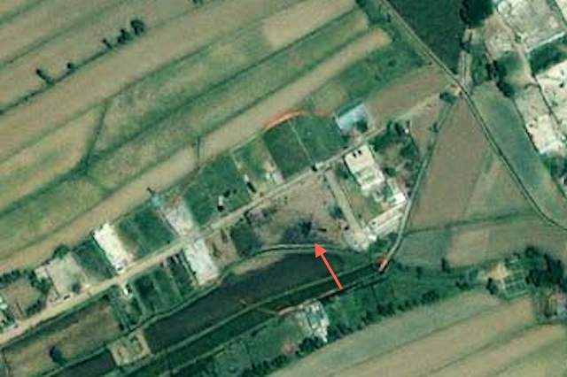
As with the DigitalGlobe image, it looks great when overlaid on Google Earth, so here is the KMZ file (2MB). As usual, play with the opacity slider to compare vs the older imagery from 2005 below it, and remove the outline of the compound to get a better look.
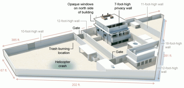
UPDATE May 3: A graphic made by the New York Times places the helicopter crash at the same location as indicated in the image above:
[Update May 3: Google today updated its base image layer to include imagery from Abbottabad taken on May 9, 2010 — just under a year ago. You can still see the imagery from 2005 (and 2001) by using the historical imagery time slider tool in Google Earth.]
In the Situation Room, aerial imagery of the Bin Laden compound
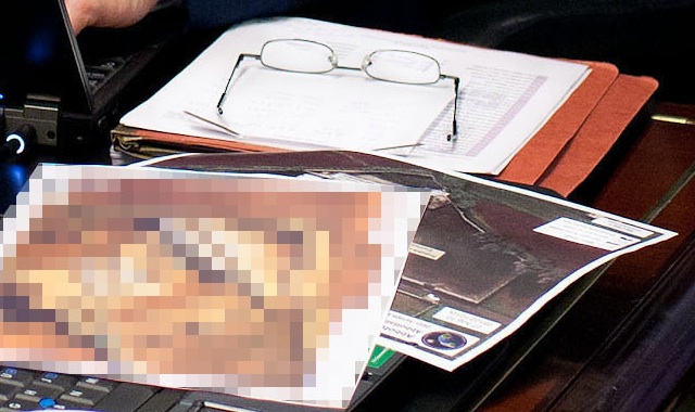
A closeup of that photograph making the rounds of Obama and his team following the raid on Bin Laden’s compound in the Situation Room: (Click to enlarge)
Sure enough, it is an aerial surveillance image of the compound. Also note that “a classified document seen in this photograph has been obscured,” as the caption puts it. What’s interesting is that this document too — for as far as I can tell through the pixellation — looks like a highly detailed aerial image; probably so detailed that the US military would rather us not know just how detailed it can get.
2011 DigitalGlobe imagery of Bin Laden compound, now on Google Earth
UPDATE: A new post: GeoEye publishes post-raid satellite image of Bin Laden compound
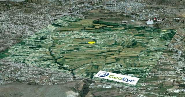
Via a comment left under the previous post here on Ogle Earth, a pointer to just-released high-resolution satellite imagery of Osama Bin Laden’s compound, published by DigitalGlobe to their Flickr account. Dated January 15, 2011, and showing a scene with denuded trees, the black-and-white image clocks in at 5368 × 5719 pixels, making it an ideal image to place as an image overlay into Google Earth.
So without further ado, here it is as a KMZ file to be opened in Google Earth. It’s 6MB, so give it some time to open. As usual, play with the opacity slider on the left-hand side to compare the base imagery (from June 15, 2005) with the updated B&W imagery from 2011. I’ve also added an outline of the compound; feel free to turn that off to get a better look.
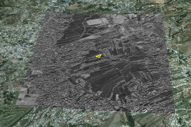
As you may know, there is also a layer in Google Earth that outlines the locations of DigitalGlobe satellite images taken over the years (under “More”). I actually went looking there today to see if there had been any recent activity over Abbottabad, because in past cases (such as when Israel destroyed a nuclear reactor in Syria in 2007), an area of close interest to a DigitalGlobe customer would later show itself to be the location of a military strike. The most recent date shown for a DigitalGlobe image of Abbottabad is 2006… followed of course by the current image from January 2011. So could we have known (with hindsight) that something was up in Abbottabad? No, because Google Earth does not yet show where DigitalGlobe imagery for 2011 has been taken. The above image is too recent!
(For older coverage of the Osama Bin Laden compound’s location, check out my previous post.)
[Update May 3: Google today updated its base image layer to include imagery from Abbottabad taken on May 9, 2010 — just under a year ago.]
Finding Osama Bin Laden’s Abbottabad mansion with Google Earth
UPDATE: Scroll to the end of the article to see the final confirmed location of the compound.
UPDATE 2: A new post: 2011 DigitalGlobe imagery of Bin Laden compound, now on Google Earth
UPDATE 3: More posts: GeoEye publishes post-raid satellite image of Bin Laden compound, In the Situation Room, aerial imagery of the Bin Laden compound.
Osama Bin Laden’s death first manifested itself as short news items on Pakistani news sites: “Copter crashes on Kakul road – Monitoring Desk“, and indeed, later we would hear that one of the helicopters used in the raid on Bin Laden’s compound was damaged and destroyed.
The repercussions of Bin Laden’s death are still uncertain, but this post will just concern itself with the location of this compound. Where exactly was it? Can we find it on Google Earth?
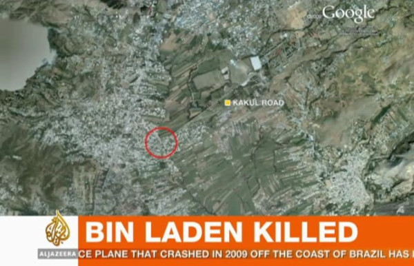
Al Jazeera English mentions “a mansion” surrounded by high walls, comprised of “boxes” with no windows. On a map of Abbottabad shown on their screen, Al Jazeera shows Kakul Road, and marks a specific location on that road, at the edge of some fields.
In a news story sourced to CBS/Associated Press, we get an eyewitness to tell us the following:
“I heard a thundering sound, followed by heavy firing. Then firing suddenly stopped. Then more thundering, then a big blast,” he said. “In the morning when we went out to see what happened, some helicopter wreckage was lying in an open field.”
He said the house was 100 yards away from the gate of the academy.
The New York Times reports that the mansion was “on the outskirts of the town’s center, set on an imposing hilltop and ringed by 12-foot-high concrete walls topped with barbed wire.” It goes on:
The property was valued at $1 million, but it had neither a telephone nor an Internet connection. Its residents were so concerned about security that they burned their trash rather putting it on the street for collection like their neighbors.
American officials believed that the compound, built in 2005, was designed for the specific purpose of hiding Bin Laden.
Is it possible to correlate these disparate clues? Not really. The NYT is most likely to be wrong as to the location — Al Jazeera footage shows a backdrop of flat fields near the compound, not a hilltop. Also, from the position marked by Al Jazeera on the map, the front gate of the military academy is around 2km away along the straight Kakul road, rather than the “100 meters” mentioned by the AP eyewitness.
I am inclined to give Al Jazeera the benefit of the doubt on this. They are the most likely to have people on the ground with the correct information, they are specific in their pinpointing of the location and their video footage supports their map.
But there is one further clue we can use. Google Earth’s high-resolution map of the area has imagery from June 15, 2005 — almost 6 years old. One set of older imagery is available — from March 23, 2001. If the NYT sources are correct on Bin Laden’s mansion being under construction in 2005 (and on this they are likely to be correct, as it sounds like a piece of information from an intelligence source) then we should be able to compare the 2001 imagery with the 2005 imagery, and look for any mansion-sized construction going on in 2005.
[Update May 3: Google today updated its base image layer to include imagery from Abbottabad taken on May 9, 2010 — just under a year ago. You can still see the imagery from 2005 (and 2001) by using the historical imagery time slider tool in Google Earth.]
And Indeed, in the specific region marked by Al Jazeera, there is construction underway in 2005. Below is the imagery in 2005, then in 2001, then in 2005 again with the construction marked.
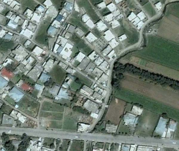
Imagery taken on June 15, 2005
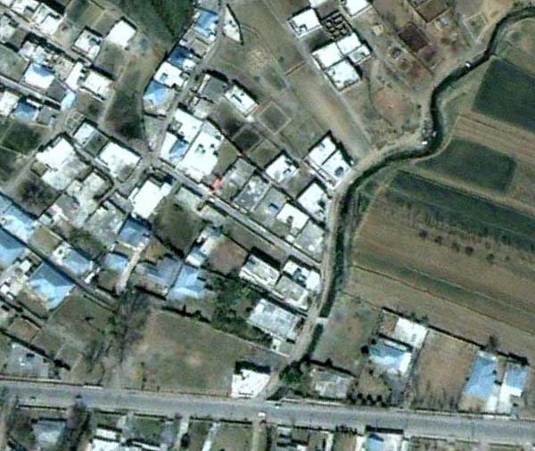
Imagery taken on March 23, 2001
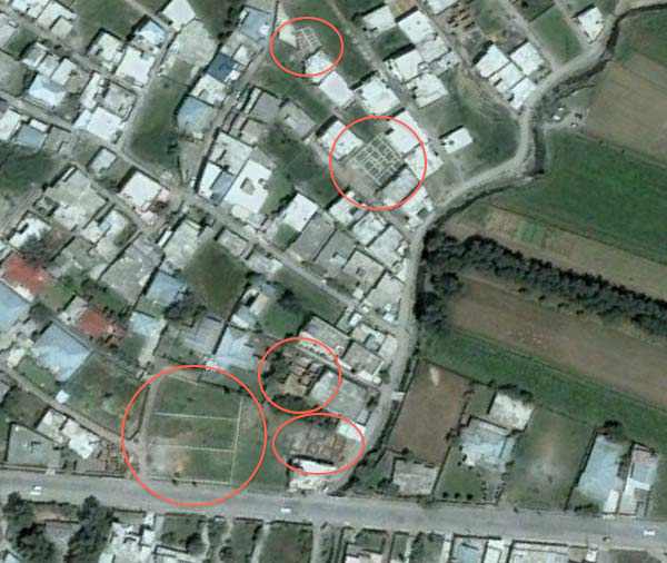
Construction ongoing on June 15, 2005
Of course, it is possible that construction on the mansion began after June 15, 2005.
Finally, here is a Google Map I’ve made of the locations mentioned in this article:
View Osama Bin Laden’s mansion location.kmz in a larger map
And here it is as a downloadable KML file for Google Earth.
It’s possible that these locations are wrong. The easiest way to find the precise place would be to walk on over there and take a look, but failing that, I will keep this article updated with more accurate information as it becomes available.
UPDATE 9:53 UTC: Pakistan-based journalist Omar Waraich tweets that the location of the mansion, and where he is headed to, is Bilal colony/town in Abbottabad. On Google Maps there is a marker tagged “Bilal Mosque” which corresponds perfectly with the screenshots of Google Earth above. In other words, there is reason to be more confident that the above locations are correct.
UPDATE 13:29 UTC: Here are screen grabs from Al Jazeera of the compound:

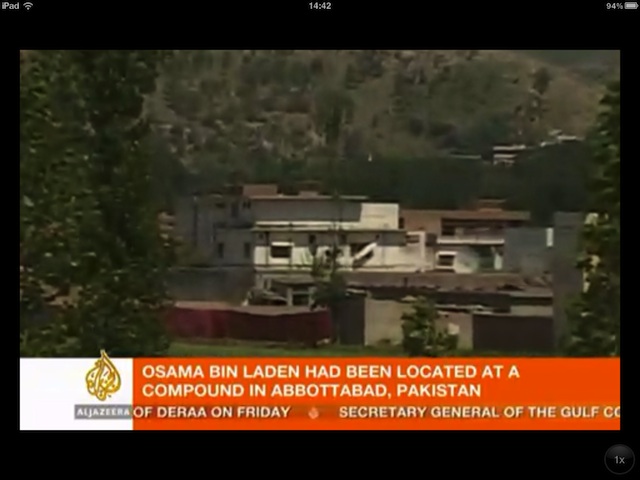
As you can see from the wide shot, the compound (not so much a “mansion” in terms of opulence”) faces the edge of an area with fields. Zooming in, we can see a section of red tarpaulin erected to hide ongoing investigatory activity. The mountainscape behind the compound can be reconstructed in Google Earth from the Bilal Town location pinpointed above. In other words, this is more evidence that Bin Laden’s compound is in the above location, most likely on the dirt road that runs along the creek visible in the Google Earth screenshots.
UPDATE 13:51 UTC: Here’s a screengrab of Al Jazeera’s map referred to above (via):
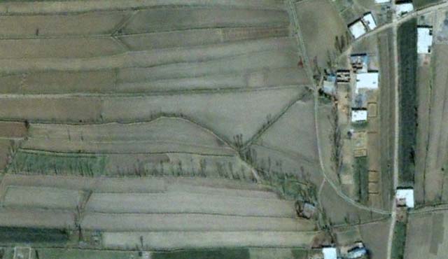
UPDATE 14:52 UTC: After a comment left by Dave (below), I took another look further to the west east of Bilal Mosque to see if there was any prominent construction there in 2005, in an area that is less built up than in Bilal Town proper. And indeed, there is one conspicuous compound that sticks out, and which closely matches the video imagery above. Here is the view in Google Earth in 2001:
And here it is in 2005:
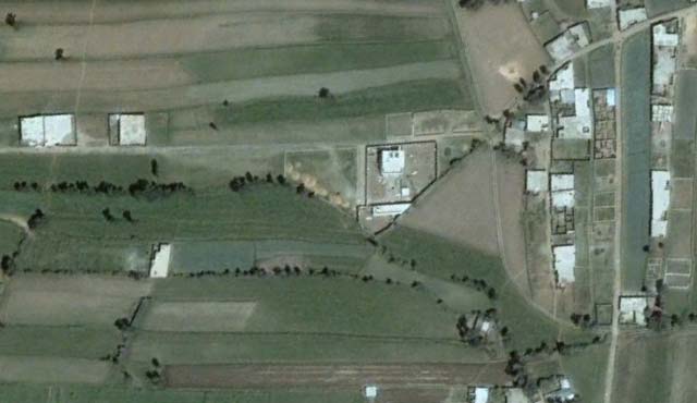
I think we have a very likely candidate here. (I’ve updated the map and added the location to the Google Earth KML file.)
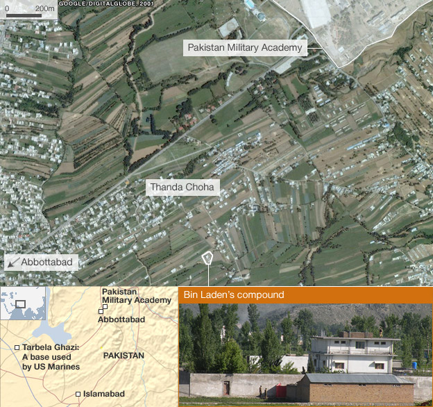
UPDATE 15:13 UTC: Published a few minutes ago, this new story by the BBC all but confirms that this compound is indeed the correct location, with a highly detailed map:
Thank you for playing everyone. We have a winner:
View Osama Bin Laden’s mansion location.kmz in a larger map
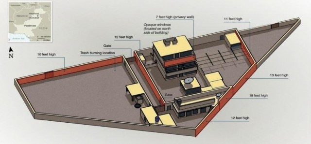
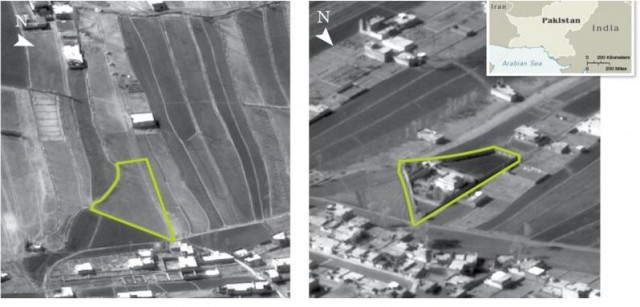
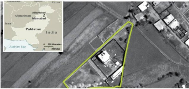
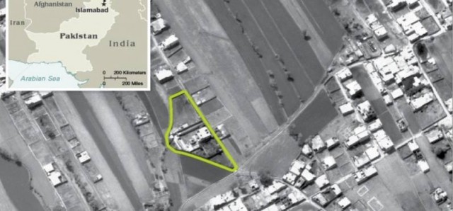
UPDATE 16:22 UTC: The CIA Pentagon releases aerial imagery confirming that this is indeed the location, as reported by the National Journal: (Click to enlarge. PDF of originals)
links for 2011-04-26
-
Just goes to show how much presentation can effect perception in maps.
Google Earth Builder: A potential solution to the map censorship conundrum in China, India
Google Earth Builder, announced and previewed at this year’s Where 2.0, will — among other things — let government agencies publish their own maps and satellite imagery to the public, scalably, using the same cloud-y infrastructure that underpins Google Earth and Maps. That’s different from the existing Google Earth Enterprise product, where Google provides the software but not the servers.
What interests me most about Google Earth Builder is that it has the potential to release Google from a conundrum it currently faces when delivering maps internationally: Some of the world’s more overbearing governments impose onerous constraints on locally served maps — such as in China and India, both of which demand the drawing of incompatible borders and the removal of sensitive sites from maps. (This is why Google maintains separate sets of data for these locally-served maps.) China also insists that Google take responsibility for censoring any user-generated content it might want to publish. (As a result, Google’s local Chinese maps don’t publish user-generated content.)
With Google Earth Builder, Google can now play host to virtual globes without also being the publisher, thus relinquishing responsibility for the content. This allows for some interesting new arrangements.
While some governments have been happy to give Google their mapping and imagery data for use in Google Maps and Earth, viewing it as a free distribution model for a public good, other governments have chosen to view Google’s free maps as a threat: perhaps they balk at the free, advertising-driven nature of Google Maps, or the fact that Google’s maps are a for-profit pursuit by a private corporation. A more creative argument put forward in 2006 by France’s then-president Jacques Chirac states that the ability to serve online maps is a strategic technology for a state to have:
[…] Chirac stressed the need for France to have such a site […] saying the state had to be at the cutting edge of modern technology.
And indeed, France was the first of several countries to build a “Google Earth killer”. Géoportail, released in 2006, was followed in 2008 by India’s Bhuvan and in 2010 by China’s TianDitu. TianDitu’s virtual globe is homegrown, but with satellite imagery purchased from Digital Globe. Géoportail and Bhuvan, however, are both implementations of a mapping platform produced by Skyline, an American company. (So much for French strategic thinking.)
What all three geoportals have in common is that they are hardly best of breed, and certainly no “killers” of anything: Their 3D visualizations require Windows-only browser plugins, navigation is often unwieldy, and as launch difficulties betrayed for all these sites, scaling up is a big problem.
Google Earth Builder solves all these problems. Now a government can publish their own branded geoportal via Google’s infrastructure, using as much (or as little) of Google’s content it approves of and adding the rest. Google makes its money as a contracted service provider instead of through advertising, while the end user of the resulting product gets free maps that are inoffensive to the country footing the bill. (It’s not clear to me whether Google’s terms would allow somebody to sell their own ads against the maps to defray costs, or whether competitors like China’s Baidu could use Google Earth Builder.)
Once Google Earth Builder is available, Google has a new chip to bring to the bargaining table when dealing with regulatory issues surrounding maps in India and China (and potentially elsewhere). One thing that the chapter on China in Steven Levy’s recent book In the Plex confirms is the extent to which Google’s entry into and subsequent exit from the Chinese search market was fraught with a moral ambivalence that eventually outargued any profit motive. This ambivalence has not yet been resolved in Google’s China-facing mapping product, ditu.google.cn, which continues to toe the (border)line as China sees it. An ethical solution to the Google Maps conundrum in China, then, might involve shutting down ditu.google.com, but inviting the government or any number of private Chinese internet startups to adopt Google Earth Builder as their mapping platform, letting them instead engage in the arduous vetting process that precedes the granting of a web mapping license in China (which, by the way, Google is still without (via). It’s not even clear that Google has applied, which could mean that this scenario is very much in the process of unfolding.) Surely, some Chinese ex-Googlers will be interested in providing a technically superior albeit politically censored mapping service to the Chinese intranet…
The upshot: Google finds a way to get paid in an enormous and growing market, and at the same time is making sure that censorship invokes a cost. There’s a certain genius in that arrangement.
(A technical note: Google Earth Builder only seems to work with the Google Earth standalone client when accounts are used to regulate access (hence it would need Google Earth Pro or Enterprise). It therefore seems likely that any public-facing 3D maps made with Google Earth Builder will be a delivered via the browser and the Google Earth plugin.)
