Iran missile base post-explosion imagery, now hi-res in Google Earth

On November 12, a powerful explosion ripped through an Iranian missile base on the outskirts of the town of Bīdgeneh, 40 km west of Tehran. As the Guardian reported soon after, among the dead at the base was the architect of Iran’s missile program, Major General Hassan Moghaddam. There has been heavy media speculation the explosion might have been the result of a covert operation by Israel’s Mossad.

Post-explosion satellite imagery has now become available that shows the extent of the destruction. Commissioned by the Institute for Science and International Security (ISIS), the imagery was taken on November 22, 2011. ISIS Senior Research Analyst Paul Brannan has published the annotated image along with the most recent available imagery from before the explosion, taken September 9, 2011. He adds:

ISIS learned that the blast occurred as Iran had achieved a major milestone in the development of a new missile. Iran was apparently performing a volatile procedure involving a missile engine at the site when the blast occurred.

You can’t tell from the imagery if sabotage caused the explosion, but you can tell the damage was extensive, wiping out most structures at the base. The NYT elicits more commentary from Paul Brannan in an interview.

Because ISIS’s web post and accompanying PDF used lower-resolution versions of the Nov 22 image, I asked ISIS for the original high-resolution image, to overlay on Google Earth. The September 9 imagery is already in Google Earth’s base layer, so it was just a matter of overlaying the one new image. Here is the resulting KMZ file, containing the high-resolution original, ready to open in Google Earth.
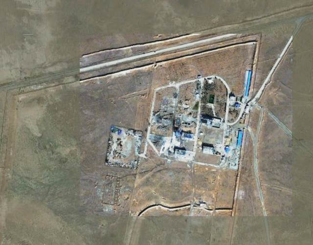
In Google Earth 6 and above, remember to click on the opacity button in the sidebar and then play with the opacity slider to switch between the before- and after- imagery. For reference, the sports court at the base is 30×15 meters, about the size of a basketball court.

P.S. On November 28, an new explosion ripped through what appears to be a uranium conversion plant near Isfahan, rattling windows in the city. Speculation is mounting (some based on intelligence sources) that Iran’s nuclear and missile programs are being systematically sabotaged or attacked. In 2010, the Stuxnet worm caused heavy damage to the uranium enrichment facility at Natanz.

In Slovenia, photography gets regulatory scrutiny

Over at Dliberation, I’ve reported on a story with a geolocation twist likely of interest to Ogle Earth readers:

In an unfortunate bout of regulatory innovation in Slovenia, the information commissioner there has decided that panoramic photography benefits from less legal protection than conventional photography because she reckons panoramas make it is easy to tell where the photograph was taken, and when, thus compromising the data rights of the people in the shot. She argues this, apparently unaware that all modern digital photography comes with EXIF time stamps which sites such as Flickr will automatically share, while many smart phone camera apps will attach their location to photos published to Twitter or Facebook. Photographs of landmarks also situate individuals at a certain place at a certain time. The commissioner may have unwittingly condemned all such photography to Street-Viewesque blurring requirements — at least if she is consistent in her logic.

I “blame” Google for this:

[This is] a case study of how Google, by voluntarily implementing facial blurring in its relatively new but hugely popular Street View automated 360-degree panoramas, created norms in the minds of regulators that they are now eager to set in stone legally.

Because Street View is so popular, it is quite possibly the only kind of immersive panorama that most people have seen. I believe this has altered popular expectations regarding the blurring of individual faces, which led to the commissioner decreeing that all panoramas not depicting a news-worthy event need to be blurred. Ironically, Google Street View isn’t even available in Slovenia:

That’s because Slovenia said it would require Google to keep the raw Street View images in Slovenia until they were blurred — no unblurred images were allowed to leave the country. Because the blurring makes use of Google’s servers, none of which are in Slovenia, Google respectfully declined to add Slovenia to its Street View program.

Read the whole article over at Dliberation.org.

Announcing Dliberation.org

In case you wonder what else I get up to, in terms of my interests: I’ve started Dliberation.org, a blog about the global social and political impact of digital networks. What Ogle Earth is to digital atlases, Dliberation is to digital networks — so yes, it is a lot less niched, but in line with how my interests have developed these past few years. Ogle Earth continues to be the place where I report on how Google Earth affects science and society; for a broader look at Internet regulation, censorship, surveillance, activism and cybercrime, visit Dliberation.org. Here’s the inaugural post, about a new research center for the Internet and Society, situated in Berlin and funded by Google. I hope you enjoy reading it as much as I will enjoy writing it.

Hunting illegal mining in Goa

There is a juicy scandal unfolding in India’s smallest and richest state, Goa, where the State Assembly’s Public Accounts Committee (PAC) has prepared a report indicting ruling Congress Party politicians for benefiting from illegal mining in the state. Illegal mining is estimated (by the Hindustan Times) to have cost Goa over USD 600 million over the past five years in lost tax revenues, turning this into a whopper of a story.

Reporters are having a field day with the clumsy ways in which local Congress Party bigwigs have maneuvered to derail the report. Congress Party members on the PAC committee refused to sign the report, but that didn’t deter the chairman of the committee, Manohar Parrikar, from submitting the report to the State Assembly. The (Congress-affiliated) speaker of the Assembly, Pratapsingh Rane, then refused to table the report, on account that it is “merely a draft”:

On October 8 Rane sacked Parrikar, who also happens to be the leader of the opposition, from his role as chairman of the PAC committee. Parrikar then vowed to release the findings to the public, “using government documents and records that are in the public domain,” reports the Hindustan Times.

Part of those public domain records are from Google Earth, The Economic Times reports:

According to highly placed sources, the PAC has based its findings against [Congress Party leader Dinar] Tarcar on the satellite images procured by the Google [Earth] tool.

The mine operated by Tarcar through Power of Attorney at Temebocheo Dongor in rural Goa (survey number 59/51) has been found to have extracted several million tons of ore. […]

“The Google pictures of 2003 clearly show that the area was a virgin land and it is not possible to agree with any fallacious contention that several million tons of ore dump accumulated has been done on account of earlier dumps accumulation,” the report mentioned.

India’s national Directorate of Mines and Geology has now also taken an interest in the mine, ordering it to immediately cease production until it is investigated. An article by Goa’s Herald spells it out for us:

Tarcar has cheated the government by avoiding huge amounts of export duty by under-invoicing of his exports.

When presented with evidence of massive ore dumps that could not have been produced within quota, his mining company contended that these were from earlier activities. Google Earth’s imagery from 2003 effectively catches the company in a lie.

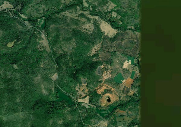
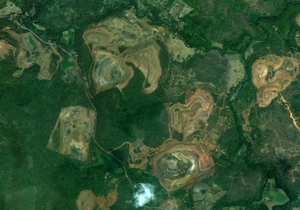
So: Where is Temebocheo Dongor in Goa, and is there an mine there that didn’t exist in 2003?

Browsing Goa’s hinterland with Google Earth, you’ll find it riddled with open-pit mines — mining is the second largest industry in Goa, after tourism.

Two pieces of information allow us to pinpoint a strong candidate for the mine in question. The first is that we know there has to be imagery of the mine from 2003 in Google Earth. About two thirds of Goa satisfies that criteria.

The second piece of information comes from the Herald article, which points out that the mine is “at Caurem and Maina.”

Those places are easily found in Google Earth via search. Once there, turn on historical imagery, and voilà, here is the closest high-resolution imagery available from 2003, taken on Feb 10 of that year, showing virgin lands and an embryo of a mine:

Versus the current view, from March 27, 2011:

If you want to see the historical imagery yourself, here is the KML pointer to it in Google Earth. Or have a look for yourself in Google Maps:


View Larger Map

Absent verification on the ground, we can’t be 100% certain that this is the Temebocheo Dongor mine, but it sure looks to be a strong candidate.

Biannual Swedish media panic sets in as Google Earth continues to show Sweden’s “secrets”

In Sweden late last week, the story “broke” [translation], as it tends to do every few years, about how Sweden’s military secrets are visible in imagery on Google Earth and Maps, but not on its local competitors, Hitta.se and Eniro.se, amid general consternation from random interviewees.

The one big difference this time round is that Google Sweden’s own spokesman, Andreas Svenungsson, appears to join in, expressing what Swedish Radio describes as “self-criticism” when he says that “clearly, if it’s not supposed to be there [on the map] then we will take it away.”

It is possible that he was being diplomatic, knowing full well that Google is not required to censor imagery taken from space or which is already in the public domain. Much better, however, would have been to use the interview as a teachable moment, pointing out that just like any other country, Sweden has no sovereignty over space, but that it is welcome to censor its own aerial imagery before it is published by Sweden’s national GIS agency, Lantmäteriet. And that Google has no obligation to use Lantmäteriet’s imagery, though it currently does for large parts of the country.

This blog has long lambasted Lantmäteriet’s policy not just of censoring its maps, but of obfuscating the censorship, making it look as if “sensitive” locations are forests or fields instead of just pixellating them. Lantmäteriet was caught doing this with the National Defence Radio Establishment (FRA) HQ back in 2006 and more subtly in 2009. This kind of behavior undermines trust in all their maps and data, and is unbecoming an open society, especially when the information is easily available via other channels. (The Dutch, for example, openly pixellate.) There was a moment of hope earlier this year, when it looked like Lantmäteriet had moved on from these cold-war methods: It released what appears to be uncensored imagery of the FRA HQ, visible in Google Earth. It now looks like this was just sloppiness on their part.

Because Google’s spokesman doesn’t educate the reporter, Peter Andersson, much of his article is mired in confusion. The current panic is about the locations of the two main underground control centers for Sweden’s air force — one near Stockholm, and the other in the South of Sweden; both are well-known nationally. In Google Earth, the one outside Stockholm is visible, but not the one in the South. This happens to be because near Stockholm, Google’s current imagery consists of uncensored satellite imagery from DigitalGlobe; in the South, it uses censored imagery from Lantmäteriet. Andersson and his interviewees assume that because one of the locations is censored, both should be.

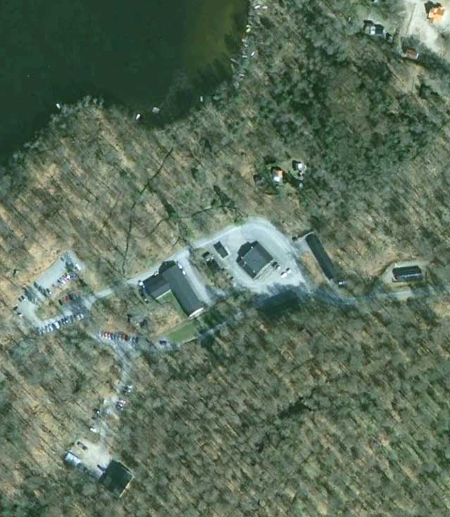
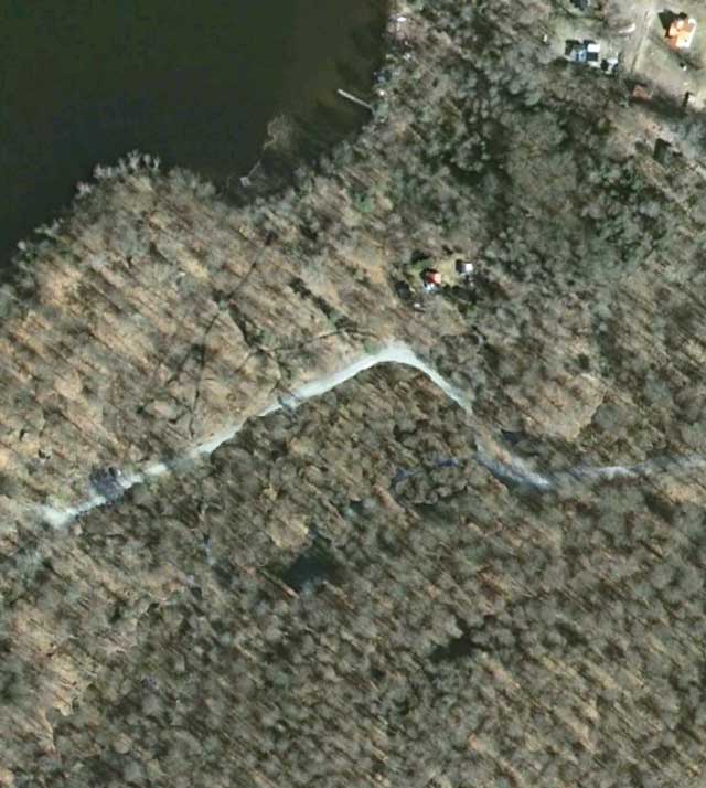
In fact, neither is: Even in the South, if you use Google Earth’s historical imagery tab, you can see two uncensored views of the control bunker area. It’s imagery dated from 2006 and 2009, and curiously also credited to Lantmäteriet, which obviously previously released it into the public domain without censorship. The location is very easy to find for anyone with basic Googling skills: Searching for the generic name for these underground centers, “stridsledningscentral”, leads to an article discussing how the nearby village of Hästveda depends on jobs at the control center in question. In Google Earth, the village is easily found. Then, by toggling between the current imagery and that from 2009 using Google Earth’s historical imagery panel, the Photoshopping by Lantmäteriet of the current imagery pops out immediately from the surrounding countryside, because it looks like buildings in 2009 have been replaced by virgin forest in 2010:


Hästveda stridsledningscentral in Google Earth, imagery from 2009.


Hästveda stridsledningscentral in Google Earth, imagery from 2010.

Try it yourself at this location in Google Earth (open downloaded KMZ file in Google Earth). Nobody should be in any doubt that keeping this kind of “secret” is pointless; the effort and intelligence required to discover it is so minimal as to render the term meaningless. The only people not in the know are those who don’t care.

(If you read Swedish, this post on Cornucopia? runs through how the various mapping services portray Sweden’s various “secret” locations.)

Iran set to launch Google Earth rival

Got GeoInt? flags a great story: Iran’s military is launching a Google Earth competitor, slated to go live later this week, according to the Iranian Mehr news agency and Tehran Times.

According to Brigadier-General Mohammad Hasan Nami, head of the armed forces’ geographical affairs organization, the web service will be called Basir, and is motivated to counter the “cultural aggression” of Google Earth/Maps against Islamic countries.

Google Earth is also accused of “distorting history”; while he doesn’t specifically refer to it, the Brigadier-General is no doubt referring to Google’s naming policy, which has resulted in the waters between Iran and Saudi Arabia to be labelled both Persian Gulf and Arabian Gulf. This has irritated the more literal-minded Iranians to no end, and resulted in both a protest from the Iranian foreign ministry and an online petition signed by 1,245,781 people last time I checked.

With Basir, Iran will now be able to call the Gulf anything it wants.

When asked to differentiate Basir from Google Earth, Brigadier-General names a qibla-finding tool — Which calculates the direction to Mecca, for prayer. Alas, due to the Google Maps API, qibla finders are now a dime a dozen.

But the most fantastical feature attributed to Basir by the Brigadier-General is the fact that “it can prevent certain websites such as the ‘Google Earth’ from gathering information about other countries.” I suspect something got lost in translation but I’ll have a guess at what he means: Now that Iranians will have access to a Google Earth/Maps substitute, it will be easier for the regime to justify blocking Google’s mapping services. After all, Google Earth is cultural aggression, so surely the next step is to block it.

Notes on Sweden’s high-resolution update in Google Earth

Just a quick heads up for Swedes and/or power users of Google Earth: I noticed via the latest KML change log for imagery in Google Earth that Sweden had gotten a significant new addition of high resolution imagery after years of being mostly in low-resolution purgatory.
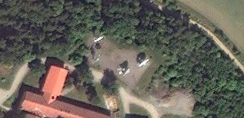
Just as with previous updates, most if not all of the imagery turns out to be from Sweden’s state GIS agency, Lantmäteriet.

There is good news and bad news to share with you.

The good news, overlooked by me since a previous smaller update in March 2011: Lantmäteriet appears to finally be restraining itself from censoring their datasets before release — the satellite dishes at the National Defence Radio Establishment (FRA) HQ, so clumsily airbrushed out of existence in a 2009 update, are now back:

Compare the current view to the view in 2009 and in 2007. If this is a trend, it is definitely in the right direction. It would be great to know if there was a policy decision behind it. Perhaps an actual journalist in Sweden will find out for us. (Or, Lantmäteriet reads this blog and decided to throw us a bone;-)

The bad news: Most if not all the imagery is labeled 1/1/2010, aka January 1 2010. This jars quite spectacularly with the new imagery’s summery scenes visible north of the Polar Circle — these images quite clearly were not taken on New Years Day.

So what happened? My bet is that Lantmäteriet either doesn’t have dates for a dataset taken piecemeal over a season (likely; it looks like it might be aerial imagery, reduced somewhat in resolution) or else it doesn’t want to give specific dates for privacy or financial reasons (unlikely). And so the metadata only tells us it is from 2010 — except that Google Earth can’t accommodate this level of all-too-human fuzziness, and so defaults to January 1.

Who cares? If you’re using Google Earth for research, it’s good to know that January 1 dates are probably bogus.