Google Earth 5.2 is out. Download it.
Over on Google’s official Lat-Long Blog, Peter Birch has the announcement and the overview of new features.
This latest release focuses on improving the visualization of user-generated data collected via the many GPS devices on the market today. GE 5.2 comes with two new powerful tools for analyzing your GPS-tracked trips: Tracks, and the visualization of elevation profiles and telematics:
Tracks: Previously, if you wanted to import GPS data into Google Earth you would either end up with a large collection of detailed points or else a much more compact linestring of the path that removed most of the point data. With GE 5.2, Google introduces an extension to KML called tracks, which aims to give you the best of both worlds. Briefly, tracks let you assign multiple time values to an object. This object can be a point, but can also be a complicated 3D model, say of a sailboat. Using tracks also lets GE 5.2 interpolate positions between the given time data.
The KML Reference page is now updated with a thorough explanation of the new <gx:Track> extension to KML. This is the place to start for all development of what will surely become the de facto means of visualizing GPS data in Google Earth. GE 5.2’s GPS importer creates these tracks automatically, but you can of course also roll your own.
Elevation profiles: In GE 5.2, you can right-click on any track or linestring in the Places sidebar to select “Show Elevation Profile”. A new panel appears at the bottom of the window graphing relevant data such as height and speed. If you select a range of data, you get information such as total distance, elevation changes, maximum slopes, average speeds and much more. It’s quite a sophisticated tool and best grasped simply by playing with it — Dan Barcay’s post on Google Lat-Long Blog provides some sample tracks to use.
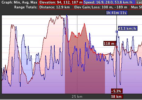
In addition, if you collect other data with your GPS device — such as heart-rate data — this too can be visualized if imported.
There is a third major new feature in GE 5.2:
Embedded browser: Now that Google Chrome is a mature cross-platform web browser, why not leverage it in Google Earth? GE 5.2 seamlessly integrates the web browser across all three platforms — PC. Mac and Linux. (Older Windows versions of GE inherited a IE-based split-screen browser that always felt tacked-on and which never gained much traction. This implementation is much better, and universal.)
If you click on a URL in GE 5.2, for example in a pop-up, you no longer leave the application and open your default browser — the 3D map is replaced by a full-window web browser pane. However, if you don’t like this intrusion of Chrome into your web surfing habits (or if you need your usual complement of shortcuts and plugins) you can turn off this default behavior in the preferences pane: Go to the General tab, and turn on “show web results in external browser”.
Embedding a web browser in Google Earth is a nice corollary to the embedding of Google Earth in web browsers via the Google Earth plugin, and it neatly illustrates the fact that the web browser and geobrowser are really just different sides of the same coin — highly evolved adaptations of data browsers. In the case of the geobrowser, that data’s most salient organizational aspect is its geographic location; For the web browser, location is not as important as the semantic neighborhood of the data, determined by links and URLs and such.
In may cases, however, the data straddles this divide, and could be usefully explored in either context. This is why I miss a split-window view in GE 5.2, where both geo- and web browser are visible simultaneously. Currently, the relationship between the geo- and web browser is one-way — actions in the geobrowser lead to the rendering of a URL location in the web browser. Why not have the geobrowser’s view change as the result of activity in the web browser? For example, visiting the web site of the Metropolitan Museum of Art in NYC could have the geobrowser component of GE 5.2 zoom in on the physical location and all the content that is nearby, and hence relevant.
NMEA: One more smaller feature, as per the release notes: GE 5.2 can now read NMEA files, as well as Garmin GDB, Garmin Training Center, and Ozi Explorer files. Previously, you needed an external application to convert these file formats into KML.
For the pros: Google Earth Pro gets a much-improved GIS importer that fully supports KML 2.2 and which lets you generate and handle GeoTIFFs, including their conversion to superoverlays. Pro also comes with additional default data layers for the US: Parcel data (useful for real estate), demographic data (down to the block level) and historical traffic data. The price for Google Earth Pro remains $400 per year. The release notes contain full information on the changes.
Finally, what’s missing? I’m still waiting for the cloud to hit Google Earth – so that my Places can be saved and synced and shared via the cloud, using my Google account.
About time, the elevation profile. Worldwind had it for ages!
It had to be said. :)
Hope all is well Stefan.
enjoying the great visualization capability with the new elevation profiles:
http://www.flickr.com/photos/gonzoearth/4701646651/
Smoothing needs to be added to the tracks. At least to my Garmin track. The vertical gain is higher than can be imagined. GE is taking all the random errors and calling it gain. Also shows up as slope. I seriously doubt I did a 52 percent grade this weekend while backcountry skiing. Another app shows a max of 44 percent which is more reasonable.
I’ve been hearing reports that GE 5.2 lost AppleScript support, but the AS Editor still shows there being a dictionary of Apple events to hook into. Does anyone know have an explanation?
Since the upgrade GE Pro has problems with our proxy. We can’t access the Elevation Profile, Embedded browser, Photo access (Panoramio), Real estate data and other enhancements. When I use my cellular data card (without proxy), I get all the features. What servers are being accessed for these enhancements?
Also, any way to get a profile of just the path points instead of all the profile between points? We only want a profile of the elevation changes between points.
Unfortunately, GE 5.2 is so buggy that it refuses to install on my PC. And – looking at the user forum – I’m not the only one.