- Not sure if this is new, but the Utah Geological Survey (UGS) has a series of articles on the state’s geological features which you can also access via a KML file. I really learned something from the well-written, highly informative content presented in nice-looking popups.
And it turns out there really is a Big Rock Candy Mountain! I thought it was just a depression era hobo song.
- Aubrey Falconer writes:
I just released a network link for my classifieds site, Safarri.com, that gathers classifieds listings from Google Base, Oodle (and soon Vast), matches them against any set of filters you specify, and then overlays them on Google Earth as you are flying around!
It is perfect for real estate, but is also fun for lots of other things like boats and cars as well. As far as I know it is the first filterable streaming classifieds overlay for Earth, and it has lots of nice features like one step setup, server side geocoding for a faster user experience, multiple ad providers, streamlined item “boxes”, etc.
- Voozici.com is a new user-generated restaurant, bar and shopping review site for France. All the places are geolocated on Google Maps, but also on a network link, which lets you browse by category (and that’s quite useful). This doesn’t work for Macs just yet, only PCs. (Via Batteries Not Included)
- Favorite quirky mapping site Strange Maps celebrates a milestone of sorts. Congrats.
Yearly Archives: 2007
For Sweden, Google Earth => Eniro.se
For some regions of Earth, there is more higher resolution imagery provided locally for free than what Google Earth can provide. Sweden is one example — here Eniro.se provides unsurpassed resolution (and gorgeous design to boot.)
That why this network link by Perifer.se‘s Anders Fajerson comes in so useful. Whenever you are looking at Sweden in Google Earth, click on the network link to see the same view on Eniro.se. For example:
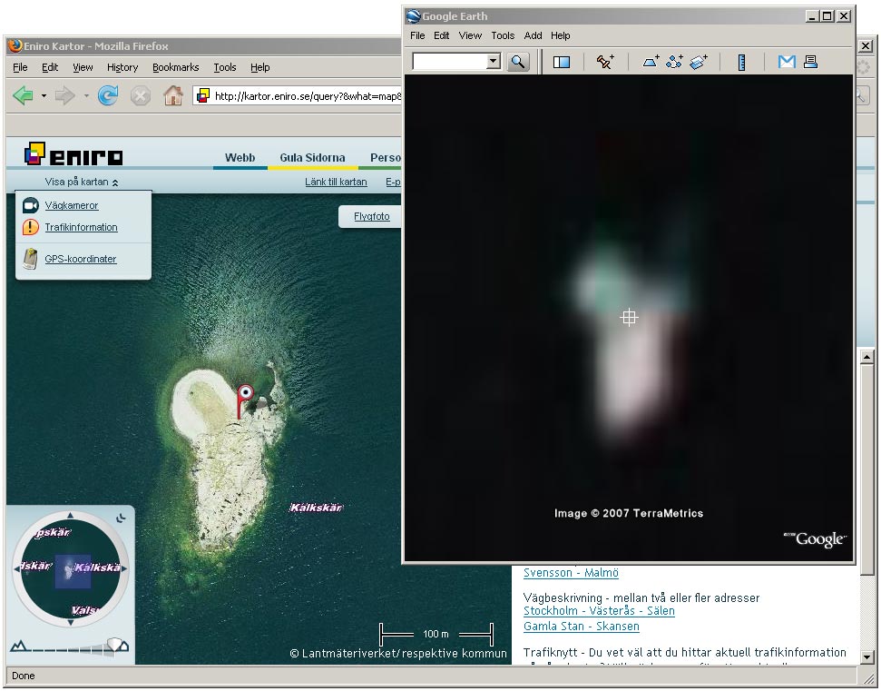
Click on the image to see a larger version. Here’s the permalink to Eniro’s view.
One caveat: The imagery Eniro uses is from a Swedish government agency, Lantmäteriverket, which is a known obfuscator of its own censorship. (At least I can vouch for the island pictured above. I kayaked to it last summer:-)
[Update 21:43 UTC: The network link works for Denmark as well.]
Ogle Earth notes
A perfect storm has conspired against blogging here these past few days: Intercontinental travel (I’m back in Sweden for a week), rapids in the pace at work, and an unstable Mac — if you’re going to use the Mac’s FileVault hard disk encryption feature, whatever you do don’t crash the machine. I know that’s a challenge, but it’s one I’m quite capable of rising to. Looks like a complete reinstall lies ahead this weekend. Argh. Better to just use Yojimbo and Knox in the future — I’ve never had problems with those. (The silver lining to running an Intel Mac: My Windows partition still works!)
(Also: An apology to the makers of the Berlin network link team for wondering aloud snarkily why it still won’t work on the Mac. It’s my Mac it won’t work on. Other Macs have no problems.) I’ve just figured out what’s wrong: The server hosting the network link only recognizes Google Earth Free for Mac, not Google Earth Pro for Mac. I use the latter, but have both installed. Switching to the free version solved the problem. What’s happening here, I’m almost certain, is that the server only responds to specific UserAgent names, and Google Earth Pro isn’t on that list.
The past few days were news-filled, of course. The amount of news worth reporting is clearly inversely proportional to my ability to report it (Stefan’s law?:-). I should be catching up shortly.
GeoMapLookup get KML support
GeoMapLookup, a very slick web 2.0-ish geolocator for IP addresses, has now added a link to Google Earth for every result. A nice touch: having the link in the popup. A very nice touch: Each IP lookup gets its own permalink. Me, I’m blogging this from here right now (and here is the permalink for the KML).
One possible use of all this permalinking goodness: Tweaking the templates in your CMS to show where commenters are coming from: Here’s how to do it for WordPress. (Via Cinnamon thoughts)
Censorship of India in Google Earth? Still no decision
India’s The Economic Times revisits the ongoing saga regarding spots on Google Earth that the Indian government would like to see censored.
The short version: “We have not yet decided whether or not to blur some key sites,” according to Andrew McLaughlin, Google’s head of Global Public Policy (is that title a first for a company? How do you get that job?:-)
The longer version — says McLaughlin:
We take security concerns seriously but obscuring images will not help. We have never degraded image quality… The images available on Google Earth are also available for purchase from various satellite companies in market. The government needs to deal with this issue at the level of satellite companies because they are selling images to us… mapping services etc are available commercially… sometimes free of cost and sometimes for a price. If images damage security then they need to talk to satellite companies. Blurring needs to be done by satellite companies… targeting Google Earth will not fix the problem.
All true, but it does bear repeating that while technically “We have never degraded image quality” is not the same as replacing existing DigitalGlobe tiles wholesale with older versions (which is what was done in Iraq), the effect is certainly the same. Older is worse.
Finally, the article also reminds us of Indian President A P J Abdul Kalam’s call in April 2006 for “a new law to prevent foreign satellites from getting images of sensitive locations in India and make such attempts a cognizable offense,” despite the fact that country sovereignty does not extend into space, where these satellites are.
Links: Update for Vista; Panoramio hits 1 million photos
- Via Virtual Earth asks why the 3D features of Virtual Earth have been slow on the uptake with developers, but has the answer handy:
My personal opinion is the 3D has issues with being an ActiveX control that runs on Windows and IE only, it is not really web.
In fact as a developer, if I know I am only targeting the Windows platform then a browser is not going to provide the richest user experience. I would be better off building a Windows application.
It’s ironic (just a little) that Google, meanwhile, has a standalone application, though for three different platforms.
- Overlays of antique maps of Russian cities, by Valery Hronusov.
- There’s a new version of KMLer, the ArcGIS extension that lets you export and import KML, by Valery Hronusov.
- Got Vista? There’s an updated version of Google Earth for you to download. (Via Google Earth Blog).
- Panoramio now has 1 million georeferenced photos in its database. That was fast. There’s nothing quite like getting a default layer in Google Earth:-)
Analysing Google Earth client stats
Last week Frank Taylor linked to Barry Hunter’s Google Earth client version stats for the KML content that gets delivered from his server at nearby.co.uk.
Analysing the last week’s figures leads to some surprises — for example, take a look at the relative size of the different platforms: Linux has about 5% of all queries, Mac 19.5%, with Windows the rest. That is a much larger proportion of people using Mac and Linux versions of the client than what you find for generic web browsers on most web sites.
I can think of a couple of reasons why: There are more Macs at home, where people do their surfing, than at the office, where network administrators likely do not allow installations of Google Earth Free. Also, the average Mac tends to be newer and have a better graphics card, making Google Earth a more viable proposition. And Macs are popular in education, where Google Earth is a hit.
Looking at the figures for Google Earth Pro, just under 20% of all uses are with a Pro client. (Of course, this proportion is heavily dependent on the type of content available on a server.)
Finally, it looks like only about 4% of users are still using Google Earth version 3, though visitors to Nearby.co.uk are most likely to be savvy users, and such users tend to be aggressive updaters.
Conclusions? These, I think:
- There is no need to continue supporting version 3 of Google Earth. Almost everybody has version 4.
- If you make network links or API-based extensions that only work with the Windows version of Google Earth, do realize you are not reaching one in four Google Earth users.
Talking of PC-only contents, why is it that the Berlin network link still doesn’t work on a Mac after almost two weeks? Weren’t they going to fix that? [Update: Um, it seems to be working for some people on their Macs, though not others. Feedback is welcome.]
(Caveat: The above analysis is just an interpolation from one server’s results. If anyone else has such stats, I’d love to hear if they are similar.)