AGI makes Satellite Tool Kit, an astrodynamics application for designing, visualizing and analyzing air and space flight. It does a lot of heavy lifting for government agencies, the military, and civilian aircraft manufacturers.
One use is the planning of flying unmanned flying drone (UAV) missions and the analysis of gathered data. Not everyone has an STK system installed, however, so now there is a utility that exports that data (and stuff like it) to KML. It’s shown in action in this YouTube video:
Watch it even if just for the eye-candy of seeing how STK’s virtual globe works. Can’t wait for this kind of augmented reality prowess to show up in Google Earth:-) Okay, maybe we’ll have to wait a couple of years.
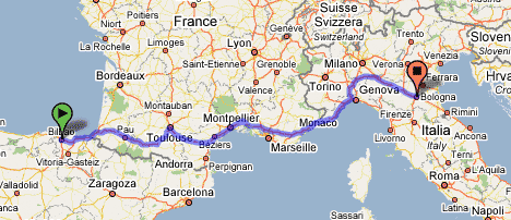
Google Maps just got a jaw-droppingly impressive upgrade to its directions functionality. Just watch the YouTube video already:
You have to play with it to believe it. And it works in Europe too, across countries:
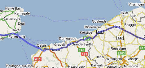
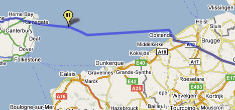
And it handles ferries seamlessly:
I have no idea how the algorithm for finding routes does its work so fast, or how address labels get to be displayed on the fly as you drag a destination around, but this bit of AJAX programming is simultaneously technically stunning, useful, and easy to use.
This morning, the state comptroller, Thomas P. DiNapoli, held a news conference in Midtown Manhattan to urge Internet-based mapping services to consult with law enforcement authorities — and well, to just be responsible — in deciding what to put on the Web. Citing Google Earth among other services, he said he was worried that too much information might compromise counterterrorism efforts.
Right. Because terrorists are too stupid to drive cars and take pictures themselves. (Some of the comments attached to the article are priceless.)
As you perhaps know, the residence of US Vice President Dick Cheney — the US Naval Observatory — is pixellated in Google Earth/Maps (and Microsoft Virtual Earth), and has been since the application launched. The White House and the Capitol are crystal clear, so why not Cheney’s residence? Is it a conspiracy?
Probably not. This issue was first raised by Maureen Dowd back in 2005 and deemed then to most likely be imagery processed along outdated guidelines. In a similar case, Google upgraded imagery of the White House when the existing view was shown to be doctored. In other words, Google has likely just never gotten round to finding a better un-pixellated view of Cheney’s home — so it would be unfair to blame Cheney for the state of his home in Google Earth, at least without some kind of evidence he’s behind the pixellation.
That doesn’t stop Jon Stewart at the daily Show from doing this, however:
At the very least, it’s more evidence of Google Earth’s grip on mainstream consciousness.
Webware has a sneak preview of Earthmine, a georeferenced urban imagery system that aims to outdo Google’s Street View with clearer, higher-vantage imagery and (it is claimed) 3D data gathering abilities. ETA is later this summer. (Thanks Andy!)
As the online version’s headline implies (or possibly, overstates to the point of self-parody), it’s about how Google Maps and Google Earth are altering the way people relate to geography. Perhaps more interestingly, it’s about how thousands of people have taken the tools made by Google and other companies to become their own mapmakers.
It’s an informed and worthwhile read.
Feed Validator’s KML support has now been officially announced on the Google Maps API Blog.
Google is opening its first office in Sub-Saharan Africa, in Kenya. Jonathan Thompson of Humanlink flags a really interesting tidbit in an interview by AllAfrica with Google’s new site lead, Joseph Mucheru:
Q: So what’s Google want to do?
Initially there will be three big things. Firstly, we want to optimise the use of Google applications in the region. We already have a lot of customers in the region but further development of the market is hindered by the absence of an international cable offering cheap bandwidth. Google understands that this is an impediment and is willing to go to the extent of buying international bandwidth [so] that locals don’t have to pay the current considerable premium they are.
The second thing they want to develop is their Maps product to make sure it has local information that is searchable and useful.
The third thing is using Google advertising in ways that can help monetize local content. Lots of people have done local content but most times it’s flopped. We hope to show that there’s a way of doing advertising that can support content. If we can do this, it will generate jobs and work.
The info about Google Maps is welcome but not unexpected. The bit about subsidizing access to the web (and thus Google) in Africa is a fascinating idea, and not one I’ve seen mentioned elsewhere. Writes Jonathan:
These developments has serious implications for aid workers who are based in the region. Kenya has long been the hub for South Sudan, Somalia and to some extent Uganda and Ethiopia. Let’s hope they cover South Sudan first. Not sure how they’ll handle the bandwidth issue. With the Google Earth Pro Grants program and increased capacity we’re looking at some substantive changes for the aid community.
Michael Kosowsky, who’s behind HeyWhatsThat (the website for generating panoramas from digital elevation models that I gushed about a few months ago) was invited to give a Tech Talk at the Googleplex a month ago. Michael writes:
It’s the best summary I’ve got of what HeyWhatsThat is and how it got to be that way. If you aren’t inclined to watch the whole thing, I think the Andrew Wiles joke at the very beginning is pretty good.
Here is the Google Video:
What more news? This post pretty much write itself: Michael says:
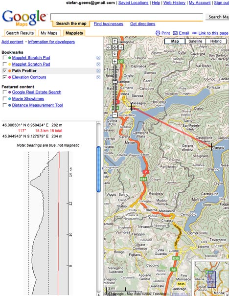
Have just spent a few weeks doing what we call “refactoring,” which in this case means rewriting almost every single line of code with absolutely no change in functionality. Well, not quite; contours are now available at every zoom level at the main site and the Path Profiler (you used to have to zoom in fairly close to get the ‘Contours’ button to appear; now you can see contours while viewing the entire world) and profiles that traverse large portions of the globe will be drawn as quickly as short ones.
I’ve also created a pair of “Mapplets” for Google Maps: Elevation Contours and Path Profiler. To see what I’m talking about, start at