- The next weird thing to come out of China: Huge lines in the desert. As AbFab’s Patsy would say, “Yeah, but is it art, Eddie?” (Via Google Earth Hacks)
- Alan Glennon plays with EditGrid — he uses the fact that you can reference individual cells via HTML to produce a proof-of-concept PHP script that extracts data from EditGrid cells and turns it into a KML file. Love it.
- AutoDesk does a bundle with Google Earth Pro. All Points Blog has good commentary, and comments.
- ViaTime: “Simulating the world of air travel for children using Google Earth.” Seems to have been around for months, but it’s new to me. Let’s you — ahem, children — create fantasy airlines with mock routes and then watch your flights, teaching you about great circle distances in the process. By Matt Paskus at Western Washington University’s department of geography.
Monthly Archives: August 2006
Short news: Drugs, Dutch politics and disaster
- Truly Frustrating: Truthbox has a post up with extensive images depicting overlays on Google Earth pinpointing poppy fields in Afghanistan and Colombia, but then doesn’t provide the files themselves so that we can have a go. Google Earth is interactive, people — it’s not a movie prop. [Update 2006-08-22: KML files are now added (see comments).]
- In the Netherlands, Groningen city council members belonging to the Dutch liberal party VVD are demanding that Google Earth depict high resolution images of their town. “Every corner of the world is visible, and yet Groningen is still a grey smudge and that just not allowed,” says the local VVD leader. He feels the city council should make existing digital imagery available to Google ASAP. His reasoning: It’s a way for hotels and camping grounds to present themselves to a wider public very cheaply.
- InformationWeek reports on Strong Angel III, a major disaster response exercise taking place in San Diego this week. Among the many tools at the disposal of first responders:
A disaster scene mash-up based on the open source Sahana disaster management software, created by Sri Lankan programmer Chamindra de Silva. Sahana can be used to establish missing person registries, coordinate relief efforts among groups, request support, and keep track of victims in shelters. The combination of Google Earth with Sahana will create a detailed visual image of a disaster area. Google plans to work with Microsoft to ensure that the modified Sahana works with Microsoft’s Virtual Earth service.
New Gombe chimp blog leads the pack for science outreach
The Jane Goodall Institute’s Gombe Chimp Blog has gone live with a major renovation. It now makes full use of Google Earth to explore Gombe National Park and the stories that take place there. Start with the latest entry to see how. There is a ton of added information that can be overlaid on top of the high resolution imagery of northwestern Tanzania — archives, first of all, but also local landmarks, chimp bios (with links to videos), watersheds, human settlements, trails, park boundaries…
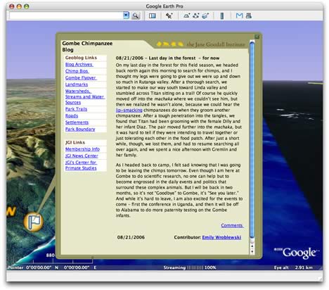
But what’s really innovative is how we’re asked to navigate this content. The popup window is turned into what amounts to a traditional web page (albeit using tables, as CSS is not available) with a column of links that upload further KML. This allows you to avoid the unwieldy Layers pane, in most cases.
All this turns the Gombe Chimp Blog into an instant favorite for science outreach. It also pushes Google Earth’s HTML rendering to the limit — it sure would be nice to be able to generate W3C-compliant rendering of CSS and XHTML inside Google Earth popups in the future. I, for one, would also like to see video depicted inside popups. It’s a natural thing to expect, from a user-interface perspective.
Kudos to Bryce Tugwell, BTW, for concocting all this. He adds that there is more enhanced data on the way. Hopefully, we’ll soon also get a network link we can subscribe to.
Businesses: Mind your rooftop manners
Families in a new housing estate in North Salt Lake, Utah, are unsure about the presence of Stericycle, an industrial waste recycler, in their midst, reports Deseret News. Google Earth plays a supporting role in the proceedings:
Though Folgmann is still trying to decide where to send her children to school, she said she’s concerned about the black soot that adorns the top of the incinerator.
After she read the news article [about Stericycle], her 12-year-old son, Drew, used Google Earth to look at incinerator sites around Utah. A black circle sits atop Stericycle’s facility but not on top of the Davis County burn plant or on top of the Deseret Chemical Depot, which incinerates chemical and neurological weapons.
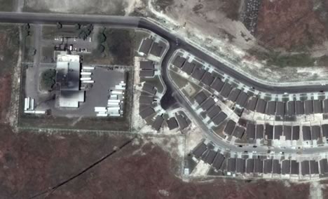
Though the state says there is nothing to worry about, her son may be onto something. Here is a KMZ file with Stericycle’s facility and the nearby housing estate marked. The facility looks pretty soot-ridden indeed, though the one caveat on this amateur sleuthing is that it is hard to ascertain when the image was taken — DigitalGlobe’s metadata is noncommittal on the matter.
Some further meta-commentary: 1) Why doesn’t Deseret News provide us with the placemarks? This should be part of the requirements of the beat, these days. 2) If you’re a business, can you still afford to neglect your rooftop’s aesthetics? Sure, not everybody needs to paint roofs in IKEA colors or with Target targets, but filthy rooftops will now be noticed, it seems.
Short news: iPhotoToGoogleEarth; Road Sign Math
- iPhotoToGoogleEarth is out of beta. Writes author Craig Stanton, “No fancy new features just bug fixes that have been pointed out by a few users, like avoiding files which aren’t jpegs, and dealing with ones that have funny characters in their names.”
- As if out to prove that there is a blog for everything these days, Road Sign Math finds correlations between the numbers on road signs. Now, they also link the posts to the actual locations of the signs with KML.
- Associated Content latches on to the public’s growing realization that Google Earth makes a first-rate social spying tool, and pens What is Google Earth, and How Can it Be Used to Uncover Military Secrets?
- Import Cartography has some constructive criticism on Google’s regionator toolbox.
- If the case of Google Earth’s aging dataset for the Canary Islands still has you in its thrall, Global Voices has a post that samples a wide range of original commentary translated from Spanish. Was it a conspiracy? Nah…
- Of interest to Belgians: belgeoblog continues to post excellent local content — an overlay of an old map of the completely
destroyed“revamped” northern quarter (post in Dutch), and an overlay showing that King Leopold II was not just genocidal, he was also a real estate hog (post in Dutch).
GameSpy previews Flight Simulator X
GameSpy.com has a preview of Microsoft’s Flight Simulator X, out on October 2, 2006. I like what I’m hearing:
The demo began innocuously enough: on Firminger’s screen was a blue orb surrounded by a visible atmosphere, suspended in a void. Spaceship Earth, as recognizable by most of its inhabitants. Interestingly, what he had onscreen wasn’t a desktop image or a version of Google Earth; it was Flight Simulator X, rendering the planet, atmosphere, and stars in real-time. […]
Geographical details are much more visible: the ground resolutions are significantly improved over its predecessor’s, allowing for the rendering of roads and flora in significantly higher detail: to the tune of 6,000 trees per square kilometer. […]
Via Internet connection, Flight Simulator X will monitor 5,000 real-time weather feeds in order to more accurately render the game’s meteorological systems.
More where that came from. This is still clearly a flight simulator, and a game. The multiplayer options also turn this virtual globe into a world with one shared state (for participants). The big question is, how much of this technology will be turned into a geobrowser? Microsoft certainly didn’t buy Vexcel and GeoTango to make a better 3D game.
Short news: Google Treks; Bahrain PR
- Google Earth CTO Michael Jones is manning a reconstruction of Starship Enterprise’s bridge as part of a drive by Google to recruit engineers from among the ranks of Star Trek fans at a convention in Las Vegas, reports AFP. What’s on the Enterprise’s screens? Fittingly, it’s Google Earth.
- Sneaky: Google calls for feedback from Bahraini users, reports Gulf Daily News. Says a Google spokesman, while trying to stifle a grin at the good fortune of this PR coup:
We have heard conflicting reports about Google Earth access problems for our users in Bahrain and we are looking into these reports to determine the cause and welcome any input from our users there.
It’s safe to assume that by now pretty much everyone in Bahrain wants to try this Google Earth thing, whatever it is, to see what the fuss is about.
- Another virtual globe hits my radar screen: Eingana. Not sure about its chances, as it costs £10 and yet doesn’t have Google Earth’s specs. Short review.