UPDATE: Scroll to the end of the article to see the final confirmed location of the compound.
UPDATE 2: A new post: 2011 DigitalGlobe imagery of Bin Laden compound, now on Google Earth
UPDATE 3: More posts: GeoEye publishes post-raid satellite image of Bin Laden compound, In the Situation Room, aerial imagery of the Bin Laden compound.
Osama Bin Laden’s death first manifested itself as short news items on Pakistani news sites: “Copter crashes on Kakul road – Monitoring Desk“, and indeed, later we would hear that one of the helicopters used in the raid on Bin Laden’s compound was damaged and destroyed.
The repercussions of Bin Laden’s death are still uncertain, but this post will just concern itself with the location of this compound. Where exactly was it? Can we find it on Google Earth?
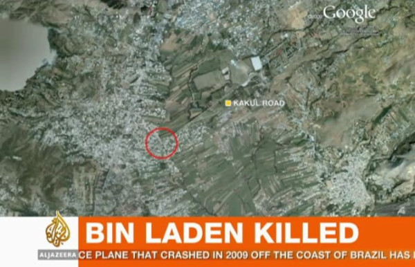
Al Jazeera English mentions “a mansion” surrounded by high walls, comprised of “boxes” with no windows. On a map of Abbottabad shown on their screen, Al Jazeera shows Kakul Road, and marks a specific location on that road, at the edge of some fields.
In a news story sourced to CBS/Associated Press, we get an eyewitness to tell us the following:
“I heard a thundering sound, followed by heavy firing. Then firing suddenly stopped. Then more thundering, then a big blast,” he said. “In the morning when we went out to see what happened, some helicopter wreckage was lying in an open field.”
He said the house was 100 yards away from the gate of the academy.
The New York Times reports that the mansion was “on the outskirts of the town’s center, set on an imposing hilltop and ringed by 12-foot-high concrete walls topped with barbed wire.” It goes on:
The property was valued at $1 million, but it had neither a telephone nor an Internet connection. Its residents were so concerned about security that they burned their trash rather putting it on the street for collection like their neighbors.
American officials believed that the compound, built in 2005, was designed for the specific purpose of hiding Bin Laden.
Is it possible to correlate these disparate clues? Not really. The NYT is most likely to be wrong as to the location — Al Jazeera footage shows a backdrop of flat fields near the compound, not a hilltop. Also, from the position marked by Al Jazeera on the map, the front gate of the military academy is around 2km away along the straight Kakul road, rather than the “100 meters” mentioned by the AP eyewitness.
I am inclined to give Al Jazeera the benefit of the doubt on this. They are the most likely to have people on the ground with the correct information, they are specific in their pinpointing of the location and their video footage supports their map.
But there is one further clue we can use. Google Earth’s high-resolution map of the area has imagery from June 15, 2005 — almost 6 years old. One set of older imagery is available — from March 23, 2001. If the NYT sources are correct on Bin Laden’s mansion being under construction in 2005 (and on this they are likely to be correct, as it sounds like a piece of information from an intelligence source) then we should be able to compare the 2001 imagery with the 2005 imagery, and look for any mansion-sized construction going on in 2005.
[Update May 3: Google today updated its base image layer to include imagery from Abbottabad taken on May 9, 2010 — just under a year ago. You can still see the imagery from 2005 (and 2001) by using the historical imagery time slider tool in Google Earth.]
And Indeed, in the specific region marked by Al Jazeera, there is construction underway in 2005. Below is the imagery in 2005, then in 2001, then in 2005 again with the construction marked.
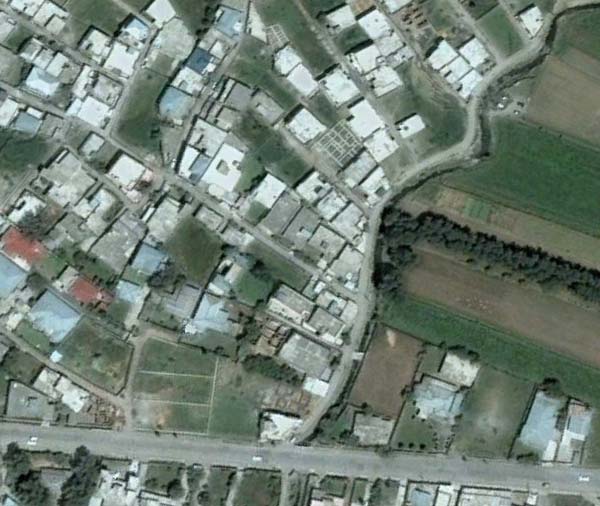
Imagery taken on June 15, 2005
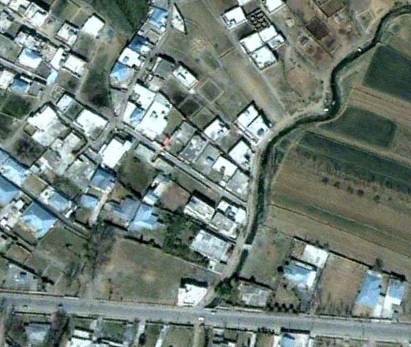
Imagery taken on March 23, 2001
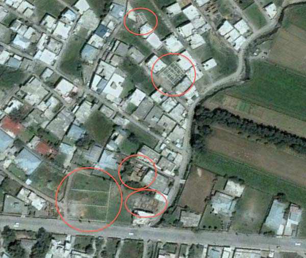
Construction ongoing on June 15, 2005
Of course, it is possible that construction on the mansion began after June 15, 2005.
Finally, here is a Google Map I’ve made of the locations mentioned in this article:
View Osama Bin Laden’s mansion location.kmz in a larger map
And here it is as a downloadable KML file for Google Earth.
It’s possible that these locations are wrong. The easiest way to find the precise place would be to walk on over there and take a look, but failing that, I will keep this article updated with more accurate information as it becomes available.
UPDATE 9:53 UTC: Pakistan-based journalist Omar Waraich tweets that the location of the mansion, and where he is headed to, is Bilal colony/town in Abbottabad. On Google Maps there is a marker tagged “Bilal Mosque” which corresponds perfectly with the screenshots of Google Earth above. In other words, there is reason to be more confident that the above locations are correct.
UPDATE 13:29 UTC: Here are screen grabs from Al Jazeera of the compound:
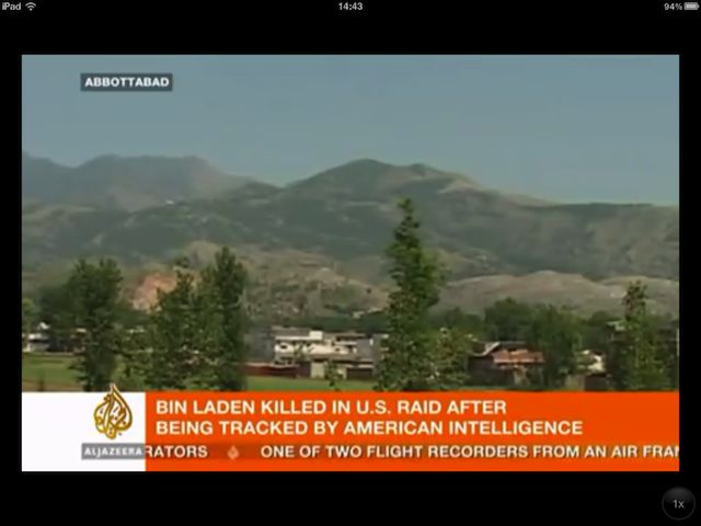
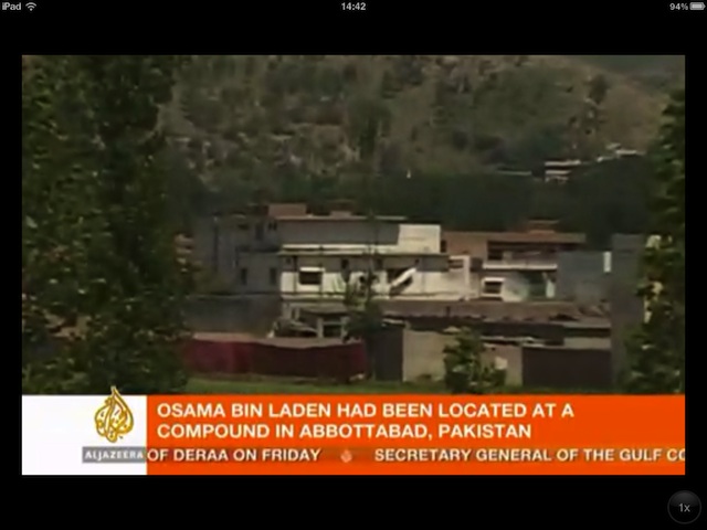
As you can see from the wide shot, the compound (not so much a “mansion” in terms of opulence”) faces the edge of an area with fields. Zooming in, we can see a section of red tarpaulin erected to hide ongoing investigatory activity. The mountainscape behind the compound can be reconstructed in Google Earth from the Bilal Town location pinpointed above. In other words, this is more evidence that Bin Laden’s compound is in the above location, most likely on the dirt road that runs along the creek visible in the Google Earth screenshots.
UPDATE 13:51 UTC: Here’s a screengrab of Al Jazeera’s map referred to above (via):
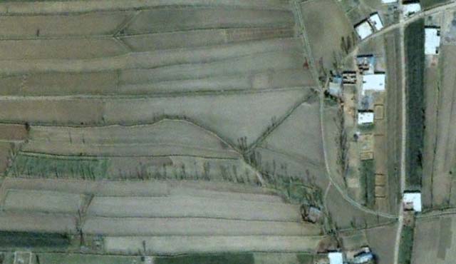
UPDATE 14:52 UTC: After a comment left by Dave (below), I took another look further to the west east of Bilal Mosque to see if there was any prominent construction there in 2005, in an area that is less built up than in Bilal Town proper. And indeed, there is one conspicuous compound that sticks out, and which closely matches the video imagery above. Here is the view in Google Earth in 2001:
And here it is in 2005:
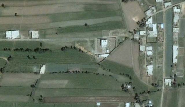
I think we have a very likely candidate here. (I’ve updated the map and added the location to the Google Earth KML file.)
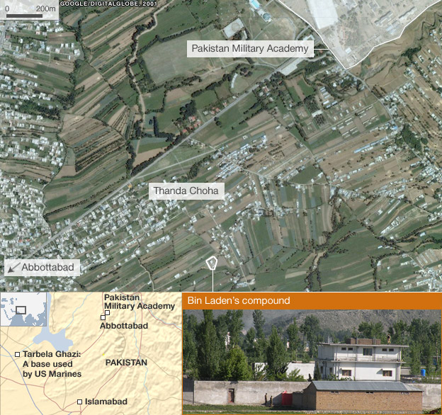
UPDATE 15:13 UTC: Published a few minutes ago, this new story by the BBC all but confirms that this compound is indeed the correct location, with a highly detailed map:
Thank you for playing everyone. We have a winner:
View Osama Bin Laden’s mansion location.kmz in a larger map
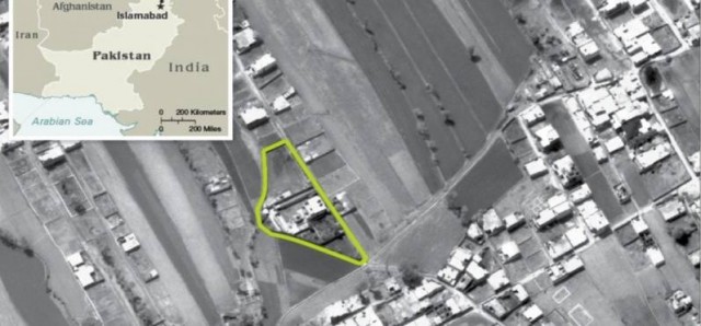
UPDATE 16:22 UTC: The CIA Pentagon releases aerial imagery confirming that this is indeed the location, as reported by the National Journal: (Click to enlarge. PDF of originals)
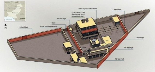
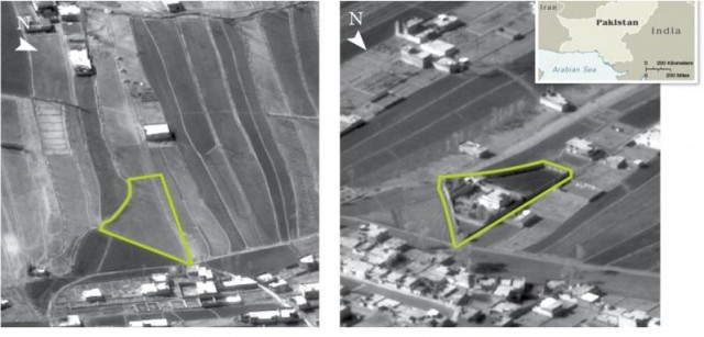
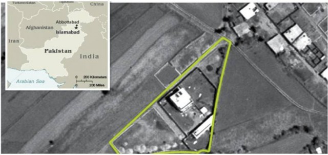
Not sure about the accuracy, but Google Maps has it here:
http://maps.google.com/maps?q=Osama+bin+Laden's+Compound,+Abbott%C4%81bad,+Pakistan&hl=en&view=map&mcsrc=google_reviews&num=10&ie=UTF8&start=0&cid=11196890339658103699&ll=34.186166,73.242148&spn=0.008493,0.008293&t=h&z=17
Interesting, but in that location the imagery is from 2001, not even 2005, so if the intelligence accounts are correct, then this mansion cannot be it — it was already built by 2001.
According to everything written and shown by the post, the Google Maps location is here, http://goo.gl/maps/TiQ5
34.169306,73.242792 (lat,long)
More details here:
http://www.mirror.co.uk/news/top-stories/2011/05/02/osama-bin-laden-killed-the-1million-compound-where-the-al-qaeda-leader-died-115875-23102059/
The photos are correct (also on Al Jazeera), but the map is not. It’s the same compound that already existed in 2001.
At this stage, we see three hypothetical locations.
We’ll see in the next few hours or days which one is the real one.
CNN puts the location of Bin Laden’s compound around here:
http://maps.google.com/maps?t=h&hl=en&ie=UTF8&ll=34.146316,73.217215&spn=0.003689,0.00766&z=18
Wikipedia and others locate it there:
http://maps.google.com/maps?t=h&hl=en&ie=UTF8&ll=34.187543,73.242512&spn=0.007375,0.015321&z=17
Finally, Ogle Earth and others locate it here:
http://maps.google.com/maps?t=h&hl=en&ie=UTF8&ll=34.170719,73.232311&spn=0.007377,0.015321&z=17
http://www.huffingtonpost.com/2011/05/02/osama-bin-laden-dead-abbottabad-mansion_n_856206.html
Your article is mentioned :P
I think these locations are wrong. The key is the red scar on the hill in the background (in the screen shots) which I believe is located at “34 10 22N, 73 15 36E”. Based on trying to match the perspective view I put the compund somewhere to the west near “34 10 22N, 75 15 18E”. The view in the screen shot would be looking east. Another supporting fact is the press reports which state that the area was somewhat remote when construction started – the area sited by Stefan looks too built up in 2001. The screen shot also shows an area with only a few structures.
I actually got a near perfect match of the screenshot looking east from “34 10 14N, 73 15 12E”. Mountains in the background match up as well as red scar. Have to set exaggeration to 1x to make it look right….
I spent several hours going through maps + PK press reports of the “Helio crash” reported prior to the Bin Laden news, and this is the area I guessed as well. Also, look at the Picassa pics scattered around that new development behind Bilal Town and NNE of the Army Housing Project (which is where press said the explosions came from). That’s gotta be the place.
Osama not killed yet, How they get him from Islamabad to the sea in a matter of hours wheras Islambad is over 700-800 miles away from the sea! They would have to have transported him IMMEDIATELY no time for DNA testing or confirmation something smells fishy no pun intended. See truth with Videos & Photos at http://itwel.com/obama-confirmed-osama-killed-updates-photos-and-videos.php
Abbottabad is roughly 700 miles from the arabian sea. If they used a Pave Hawk helicopter, with in-flight-refueling providing unlimited range, they would cruise at about 200 mph, with max speed at 224 mph. They DID transport him immediately, and could have made the trip in little over 3 hours. They don’t need his whole body for DNA testing, only hair samples or cheek swabs.
I think it is here: http://bit.ly/jnWEcM
Dave-
I think you’ve got a typo there. You probably mean 34 10 22N, 73 15 18E. 75 east would be East of Srinagar, in the portion of Kashmir controlled by India.
Yes, sorry! 73 deg east is correct – finger check….
Yes, Dave, looks like your prodding prompted the final push needed to get to right location (see updates)
I made a photo from Google Earth too, with annotations and distances.
http://matbe.net/mGaHFk
Either way, it’s very, VERY close to the PMA for Pakistan not to know 1) he was there and 2) the Americans flew in on helicopters in the middle of the night and sat there for 40 minutes blowing things up and shooting at him without the PMA duty officer wondering what was going on just down the road…
I think the BBC has it wrong. CNN is showing a video from inside the compound and the windows are elliptical. BBC is using a screenshot of wikimapia and I wonder if they are only using wikimapia as a confirmation.
Confirmed:
Pentagon releases aerial shots:
http://www.nationaljournal.com/nationalsecurity/pictures-u-s-photos-of-the-bin-laden-compound-20110502#photo_2
I know very little about helicopters, but does that compound look big enough to fit 2 – 4 helicopters?
Blog on finding the Osama Bin Laden compound and working with the New York Times:
http://www.goleaddog.com/news_blog/blog/
the Blackhawks which the Pentagon says were used, would probably have dropped down one at a time to allow the SEAL operators to either “fast rope” in or disembark in a traditional fashion. either way it would only take seconds for each bird to hover or touch down and the SEALS would fan out to provide protection for subsequent drops.Way to go SEALS and (presumably,) U.S.ARMY 160th S.O.A.R..(of “Blackhawk Down”)
All the stories have related the fact that the people in this compound burned their own trash as opposed to having it picked up. I don’t know anything about trash collection in Pakistan, but it sounds like something that would be more of a urban as opposed to rural thing?
Congratulations on spotting it and with the confirmation. Early reports were indeed erroneous.
High resolution updates (January 15, 2011) from DigitalGlobe:
http://www.flickr.com/photos/digitalglobe-imagery/5680727066/in/photostream
And as one final little bit of confirmation / curiosity, I compared the ridge line from the Al Jazeera screen capture to a similarly oriented view in Google Earth. They match:
You can see it here
Nice!
Playing hide and seek final tally… uncle sam=one, osama bin laden=zero
They also said he didn’t have Internet…but there is clearly a huge satellite dish inside the compound – in all released pictures and diagrams. Please explain.
Well, reports said there were no telephone or internet cables going into the compound. But a satellite dish doesn’t require phone or internet cables. The definitely had electricity.
I Emailed a note to the White House in 2009 that Bin Laden was constructing a house in an erea within a few miles of a facility to treet him. Of course I did not know the area or streets but when I saw the possible construction sites in earlier earth shots I thought that was a possible local for him to hide. I never received a reply.
Robert
Is this your way of laying claim on the $25M bounty?
Oh, yeah, I e-mailed them, too! About the same place! AND I did it in 1991!
I believe there will be little reaction by the Muslim nations to this occurrence. It is evident that the youth in their society has had enough from those controlling political forces. We may find that they may rejoice at the taking out of Bin Ladin. He, like our plos are, are bunch of old cranks, fighting a cause that the youth know very little about and could care less. What they want is life, liberty and the pursuit of happiness. Move over you old jackasses the world is changing. That includes me, since I’m 69.
The final reported Ogle Earth location is correct. I overlaid the CIA provided image with the reported location (N 33.901944° E 70.093746°) and it matched perfectly. I posted the kmz file on Google Earth Keyhole, will update when the post shows up there.
I made an error on that lat/long, it’s actually: 34°10’9.66″ N 73°14’33.1″ E
Here is the link to the .KMZ file. Again, CIA image overlay on Google Earth map data.
http://bbs.keyhole.com/ubb/ubbthreads.php?ubb=download&Number=997495&filename=20110502205102-4dbf7ba60625a6.86117268.kmz
Here it is for Google Earth:
34°10’9.54″N,73°14’33.40″E
34°10’9.50″N
73°14’32.94″E
that’s done!