- Mickey Mellen over at Google Earth Hacks is back to his innovating ways: He’s developed pmShare. It lets you upload placemarks to Google Earth Hacks directly from within Google Earth. Mickey can explain the technical details better himself:
Using some of the techniques I used for GEwar, I’ve developed a couple of custom network links for people to create, post and comment on KML files without leaving GE. It makes some use of the built in web browser (no way around that if people need to type in descriptions, comments, etc), but I’ve kept that to a minimum. Also, I figured out a way to pass their user info to that built-in browser (which I couldn’t do with GEwar), so they don’t need to be logged in on that session of IE for it to work.
The idea was to make it easier for people to share places. Granted, it’s not real hard right now, but it involves adding a placemark, naming it, saving it, finding it after it’s saved, then uploading it again somewhere else. With these new scripts, this all just happens right in GE and posts directly to our site (and also gives them a “send this to a friend” link).
- Do you use Mediawiki? KML Export extension is up to version 1.2.0. What is it? “KML Export is an extension that generates KML files for Google Earth
from content in article pages.” Version 1.2.0 generates KML 2.1.
- Ed Parsons has a good tip for getting your Nokia N95 to hook up with GPS satellites faster. Your N95, because I don’t have mine yet.
KML 3.0: Here within the year. What would you like in it?
Open source geospatial software evangelist Paul Ramsey writes a must-read post for those of us who are curious as to where KML is headed. He’s got minutes of sorts from the most recent Open Geospatial Consortium (OGC) Technical Committee meeting, and while the meeting may have been boring, the news coming out of it is not. For those of us with short attention spans, here are the CliffsNotes:
- KML 2.1 is becoming part of the OGC standards process (we knew this already).
- The OGC will begin work on codifying KML 3.0.
- Google will continue to improve on KML 2.x, and the OGC will decide whether these changes make it into KML 3.0.
- We should get KML 3.0 within the year.
- In Q&A time, Google Earth CTO Michael Jones was asked whether Google being the only vendor involved in extending KML 2.x didn’t give Google too much power in the process. According to Ramsey, Jones replied that “he had approached Microsoft and ESRI to join in the standardization process of KML, and will continue to invite them to the table. In the end, an OGC process with Google and invitations to the others is better than no process at all. I find it hard to disagree with that.”
While we’re on the subject, any wishes for what should go into KML 3.0? I know what I want: A way of controlling the user experience from within the code — for example, by being able to choose whether popups appear in a tour, how fast such a tour should run, and whether a tour should start automatically. I’d also love to have better time-line functionality (along these lines), and the ability to subscribe to GeoRSS and WMS from within KML network links.
Perhaps a bit further off, I’d love a way to be able to turn on or off objects in the middle of a tour process; perhaps this could be done by repurposing the timeline functionality, so that you can set user perspectives at different points in a timeline and also have objects/layers becoming visible/invisible at timeline points. This sort of timeline would be measured in minutes of duration, of course, not absolute time, as the current timeline is in Google Earth. (This suggestion is copied wholesale from Matt Nolan’s EarthSLOT, whose tour functionality truly shines — see this demo).
Oh, and before I forget — how cool would it be if you could use KML to upload your homegrown DEMs to go with your high resolution overlays?
If you think any of these ideas are particularly bad, do let me know as well.
(See a Google Earth feature wishlist from almost exactly a year ago, and check up on what’s been implemented in the meantime. Hint: The Matterhorn is looking rather fantastic in Google Earth these days.)
Mobile mapping news: MoloTwit, FONFinder
Some more mobile mapping news:
- Mologogo, a web service that already lets you use a GPS enabled mobile phone to update your position on Google Earth and Maps, is now also adopting the Twitter “protocol” for sending position updates via SMS. Here’s how to use it. (Via Make)
- FON is a “social” wifi service that’s popular in many countries — if you share your own wifi, you get to use others’ when you travel. This makes it a tempting service for users of mobile phones like the Nokia N80 and N95, which have wifi access. The web browsers on these phones are not ideal for the complicated FON Map, however, which is why Rainer Simon is working on FONFinder. As Rainer writes on his blog, it’s almost finished. When he’s done, you’ll be able to submit an address and get the nearest hotspots delivered to you on a map. Nice idea.
And in the not-too-far-off future, I’m sure, you’ll be able to mash up Mologogo with FONFinder so you don’t even have to submit an address. Just ping FONFinder with MoloTwit and get hotspots back… and perhaps anything else nearby you need.
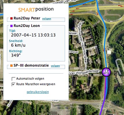
Rotterdam marathon live in Google Earth, Maps
As a way of advertising its wares, Dutch GPS services provider Smart Position is at this very minute relaying live position data of two runners in the Rotterdam Marathon, which started Sunday at 11:00 local time (09:00 UTC). You can watch them via a KML network link and in Google Maps.
Links: Mapping Twitter, Arc2Earth Publisher
- The mobile publishing revolution will be mapped… Twitter Facts lists SEVEN different Twitter mapping solutions. Twittervision cousin Twittermap is especially interesting — it shows the most recent tweets for a given zoomed-in view. So far, no solution that I am aware of offers a network link for Google Earth, and it is not yet possible to see just the georeferenced tweets of the people you subscribe to. But I’m guessing that this is just a matter of time.
- Of interest to GIS pros (but no doubt they already know): Brian Flood & Co’s Arc2Earth Publisher has been released. Arc2Earth Publisher goes beyond the exporting of ESRI ArcGIS content to KML that Arc2Earth Standard does; it can also publish map tiles for Google Earth, the Google Maps API, and the Microsoft Virtual Earth API; it can even write the API code for you; and you have the option of serving the tiles from Amazon S3’s scalable server space. Also, Arc2Earth Publisher can do Google Earth Superoverlays, so that you get progressively higher resolution tiles shown as you zoom in.
The upshot for us consumers? More good content. FYI, Arc2Earth was used in the making of many of the prototypes for the Darfur layers, currently in Google Earth.
- Live Maps/Virtual Earth/Live Local’s product manager responds to the Laudati/Scoble thread on the web app’s inability to gain prominence. He doesn’t seem to think the multiple names are too much of a problem (and I think he is wrong), but he does praise the Google Maps developers for their slick new editing features (as we did:-)
Doctored Aussie tourism ads get flack
Here’s another cautionary tale, lest you’re a tempted to engage in false advertising regarding the relative merits of your local tourist attractions. The state government of Victoria, Australia, is running a campaign promoting the Geelong waterfront with satellite images… except that the images were doctored. The Geelong Advertiser caught them:
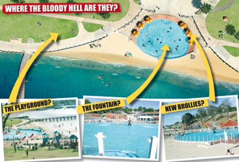
Here, by comparison, is how the view looks in Google Earth:

That’s Digital Globe imagery from 2004, and it’s clear the ad is based on something better and hopefully more recent. But nothing beats sending a reporter over to the waterfront to do a visual check. The result:
City of Greater Geelong Mayor Bruce Harwood said the council was negotiating with Tourism Victoria to change the image because the accuracy was “not quite right”.
While I think there is room for poetic license in the case of something as inconsequential as tourism advertising, it’s interesting to note that as we become savvier about the provenance and availability of such images, we also become more adamant that they convey correct information. And if you doctor images in the cause of tourism, be prepared for a backlash when your tourists actually come, and reality falls short of what you promised.
Links: US election data as KML, Garmin Mac betas, Bird’s Eye how-to
- On his Census KML Data Visualization blog, Aidan Marcuss has been putting all kinds of US census and electoral data into KML, producing some interesting innovations in the process. For example, Here:
I’ve also used the TimeSpan element, so you can load both the 109th and 110th Congress files into Google Earth at one time. Using the time slider you can move between the two Congresses – the effect is pretty cool.
- More Second Life/Google Earth mashing up: 3PointD posts a cool video showing Second Life architect Lordfly Digeridoo doing rapid prototyping in Second Life for a real-world project… and if you look closely, you’ll see that the foundation is a screenshot from Google Earth.
- Announced on the Garmin blog, Apple Mac betas for the POI Loader and Garmin firmware updaters.
- It’s Google Developer Day on May 31, in 10 spots around the globe. Alas, that’s too close to the launch of my other project for me to make it, but don’t let that stop you:-). As Frank points out, geo developers will likely be congregating in Mountain View, CA, as that’s near where Where 2.0 takes place May 29-30.
- Interesting analysis, first by Peter Laudati and then Scoble, on why Microsoft’s mapping projects don’t have the same visibility as Google’s. Laudati moots it’s the lack of a clear name, Scoble thinks it’s the interface. Both are correct, I think — neither the marketing nor the UI are user-centric. But there is a third thing: Google periodically lends its technology to compelling humanitarian causes — Katrina, the Pakistan quake, Darfur… Granted, Microsoft has needed to catch up technology-wise, but if it wants to make its mapping services a media destination, perhaps innovation in using its maps for the greater good is a way to go.
- How does Microsoft’s Bird’s Eye imagery get taken in Europe, anyway? Here’s a video from the UK’s The Gadget Show. Money quote:
By the end of 2008 they hope to have covered 900 European cities, that’s everywhere with a population of more than 50,000 people.
- Digital Urban plays some more with the Nokia N95, using its GPS abilities to track a train journey, and visualizing the resulting KML in Google Earth.