- Over on AECnews.com, Randall Newton alerts us to a press release by Nemetschek North America reminding everyone that many of their VectorWorks 3D authoring applications ($1,400+, Mac & PC) can already read the SketchUp (SKP) file format
nativelyvia a plugin, thus making 3D Warehouse a resource for VectorWorks users as well. “We expect similar announcements in the coming days from other vendors,” comments Randall.Google buys small a company, and the company’s file format becomes the de facto standard. How history repeats itself:-)
- Or does it? The Earth is Square reported a few days ago that NASA World Wind 1.5 will get its own distinct geospatial XML, WWML — a combination of GML and World Wind-specific features. TEiS also points to the WWML spec sheet and a WWML wiki page.
- If anyone is in Denver on May 9, you can catch Brad Schell, ex-founder of @Last (or is that founder of ex-@Last) speaking at a Rockies Venture Club event. (He made SketchUp.)
Category Archives: Uncategorized
Wayfinder Earth beta demo (video!)
I see that Digital Geography has already beaten me to it for a thorough review, so I’ll add the eye candy:
This was taken from a friend’s Nokia N70. The help section makes clear that Wayfinder Earth is free but that there are plenty of extra services you can buy for it: GPS positioning (if you have a USB GPS device) and also bitmapped maps instead of the vector-based ones. Wayfinder says that screen vector-based maps are more bandwidth intensive than bitmaps. This is not a problem on a Swedish 3G network, but might be elsewhere.
And the 3D globe you see isn’t really a true 3D earth in all its glory. Zoom in closer and you get 2D TeleAtlas maps. Still, it’s a very nice effect, and it impresses people when you show it to them, even the techies:-)
Finally, I was really impressed with the search. The database found obscure East vilage (NYC) bookstores and returned details including phone numbers in no time. Same for Sweden, and I’m guessing a whole host of other countries. The maps themselves are chockablock with points of interest.
Wayfinder Earth beta launches
Wayfinder Earth beta is out. It uses maps by TeleAtlas, which also powers MapQuest and Tomtom. Currently only Nokia models are supported. Sony Ericsson support is promised in two weeks, Microsoft Smartphones in a month, with Blackberry and Java phone support to follow. (No eyecandy, unfortunately. Anybody have a newish Nokia phone to try this out on and report back?)
Google Earth: Neighborhood watcher
The recipe for this post contains three ingredients:
- In Switzerland, anyone who wants to put up a new building first has to erect poles at the edges of the proposed construction, indicating the correct size and height, so that neighbors can check for undue obstruction of their view or whether development codes are being broken. It’s a kind of SketchUp Unplugged; on a typical day in a Swiss town you’ll see scores of these future buildings, leaving it to us to color in the transparent walls with our imagination.
- This KMZ file published by the local Stockholm government shows the exact locations of the 20,000 new homes it is building to alleviate a chronic housing shortage here. (Via the ever eagle-eyed Erik Stattin.)
- James Fee asks, who cares about SketchUp? He argues that for GIS pros, the lack of analytical tools in Google Earth means that SketchUp objects placed in Google can’t be anything more than eyecandy.
All this got me thinking. Google Earth is a geobrowser, the first of a new breed of display tools for geographic content, akin to how web browsers display web content. And just as web browsers have come to incorporate client-side programming (Javascript, mainly), we can assume that Google Earth will do the same — SketchUp already comes with Ruby scripting built in, so it’s not outrageous to presuppose that one day soon, objects in Google Earth can be made to interact autonomously, or react to GIS layers. (I would love to get this Space Odyssey space station to rotate.)
Practically, this could lead to the following kind of useful tool: First, imagine a special “3D Warehouse”, just like Google’s but maintained by a local planning authority, containing all the proposed construction in the region. The network link published by this database to Google Earth shows at a minimum the height and extent of every proposed building, accurately georeferenced, or even highly detailed CAD objects for some projects.
Then, imagine being able to mark off regions Google Earth as watch areas. If anything new pops up in the vicinity, you get an alert. You could mark out the line of sight of the view of the sea from your house, for example.
What happens next? If new construction is proposed near you, the network link will have it, and Google Earth will automatically alert you. You can then check it out virtually — and if it worries you, click through to find out more from local records.
This doesn’t necessarily have to happen in Google Earth. There is no reason why future versions of my newsreader couldn’t have proximity alerts for GeoRSS-enabled feeds, just as it now has alerts for specific words. But it would sure be a lot more intuitive in Google Earth.
More SketchUp screencast tutorials
Two great tutorial resources for SketchUp — not to be missed:
- Over 30 SketchUp 5 screencast tutorials, for beginners to intermediate users.
- SketchUcation, “By SketchUp enthusiasts, for SketchUp enthusiasts”, Presents tutorial screencasts in blog-like form. These cover advanced topics as well.
(Via this SketchUp Pro forum post)
Mazda takes the Google Earth marketing road
That Fiat you could win with Google Earth during the Winter Olympics? It was only for a select group of Europeans, so it’s only fair that the Mazda you can now win with Google Earth is for US residents only.

As opposed to the Fiat sweepstakes, this new game actually requires some geography skills. It looks slick, too. But from the marketing perspective, it’s interesting to note that Google has now managed to recruit a decent group of high-profile brands to run campaigns that require young hip people to download Google Earth — Adidas, Fiat, Discovery Channel and now Mazda. (Not sure what to make of the Maxim stunt.) Mazda even boasts about it in their Press release:
Leveraging the popularity of Google Earth, a free software application run through Earth.Google.com that combines satellite imagery, maps and a powerful search engine, users will be able to use video clues to search all over the globe for a chance to win a brand new Mazda CX-7.
And later:
“This multi-tiered campaign is a great example of how Mazda has gone beyond basic marketing tactics to embrace emerging technologies in communicating to consumers,” said Brian Colianni, senior vice president of sales and marketing, MNAO.
It’s interesting to speculate whether Mazda gets incentives from Google to include Google Earth in a campaign like this — after all, Google is willing to pay for installs of Firefox with the Google toolbar, so why not pay for installs of Google Earth, thus helping to defray the costs of the campaign for Mazda? Or is the cachet that Mazda gets from associating itself with the next-generation browser enough compensation? (No money changed hands in the content deal with the Discovery Channel, for example, as reported by the Washington Post.)
Brave New Space Odyssey
As a Stanley Kubrick fan, this hits a major soft spot: “hwtnv” took Station V from the Space Odyssey 3D Modeling Archive (who knew such a wonderful resource existed!), wrung it through SOLA’s 3D-to-KML converter (a newer version, dubbed G1, is out since Ogle Earth blogged it a few days ago), and published it to Google Earth Community.
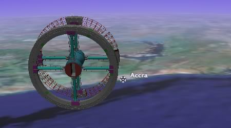
It so realistic, it’s almost painful not to have it rotate. (VIa GE Maniacs, which also points to the Celestia Motherload, where you can download all manner of Space Odyssey models for Celestia.)