- French Google blog Zorgloob looks at the imagery of the new aerial maps accompanying the French yellow pages — provided by the Institut Géographique National (IGN), who will produce Géoportail, France’s answer to Google Earth.
Zorgloob speculates that this imagery will become the base layer for Géoportail as well. The verdict: IGN’s imagery is better than Google’s in the countryside, but Google’s imagery in large cities is of a higher resolution. There are also some gaps and/or censored bits in IGN’s data. And, of course, Géoportail will only cover France.
- Google Earth Logger is a freeware Palm application that creates a KML tracking file from a connected GPS device.
- One of the most impressive regions I’ve travelled through is the Karakoram mountain range in Pakistan-administered Kashmir. Over on Google Earth Community, Waqas_ has put together an exhaustive link collection for the region with annotated placemarks for practically every peak, valley and village. Google Earth really comes into its own in mountain ranges, and the Karakoram is the best one out there.
And if you find a nice spot, go look for pictures of it here on TrekEarth. (Via this amazing photograph on Flickr)
- I haven’t tested this, as I have yet to install Boot Camp on my MacBook Pro, but Smithsonian has posted an updated version of his EarthAnimator — a weather map animator for Google Earth — to Google Earth Community. He’s looking for feedback. (It requires Microsoft’s .NET 2.0 framework.)
Category Archives: Uncategorized
BIMLibrary: 3D object database with extra attributes
BIMLibrary is an soon-to-be-launched Building Information modeling (BIM) component library for architects and designers that will, among other things,
… support the retention and export of accurate product attributes and performance characteristics from the preliminary design stage all the way through to final construction document creation, thereby reducing errors and omissions which result in change orders and cost overruns during the construction process.
Sounds a bit like what Avi Bar-Ze’ev was wishing for a few weeks ago. Future versions of BIMLibrary will support SketchUp, apparently.
Google Earth Linux will be native, after all
Previous reporting was perhaps not as clear as it could have been about how Google Earth for Linux will be ported — natively or via Wine? Now there is no more doubt: According to the Picasa Linux FAQ, Google Earth will be a native Linux application. (Via Ed Burnette’s Dev Connection)
The $100 question: Will Google Earth Linux run on the One Laptop per Child laptop? The system specs may just squeeze by the low end of Google Earth’s requirements, but even so, most of the developing world is priced out of broadband connectivity.
World’s largest crater discovered (with eye candy)
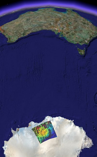 On Google Earth Hacks, an overlay of a just-discovered mega crater under the ice of Wilkes Land, Antarctica. It’s 500 kilometers wide — larger than the current record-holder, the 300-km wide Vredefort crater in South Africa — and it is the new front-runner for the cause of the Permian-Triassic extinction 250 million years ago. Scientists also suspect it may have begun the breakup of Gondwana land. Read more in this Science Daily article from June 1, 2006. (On site confirmation is still pending, however. Some people get all the fun:-)
How do you find a crater under kilometers of ice? You use gravity sensing satellites, like NASA’s two GRACE satellites, which are so sensitive they can measure the gravitational effect of heavy rainfall.
Human rights violations in Zimbabwe, now visible in Google Earth
Ethan Zuckerman and Jason Kottke have blogged the release of aerial imagery by the American Association for the Advancement of Science (AAAS) showing the disappearance of Porta Farm, a settlement of over 6,000 people on the outskirts of Harare, Zimbabwe. It is one of the direct effects of Operation Murambatsvina, Mugabe’s forced slum clearing program from 2005.
The AAAS press release links to two images of Porta Farm it commissioned from DigitalGlobe, one taken in 2002 and one taken in 2006, after the razing. These images are not georeferenced, however, and have not been given the wider context that an overlay in Google Earth can provide. How far from Harare is Porta Farm? Why might it have been targeted for demolition?
I went looking for the precise spot in Google Earth where these images were taken. I noticed that on the most recent image, a road is being turned into a highway, so I followed the only highway west from Harare, hoping to find features similar to that shown in the images. I soon found the place, a little beyond Google Earth’s built-in high resolution base layer for Harare. It looks indeed like Porta Farm’s crime was lying too close to a “modern” highway — turning it into a constant reminder of Mugabe’s questionable national development priorities.
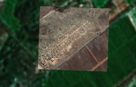
(2002, Image credit: DigitalGlobe)
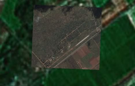
(2006, Image credit: DigitalGlobe)
You can see both images in their proper context via this KMZ file (1.1MB). Double-click on the folder to zoom in. Play with the individual transparency sliders for each image layer to see the comparison.
GEED is good
Johan Hendriks emails to tell of Orange Tea, a new Dutch website that aims to “become THE most important and up-to-date Google Earth portal.”
To show it means business, Orange Tea has produced a KMZ file with 3D models of all the World Cup football stadiums in Germany. (You have to turn off Google Earth’s Terrain feature to view them, though.)
More intriguing, perhaps, is a demo video of an upcoming product of theirs that visualizes Microsoft CRM data in 3D in Google Earth. (You need to give them your email first, though.)
If you speak Dutch, you can learn more about the company behind Orange Tea: Green Tea, which offers Internet strategizing services, SEO, Microsoft CRM develpment, and something it calls GEED, “Google Earth Experience Dynamics”. As their website has no permalinks for individual pages, I can’t link you there directly, though.
Shorts: Java quake overlays, Arc2Earth update, Second Life mashups
- Mikel Maron at Brain Off turns post-Java quake aerial assessment images into a layer for Google Earth. (Caution, huge file.)
- Brian Flood updates Arc2Earth so that Google Warehouse content can be directly imported into Google Earth from the native SketchUp format, rather than have to manually create KML for those objects that don’t already have it.
- A Flickr – Second Life mashup, with video demo, making use of new API features introduced inthe latest release.
- Elsewhere, somebody’s hacked Second Life’s new built-in 2D web browser so that it can show actual web content, not just SL’s help section. Convergence continues apace. (Via Clickable Culture)