- rsgrillo writes that he has already updated his free-yet-very-capable GE-Path tool to be compatible with KML 2.1. (It’s now up to v.1.4.1 — for Windows.) An update for GE-Graph is in the works, he adds. In the meantime, please report bugs.
- Tractor-owning southern Alaskan golfer Avi Bar-Ze’ev posts the first big-picture musings on the implications of the new KML features and the integration between Picasa and Google Earth.
- Not having tested it myself, Google Earth Community poster Marc_B instead explains how to use Google Earth from within Picasa.
- Brian Flood says that the next version of Arc2Earth will automate the production of KML Super-Overlays from ArcGIS raster files:
The tile cutting routines were already in the [Arc2Earth] product but until the 2.1 spec, there was no good way to efficientlly load and display them from GE. kudos to Google for this support!
- Product announcement: A tool to export all manner of content from Intergraph’s GeoMedia into KML, by Austrian company GISQUADRAT. Here’s a lovely brochure in German.
- Skyline announces a virtual globe competitor, SkylineGlobe, “available for the public shortly.” Looks like it will be a Windows only release, judging by the screenshots. (Via Geography 2.0)
Category Archives: Uncategorized
Google Earth 4.0 release note gems
I keep on forgettting to blog Google Earth 4.0 beta’s release notes. It’s a fount of troubleshooting tips (especially for your graphics card). There are also some otherwise unheralded gems:
- You can navigate diagonally by pressing combinations of cursor keys (such as up and left).
- You can now get high-resolution imagery across the entire screen, not just the middle squares (at least if you crank up all the settings in the preferences/ options pane.)
From a long list, here are two very useful workarounds (quoting verbatim):
– Drag-n-drop inside the Places window doesn’t scroll and doesn’t give enough visual feedback. You can use cut-paste to move items long distances in the scroll.
– If you enable a folder full of overlays, you may require more resources (video memory and main memory) than your system is capable of. Killing the application may be your only exit.
Re the navigation: You may have noticed that the new transparent navigator is missing the button that returned you to the 90-degree top-down view. Instead, just type U. To orient North, double click on the N in the navigator, or just type N. To do both, save a keystroke and type R.
Just for the record, it’s possible to navigate using only keyboard shortcuts: Shift + the cursor keys changes tilt and direction; Mac-Command or Win-Option + up or down keys zooms in and out. (The “+” and “-” keys work too.) Adding the Option key to all these combinations slows down the movement, for fine tuning. This is how I navigate most of the time.
Google Earth at the office? You need Pro
The EULA for the Free and Plus version of Google Earth 4.0 has had a slight reorganization, with a crucial sentence getting promoted nearer to the top.
Before (version 3.0):
1. LICENSE GRANT This Software is for non-commercial use only and your rights in the Software are strictly limited to home, personal or recreational use only by you and not for the benefit of third parties.
[ … Lots of legalese … ] You may not use the Software or the geographical information made available for display using the Software, or any prints or screen outputs generated with the Software in any commercial or business environment or for any commercial or business purposes for yourself or any third parties.
After (version 4.0 beta):
1. USE OF SOFTWARE The Software is made available to you for your personal, non-commercial use only. You may not use the Software or the geographical information made available for display using the Software, or any prints or screen outputs generated with the Software in any commercial or business environment or for any commercial or business purposes for yourself or any third parties.
That’s the hint an earlier Ogle Earth post was looking for: Do not use Google Earth Free or Plus at the office (“commercial or business environment”). You’ll need to pay $400 per year for a Pro license. Here’s a product comparison chart for the Free, Plus and Pro versions.
Google Earth as universal geobrowser hasn’t quite arrived yet. If you need a free geobrowser at work, use the very capable NASA World Wind. It too runs KML, though not yet the fancier parts of KML 2.1.
Where 2.0, Day 1: Web favorites
Where 2.0 is getting plenty of blogging coverage. I’m reading lots via Planet Geospatial, so no need to duplicate the effort here. Nevertheless, some favorites from day one:
- Glenn Letham’s Where 2.0 photos on Flickr.
- Where 2.0’s “official” photos, also on Flickr.
- Juice Anaytics’ KML files of US census data works perfectly in Google Maps, and was demoed by Google.
- Ed Parsons on sleeping with the bear…
Google Earth – Picasa integration, any minute now…
It looks like Google’s geo-announcements for the week aren’t over yet.
A few hours ago, sharable web albums for Google’s new version of the Picasa photo editor went live for a test run, and the resulting functionality is not unlike Flickr’s. Here is a sample public gallery. (CNET has an early review, Google Blogoscoped does a roundup of early feedback. Me, I’m still waiting on my Web albums invite:-)
Now for the geo-news: On Flickr, an intriguing screenshot shows Flickr user Adski georeferencing/geotagging his Picasa photos from within Google Earth. His photos are listed like placemarks in his Places pane, like so:

That’s news too me, and if confirmed, very cool indeed. (Although it’s not clear from the example, it looks like two-way integration between the applications.) We’ll have to await a formal announcement to see wether this also heralds server-hosted My Places for Google Earth, in addition to Picasa photos. It would certainly be in keeping with the direction Google has been heading in for its most recent launches.
Where 2 Now: Pics, GeoRSS, tips and debug tricks
- Spanaut took lots of great pictures of Google’s Geo Developer Day and put them on Flickr.
- Mikel Maron’s GeoRSS talk at Where 2.0 is getting good airplay: O’Reilly Radar succinctly lists Mikel’s top four reasons for using GeoRSS:
- Linking systems. (One more less thing to find agreement on)
- Monitoring geographic wikis (like OpenStreetMap or Tagzania)
- Syndicating sensor data
- Tearing down the walls (through standardization)
GeoRSS Blog links to Mikel’s PowerPoint presentation. Must read!
BTW, considering how none of Google’s product announcements involved support for GeoRSS, did anybody ask a Google person about the company’s plans regarding the emerging standard?
- On Google Earth Community, notable developer rsgrillo discovers:
The kml files generated by the new GE 4 uses a linefeed CHR(10) character to terminate a line.
In the previous versions the lines were terminated by a carriage return CHR(13).
If you’re a developer, read the rest.
- PenguinOpus nudges developers towards a wonderful new debugging feature — you can copy and paste KML between Google Earth and the clipboard. Valery35 spells it out in a comment:
1. Select placemark, folder etc
2. Copy to clipboard (Ctrl+C, Ctrl+X)
3. Paste into Notepad or other text editor (Ctrl+V)
4. Change KML text. You can use Search+Replace, Undo etc commands.
5. Select text and copy to clipboard. You can select part of text, if it correct KML
<:folder>…<:/folder>, <:document>…<:/document> etc. If you copy KML with error, then it is simple not pasted.
6. Paste into GE. Enjoy!
- Mapdex’s Jeremy wishes Google developers had some more GIS background. He explains.
- Another Where 2.0 KML-related press release: Media Machines announces KML2X3D, where X3D is an ISO standard for 3D computer graphics. (Too much going on right now for me to read up on this, but I will when Where 2.0 is over.) My hunch is that the support for X3D announced today, which dovetails Google’s embrace of COLLADA for textures in KML yesterday, is the beginning of far more game-like uses for Google Earth. (More on X3D)
- They announced it last week, but are announcing it again at Where 2.0, for good measure, or something: AutoDesk Civil 3D 2007 has an extension for exporting KML. At least it’s garnering a good blog review at Between the Poles.
- BTW, Anything GeoSpatial has been doing some great liveblogging of Where 2.0, in case you’re not there.
Google Earth, archivist: The last days of Carteret Atoll
In the 18th-century exploration business, like in any other pursuit, there were winners and there were losers. Philip Carteret was definitely the latter. In 1766, as ambitious young British Navy Officer, he was given a shoddy ship, no support, and ordered into the Pacific. He managed to sail straight across it, prevailing over scurvy, thirst, and attacks by locals. He put a good number of islands on the map, and charted new routes that would later be used by British ships sailing for Australia and China.
So why isn’t he famous? Because of James Cook. Cook found Australia and New Zealand just as Carteret’s expedition was limping home. Cook would go on to become a British hero; Carteret managed to name a minuscule atoll after himself and was then laid off, soon to be forgotten.
I learned all this after chancing upon a back issue of New Scientist magazine while staying at a friend’s place. (2006-02-11, readable online, £2.95.) The punchline that forms the premise of the article is that after 350 years, Carteret is about to be forgotten all over again. The atoll he named after himself, now part of Papua New Guinea, is about to disappear, washed away by a rising ocean. Its 1,000 inhabitants wil be relocated to nearby Bougainville Island by 2015, when Carteret Atoll is expected to be submerged completely.
News of these “first climate change refugees” has been covered by the press for a while. A 2001 Straits Times article calls the disappearing atoll a “dress rehearsal for global warming.” A Guardian article from November 2005 documents the plight of the islanders, and the decision to move them.
I read the New Scientist article yesterday in the wake of last week’s massive Google Earth dataset update, and wondered if the atoll might not now be having one final high-resolution curtain call before being swallowed up whole by the sea.
I first had to find Carteret Atoll. Wikipedia helped immediately: There are two articles (Carteret Islands, Carteret Atoll), the first with coordinates. A visual check on OceanDots.com confirmed that the atoll at that location is indeed Carteret’s discovery.
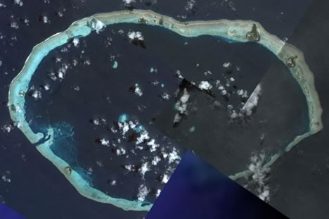
Image credit: DigitalGlobe in Google Earth
Luckily for this blog post, the latest update reveals the atoll in glorious high resolution. In fact, the resolution is so good that you can make out individual palm fronds. There are six inhabited islands dotted along a ringlike coral reef — only the largest settlement is named in Google Earth: Weiteli, on Han Island. (The Guardian reports that Han was completely indundated by a storm surge in 1995. Another island broke into two.)
Is climate change the cause of Carteret Atoll’s disappearing act? Probably yes, though Wikipedia lists two alternate theories: overfishing with dynamite, and tectonic plate shifts in a region where the Earth’s crust is disappearing.
Here is a KML file with the islands. Here is the same KML file in Google Maps, because we can:-) It also shows you what the dataset was like before last Thursday. Bonus: A portfolio of B&W photos taken on the Carteret Atoll in 1960, from the National Library of Australia.