In the 18th-century exploration business, like in any other pursuit, there were winners and there were losers. Philip Carteret was definitely the latter. In 1766, as ambitious young British Navy Officer, he was given a shoddy ship, no support, and ordered into the Pacific. He managed to sail straight across it, prevailing over scurvy, thirst, and attacks by locals. He put a good number of islands on the map, and charted new routes that would later be used by British ships sailing for Australia and China.
So why isn’t he famous? Because of James Cook. Cook found Australia and New Zealand just as Carteret’s expedition was limping home. Cook would go on to become a British hero; Carteret managed to name a minuscule atoll after himself and was then laid off, soon to be forgotten.
I learned all this after chancing upon a back issue of New Scientist magazine while staying at a friend’s place. (2006-02-11, readable online, £2.95.) The punchline that forms the premise of the article is that after 350 years, Carteret is about to be forgotten all over again. The atoll he named after himself, now part of Papua New Guinea, is about to disappear, washed away by a rising ocean. Its 1,000 inhabitants wil be relocated to nearby Bougainville Island by 2015, when Carteret Atoll is expected to be submerged completely.
News of these “first climate change refugees” has been covered by the press for a while. A 2001 Straits Times article calls the disappearing atoll a “dress rehearsal for global warming.” A Guardian article from November 2005 documents the plight of the islanders, and the decision to move them.
I read the New Scientist article yesterday in the wake of last week’s massive Google Earth dataset update, and wondered if the atoll might not now be having one final high-resolution curtain call before being swallowed up whole by the sea.
I first had to find Carteret Atoll. Wikipedia helped immediately: There are two articles (Carteret Islands, Carteret Atoll), the first with coordinates. A visual check on OceanDots.com confirmed that the atoll at that location is indeed Carteret’s discovery.
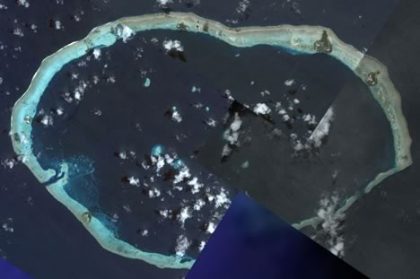
Image credit: DigitalGlobe in Google Earth
Luckily for this blog post, the latest update reveals the atoll in glorious high resolution. In fact, the resolution is so good that you can make out individual palm fronds. There are six inhabited islands dotted along a ringlike coral reef — only the largest settlement is named in Google Earth: Weiteli, on Han Island. (The Guardian reports that Han was completely indundated by a storm surge in 1995. Another island broke into two.)
Is climate change the cause of Carteret Atoll’s disappearing act? Probably yes, though Wikipedia lists two alternate theories: overfishing with dynamite, and tectonic plate shifts in a region where the Earth’s crust is disappearing.
Here is a KML file with the islands. Here is the same KML file in Google Maps, because we can:-) It also shows you what the dataset was like before last Thursday. Bonus: A portfolio of B&W photos taken on the Carteret Atoll in 1960, from the National Library of Australia.