- Darryl Lyon’s Blog alerts me to a demo of what I consider to be something of a killer feature for virtual globes: “Video on terrain”, depicted rather persuasively with SkylineGlobe in this CNet online video from Where 2.0. Granted, SkylineGlobe isn’t out yet, and there is no way to know how scalable this feature is, but only two months ago, video painted onto 3D surfaces was high-end stuff for a media lab — witness GeoDec (third item from the top — and note who is sponsoring GeoDec; gotta love competition).
- Tim Beermann, maker of Shape2Earth (beta), writes a succinct “state of the geobrowsers” post worth reading, including the comments. (BTW, Shape2Earth works fine in Google Earth 4 (beta), according to one user.)
- I’m not sure if the network links ever did show the V70 sailing race in the North Sea live, but these snapshots on ZNO of the race in progress depict some very nifty sailboat model rendering work by ZNO that you can zoom onto. Mediality has more on the race itself.
- And the user-authored 3D-fication of Google’s Earth begins in earnest: Ciko does the buildings for downtown Jakarta (English text and link at the bottom of the post.)
- IntelliGolf 8.0 for PocketPC lets you use Google Earth to enter golf course information before you play on it.
Category Archives: Uncategorized
ActiveX + Google Earth? 1998 all over again
GemGids.nl is an initiative by Dutch municipalities — still in the pilot phase — to make their geospatial information available to citizens via Google Earth. That much is laudable. Less so is their decision to use ActiveX controls to link the web component to Google Earth.

ActiveX is a Windows-only technology that, among other things, lets Windows web browsers control other Windows applications. This makes for great hacking and tinkering, and several clever tools have been written with it to control Google Earth. But it self-evidently doesn’t work for Mac and Linux versions of Google Earth.
That’s not a problem if you’re a hacker intent on pushing the envelope. Nor is it a problem if you’re a company making a business decision to focus on just the Windows market. But if you’re the public sector, then limiting your services to one endorsed operating system is just not on. We went through this phase in the late 1990s with proprietary technologies for web browsers — try it today and you’d get laughed out of the developers’ meeting… unless it’s held in Voorst municipality, obviously.
The problem with ActiveX is that it caters to programmers with specific skill sets, rather than to the needs of (taxpaying) users — and that’s a backwards way to develop a service. What’s more, there are perfectly good ways of retrieving personalized content for viewing in Google Earth without using ActiveX; as long ago as August 2005, Google Earth Hacks‘ Mickey showed with GEWar that network links with unique personalized URLs can achieve the same result. The more recent fancy-looking competitions that ran on Google Earth managed it as well.
A final irony is that one of the development partners, EGEM, says (in Dutch) it is responsible for assuring the project subscribes to open standards. I couldn’t agree more — I’m looking forward to the version that works with Firefox in Linux.
Short news: Mo’ Mao, Apple Mail 2 Earth, patent law
- David Hsieh has been hunting for large slogans on Chinese mountainsides. Churned through my Mac’s translator widget, I get “Overcomes all difficulties to strive for the victory”, “Only struggles from morning until evening”, “Serves for the people”, “Chairman Mao long live” and “The Shangrila – pine approves the forest temple” (a religious text, assures David).
- Good news for Mac users: The latest update of Brian Toth’s excellent Google Maps plugin for Address Book adds support for Google Earth and benefits from Google’s expanded geocoding for a bevy of European countries. The plugin is now a Universal binary to boot.
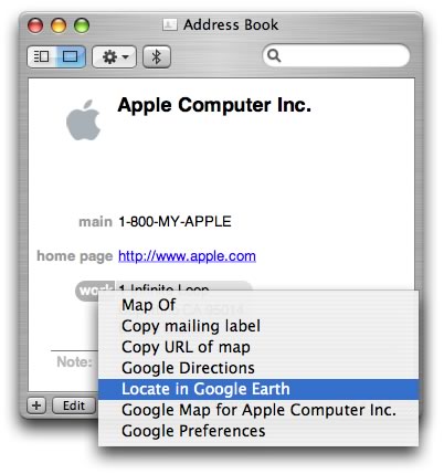
This is what address books should look like by default. I might even begin to add people’s addresses to mine:-) (Via Faded Pictures)
- The Technology Liberation Front has a go at the Skyline patent suit vs. Google Earth, and finds it lacking. Not so fast, argues Daniel Markham. [Update 2006-06-18: Avi Bar-Ze’ev comments as well.]
- Maybe you already knew this, but I did not: Platial’s Today Nearby links its maps to Google Earth. The RSS could go GeoRSS, though. (Via Digg)
Short news: Google Earth as GeoRSS reader; switching geocoders
- Ooh, ah, a GeoRSS reader is coming soon to Google Earth. Andy Armstrong posted a picture to Flickr of his work for geofeed.org. My guess is that it’s a web service not unlike Newsgator that serves GeoRSS feeds as a network link to Google Earth. This ought to be very useful. (Nothing to see yet at geofeed.org.
Or did he mean geofeed.net?) - Phillip Holmstrand considers switching from Yahoo!’s geocoder to Google’s newly announced one for Batch Geocode, on account of the high daily limit (50,000 requests) and the fact that Google’s geocoder does several European countries.
- Ed Parsons again sums up neatly Where 2.0, day two.
- On GIS for Archaeology and CRM, Matt posts a tutorial on georeferencing with Picasa and Google Earth for archaeologists, using a dig in Pennsylavnia as an example. He throws in a use for SketchUp, for good measure.
- The Earth is Square has a preview of 3D buildings in NASA World Wind.
- Off-topic, but too cool not to mention: Sometime Google Earth activist Kathryn Cramer has been retained by Wolfram Research to run the Wolfram Science Conference Blog for NKS2006, How does one go about getting a job like that?
Analytics2KML: Visualize Google Analytics data in Google Earth
Quick quiz: Where else is geospatial data lurking on Google’s server farms, ready for visualizing in Google Earth? If you answered Google Analytics, you get a prize, and it’s the online Analytics2KML converter, developed by Jacob Cord.
I feel Ogle Earth is suffering a little from superlative-inflation of late, and I need to do something about it, but not until the next post: This converter is extremely cool, and works exactly as advertised. By way of example, here is a KMZ file of all the locations of all the georeferenced visits to Ogle Earth on June 14, 2006.
Jacob also posts the source code and a Linux binary here.
If Google were to do this instead of Jacob, they could automate the process, providing URLs to KML network links that update automatically — a little like how the personal iCal links work in Google Calendar. They could also prettify the visualization, for example by using sized 3D models to indicate the number of visitors from a location. Google is quite possibly already working on all this, as it is an obvious mashup candidate (with hindsight, okay), but if they’re not, I think I know somebody just right for the job:-)
[Update 00:02 2006-06-16: It just occurred to me to wonder where all this international geocoding was being done. It turns out it’s done by Google Analytics, and the coordinates are exported along with the rest of the data.]
Street-level London demo for Google Earth 4.0
Digital Distributed Environment‘s Andrew Hudson-Smith applied textures to a model of a row of houses in London, using his own in-house software to ensure accurate scaling of the photographs. The result, viewed in Google Earth, is very cool, and it’s a precurser of what we can expect to see much more of:
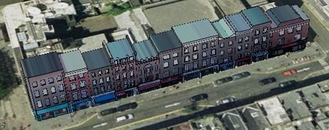
I especially like how the signs and awnings are rendered in 3D and textured. It’s a lovely touch, and it is easy to imagine walking along this street:

My other initial impression is that this technology is going to provide a potent new weapon in the “eye candy wars” that Google and Microsoft are informally engaged in. Live Local’s “bird’s eye view” imagery can’t compete with such imagery pasted onto true 3D models. We’ll have to wait and see how Microsoft leverages its purchase of Vexcel and Geotango in response.
Andrew asks for feedback. In my case, Google Earth 4.0 Free for Mac handled the file well, after one initial crash and then a bout of the hiccups that cleared up by itself. Just don’t forget that GE4 is _beta_; it sometimes stalls for me on other files as well.
Picasa + Google Earth = bliss
I’ve been trying out the test version of Picasa that publishes web albums and lets you geotag photos with Google Earth. I imported some photos of Stockholm, geotagged them, and published them as a web album.
I’m completely impressed. The process manages to combine absolute ease of use with all the power that Google Earth now musters. It took me no time at all to pinpoint seven photos to within a meter’s accuracy, and I found myself smiling at the ingenuity of it all.
Here’s how it works: Start with some imported photos. Highlight them. Go to the Tools menu, select Geotag > Geotag with Google Earth.
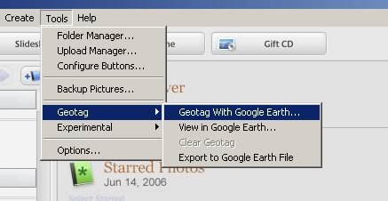
Google Earth pops up with big crosshairs at the center of the screen. At the edge of the screen, a floating window that shows you the photo you need to georeference.
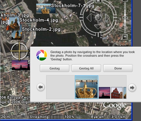
Drag the Earth. Click. Next. Repeat until done. Placemark icons are generated automatically from the image, and the collected whole is turned into a folder ready for export as KML. (Here is the KMZ file of the Stockholm photos.) Once Done, Picasa marks the photo icons with a small symbol, denoting that they have been geotagged.
Publishing them to a web album is just as seamless. Push a button, log in to your Google account, choose a name and whether your folder is public, and you’re done. in fact, once you have a Picasa Web Album account, you don’t even need the Picasa standalone application. You can upload photos directly, via the web client, albeit without Picasa’s georeferencing abilities.
There is still room for development, of course. The public web albums do not yet offer up a KML link for georeferenced photos, and the RSS feed that accompanies the photos does not do GeoRSS. Integration with Google Maps would also make sense, in case you’re travelling and want to georeference your roadrip pictures. I’m sure it’s just a matter of time.
The integration between Picasa and Google Earth is the first instance I can think of from the past year where Google develops something geo-savvy that risks competing with the freelance developers in its ecosphere. There are other tools out there that use Maps and Earth to georeference photos, mainly connected to Flickr, but also dedicated ones, like Panoramio. (Panoramio’s strengths lie elsewhere, though — in social mapping.) In this case, however, the advantage of the ease of use of the integration is so great, that anyone using Google Earth should download Picasa, and anyone with Picasa should download Google Earth. And that’s precisely how the game is won against Microsoft and Yahoo!.
What about Apple’s iPhoto? That only integrates with .Mac’s web publishing, for which you pay, and there are no georeferencing tools in sight. Picasa is looking far more interesting at the moment. Luckily, my MacBook Pro boots into Windows:-)