- Okay, so another Chinese submarine tunnel has been identified, this time by East-Asia-Intel.com, but is it really so hard for them to give us a placemark so we can go look for ourselves? It took all of 10 seconds scouring the high resolution areas of Hainan before it popped out at me. Anyways, I’ve posted the placemark to Google Earth Community (entire post). (Here is another submarine tunnel, blogged back in February.) (Via Intelligence Watch)
- If for whatever reason you do not already have Avi Bar-Ze’ev’s feed in your reader, he’s got another post on the Skyline patent suit that’s well worth reading. [Update 2006-08-09: The Earth is Square retorts.
- It’s official — Mapdex‘s Jeremy Bartley is leaving the Kansas Geological Survey to join ESRI’s core ArcGIS Server team. Congrats. I sincerely hope Mapdex doesn’t go a way as a result.
Category Archives: Uncategorized
Google Earth’s Israel imagery gets flak
Regular reader Rip points to a post on a blog maintained by Israel-based Defense-Update.com entitled “Iranian made [unmanned aerial vehicle (UAV)] Intercepted Over the Israeli Mediterranean Coast“. Relevant bit for our purposes:
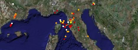
The Hezbollah conducts extensive intelligence gathering activity to improve its capability to target sensitive Israeli sites, utilizing signals intelligence (SIGINT), long range observations conducted by its own forces, as well as utilizing intelligence support and weather forecasts (required for accurate aiming of its medium range rockets) provided by Syria. Target analysis, including coordinates gathering has been dramatically improved in recent months, as a significant part of Israel was included in “Google Earth” service, offering everyone a free access to relatively high resolution satellite images of Israel, provided with fairly accurate GPS coordinates which are accurate enough to support the aiming of rocket attacks.
The high resolution imagery of northern Israel by DigitalGlobe added to Google Earth’s dataset in early June 2006 is from 2002 and 2003. It is for sale to the public. Iran and Syria have access to far more recent and accurate satellite imagery. The notion of Hezbollah waiting on Google Earth to acquire target coordinates for their long-standing rocket arsenal is ludicrous, in my opinion. While Google Earth would do a “good enough” job of providing such data for permanent landmarks, any army with pretensions of competency would long have access to such coordinate data.
Rip has his own good points:
Note unguided rockets are quite different than UAVs; their Circular Error Probable (CEPs) upon arrival at the end of their flight are fairly gross. Knowing the exact distance and heading from the launcher to the target likely helps a bit. It reduces the CEP from terrible to very bad. I have seen no comments about any survey (large or small) to compare GE derived ground coordinates to ground truth. In any case, the inventory of Hezbollah UAVs has to be quite tiny so the threat they present is mostly propagandistic.
Yes, GE and GPS do provide weapon guidance potential (i.e., targeting) for “ballpark” (as “in the ballpark”) hits by unguided rockets; but, there are a host of other factors which hugely vary the effectiveness of non-terminally guided munitions.
Welcome to another effect of globalization…
(Caveat empor: This post is about a war. The first casualty of war is often truth. While the source material for this item looks credible to me, I can’t substantiate it.)
DIY lightning maps
Sensor webs are very cool. Collaborative sensor webs are even cooler. Blitzortung.org is a user-contributed lightning data network for central Europe. if you have a directional lightning detector and a PC connected to the internet, you too can help construct a European lightning map in near-real time.
And then, you can look at it via a network link in Google Earth. (There are stand-alone viewers as well.)
Bahrain bans Google Earth
Mahmood’s Den is reporting that Bahrain’s Ministry of Information has instructed the country’s internet exchange to block access to Google Earth servers, citing Al-Wasat News. I don’t speak Arabic, but Systran’s automated Arabic-English translation service comes to the rescue (it still needs some work, clearly:-):
Knew “the middle” that in familiarity of Bahrain for the Internet, faithful second step have fun after lewd locking the sites, decided yesterday closing of service “[GwGl] [aayrth]”, which manages from during her [mtSfHH] the Internet from watching the geographical informers and the natural maps for any area in the scientist.
No more [Gwgl] [aayrth] for Bahrainis, then, unless they avail themselves of Tor, as Mahmood points out.
I’m curious as to whether Google Maps has been blocked, or for that matter other mapping sites. Mahmood attributes the motivation to a desire to shield Bahrainis from the opulence of rich Bahrainis’ residences. For example, here is where the king’s uncle lives:
I suspect that the measure was instituted only because looking at royal property had become a very popular pastime for the locals recently. Nevertheless, the ban is somewhat surprising — Bahrain is a constitutional monarchy, but it is among the more progressive countries in the region (though everything’s relative). (Via Global Voices)
[Update 00:03 UTC: Slashdot has it too, with a link to Google’s translation, which does a better job of it.]
[Update 00:14 UTC: The ban does not seem to be having the intended effect (surprise surprise).SIlly Bahraini Girl writes:
Now someone.. anyone.. just tell me how to download images from Google Earth and I am game guys.. Tell me what you want me to zoom into and how to get the images published, and your wish is my command!
Google Earth saves
A few weeks ago, the health services of Amsterdam tracked down an outbreak of Legionnaires’ disease using Google Earth, reports Trouw, a Dutch newspaper, today.
The details, translated from Dutch: Starting July 6, around 30 people became infected, of which two died. Soon, a certain type of “cooling tower” in the center of the city was suspected of being the culprit, but Dutch authorities did not have a list of such towers to inspect. Instead, health workers used Google Earth to visually identify all buildings in the area that had such towers on their roofs, and then contacted building management in each to determine whether it was the at-risk kind.
On July 18, one of the identified towers — on top of the old central post office building just to the east of Amsterdam’s central station — proved to be the origin of the outbreak. End of story.
You might wonder, of course, why Dutch authorities didn’t use some kind of official national imaging system. I suspect the reason is that Google Earth’s dataset (minus the bits censored by the Dutch government) is pretty much as good as it gets when it comes to coverage of Amsterdam, and that speed was of the essence. Still, a large area just to the east of the central station is thoroughly censored (it’s the Navy barracks in Amsterdam), so imagine if that’s where the outbreak had in fact started — they’d still be looking. (Via Jan Marijnissen Weblog)
Short news: Sri Lanka; World Wind secrets; Sketchup training
- As high resolution imagery of Sri Lanka has come to Google Earth, a local bloggers debate as to whether Google Earth is a threat to security or a boon to Sri Lankans.
- NASA World Wind’s upcoming KML support in pictures.
- Aha! There is a secret side to NASA World Wind. And I who thought NASA funded open source software for the sheer hell of it:-) Come to think of it — the DoD outsourcing its programming to open source volunteers is genius!
- An all-caps post announces thart Sketchup3D.org will be closing soon, and invites you to download its tutorials and components before they do. Don’t ask me what all that is about.
- Need advanced SketchUp skills? DesignMentor Training is offering online courses.
Google Maps saves
Google Maps now has “Saved Locations”, linked to my Google account. It’s still a bit iffy, though. At first I assumed that adding a location would save the current view, but in fact it does nothing of the sort — it geocodes whatever you type into the New Location field and saves the resulting view, with a popup for the label you’ve added. Also, if you type in a location in lowercase with auto-saving of locations enabled, you will end up with duplicated locations — one lowercased and one capitalized — if you click on the lowercased one:
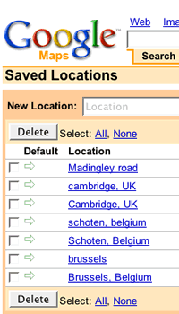 It would have been more intuitive to me to have a “Save this location” button next to the “Link to this page” button. At the moment, I still find it easier to bookmark permalinked Google maps views and then have Google Browser Sync backup my bookmarks for me. In other words, this new feature adds no value (for me).
There still no “open in Google Earth” button on the toolbar — we already know that appending “&output=kml” to the permlink is all it takes. Finally, I hope this is the first step to syncing my Google Earth placemarks with Google Maps — my Google Maps Saved Locations, my Google Earth Community posts and my Google Earth Places content are all similar — so why not make them syncable?